Council Meeting/Documents/Appendix 1: March 28, 2023 Ryzuk Proposed Foreshore Stabilization Site Plan with +/-35cm diameter and CJF added decayed / fractured holding root details
Appendix
Appendix 1: March 28, 2023 Ryzuk Proposed Foreshore Stabilization Site Plan with +/-35cm diameter and CJF added decayed / fractured holding root details
June 6, 2023Page 1841 section
Annotated site plan detailing specific root locations and conditions relative to the proposed construction.
Douglas-fir No.491 decayed / fractured holding root
CONCRETE JUNGLE FORESTRY LTD. Urban & Wildland Forest Assessment & Mapping
Appendix 1: March 28, 2023 Ryzuk Proposed Foreshore Stabilization Site Plan with +/-35cm diameter and CJF added decayed / fractured holding root details.
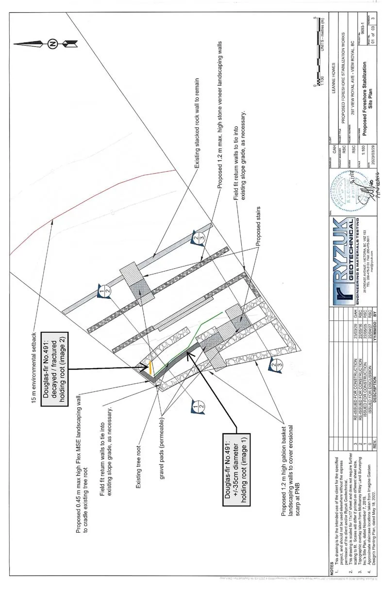
Drawing Annotations:
- 15 m environmental setback
- Douglas-fir No. 491: decayed / fractured holding root (image 2)
- Proposed 0.45 m max high Flex MSE landscaping wall to cradle existing tree root
- Field fit return walls to tie into existing slope grade, as necessary.
- Existing tree root
- gravel pads (permeable)
- Douglas-fir No. 491: +/-35cm diameter holding root (image 1)
- Proposed 1.2 m high gabion basket landscaping walls to cover erosional scarp at PNB
- Existing stacked rock wall to remain
- Proposed 1.2 m max. high stone veneer landscaping walls
- Field fit return walls to tie into existing slope grade, as necessary.
- Proposed stairs
Revision History
| REV. | DATE | DESCRIPTION | BY |
|---|---|---|---|
| 3 | 23/03/28 | RE-ISSUED FOR CONSTRUCTION | GAH |
| 2 | 22/05/16 | RE-ISSUED FOR CONSTRUCTION | RSC |
| 1 | 22/04/27 | RE-ISSUED FOR CONSTRUCTION | RSC |
| 0 | 18/05/18 | ISSUED FOR DISCUSSION | RSC |
Project Information
| Field | Detail |
|---|---|
| PROJECT | LEANNE HOWES |
| PROJECT NAME | PROPOSED FORESHORE STABILIZATION WORKS |
| PROJECT ADDRESS | 297 VIEW ROYAL AVE - VIEW ROYAL, BC |
| DRAWING TITLE | Proposed Foreshore Stabilization Site Plan |
| PROJECT NUMBER | 9093-1 |
| DRAWN BY | GAH |
| PROJECT MANAGER | RSC |
| CHECKED BY | RSC |
| DATE | 2023/03/28 |
| SCALE | 1:100 |
| SHEET | 01 of 03 |
NOTES
- This drawing is for the intended use of the client for the specified project, and should not be used elsewhere without the express permission of the client and/or Ryzuk Geotechnical.
- This drawing is scaled for 11x17 sheet and does not require further scaling to fit. Scales will differ if printed on different sheet size.
- Topographic overlay taken from McIvaney Riley Land Surveying Inc.'s Site Plan, dated November 7, 2019.
- Approximate staircase locations taken from Imagine Garden Design's Planning Plan, dated May 18, 2022.
Page 184
Extracted from: 2023 06 06 Council Agenda - Agenda - Pdf