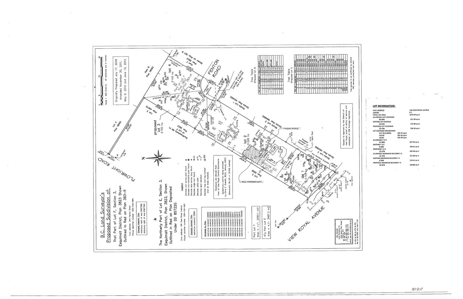
Attachment 3. Proposed Subdivision - Site Plan - 18 Fenton Road
Legal survey plan showing the existing and proposed structures on the 18 Fenton Road property.
B.C. Land Surveyor's Proposed Subdivision of:
That Part of Lot F, Section 3, Esquimalt District, Plan 3823 Shown Outlined in Red on Plan 383-R
Civic address: 244 Fenton Road Parcel identifier number 006-109-884 statutory right of way EH67389 statutory right of way EH67390
&
The Northerly Part of Lot E, Section 3, Esquimalt District, Plan 3823, Shown Outlined in Red on Plan Deposited Under DD 857220
Civic address 156 View Royal Avenue Parcel identifier number 006-108-593
Charges Appears Title
- restrictive covenant ED861
Annexed to Title
- restrictive covenant ED858
- restrictive covenant ED859
- restrictive covenant ED860
- restrictive covenant ED862
- restrictive covenant ED863
- restrictive covenant ED864
- restrictive covenant ED865
- restrictive covenant ED866
- restrictive covenant ED867
- restrictive covenant ED868
- restrictive covenant ED869
- restrictive covenant ED870
- restrictive covenant ED871
- restrictive covenant ED872
- restrictive covenant ED873
- restrictive covenant 794450
Areas
| Location | Area |
|---|---|
| Port Lot F | Area = +/- 2090.1 m2 |
| N'ly Part Lot E | Area = +/- 3487.2 m2 |
Legend
- ■ Denotes old survey post found
- □ Denotes non-standard post found
- ● Denotes standard iron post found
- OAI Denotes angle iron found
- ODP Denotes drill hole
- 0.00 Denotes spot elevation
- Denotes tree and tag number (not all trees located)
Elevations are derived from Town of View Royal datum. (preliminary control listing provided by Chris C. Everett, BCLS, January 2007) (Monument 06-25 = 18.849 metres)
Tree Table (Proposed Lot 4)
| TAG NO | SPECIES |
|---|---|
| 1 | 0.40 d. fir |
| 2 | 0.50 d. fir |
| 3 | 0.45 d. fir |
| 5 | 0.40 d. fir |
| 6 | 0.50 d. fir |
| 13 | 0.50 d. fir |
| 15 | 0.25 d. fir |
| 16 | 0.45 d. fir |
| 18 | 0.35 d. fir |
| 75 | 0.10 fir |
Tree Table (Proposed Lot 1)
| TAG NO | DIAMETER | SPECIES |
|---|---|---|
| 1 | 0.20 | d. fir |
| 2 | 0.25 | d. fir |
| 3 | 0.45 | d. fir |
| 17 | 0.20 | cherry |
| 19 | 0.15 | cherry |
| 21 | 0.15 | apple |
| 22 | 0.15 | apple |
| 23 | 0.25 | birch |
| 24 | 0.20 | birch |
| 25 | 0.25 | birch |
| 26 | 0.15 | cherry |
| 42 | 0.15 | apple |
| 43 | 0.15 | apple x2 |
| 44 | 0.20 | apple x3 |
| 45 | 0.15 | apple |
| 46 | 0.10 | apple |
| 47 | 0.10 | apple |
| 48 | 0.25 | d. fir |
| 50 | 0.20 | d. fir |
| 51 | 0.15 | d. fir |
| 52 | 0.10 | d. fir |
Tree species to be confirmed by arborist PRZ denotes protected root zone
LOT INFORMATION:
| Parameter | Value |
|---|---|
| CIVIC ADDRESS | 156 VIEW ROYAL AVENUE |
| ZONING | R-1 |
| TOTAL LOT AREA | 2279.99 sq m |
| ALLOWABLE LOT COVERAGE | |
| 40.00% | 911.99 sq m |
| EXISTING LOT COVERAGE | |
| 16.43% | 374.58 sq m |
| PROPOSED LOT COVERAGE | |
| 23.53% | 536.56 sq m |
| LOT COVERAGE BREAKDOWN | |
| OUT BUILDINGS | 100.45 sq m |
| HOUSE | 281.62 sq m |
| DECKS | 154.49 sq m |
| ALLOWABLE F.A.R. | |
| 42.00% | 957.59 sq m |
| EXISTING F.A.R. | |
| 6.99% | 159.41 sq m |
| PROPOSED F.A.R. | |
| 19.27% | 439.46 sq m |
| ALLOWABLE MAXIMUM BUILDING F.A. | |
| 16.31% | 372.00 sq m |
| EXISTING MAXIMUM BUILDING F.A. | |
| 6.99% | 159.41 sq m |
| PROPOSED MAXIMUM BUILDING F.A. | |
| 18.81% | 428.86 sq m |
Originally Prepared July 17, 2009 Amended November 30, 2011, May 9, 2012 and June 13, 2012
Subject to approval by the District of View Royal of subdivision and exemption of 10% frontage regulation
Scale 1 : 400 (metric) All distances are in metres