Appendix
Attachment 4. B.C. Land Surveyor's Sketch Plan - 18 Fenton Road
October 17, 2017Page 361 section
Surveyor's sketch identifying building corners and property lines for the proposed addition.
Prepared June 16, 2017
B.C. Land Surveyor's Sketch Plan of:
Lot 2, Section 3, Esquimalt District, EPP27852
Civic address: 18 Fenton Road Parcel identifier number: 029-030-048
Scale 1: 200 (metric) All distances are in metres.
Prepared for the sole purpose of indicating elevations at proposed building corners. To assist building designer (June 16, 2017).
Charged Against Title:
- statutory right of way EN67389
- statutory right of way EN67390
- restrictive covenant ED661
- easement CA3830156
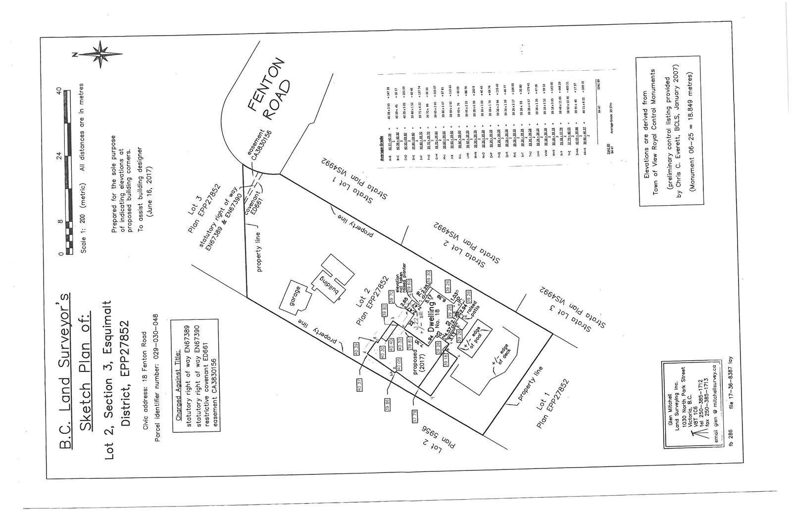
Average Grade Table
| Point | Calculation | Midpoint x Distance | Total |
|---|---|---|---|
| A+B | (40.37 + 40.39) / 2 | 40.38 x 3.65 | = 147.38 |
| B+C | (40.39 + 40.39) / 2 | 40.39 x 0.45 | = 18.17 |
| C+D | (40.39 + 40.30) / 2 | 40.35 x 5.02 | = 202.55 |
| D+E | (40.30 + 39.50) / 2 | 39.90 x 1.52 | = 60.65 |
| E+F | (39.50 + 39.70) / 2 | 39.60 x 0.90 | = 35.64 |
| F+G | (39.70 + 39.81) / 2 | 39.76 x 2.65 | = 105.37 |
| G+H | (39.81 + 39.38) / 2 | 39.60 x 2.22 | = 87.91 |
| H+I | (39.38 + 39.30) / 2 | 39.34 x 0.90 | = 35.41 |
| I+J | (39.30 + 39.90) / 2 | 39.60 x 2.92 | = 115.63 |
| J+K | (39.90 + 39.70) / 2 | 39.80 x 0.76 | = 30.25 |
| K+L | (39.70 + 39.20) / 2 | 39.45 x 2.25 | = 88.76 |
| L+M | (39.20 + 39.28) / 2 | 39.24 x 1.50 | = 58.86 |
| M+N | (39.28 + 39.30) / 2 | 39.29 x 1.25 | = 49.11 |
| N+O | (39.30 + 39.22) / 2 | 39.26 x 1.70 | = 66.74 |
| O+P | (39.22 + 39.30) / 2 | 39.26 x 2.94 | = 115.42 |
| P+Q | (39.30 + 39.26) / 2 | 39.28 x 1.25 | = 49.10 |
| Q+R | (39.26 + 39.26) / 2 | 39.26 x 2.17 | = 85.20 |
| R+S | (39.26 + 39.26) / 2 | 39.26 x 2.70 | = 106.00 |
| S+T | (39.26 + 39.26) / 2 | 39.26 x 0.53 | = 20.81 |
| T+U | (39.26 + 39.26) / 2 | 39.26 x 1.20 | = 47.11 |
| U+V | (39.26 + 39.26) / 2 | 39.26 x 0.70 | = 27.48 |
| V+W | (39.26 + 39.14) / 2 | 39.20 x 1.52 | = 59.58 |
| W+X | (39.14 + 39.22) / 2 | 39.18 x 3.65 | = 143.01 |
| X+Y | (39.22 + 37.79) / 2 | 38.51 x 11.65 | = 448.58 |
| Y+Z | (37.79 + 40.05) / 2 | 38.92 x 10.36 | = 403.21 |
| Z+AA | (40.05 + 39.86) / 2 | 39.96 x 4.45 | = 177.30 |
| AA+A | (39.86 + 40.37) / 2 | 40.11 x 8.22 | = 329.70 |
| Totals | 84.47 | 3342.89 |
Average Grade: 3342.89 / 84.47 = 39.57m
Elevations are derived from Town of View Royal Control Monuments (preliminary control listing provided by Chris C. Everett, BCLS, January 2007) (Monument 06-25 = 18.849 metres)
Glen Mitchell Land Surveying Inc. 1030 North Park Street Victoria, B.C. V8T 1C6 tel 250-385-1712 fax 250-385-1713 email glen@mitchellsurvey.ca
fb 286 file 17-36-8387 lay
Page 36
Extracted from: 2017 10 17 Council Agenda - Agenda - Pdf