Appendix
Map: Proposed Vancouver Island Transportation Plan
October 17, 2017Page 741 section
Annotated map showing proposed new highways and bridge connections for southern Vancouver Island.
Proposed route highlighted in pink
Southern Vancouver Island and Gulf Islands Map
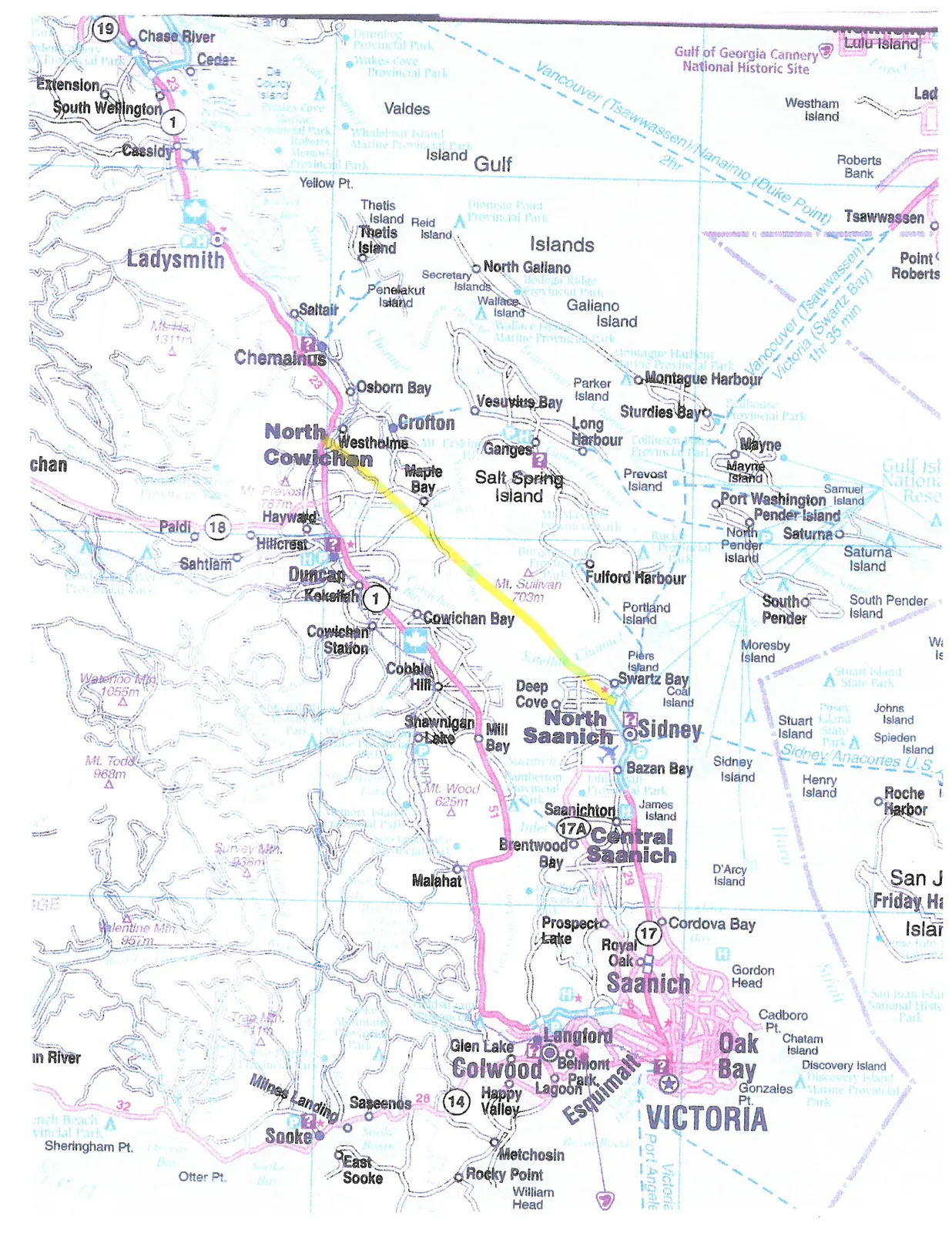
The map covers the southern tip of Vancouver Island, the Saanich Peninsula, and the surrounding Gulf Islands. Key locations and features depicted include:
Vancouver Island Communities and Regions
- Greater Victoria Area: Victoria, Oak Bay, Esquimalt, Saanich (including Royal Oak, Prospect Lake, and Cordova Bay).
- Western Communities: Colwood, Langford, Metchosin, and Sooke.
- Saanich Peninsula: Central Saanich (Brentwood Bay, Saanichton), North Saanich, and Sidney.
- Cowichan Valley: Mill Bay, Shawnigan Lake, Cobble Hill, Cowichan Bay, Duncan, and North Cowichan (including Westholme, Crofton, and Maple Bay).
- Northern Areas: Chemainus, Ladysmith, Cassidy, South Wellington, and Chase River.
Gulf Islands
- Salt Spring Island: Locations include Ganges, Fulford Harbour, and Vesuvius Bay.
- Galiano Island: Locations include Montague Harbour and Sturdies Bay.
- Pender Islands: North Pender and South Pender Islands, including Port Washington.
- Other Islands: Mayne Island, Saturna Island, Thetis Island, Reid Island, Valdes Island, and Kuper Island (Penelakut Island).
Transportation Infrastructure
- Highways:
- Highway 1 (Trans-Canada Highway) running north from Victoria through Duncan and Ladysmith.
- Highway 17 (Pat Bay Highway) connecting Victoria to the Swartz Bay ferry terminal.
- Highway 14 leading west to Sooke.
- Ferry Routes:
- Vancouver (Tsawwassen) to Nanaimo (Duke Point) - 2 hours.
- Vancouver (Tsawwassen) to Victoria (Swartz Bay) - 1 hour 35 minutes.
- Sidney to Anacortes, U.S.
- Inter-island ferry connections between Swartz Bay, Fulford Harbour, and the various Gulf Islands.
- Airports: Victoria International Airport is indicated near Sidney.
Geographical Features and Points of Interest
- Water Bodies: Gulf of Georgia, Haro Strait, Saanich Inlet, and various bays and sounds.
- Parks and Landmarks:
- Gulf of Georgia Cannery National Historic Site (Lulu Island).
- Various Provincial Parks (Dionisio Point, Wakes Cove, Montague Harbour, etc.).
- Major peaks such as Mt. Maxwell, Mt. Sullivan, and Mt. Wood.
Page 74
Extracted from: 2017 10 17 Council Agenda - Agenda - Pdf