Attachment 4. Renderings – Christopher Developments
Architectural renderings, site plans, and drainage plans for the proposed new home and accessory building at 265 View Royal Avenue.
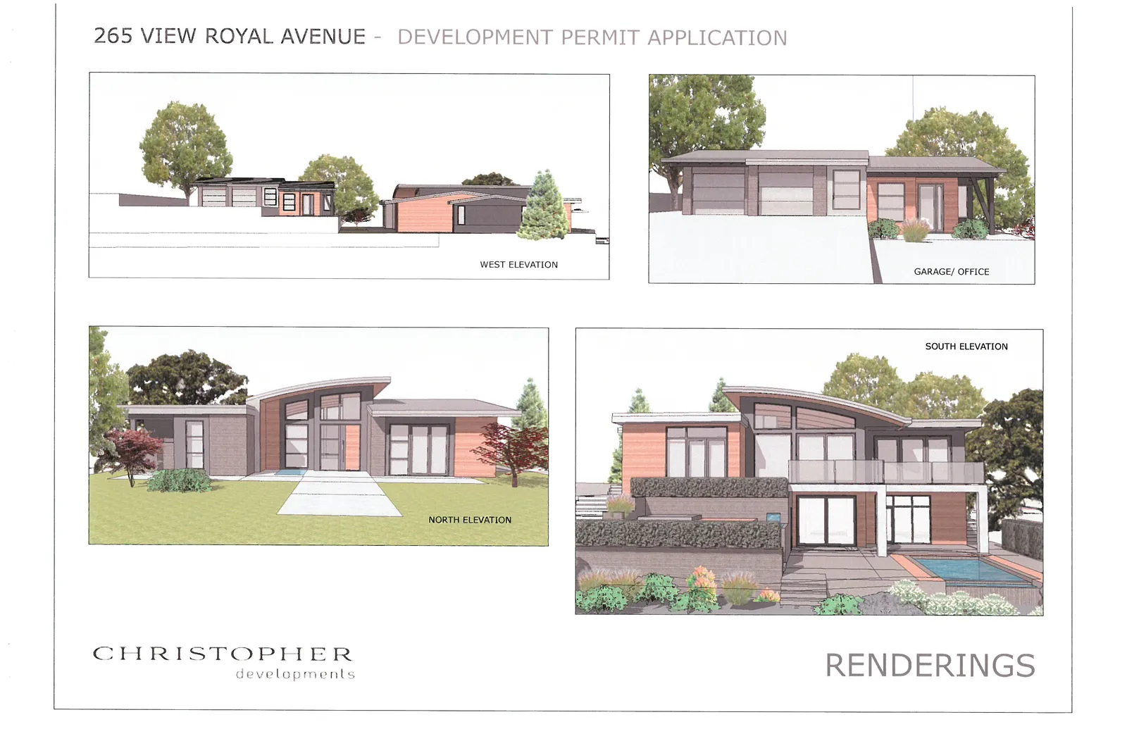
265 VIEW ROYAL AVENUE - DEVELOPMENT PERMIT APPLICATION
RENDERINGS
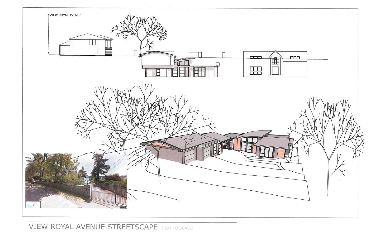
VIEW ROYAL AVENUE STREETSCAPE (NOT TO SCALE)
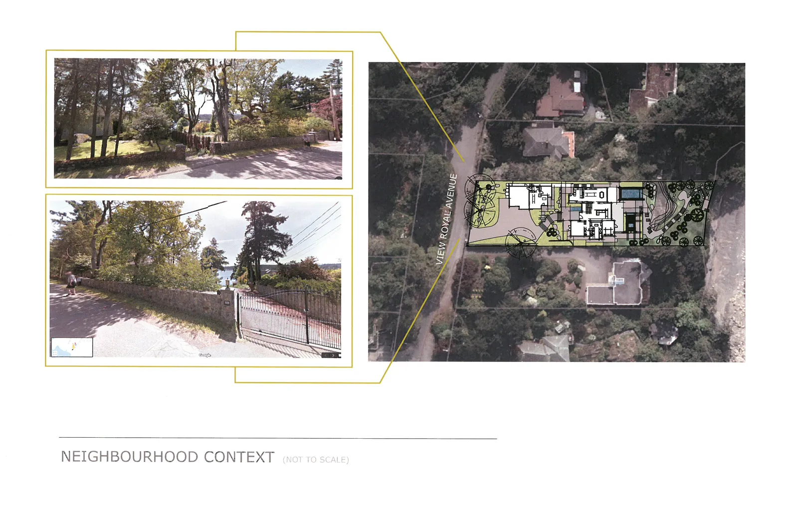
NEIGHBOURHOOD CONTEXT (NOT TO SCALE)
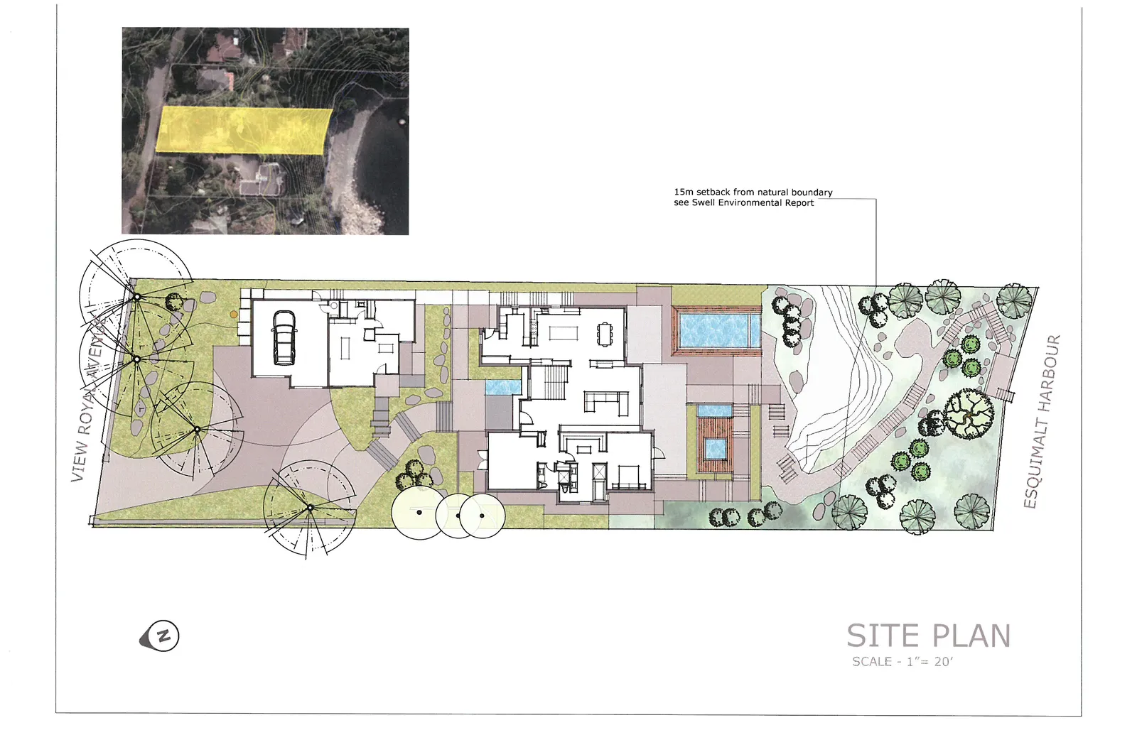
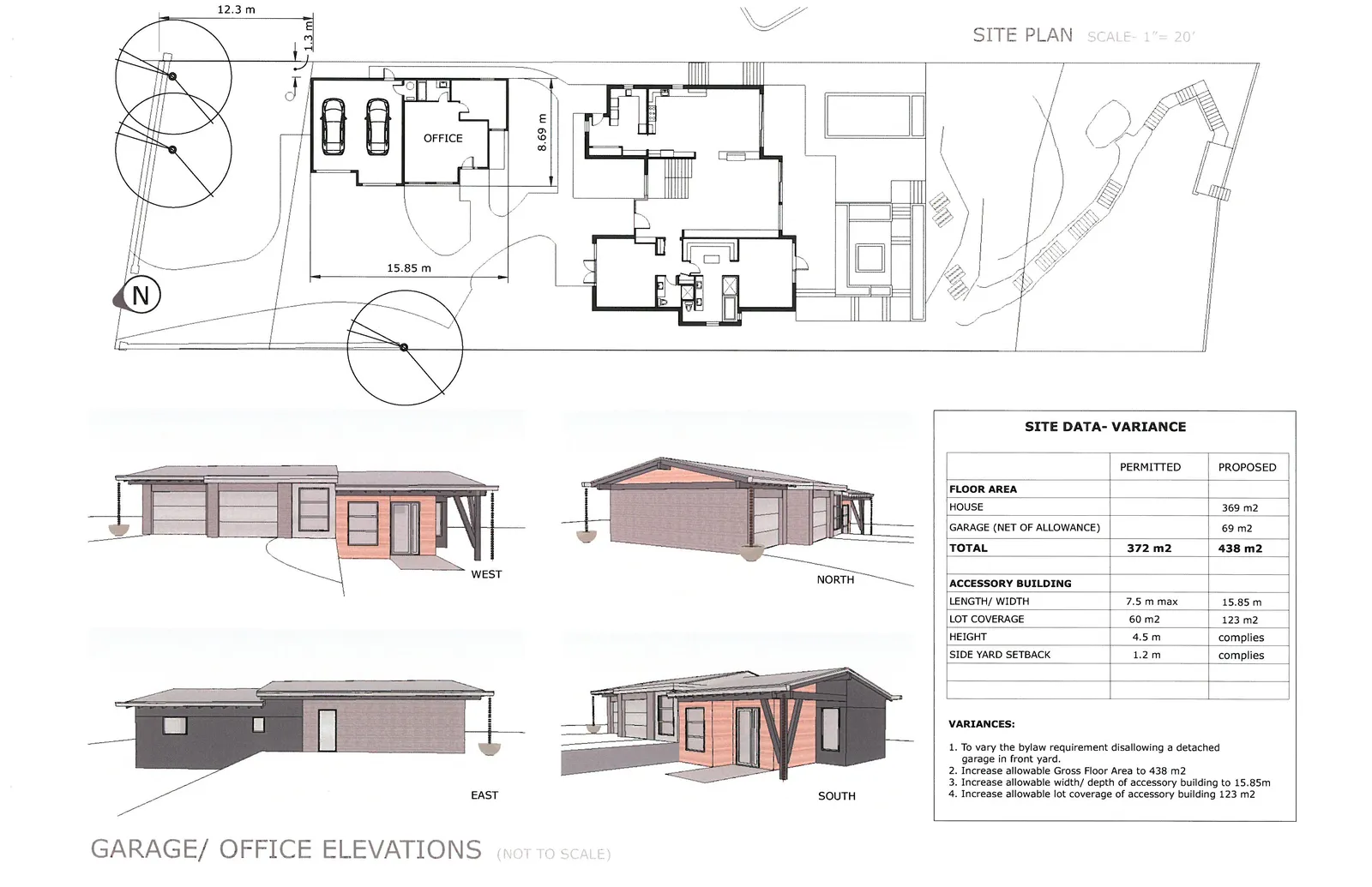
SITE PLAN
- 15m setback from natural boundary see Swell Environmental Report
- ESQUIMALT HARBOUR
- SCALE - 1" = 20'
SITE PLAN - GARAGE / OFFICE DETAIL
GARAGE/ OFFICE ELEVATIONS (NOT TO SCALE)
SITE DATA- VARIANCE
| PERMITTED | PROPOSED | |
|---|---|---|
| FLOOR AREA | ||
| HOUSE | 369 m2 | |
| GARAGE (NET OF ALLOWANCE) | 69 m2 | |
| TOTAL | 372 m2 | 438 m2 |
| ACCESSORY BUILDING | ||
| LENGTH/ WIDTH | 7.5 m max | 15.85 m |
| LOT COVERAGE | 60 m2 | 123 m2 |
| HEIGHT | 4.5 m | complies |
| SIDE YARD SETBACK | 1.2 m | complies |
VARIANCES:
- To vary the bylaw requirement disallowing a detached garage in front yard.
- Increase allowable Gross Floor Area to 438 m2
- Increase allowable width/ depth of accessory building to 15.85m
- Increase allowable lot coverage of accessory building 123 m2
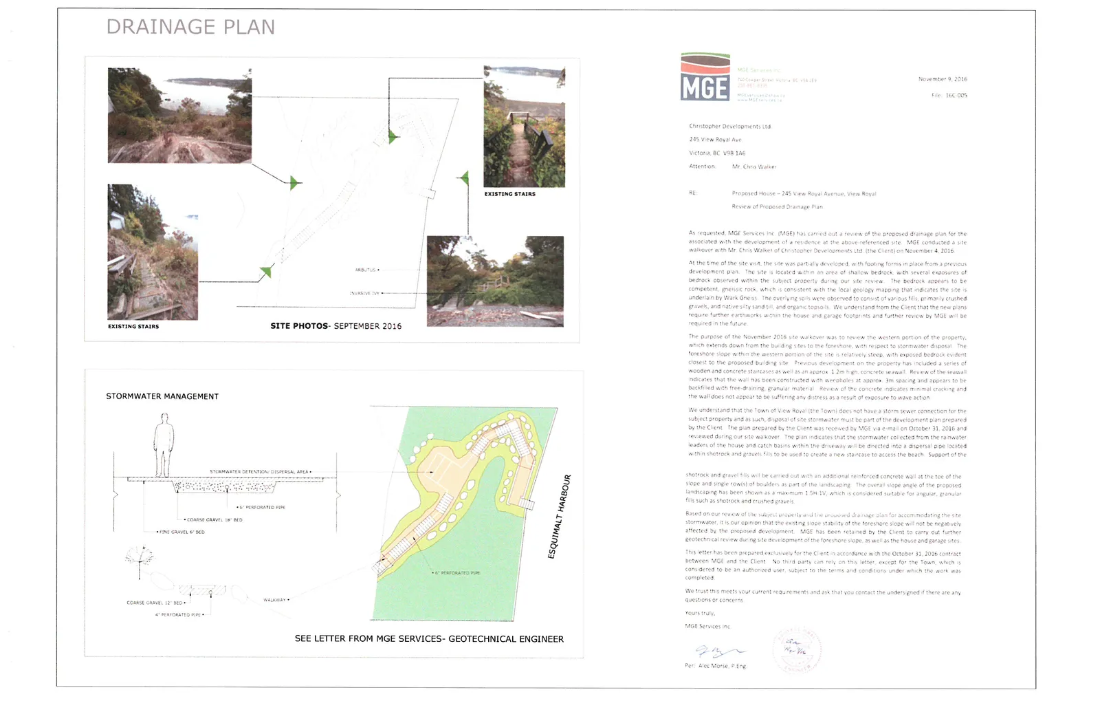
DRAINAGE PLAN
SITE PHOTOS- SEPTEMBER 2016
STORMWATER MANAGEMENT
SEE LETTER FROM MGE SERVICES- GEOTECHNICAL ENGINEER
MGE Services Inc. November 9, 2016 File: 16C-005
Christopher Developments Ltd. 245 View Royal Ave. Victoria, BC V9B 1A6
Attention: Mr. Chris Walker
RE: Proposed House – 245 View Royal Avenue, View Royal Review of Proposed Drainage Plan
As requested, MGE Services Inc. (MGE) has carried out a review of the proposed drainage plan for the associated with the development of a residence at the above-referenced site. MGE conducted a site walkover with Mr. Chris Walker of Christopher Developments Ltd. (the Client) on November 4, 2016.
At the time of the site visit, the site was partially developed, with footing forms in place from a previous development plan. The site is located within an area of shallow bedrock, with several exposures of bedrock observed within the subject property during our site review. The bedrock appears to be competent, gneissic rock, which is consistent with the local geology mapping that indicates the site is underlain by Wark Gneiss. The overlying soils were observed to consist of various fills, primarily crushed gravels, and native silty sand fill, and organic topsoils. We understand from the Client that the new plans require further earthworks within the house and garage footprints and further review by MGE will be required in the future.
The purpose of the November 2016 site walkover was to review the western portion of the property, which extends down from the building sites to the foreshore, with respect to stormwater disposal. The foreshore slope within the western portion of the site is relatively steep, with exposed bedrock evident closest to the proposed building site. Previous development on the property has included a series of wooden and concrete staircases as well as an approx. 1.2m high, concrete seawall. Review of the seawall indicates that the wall has been constructed with weepholes at approx. 3m spacing and appears to be backfilled with free-draining, granular material. Review of the concrete indicates minimal cracking and the wall does not appear to be suffering any distress as a result of exposure to wave action.
We understand that the Town of View Royal (the Town) does not have a storm sewer connection for the subject property and as such, disposal of site stormwater must be part of the development plan prepared by the Client. The plan prepared by the Client was received by MGE via e-mail on October 31, 2016 and reviewed during our site walkover. The plan indicates that the stormwater collected from the rainwater leaders of the house and runoff from within the driveway will be directed into a dispersal pipe located within shotrock and gravel fills to be used to create a new staircase to access the beach. Support of the shotrock and gravel fills will be carried out with an additional reinforced concrete wall at the toe of the slope and single row(s) of boulders as part of the landscaping. The overall slope angle of the proposed landscaping has been shown as a maximum 1.5H:1V, which is considered suitable for angular, granular fills such as shotrock and crushed gravels.
Based on our review of the subject property and the proposed drainage plan for accommodating the site stormwater, it is our opinion that the existing slope stability of the foreshore slope will not be negatively affected by the proposed development. MGE has been retained by the Client to carry out further geotechnical review during site development of the foreshore slope, as well as the house and garage sites.
This letter has been prepared exclusively for the Client in accordance with the October 31, 2016 contract between MGE and the Client. No third party can rely on this letter, except for the Town, which is considered to be an authorized user, subject to the terms and conditions under which the work was completed.
We trust this meets your current requirements and ask that you contact the undersigned if there are any questions or concerns.
Yours truly, MGE Services Inc.
Per: Alec Morse, P.Eng.