TOWN OF VIEW ROYAL Council Report - Request to Remove Covenant EK061366 on Meadow Vale Drive/Riverside Drive
Staff report recommending the removal of an environmental covenant from ten properties, noting that modern regulations provide equivalent protection.
TOWN OF VIEW ROYAL
Council Report
TO: Mayor and Council DATE: June 29, 2017 FROM: J. Chow, Senior Planner MEETING: July 18, 2017
Request to Remove Covenant EK061366 on Meadow Vale Drive/Riverside Drive
RECOMMENDATION:
THAT Covenant EK061366 on Meadow Vale Drive/Riverside Drive be removed from the titles of properties at 1927 Riverside Drive and 2187, 2203, 2215, 2227, 2239, 2251, 2263, 2275, and 2287 Meadow Vale Drive.
CHIEF ADMINISTRATIVE OFFICER’S COMMENTS:
I concur with the recommendation.
DIRECTOR OF DEVELOPMENT SERVICES’ COMMENTS:
I concur with the recommendation.
PURPOSE OF REPORT:
To consider a request remove Covenant EK061366 from the titles of properties located on Meadow Vale Drive and Riverside Drive.
BACKGROUND:
The subject properties at 1927 Riverside Drive and 2187, 2203, 2215, 2227, 2239, 2251, 2263, 2275, and 2287 Meadow Vale Drive (see Attachment 1) are ten residential parcels with single family dwellings built in the late 1990s. They are located on the west bank of Craigflower Creek, which is within Thetis Lake Regional Park. Covenant EK061366 (Attachment 2) was established in 1996 as part of the development process and applies to a 7.5 metre wide strip of land parallel to the rear lot lines. In most cases, the covenant areas cover nearly the entire rear yards. The covenant generally states that other than a fence, nothing may be built in the covenant area and that trees, shrubs, ground cover and plant life of a certain size are not to be removed without Town approval.
Once the covenant was registered on the properties, it is understood that the Town relied on the developer and property owners to adhere to the requirements described therein. On March 4, 1998 the Environment Committee considered an April 1997 report titled “Craigflower Watershed Assessment” prepared for the Capital Regional District (View Royal, Langford, Saanich and Highlands) by SHIP Environment Consultants Ltd. indicating “concern was raised that developments along Craigflower Creek encroached upon easements and conservation measures, and that compliance was not strictly enforced.”
In 2007 Council supported a program to monitor properties on which covenant areas were established. The subject properties were inspected by Halladay Environmental Consultants as part of that program and a report (Attachment 3) was prepared that identified a significant number of breaches. The report shows retaining walls, patios, and structures in the covenant area and that common back yard features such as lawns and garden beds were established. The report recommended removal of the covenant for the following reasons:
- “…the terrain, soils and drainage in all lots have been altered significantly and there are no unmodified ecosystems or plant communities present, except to a limited extent…”
- “… the natural values of all part of the covenant have been lost to the impacts of historic residential development and ongoing residential use.”
- “…the covenant cannot be restored to- or maintained in- a natural state given;
- The locations of houses and other permanent structures adjoining or within the covenant,
- Our understanding of the standards for fire safety adjacent to residential developments employed by the Town (i.e. 10m wide zone free of significant natural fuels).”
To staff’s knowledge, the Halladay report was not provided to Council at the time. The program concluded after the initial inspection and there were no further actions.
On February 7, 2017, Council received a petition signed by owners of the subject properties. This petition requested authorization to remove Covenant EK061366 from the subject properties. At the March 14, 2017 Committee of the Whole meeting, the Town agreed to cost share with the petitioners the preparation of a Riparian Areas Assessment in order to understand the implications of removing the covenant. A Riparian Areas Assessment is a report prepared by a Qualified Environmental Professional mandated by the Province to identify the Streamside Protection and Enhancement Area (SPEA), which is the specific area that can affect riparian habitat. Riparian Area Assessments are filed in a Provincial registry.
DISCUSSION
The request can be supported because the Provincial Riparian Areas Regulations and the Town’s resulting Natural Watercourse and Shoreline Area Development Permit Area guidelines are now in place to prevent the degradation of valuable riparian fish habitat adjacent to Craigflower Creek.
The rear yards of the subject properties are located in the Natural Watercourse and Shoreline Area Development Permit Area which establishes guidelines (Attachment 4) with regard to Riparian Areas Regulations to protect this area and to facilitate development that meets environmental protection objectives. The guidelines identify certain activities that are exempt from a requirement for a Development Permit including specific landscaping activities and limited building activities. It is likely that any additions to houses or extensive landscaping would trigger the Development Permit requirements and applications would be considered by Council (or the Director of Development Services where this authority has been delegated). A net increase in native plant vegetation would be supported by the guidelines.
Figure 1. Streamside Protection and Enhancement Area (SPEA in hatched area)
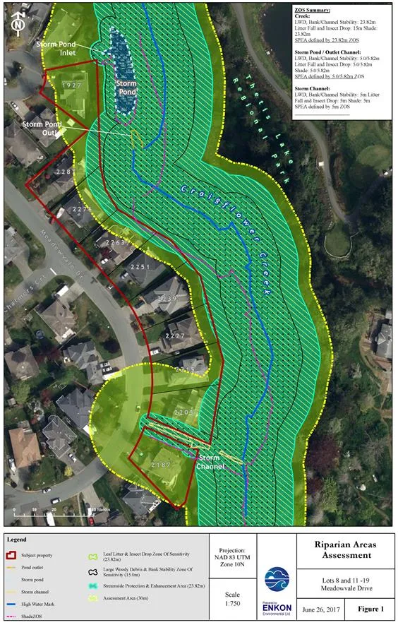
The Riparian Areas Assessment has determined that the SPEA does extend onto a number of the subject properties but only occupies about half of the total covenant area as shown in the hatched area in Figure 1. Existing uses within the SPEA that predate the Riparian Areas Regulations are allowed to continue, with restrictions on any new activities that may affect the riparian area. While the Qualified Environment Professional indicates in a supplemental letter (Attachment 5) that while there are some invasive species present, the riparian vegetation is diverse. The letter further clarifies that the Riparian Areas Assessment follows Provincial reporting format, meaning that the recommended mitigation measures in Section 4 of the Riparian Areas Assessment would only relate to any new proposed development or land alteration activities, not to the properties as they are today.
For the five properties where the SPEA occupies more than half of the rear yards, the main implication is that new impervious surfaces such as patios and accessory buildings on permanent foundations would not be permitted. Comments from the Capital Regional District are expected on some minor fence encroachments into the Thetis Lake Regional Park.
CONCLUSION
The request to remove Covenant EK061366 from the titles of the subject properties can be supported because the Riparian Areas Regulations and the Natural Watercourse and Shoreline Area Development Permit Area since been instituted to protect the key areas of sensitivity for the Craigflower Creek riparian area using a more fine-tuned, science based approach. If approved, the subject property owners can continue to enjoy use their rear yards as they are and can apply for development permits for land alteration that would ensure riparian habitat is protected or enhanced. If the request is approved pending comments from the Capital Regional District on fence encroachments, the Town would cost share removal of the covenant with the petitioners.
RECOMMENDATION:
THAT Covenant EK061366 on Meadow Vale Drive/Riverside Drive be removed from the titles of properties at 1927 Riverside Drive and 2187, 2203, 2215, 2227, 2239, 2251, 2263, 2275, and 2287 Meadow Vale Drive.
SUBMITTED BY: J. Chow, MCIP, RPP, Senior Planner
REVIEWED BY: L. Chase, MCIP, RPP, Director of Development Services
ATTACHMENTS:
- Property Location Map
- Covenant EK061366 (8 pages)
- Meadowvale Drive Covenant Monitoring: Initial Inspection Report – Halladay Environmental Consultants Ltd., December 19, 2007 (35 pages)
Document Images
(3)