Attachment 9: Thetis Lake Campground Transportation Impact Assessment
Comprehensive traffic study analyzing the impact of the redevelopment on local intersections and recommending infrastructure improvements.
Title: THETIS LAKE CAMPGROUND Transportation Impact Assessment Prepared for: Limona Prepared by: Watt Consulting Group Ltd. Our File: 2187.B01 Date: June 26, 2017
TABLE OF CONTENTS
1.0 INTRODUCTION ................................................................................................... 1 1.1 Background to this Study ...................................................................................... 1 2.0 TRANSPORTATION NETWORK ......................................................................... 2 2.1 Existing Road Network ......................................................................................... 2 2.2 Future Road Network ............................................................................................ 2 3.0 EXISTING CONDITIONS ...................................................................................... 2 3.1 Existing Traffic Volumes ........................................................................................ 2 3.2 Background Traffic Volumes – Future Horizons .................................................... 3 4.0 PROPOSED DEVELOPMENT .............................................................................. 3 4.1 Proposed Land Use ............................................................................................... 3 4.2 Site Access ............................................................................................................ 4 4.3 Trip Generation ..................................................................................................... 4 4.4 Trip Distribution and Assignment........................................................................... 5 4.5 Intersection Performance Evaluation .................................................................... 6 5.0 OPENING DAY ..................................................................................................... 7 5.1 AM Peak Hour ....................................................................................................... 8 5.2 PM Peak Hour ..................................................................................................... 10 5.3 10 Year Horizon .................................................................................................. 12 5.3.1 AM Peak Hour ......................................................................................... 12 5.3.2 PM Peak Hour ......................................................................................... 14 6.0 ROAD GEOMETRY ............................................................................................ 15 7.0 ALTERNATIVE MODES ..................................................................................... 15 7.1 Pedestrians ......................................................................................................... 15 7.2 Bicycles ............................................................................................................... 16 7.3 Transit ................................................................................................................. 16 8.0 CONCLUSIONS .................................................................................................. 16 9.0 RECOMMENDATIONS ....................................................................................... 17
LIST OF FIGURES
Figure 1: Site Context ................................................................................................................... 1 Figure 2: Proposed Development ................................................................................................. 4 Figure 3: AM Peak Hour Trip Distribution ..................................................................................... 5 Figure 4: PM Peak Hour Trip Distribution ..................................................................................... 6
LIST OF TABLES
Table 1: AM Peak Hour Trip Generation ............................................................................. 4 Table 2: PM Peak Hour Trip Generation ............................................................................. 5 Table 3: Los Criteria for Intersections ................................................................................. 7 Table 4: AM 2025 Traffic Conditions ................................................................................... 8 Table 5: PM 2025 Traffic Conditions ................................................................................. 10 Table 6: AM 2035 Traffic Conditions ................................................................................. 12 Table 7: PM 2035 Traffic Conditions ................................................................................. 14
1.0 INTRODUCTION
1.1 BACKGROUND TO THIS STUDY
Watt Consulting Group was retained by Limona Group to complete a Transportation Impact Assessment (TIA) in support of the redevelopment of the Thetis Lake Campground Site. The existing Thetis Lake Campground and mobile home site is proposed to be redeveloped to townhouses and condominiums. The existing access off West Park Lane will continue to be utilized to access the development. See Figure 1 for site location.
Figure 1: Site Context
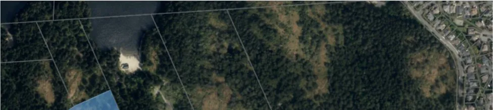
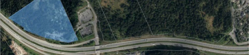
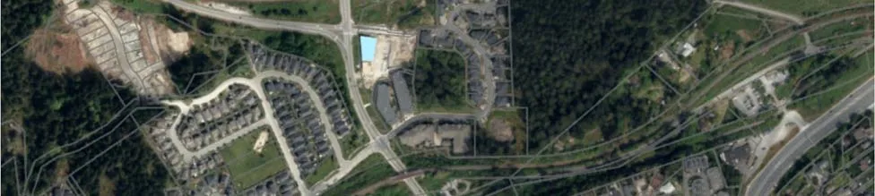
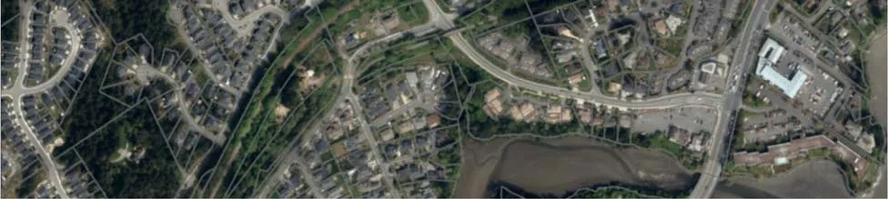
The Thetis Lake Recreational area is a popular year round hiking area; however, in the summer months there is a significant spike in use due to the popularity of the area for swimming. There is limited transit service to the area which leads to higher vehicle demand as well as pedestrians walking along Six Mile Road to access transit service.
2.0 TRANSPORTATION NETWORK
2.1 EXISTING ROAD NETWORK
The site is accessed off West Park Lane which provides access to the existing campground as well as the parking lots for the Thetis Lake Recreational area. Six Mile Road connects to West Park Lane, the Highway 1 ramps, and Island Highway. Technically Six Mile Road forms part of the Six Mile Interchange as part of the ramps from Highway 1 to Island Highway; however, the road also provides access to residential/commercial developments and local and collector roads in View Royal. Six Mile Road is a two lane roadway with an urban cross section and is classified as an arterial road in View Royal. Access to Six Mile Road is via the eastbound off ramp and westbound on ramp for the interchange and via Island Highway. Due to the design of the Six Mile Interchange only half of the interchange is near the site. The other half is accessed off Island Highway/Burnside Road. Island Highway is a four lane (five to six lane cross section) arterial road with mixed urban/rural cross section. Atkins Road is a collector road, while all other roads within the study area are local roadways.
The intersection of the eastbound off ramp is stop/yield controlled on the ramp and free-flow on Six Mile Road, while the on ramp intersection also has free-flow conditions on Six Mile Road. The east leg of the off ramp is Presley Place which is stop controlled. Atkins Road/Six Mile Road and Chilco Road/Nursery Hill Drive/Six Mix Road are both stop controlled. The intersection of Six Mile Road/Island Highway is signalized with turn lanes on all approaches except out of the strata development.
2.2 FUTURE ROAD NETWORK
The Town of View Royal is planning to implement a single lane roundabout at the intersection of Six Mile Road / Atkins Road. It is unknown at this time when the roundabout will be implemented by the Town. The timing for the roundabout will depend on the continued growth on both Six Mile Road and Atkins Road; however, if they continue to growth at 2.5% per year it is expected that within 5 years (2022) the westbound movement (on Atkins Road) will be operating with 2.5 minutes of delay on average during the PM peak hour. Delays in the AM Peak hour would be approximately one minute in length.
3.0 EXISTING CONDITIONS
3.1 EXISTING TRAFFIC VOLUMES
Traffic volumes for Six Mile Road and the ramps were collected during a PM peak hour (4-5pm) traffic count on April 26, 2017. These traffic volumes were then compared to data from the BC MoTI Permanent Traffic Count stations on Six Mile Road north of the on ramp and on the off ramp to determine the summer adjustment due to increased summer use of Thetis Lake. The results of the April to July 2016 comparison found that there is minimal change in PM peak hour traffic on the off ramp; however, the volume of traffic entering/exiting the recreational area on Six Mile Road increases by 50 to 100 vph in the summer during the PM peak hour. In the AM period, a review of the spring to summer traffic volume data found that spring data was higher. Therefore the spring AM count data was utilized to represent the higher volumes.
A PM peak hour traffic count was also undertaken on April 27, 2017 for the intersection of Six Mile Road/Island Highway. AM and PM peak hour counts were undertaken on May 17, 2017 (7:30am-8:30am and 4-5pm) for Chilco Road/Six Mile Road and Atkins Road/Six Mile Road. An AM peak hour count was undertaken at Six Mile Road/Island Highway on April 28, 2017. Single hour counts are typical for providing representative volumes for intersections when taken in part with permanent count stations indicating periods with higher volumes, adjustments for spring to summer, and when volumes are near capacity (i.e. on Island Highway).
PM peak hour traffic volumes are significantly higher on Six Mile Road in the PM peak period than during the AM peak period. At Six Mile Road/Island Highway the AM peak hour volumes entering the intersection are higher than in the PM peak hour; however, in both periods there is significant volume at this intersection.
3.2 BACKGROUND TRAFFIC VOLUMES – FUTURE HORIZONS
Using the permanent count station data (2007 to 2016) the growth in traffic on Six Mile Road and the ramps was determined to be between 2.25 and 2.5%. To be conservative a rate of 2.5% was used for traffic on Six Mile Road and the Ramps. For Island Highway a rate of 2% was used to obtain the opening day (2025). After 2025 the through volumes on Island Highway were held steady as additional growth, through on Island Highway would exceed the through capacity of a four lane road and rather than the hourly volume increasing any increase in volume would occur by a spreading of ‘peak’ traffic over a longer period of time. See Appendix A for 2025 Background traffic volumes.
The use of the 2.5% growth rate on all movements along Six Mile Road reflect potential future developments including those at 301 Nursery Hill Drive and 450 Presley Place. The 2.5% growth rate reflects the change in the Thetis Lake area over the past 10 years which includes the significant growth of the Thetis Vale area. See Appendix B for 2035 Background traffic volumes.
4.0 PROPOSED DEVELOPMENT
4.1 PROPOSED LAND USE
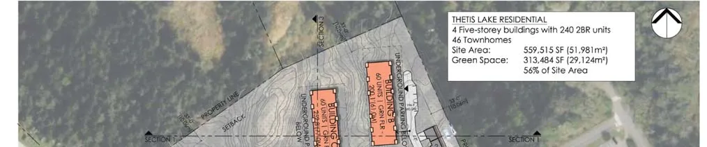
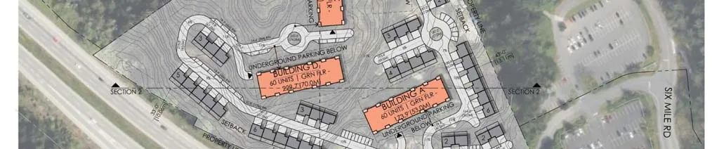
The proposed land use for the site is shown in Figure 2. The proposed development would remove the existing mobile homes and campground and build 46 townhouses and 240 condominiums. At the time of the study a count of existing mobile homes/trailers on the site was 35.
Figure 2: Proposed Development

4.2 SITE ACCESS
The site access will be via the existing access off West Park Lane.
4.3 TRIP GENERATION
The trip generation for the proposed land use within the study area was based on ITE Trip Generation Manual’s rates for Townhouse/Condominium. The development is planned to be built out over an eight year period. The full-build development intensity along with the resulting trip generation due to the removal of the existing mobile homes is summarized in Tables 1 and 2.
TABLE 1: AM PEAK HOUR TRIP GENERATION
| Land Use | Units | Rate | Trips IN | Trips OUT | Total Trips |
|---|---|---|---|---|---|
| Condominium | 240 | 0.44/unit | 18 | 88 | 106 |
| Townhouses | 46 | 0.44/unit | 17 | 3 | 20 |
| Existing Mobile Home | 35 | 0.44/unit | -12 | -3 | -15 |
| Total | 23 | 88 | 111 |
TABLE 2: PM PEAK HOUR TRIP GENERATION
| Land Use | Units | Rate | Trips IN | Trips OUT | Total Trips |
|---|---|---|---|---|---|
| Condominium | 240 | 0.52/unit | 84 | 41 | 125 |
| Townhouses | 46 | 0.52/unit | 16 | 8 | 24 |
| Existing Mobile Home | 35 | 0.59/unit | -13 | -8 | -21 |
| Total | 87 | 41 | 128 |
4.4 TRIP DISTRIBUTION AND ASSIGNMENT
The trip distribution for the site-generated traffic was established using the existing travel patterns in the area including at the ramps and Six Mile/Island Highway. Trips were all assigned to the south of the site. See Figures 3 and 4 for Trip Distribution.
Figure 3: AM Peak Hour Trip Distribution
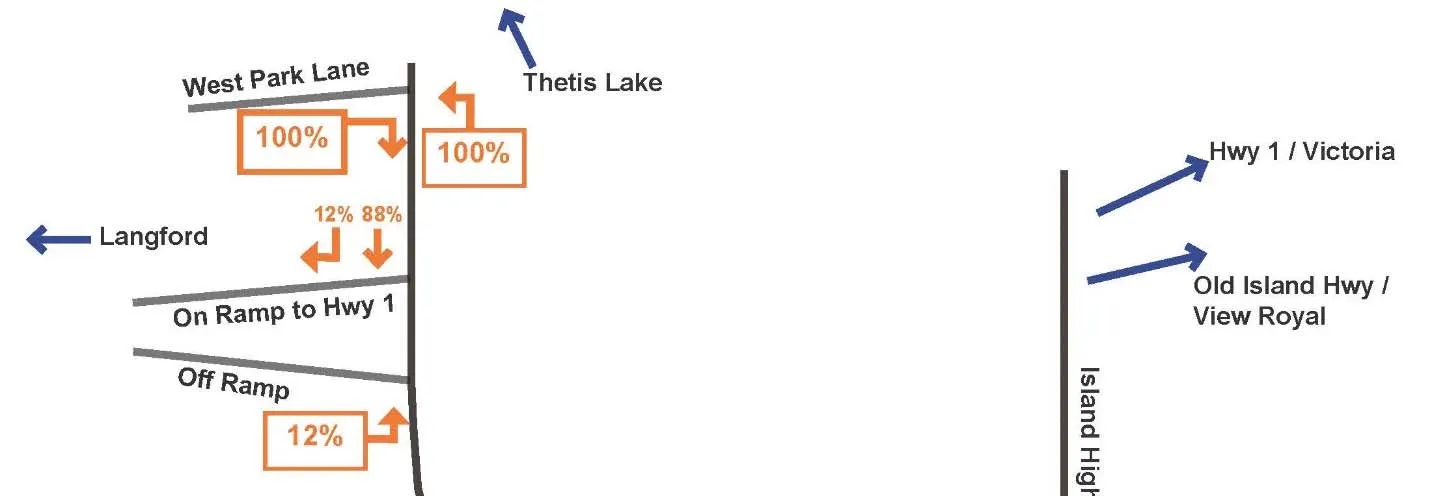

Figure 4: PM Peak Hour Trip Distribution [Diagram: PM Peak Hour Trip Distribution]
4.5 INTERSECTION PERFORMANCE EVALUATION
The operating conditions during the peak hours at the study intersections were evaluated using the Synchro/SimTraffic software package, which is based on the Highway Capacity Manual (HCM 2010) evaluation methodology.
For un-signalized (stop-controlled) intersections, the Level-of-Service (LOS) is based on the computed delays on each of the critical movements. LOS ‘A’ represents minimal delays for minor street traffic movements, and LOS ‘F’ represents a scenario with an insufficient number of gaps on the major street for minor street motorists to complete their movements without significant delays.
For signalized intersections, the methodology considers the intersection geometry, traffic volumes, the traffic signal phasing/timing plan, and also pedestrian volumes. The average delay for each lane group is calculated, as well as the delay for the overall intersection. The operating conditions can also be expressed in terms of volume to capacity (v/c) ratios. LOS criteria for both unsignalized and signalized intersections, as summarized in the Highway Capacity Manual, are illustrated in Table 3.
TABLE 3: LOS CRITERIA FOR INTERSECTIONS
| Level of Service (LOS) | Average Delay for UNSIGNALIZED Intersection Movements | Average Delay for SIGNALIZED Intersection Movements |
|---|---|---|
| A | 0 – 10 seconds per vehicle | 0 – 10 seconds per vehicle |
| B | > 10 – 15 seconds per vehicle | > 10 – 20 seconds per vehicle |
| C | > 15 – 25 seconds per vehicle | > 20 – 35 seconds per vehicle |
| D | > 25 – 35 seconds per vehicle | > 35 – 55 seconds per vehicle |
| E | > 35 – 50 seconds per vehicle | > 55 – 80 seconds per vehicle |
| F | > 50 seconds per vehicle | > 80 seconds per vehicle |
For the roundabout at Atkins Road / Six Mile Road SIDRA software will be used to analyze the traffic conditions.
5.0 OPENING DAY
Opening day of the full development is expected to occur in 2025. Therefore 2025 was analyzed as the opening year for post development conditions. The post development traffic volumes were determined by adding the site-generated volumes to the background traffic volumes. The post development peak hour traffic volumes and the resulting traffic operations are presented below.
See Appendix C for 2025 AM and PM Post Development Traffic Volumes.
5.1 AM PEAK HOUR
Table 4 outlines the AM peak hour conditions.
TABLE 4: AM 2025 TRAFFIC CONDITIONS
| Intersection/Movement | Background LOS | Background Delay (s) | Background Queue (m) | Post Development LOS | Post Development Delay (s) | Post Development Queue (m) |
|---|---|---|---|---|---|---|
| Six Mile Road (NB/SB) / On Ramp | ||||||
| NBL | A | 7.5 | 2.4 | A | 7.8 | 2.7 |
| NBT | A | 0.0 | 0.0 | A | 0.0 | 0.0 |
| SB | A | 0.0 | 0.0 | A | 0.0 | 0.0 |
| Six Mile Road (NB/SB) / Off Ramp / Presley Place (EB/WB) | ||||||
| NBT/R | A | 0.0 | 0.0 | A | 0.0 | 0.0 |
| SBL/T | A | 0.0 | 0.0 | A | 0.0 | 0.0 |
| EBL/T | B | 10.1 | 0.4 | B | 10.1 | 7.2 |
| EBR | A | 9.4 | 6.3 | B | 10.1 | 7.2 |
| WBL/R | B | 11.4 | 1.4 | B | 12.6 | 1.7 |
| Six Mile Road (NB/SB) / Chilco / Nursery Hill Drive (EB/WB) | ||||||
| NB | A | 1.5 | 0.1 | A | 1.5 | 0.8 |
| SB | A | 0.1 | 0.7 | A | 0.1 | 0.1 |
| EBL | C | 15.3 | 1.9 | C | 17.3 | 2.3 |
| EBT/R | B | 11.9 | 9.5 | B | 13.2 | 11.1 |
| WB | C | 24.4 | 6.9 | D | 30.4 | 8.8 |
| Six Mile Road (NB/SB) / Atkins (EB/WB) | ||||||
| NB | A | 0.9 | 0.7 | A | 0.9 | 0.8 |
| SB | A | 2.2 | 1.7 | A | 2.3 | 1.8 |
| EB | D | 34.1 | 51.7 | F | 51.7 | 68.9 |
| WB | F | 110.6 | 13.4 | F | 227.4 | 19.8 |
| Six Mile Road (EB/WB) / Island Highway (NB/SB) | ||||||
| NBL | A | 7.4 | 8.6 | A | 7.6 | 9.2 |
| NBT/R | D | 41.9 | #457.6 | D | 41.9 | #457.6 |
| SBL | C | 23.2 | 1.7 | C | 23.5 | 1.7 |
| SBT | B | 13.6 | 121.1 | B | 13.7 | 121.8 |
| SBR | A | 3.1 | 11.3 | A | 3.2 | 11.7 |
| EBL/T | F | 293.8 | #192.8 | F | 370.9 | #221.3 |
| EBR | C | 21.7 | 15.2 | C | 26.2 | 19.9 |
| WB | E | 68.7 | 15.6 | E | 69.0 | 15.6 |
# indicates traffic was simulated for two complete cycles of the 95th percentile traffic to account for the effects of spillover between cycles. If the v/c is less than 1.0 for the movement then this is a valid method for estimating the 95th percentile queue. In practice the 95th percentile queue shown will rarely be exceeded and the queues shown with the # are acceptable for design. In the AM peak hour the EBL and NBT movement have a v/c > 1.0.
The results of the Synchro analysis shown in Table 4 lead to following conclusions:
- The on and off-ramp intersections with Six Mile Road will continue to operate at a LOS A/B at full build-out and the change in delay is less than 1 second. The additional of the development has no impact on these intersections.
- The impact to Presley Place is less than 1 seconds of additional delay.
- At Chilco Road/Six Mile Road the westbound movement will drop in LOS to a D; however, this is still an acceptable LOS.
- If the intersection of Six Mile Road / Atkins Road was a roundabout it would operate at a LOS A.
- At Six Mile Road/Island Highway, there will be background issues with the eastbound left/through operating at a LOS F (failing) and having queuing issues. The development traffic will add additional delay to this failing movement, but not have a significant impact on any of the other movements. The northbound through movement also has a significant queue length that may be longer than indicated in Table 4.
5.2 PM PEAK HOUR
Table 5 provides details on the traffic operations during the PM peak hour.
TABLE 5: PM 2025 TRAFFIC CONDITIONS
| Intersection/Movement | Background LOS | Background Delay (s) | Background Queue (m) | Post Development LOS | Post Development Delay (s) | Post Development Queue (m) |
|---|---|---|---|---|---|---|
| Six Mile Road (NB/SB) / On Ramp | ||||||
| NBL | A | 8.9 | 11.5 | A | 9.1 | 12.2 |
| NBT | A | 0.0 | 0.0 | A | 0.0 | 0.0 |
| SB | A | 0.0 | 0.0 | A | 0.0 | 0.0 |
| Six Mile Road (NB/SB) / Off Ramp / Presley Place (EB/WB) | ||||||
| NBT/R | A | 0.0 | 0.0 | A | 0.0 | 0.0 |
| SBL/T | A | 0.0 | 0.0 | A | 0.0 | 0.0 |
| EBL/T | B | 10.6 | 6.5 | B | 11.5 | 6.5 |
| EBR | B | 10.6 | 6.5 | B | 11.9 | 6.9 |
| WBL/R | C | 18.6 | 2.1 | C | 21.6 | 2.6 |
| Six Mile Road (NB/SB) / Chilco / Nursery Hill Drive (EB/WB) | ||||||
| NB | A | 2.7 | 2.8 | A | 2.7 | 2.9 |
| SB | A | 0.6 | 0.4 | A | 0.6 | 0.4 |
| EBL | E | 37.3 | 6.8 | E | 46.8 | 8.5 |
| EBT/R | B | 10.5 | 2.6 | B | 10.8 | 2.7 |
| WB | E | 36.5 | 8.0 | E | 45.6 | 10.0 |
| Six Mile Road (NB/SB) / Atkins (EB/WB) | ||||||
| NB | A | 0.5 | 0.4 | A | 4.7 | 5.9 |
| SB | A | 4.5 | 5.7 | A | 0.6 | 0.4 |
| EB | E | 43.4 | 28.2 | F | 66.7 | 38.2 |
| WB | F | 353.4 | 77.8 | F | 517.0 | 89.0 |
| Six Mile Road (EB/WB) / Island Highway (NB/SB) | ||||||
| NBL | F | 139.9 | #83.8 | F | 134.8 | #89.8 |
| NBT/R | B | 10.2 | 138.1 | B | 10.3 | 138.1 |
| SBL | B | 14.0 | 1.7 | B | 14.8 | 1.7 |
| SBT | D | 50.5 | #440.2 | E | 60.1 | #448.0 |
| SBR | B | 12.5 | 91.7 | B | 15.5 | 114.4 |
| EBL/T | F | 95.8 | #86.9 | F | 100.6 | #96.1 |
| EBR | B | 16.6 | 11.8 | B | 16.0 | 11.2 |
| WB | A | 1.9 | 0.0 | A | 1.9 | 0.0 |
# indicates traffic was simulated for two complete cycles of the 95th percentile traffic to account for the effects of spillover between cycles. If the v/c is less than 1.0 for the movement then this is a valid method for estimating the 95th percentile queue. In practice the 95th percentile queue shown will rarely be exceeded and the queues shown with the # are acceptable for design. In the PM peak hour the NBL and SBT movements have a v/c > 1.0.
The results of the Synchro analysis shown in Table 5 lead to following conclusions:
- The on and off-ramp intersections with Six Mile Road will continue to operate at a LOS A/B at full build-out and the change in delay is less than 1.5 second. The additional of the development has no impact on these intersections.
- The impact to Presley Place is less than 2 seconds of additional delay.
- At Chilco Road/Six Mile Road the left turn from Chilco Road is currently operating at a LOS E and will continue to with the addition of the development. Similarly the Nursery Hill Drive movement will operate at a LOS E with and without this development. Although these movements operate at a LOS E; the amount of delay is 45 seconds on average and is only an issue for one hour of the day (PM Peak Hour) in 2025. No mitigation is required in 2025 to address these delays.
- If a roundabout is implemented at Six Mile Road / Atkins Road it will operate at a LOS A. It is recommended that the roundabout be implemented in 2022 by the Town.
- At Six Mile Road/Island Highway, there will be background issues with the northbound left turn and eastbound left/through operating at a LOS F (failing). The development traffic will add up to six seconds to these failing movements.
- The southbound movement at Six Mile / Island Highway will be at a LOS D in 2025 without the development. With the added development traffic to Six Mile Road and the turning movements (northbound left / southbound right) the southbound through movement will experience an additional 10 seconds of delay and drop to a LOS E. This poor operate can be attributed to the expected growth (of traffic on Island Highway).
5.3 10 YEAR HORIZON
A review of conditions 10 years post opening year was also reviewed. See Appendix D for 2035 AM and PM Post Development Traffic Volumes.
5.3.1 AM PEAK HOUR
Table 6 outlines the 10 year horizon traffic conditions with and without the development.
TABLE 6: AM 2035 TRAFFIC CONDITIONS
| Intersection/Movement | Background LOS | Background Delay (s) | Background Queue (m) | Post Development LOS | Post Development Delay (s) | Post Development Queue (m) |
|---|---|---|---|---|---|---|
| Six Mile Road (NB/SB) / On Ramp | ||||||
| NBL | A | 7.6 | 3.2 | A | 7.9 | 3.6 |
| NBT | A | 0.0 | 0.0 | A | 0.0 | 0.0 |
| SB | A | 0.0 | 0.0 | A | 0.0 | 0.0 |
| Six Mile Road (NB/SB) / Off Ramp / Presley Place (EB/WB) | ||||||
| NBT/R | A | 0.0 | 0.0 | A | 0.0 | 0.0 |
| SBL/T | A | 0.0 | 0.0 | A | 0.0 | 0.0 |
| EBL/T | B | 9.8 | 8.7 | B | 10.6 | 10.2 |
| EBR | B | 9.8 | 8.7 | B | 10.6 | 10.2 |
| WBL/R | B | 12.6 | 2.1 | B | 14.4 | 2.6 |
| Six Mile Road (NB/SB) / Chilco / Nursery Hill Drive (EB/WB) | ||||||
| NB | A | 1.6 | 1.1 | A | 1.6 | 1.1 |
| SB | A | 0.1 | 0.1 | A | 0.1 | 0.1 |
| EBL | C | 19.2 | 3.4 | C | 22.4 | 4.1 |
| EBT/R | B | 14.5 | 16.3 | C | 16.6 | 19.7 |
| WB | F | 53.2 | 18.6 | F | 83.1 | 25.5 |
| Six Mile Road (NB/SB) / Atkins (EB/WB) | ||||||
| NB | A | 2.8 | 2.5 | A | 3.0 | 2.8 |
| SB | A | 1.2 | 1.1 | A | 1.2 | 1.1 |
| EB | F | 166.1 | 155.8 | F | 245.5 | 189.4 |
| WB | Err* | Err | Err | Err | Err | Err |
| Six Mile Road (EB/WB) / Island Highway (NB/SB) | ||||||
| NBL | B | 19.3 | 14.0 | C | 20.3 | 14.4 |
| NBT/R | D | 48.1 | #472.5 | D | 48.1 | #472.5 |
| SBL | C | 28.0 | 2.2 | C | 28.0 | 2.2 |
| SBT | B | 17.4 | 180.7 | B | 17.6 | 180.7 |
| SBR | A | 4.7 | 18.1 | A | 4.8 | 19.0 |
| EBL/T | F | 425.8 | #240.8 | F | 510.7 | #268.1 |
| EBR | C | 29.9 | 23.0 | C | 34.4 | 27.8 |
| WB | E | 75.7 | 18.4 | E | 76.0 | 18.4 |
*Err result occurs when delays exceed 10 mins per movement.
indicates traffic was simulated for two complete cycles of the 95th percentile traffic to account for the effects of spillover between cycles. If the v/c is less than 1.0 for the movement then this is a valid method for estimating the 95th percentile queue. In practice the 95th percentile queue shown will rarely be exceeded and the queues shown with the # are acceptable for design. In the AM peak hour the EBL and NBT movement have a v/c > 1.0.
The results of the Synchro analysis shown in Table 6 lead to following conclusions:
- The on and off-ramp intersections with Six Mile Road will continue to operate at a LOS A/B at full build-out and the change in delay is less than 1 second. The additional of the development has no impact on these intersections.
- The impact to Presley Place is less than 2 seconds of additional delay.
- At Chilco Road/Six Mile Road the westbound left turn from Nursery Hill Drive will operate at a LOS F with and without this development. This movement now operates at a poor LOS for two hours per day.
- The roundabout at Six Mile Road / Atkins Road will operate at a LOS A.
- At Six Mile Road/Island Highway, there will be background issues with the northbound left turn and eastbound left/through operating at a LOS F (failing). The development traffic will add up to six seconds to these failing movements.
- The southbound movement at Six Mile / Island Highway will be at a LOS D in 2025 without the development. With the added development traffic to Six Mile Road and the turning movements (northbound left / southbound right) the southbound through movement will experience an additional 10 seconds of delay and drop to a LOS E. This poor operate can be attributed to the expected growth (of traffic on Island Highway).
5.3.2 PM PEAK HOUR
Table 7 outlines the results of the 2035 PM peak hour traffic conditions.
TABLE 7: PM 2035 TRAFFIC CONDITIONS
| Intersection/Movement | Background LOS | Background Delay (s) | Background Queue (m) | Post Development LOS | Post Development Delay (s) | Post Development Queue (m) |
|---|---|---|---|---|---|---|
| Six Mile Road (NB/SB) / On Ramp | ||||||
| NBL | A | 9.8 | 18.1 | B | 10.1 | 19.3 |
| NBT | A | 0.0 | 0.0 | A | 0.0 | 0.0 |
| SB | A | 0.0 | 0.0 | A | 0.0 | 0.0 |
| Six Mile Road (NB/SB) / Off Ramp / Presley Place (EB/WB) | ||||||
| NBT/R | A | 0.0 | 0.0 | A | 0.0 | 0.0 |
| SBL/T | A | 0.0 | 0.0 | A | 0.0 | 0.0 |
| EBL/T | B | 11.4 | 9.4 | B | 12.6 | 10.1 |
| EBR | B | 11.4 | 9.4 | B | 12.6 | 10.1 |
| WBL/R | D | 26.2 | 4.3 | D | 31.5 | 5.4 |
| Six Mile Road (NB/SB) / Chilco / Nursery Hill Drive (EB/WB) | ||||||
| NB | A | 0.7 | 0.5 | A | 0.7 | 0.6 |
| SB | A | 3.5 | 4.0 | A | 3.7 | 4.2 |
| EBL | F | 89.8 | 17.5 | F | 126.7 | 21.6 |
| EBT/R | B | 11.4 | 3.8 | B | 11.8 | 4.0 |
| WB | F | 97.2 | 21.8 | F | 139.4 | 26.6 |
| Six Mile Road (NB/SB) / Atkins (EB/WB) | ||||||
| NB | A | 0.7 | 0.6 | A | 0.8 | 0.7 |
| SB | A | 6.8 | 8.9 | A | 7.5 | 9.3 |
| EB | F | 772.2 | 133.0 | Err | Err | Err |
| WB | Err | Err | Err | Err | Err | Err |
| Six Mile Road (EB/WB) / Island Highway (NB/SB) | ||||||
| NBL | F | 174.9 | #110.1 | F | 165.5 | #116.2 |
| NBT/R | B | 10.5 | 137.6 | B | 10.5 | 138.1 |
| SBL | B | 16.5 | 2.3 | B | 16.2 | 1.8 |
| SBT | E | 66.9 | #451.8 | E | 77.1 | #459.6 |
| SBR | C | 22.0 | 162.4 | C | 29.4 | 203.4 |
| EBL/T | F | 127.7 | #121.3 | F | 140.8 | #129.7 |
| EBR | C | 21.8 | 18.4 | C | 21.3 | 17.8 |
| WB | A | 2.0 | 0.0 | A | 2.0 | 0.0 |
*Err result occurs when delays exceed 10 mins per movement.
indicates traffic was simulated for two complete cycles of the 95th percentile traffic to account for the effects of spillover between cycles. If the v/c is less than 1.0 for the movement then this is a valid method for estimating the 95th percentile queue. In practice the 95th percentile queue shown will rarely be exceeded and the queues shown with the # are acceptable for design. In the PM peak hour the NBL and SBT movements have a v/c > 1.0.
The results of the Synchro analysis shown in Table 7 lead to following conclusions:
- All movements in 2035 at the ramps continue to operate at a LOS B or better with less than 13 seconds of average delay.
- The side street approaches on Chilco Road/Nursery Hill Drive/Six Mile Road will operate at LOS F in the long term with and without the development. The through/right turn movement on Chilco Road and Nursery Road can be improved by providing separate left turn lanes (and through/right lanes). This will improve the through/right movements to LOS B/C; however, the left turns will remain at a LOS. The volume of traffic on these side streets is relatively low per hour with the left turns per hour at less than 30 vehicles per hour.
- At Six Mile Road / Island Highway the eastbound left/through and northbound left will continue to operate at a LOS F with and without the development. The addition of the development adds minimal additional delay to these already failing movements. The southbound movement will have dropped to a LOS E without the development due to the high volumes through the intersection.
6.0 ROAD GEOMETRY
Six Mile Road is under the jurisdiction of the Ministry of Transportation and Infrastructure and as such as been constructed to MoTI standards. MoTI roadway standards typically have wider lanes (3.6m) with wide shoulder and generous horizontal and vertical curves criteria. The horizontal curves on Six Mile Road also appear to have superelevation that improves the ability of vehicles to traverse the curves without adjusting speeds. Municipal and lower speed (under 50km/h) roadways typically do not utilize superelevation. The design elements of Six Mile Road as well as the suburban nature of the road can lead to increased speeds. Vehicle speeds were not measured along Six Mile Road. If existing speeding is an issue the Town should work with MoTI to adjust the cross section to reduce the width. This could potentially include adding bicycle lanes (in one or both directions). The addition of development, and increased traffic, on Six Mile Road may also help to reduce speeds as there will be increased surveillance from housing and additional vehicles on the road. The addition of this development will not significantly change any existing speeding issues on Six Mile Road.
7.0 ALTERNATIVE MODES
7.1 PEDESTRIANS
The general area has defined pedestrian facilities (crosswalks and sidewalks). There is a mixture of sidewalks and paved shoulders along Six Mile Road. The Town has a long term plan to extend the sidewalk from the on-ramp to the Park property to provide physical separation from the roadway. The developer proposes to extend the east sidewalk from the existing end of the sidewalk (across from the on-ramp) to the Park property. This will provide a continuous sidewalk from the Park down Six Mile Road to the new commercial area south of Highway 1 and avoid any crossing of the highway on and off-ramps. Based on the volume of traffic (north of the intersection) and expected pedestrians per hour on Six Mile Road at West Park Lane a crosswalk at the intersection would not be required; however, with the implementation of the sidewalk the crosswalk at the on-ramp becomes unnecessary. If there is a desire to maintain a crosswalk, across Six Mile Road, between the on-ramp and West Park Lane then the preferred location would be the north side of West Park Lane. This location would avoid the majority of traffic (turning on/off West Park Lake) and connect the sidewalk to the proposed separated shoulder on West Park Lane. Two crosswalks – one at the on-ramp and one at West Park Lane should not be implemented as these two crosswalks would be too closely spaced and have the potential for vehicles to not comply (stop) with the signage.
A paved shoulder, with an extruded asphalt curb should be extended from the development along the north side of West Park Lane to Six Mile Road to provide a pedestrian connection for residents to Six Mile Road sidewalk and the the commercial areas south of Highway 1. There is currently no pedestrian facilities along West Park Lane which can lead to pedestrian conflicts with vehicles accessing the parking lots during the busy summer periods. The addition of a separated paved shoulder will improve the existing lack of facilities and provide separate space for vehicles and pedestrians.
7.2 BICYCLES
There are no existing bicycle facilities in the area beyond portions of Six Mile Road that have paved shoulders. The volume of traffic on West Park Lane and northern part of Six Mile Road are low and allow for bicycles and vehicles to share the roadway.
7.3 TRANSIT
The closest transit service is on Atkins Road (700m away) then down Six Mile Road to Island Highway (#53). The main bus route (#50) bus stop is on Island Highway over 1km from the site. During the summer months the #53 provides service to Thetis Lake and would provide service to the development. BC Transit does not have any short or long term plans to expand the #53 route to all year service to Thetis Lake, even with the addition of this development. Due to the distance from the development to the nearest all year bus stops and the limited use of transit by the development there is not requirement for this development to provide any improvement to the stops.
8.0 CONCLUSIONS
The proposed development will have almost no impact (less than 1 second of additional delay) on Six Mile Road at the interchange ramps and West Park Lane. In 2025, the intersection of Chilco Road/Six Mile Road/Nursery Hill Drive operates at an acceptable LOS during the AM peak period; however, in the PM peak hour the side street turns will operate at a LOS E (for one to two hours per day). In the longer term, if traffic continues to grow at 2.5% in the area vehicles the side street movements on Nursery Hill Drive and Chilco Road will drop to a LOS F during the AM and PM peak hours. The Town may want to consider planning for future separate turn lanes on Nursery Hill Drive and Chilco Road to improve the through/right LOS.
The Atkins Road/Six Mile Road will be required to be a roundabout by 2022 due to background growth on Atkins Road and Six Mile Road. Without the roundabout the Atkins Road movements will continue to drop to poor conditions. The implementation of the roundabout will improve the operations of the existing traffic. The roundabout has significant capacity and will be able to handle the addition of the development traffic without any issues or need for modifications.
The addition of the development will add a minor amount of additional delay at Six Mile Road/Island Highway; however, there will be movements that operate at poor conditions and have long queues due to the existing/background traffic volumes on the network. This is due to the highway volumes using Island Highway and not related to the development traffic.
The east sidewalk on Six Mile Road that currently ends at the on-ramp intersection should be extended to the Park boundary. A paved shoulder, with an extruded asphalt curb to separate the shoulder from the road, should be provided from the site to Six Mile Road to improve pedestrian connectivity between the site and Six Mile Road. It is recommended that this separated (by asphalt curb) shoulder be on the north side of West Park Lane. The existing crosswalk at the on-ramp is less than 100m from West Park Lane. Crosswalks are recommended to be 100 to 200m apart to ensure compliance for motorists to obey signage. Therefore it is recommended that this crosswalk be removed and a new signed and marked crosswalk be located on the north side of the West Park Lane / Six Mile Road intersection.
Cyclists can be safely accommodated on Six Mile Road due to the low volume of traffic. There is no existing transit service within 700m of the site except for the summer months when the #53 provides service to the Park. Expanded transit service is not planned for this area, even with the addition of this development.
9.0 RECOMMENDATIONS
The developer is recommended to install a sidewalk on the east side of Six Mile Road between the on-ramp and the Park boundary and a paved shoulder with an extruded asphalt curb separating the shoulder and lane on the north side of West Park Lane from the site to Six Mile Road.
It is recommended that existing crosswalk, across Six Mile Road, at the on-ramp be relocated to the north side of Six Mile Road at West Park Lane (as a signed and marked crosswalk) by the developer.
It is recommended that the Town implement the roundabout at Atkins Road / Six Mile Road by 2022. The Town should add this improvement as well as the need for left turn lanes on Chilco Road/Nursery Hill Drive to their DCC Bylaw to fund the improvements in the medium term (5 to 15 years).
APPENDIX A: 2025 BACKGROUND TRAFFIC VOLUMES
[Map: 2025 AM Peak Hour Background Traffic Volumes]
[Map: 2025 PM Peak Hour Background Traffic Volumes]
APPENDIX B: 2035 BACKGROUND TRAFFIC VOLUMES
[Map: 2035 AM Peak Hour Background Traffic Volumes]
[Map: 2035 PM Peak Hour Background Traffic Volumes]
APPENDIX C: 2025 POST DEVELOPMENT TRAFFIC VOLUMES
[Map: 2025 AM Peak Hour Post Development Traffic Volumes]
[Map: 2025 PM Peak Hour Post Development Traffic Volumes]
APPENDIX D: 2035 POST DEVELOPMENT TRAFFIC VOLUMES
[Map: 2035 AM Peak Hour Post Development Traffic Volumes]
[Map: 2035 PM Peak Hour Post Development Traffic Volumes]