Attachment 10: ORIGINAL Wildfire Urban Interface Hazard Assessment Report
Original technical report assessing the wildfire threat level and providing mitigation strategies.
ORIGINAL Wildfire Urban Interface Hazard Assessment Report
21 June 2016
To: Mark Johnson (markhj@shaw.ca) Mike Baier (limona@shaw.ca) Limona Construction Ltd.
Re: Wildland-Urban Interface Fire Hazard Assessment – Thetis Lake Trailer Park and Campground
Background
As part of a rezoning application, Limona Construction Ltd. retained Strathcona Forestry Consulting to conduct an interface fire hazard assessment of Thetis Lake Trailer Park and Campground. The assessment was done in response to a proposed residential development proposal, which includes a residential area and large park dedication. This assessment report rates the Wildfire Threat, and provides strategies to prevent wildfire at the property and surrounding area.
The interface (wildland urban interface/wildland residential interface) describes any area where combustible wildland fuels are found adjacent to homes or other buildings. Under Section 919.1(1) (a) of the Local Government Act, development permits may be designated where protection of Natural Hazard Lands is justified. Natural hazards, including wildfires, may put life and property, and local biodiversity, at risk if development is inappropriately situated and not well planned.
Hazard Assessment
This report describes the vegetation, terrain, and infrastructure on and around the subject property, and provides recommendations to reduce the risk of wildfire. Assessment criteria are based on Rating Interface Wildfire Threats in British Columbia (https://ground.hpr.for.gov.bc.ca/ratingthreats.htm), FireSmart (FireSmart, Protecting Your Community From Wildfire (Second Edition. Partners in Protection Partners in Protection, 2003 www.partnersinprotection.ab/ca), and the Home Owners FireSmart Manual (BC Edition). Fire behavior modeling is standardized with the Canadian Forest Fire Danger Rating System (CFFDRS). Fuel Types listed in this assessment are customized from the CFFDRS Fuel Type list for applicability in south coastal BC. Assessment complies with current BC Building Code standards, and conforms to fire hazard planning authorized by Section 3(2) of the BC Fire Services Act.
Field Inspection
Strathcona Forestry Consulting conducted an assessment of the subject property on May 31, 2016. Mr. Mark Johnson of Limona Construction Ltd. was in attendance.
Location and Description of Subject Property
The Thetis Lake Campground occupies a triangular-shaped property on 5.16 ha at the intersection of Highway 1 (Trans Canada Highway) and Six Mile Road in View Royal, adjacent to Thetis Lake Regional Park (see Google map; site layout plan following pages). Both the eastern and western boundaries of the property border Thetis Lake Regional Park. The eastern boundary parallels the park access road from the park parking lot to Thetis Lake. The entrance to the subject property is accessed from the lower western portion of the park parking lot. From this entrance, the subject property extends approximately 0.3 km uphill (north), and fans out approximately 0.3 km to the west. The distance between the entrance of the property and lower Thetis Lake is approximately 0.4 km.
Several small permanent structures, including a residence, an office, washroom facilities, etc. occupy the subject property. Additionally, several well-established trailer homes are located at the lower portion of the property. Camping sites for recreational vehicles and tents are scattered throughout the upper extent of the property. As noted on the British Columbia tourism website, Thetis Lake Campground is partially forested and has been terraced to accommodate RV sites, mobile home pads, tenting, and other camping sites on a series of plateaus and benches. The property contains some rocky outcroppings as well as open grassy areas and shady forested areas (www.travel-british-columbia.com/listings).
At the time of the assessment, a number of camping sites were occupied by recreational vehicles and tenters.
No significant riparian features were noted during the assessment.
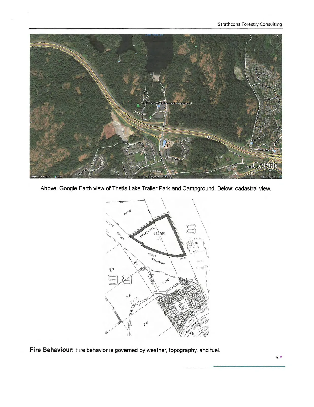
Above: Google Earth view of Thetis Lake Trailer Park and Campground. Below: cadastral view.
Fire Behaviour
Fire behavior is governed by weather, topography, and fuel.
Biogeoclimatic Classification
The subject property is located in the moist maritime Coastal Douglas-fir (CDFmm) biogeoclimatic subzone. Summers are warm and dry, while winters are moist and mild. Growing seasons are long, and often feature pronounced water deficits on zonal (average) and drier sites. Long periods of drought are not uncommon during the fire season (April to October). The CDFmm has the mildest climate in Canada.
Terrain
Physical site characteristics affect fire behavior by affecting ignition potential and the rate of fire spread.
The subject property occupies a southerly to southwesterly aspect on hilly terrain with an elevation range of approximately 40 m. Slopes range from moderate to steep. Lands outside of the property (i.e., slope above the TransCanada Highway, and areas of Thetis Lake Regional Park) contain areas with steep (to > 60%) slopes.
Hilly terrain and warm aspects are significant from a fire behaviour perspective. Fires generally burn hotter on warm aspects. Fires tend to burn uphill.
Vegetation
Fire behavior predicts how forest and wildland fuels (vegetation) will burn under different conditions. Benchmark vegetative fuel types developed by the Canadian Forest Fire Danger Rating System Fire Behavior System (CFFDRS) are used to forecast how a wildfire will react (http://cwfis.cfs.nrcan.gc.ca/en) (refer to Appendix 2).
Major Fuel Types at the subject property include:
Fuel Type C-5: Much of the property is occupied by moderately well stocked stands of older immature to mature, second-growth coniferous forest (dominated by Douglas-fir). Trees crowns are generally separated from the ground; there is a variable amount of ladder fuel loading (aerial fuels such as lower branches on tree boles, and taller shrubs, which could facilitate a surface fire climbing into the tree crowns). Ground cover consists of a combination of scattered shrubs and herbs, and a moderately thick needle litter layer in combination with grass at camping sites. Dried grass in summer can constitute a significant fire risk.
Under certain conditions (warm temperatures with wind, lower humidity), a surface fire start in Fuel Type C-5 could spread rapidly upslope and could climb into tree crowns. The threat of wildfire is increased at the subject property due to the warm aspect and hilly topography.
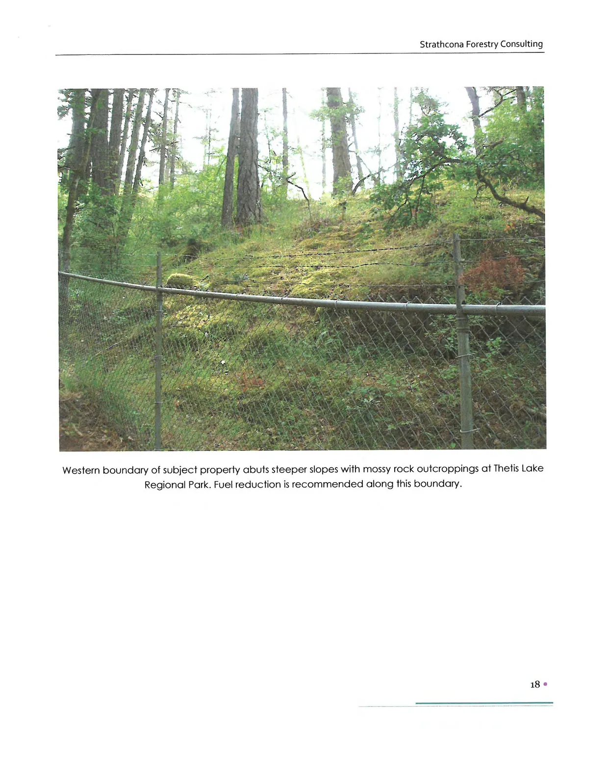
Modified Fuel Type C-1: Several mossy rock outcroppings at the subject property are vegetated with open stands with a sparse herb layer and scattered shrub layer. There is generally a continuous lichen/moss layer.
The potential for surface fires increases in the warmer summer months when ground and surface fuels dry out with full exposure to solar heating.
Mixed (coniferous and deciduous) M-2: Portions of the subject property contain remnant Garry oak woodland/coniferous forest. These fragmented stands have low to moderate downed woody fuels with a moderate shrub layer. Dried surface fuels (leaf layer) can pose a significant fire risk during warmer months.
Manmade Fuels
Manmade fuels at the subject property include existing permanent structures (commercial/recreational/residential) and long-term temporary structures (trailer homes in situ).
Impacts of Proposed Development on Fuel Loading
Trees in the area to be developed as residential will be removed, resulting in a net reduction of woody fuels at the subject area.
New housing will be constructed with fire-resistant exteriors (roofs and siding). New buildings will be more fireproof than those currently existing at the subject site.
Fire Protection
The subject property lies within the service area of View Royal Fire Rescue (VRFR), a composite (partially paid/partially volunteer) fire department which operates from one hall on the Island Highway. The subject property is approximately 2.5 km from View Royal fire hall. Respone time to the Thetis Vale area south of the TransCanada is approximately 4.5 to 5 minutes (VRFR).
Fire department response time is the elapsed time, in minutes, from when the first fire fighting unit is dispatched to when the first fire fighting unit arrives at the emergency scene. Fire department intervention time is crucial in determining the consequences of a fire in terms of deaths, injuries, and loss of property and damage to the environment. An early aggressive and offensive primary interior attack on a working fire is usually the most effective strategy to reduce the loss of lives and property damage. Fire department intervention time is crucial in determining the consequences of a fire in terms of deaths, injuries, and loss of property and damage to the environment. An early aggressive and offensive primary interior attack on a working fire is usually the most effective strategy to reduce the loss of lives and property damage.
Mutual Aid
Fire Departments within CRD fire protection areas operate under a mutual aid agreement with other fire departments within (and outside) the region. In the case of a serious fire, mutual aid from adjoining fire departments (i.e., Langford, Colwood) benefit fire suppression by pooling manpower and resources (water supply, water tenders, etc.,).
Wildfires
CRD Fire Departments automatically respond to structure fires and small, easily accessible bush fires. Assistance from the Wildfire Management Branch is requested when larger brush fires and/or forest fires occur in the area.
Wildfire History
BC’s Wildfire Management Branch maintains a database of human-caused and lightning-caused wildfires. Lightening typically accounts for very few wildfires on Vancouver Island. The majority of wildfires in the Coastal Fire Zone continue to be human-caused. Over the last decade the View Royal Fire Department has worked with the Wildfire Management Branch to suppress several small human-caused fires at Thetis Lake Regional Park. (During the field assessment, I observed occasional old campfires and discarded campsites.)
Water Supply
An adequate and reliable water supply for firefighting is an essential part of a community’s fire protection system. The BC Building Code states all structures (including recreational facilities) within interface areas should have a water supply for firefighting purposes that meets requirements of either the FUS (Fire Underwriters Survey) or the National Fire Protection Association (NFPA). Insurance policies typically cover structures within 300 m of a hydrant, and within 8 km of a fire hall.
In fire protection areas served by a community water system, water supply for fire protection generally consists of a piped system in common with domestic potable water. An adequate and reliable water supply for firefighting is an essential part of a community's fire protection system.
Impacts of Proposed Development on Fireflow
The development will be connected to CRD water. Hydrants will be installed to FUS standards.
Access
FireSmart infrastructure and access increase the resident and firefighter safety, and facilitate quick response by firefighters. Developed properties must have sufficient access for emergency vehicles, including 2-way road access in and out of any site, and safe driveway accesses. Local government standards for roads and driveways generally follow the Geometric Design Guide for Canadian Roads (www.tac-atc).
Narrow, paved, and often hilly driveways access the trailer and camping sites at the eastern portion of the subject property. There is no vehicular access to the wooded, western portion of the property.
Impacts of Proposed Development on Access
New roads to be built in the subdivision will enable fire access to both the site and park area.
Risk of Ignition
The risk of ignition at the subject property ranges between moderate and high. Ignition risk could occur as a result of activities of visitors and residents at the subject property, and/or from recreationalists at nearby Thetis Lake Regional Park, and/or from cigarettes and/or vehicle fires below at the TransCanada Highway. Currently the site operates as a camping/RV area, with visitors arriving somewhat randomly.
Impacts of Proposed Development on Ignition Risk
Open campfires and other sources of combustion will be reduced as a result of subdivision development. Residential development will provide year-round monitoring.
Wildland Urban Interface Wildfire Threat Assessment Results
Scoring from the WUI Wildfire Threat Rating system and associated risk assessment modelling tools indicate the Wildfire Threat at the subject property is High. Under the provincial Wildfire Threat Rating system, high and extreme threat rating levels are unacceptable; ratings must be low or moderate to ensure structure(s) and/or an area is safe. The current rating reflects both biophysical and infrastructure characteristics of the subject property: (warm aspect and hilly topography, the possibility of delayed fire department response times, continuity of forest fuels adjacent to the property, intermix >1 structure/ha, challenging access for emergency vehicles).
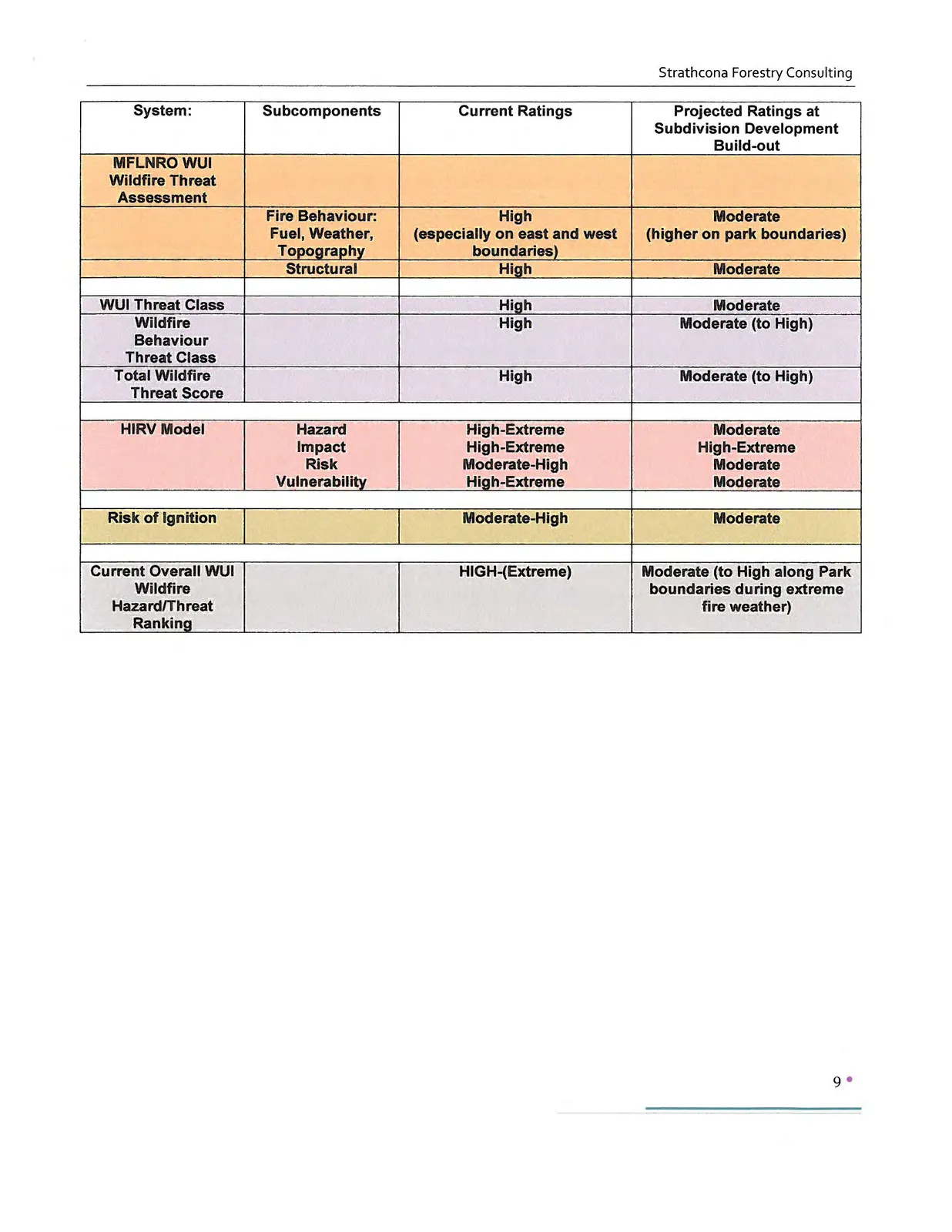
| System | Subcomponents | Current Ratings | Projected Ratings at Subdivision Development Build-out |
|---|---|---|---|
| MFLNRO WUI Wildfire Threat Assessment | |||
| Fire Behaviour: Fuel, Weather, Topography | High (especially on east and west boundaries) | Moderate (higher on park boundaries) | |
| Structural | High | Moderate | |
| WUI Threat Class | High | Moderate | |
| Wildfire Behaviour Threat Class | High | Moderate (to High) | |
| Total Wildfire Threat Score | High | Moderate (to High) | |
| HIRV Model | Hazard Impact Risk Vulnerability | High-Extreme High-Extreme Moderate-High High-Extreme | Moderate High-Extreme Moderate Moderate |
| Risk of Ignition | Moderate-High | Moderate | |
| Current Overall WUI Wildfire Hazard/Threat Ranking | HIGH-(Extreme) | Moderate (to High along Park boundaries during extreme fire weather) |
Recommendations to Reduce the Wildfire Threat
Strategies to prevent wildfire typically include FireSmart vegetation management, construction options, and infrastructure improvements. The following strategies were developed in response to a proposed residential development proposal at the subject property.
Precautions During Land Clearing and Construction
- Ensure any land clearing activities are conducted in compliance with BC’s Wildfire Act local bylaws.
- As per the BC Wildfire Act, if a high risk activity (i.e., land clearing) is taking place between 1 April and 31 October, the operator must keep at the activity site fire fighting hand tools, in a combination and type to properly equip each person who works at the site with a minimum of one fire fighting hand tool, and an adequate fire suppression system (onsite portable water tanker and fire fighting tools – shovels, pulaskis, portable water backpacks). In addition, efforts must be made to maintain an adequate fire break between any high risk activity and areas of continuous forest to ensure a fire originating at the site does not escape the site.
- Develop an Emergency Plan of Action, listing key contact information in case of fire and/or other emergency at the site.
- Hazard abatement (removal of slash/disposal of debris piles) must take place in compliance with Town of View Royal bylaws.
- Ensure construction workers are made aware of the risk of fire in the interface zone, especially during a dry summer season. Smoking should be banned by workers during high/extreme fire weather.
Vegetation Management
10 m FireSmart Priority Zone around all homes and structures
- Establish and maintain a FireSmart Priority Zone 0-10 m (see Appendix 1)
- around existing and any new structures bordering continuous forest
- along the western and eastern boundaries of the subject property, next to Thetis Lake Regional Park.
Recommended actions:
- Under direction of a forestry professional with experience in fuel reduction, reduce/remove woody fuels.
- Prior to commencement of work, conduct a Hazard Tree assessment to ensure the safety and stability of any suspect and/or wildlife trees to be retained within 1½ tree lengths of any structures and/or mutual boundary.
- Conduct a light understorey thinning combined with removal of surface fuels (broom, etc.), dead suppressed stems, and downed, aerial woody fuels. Retain healthy, well-spaced understorey. Large downed woody fuels should be bucked in short (0.3 m) lengths and left to decay at ground level.
- Plan to retain older immature and mature trees that are:
- well-spaced (ideally, crowns have at least 3 m separation),
- pruned (lower branches pruned to at least 3.5 m height from ground).
- Favour widely-spaced (> 3 m crown separation), slow-growing deciduous and/or broad-leaved native trees (i.e., arbutus), as these types of trees typically are not as combustible as coniferous species.
- Limit the use of any coniferous hedges and wooden fences around structures along forested boundaries, as these features could act as a conduit for fire. Low wooden fences are acceptable, providing there is a separation of at least 3 m between the fence and any structure.
- Develop a FireSmart landscaping plan by incorporating fire-resistive native shrubs and groundcover in combination with fire-resistant landscape features (mowed lawns, landscape tiles, water features). See FireSmart Landscaping on Southeastern Vancouver Island (brochure), Strathcona Forestry Consulting. http://www.cityoflangford.ca/documents/brochures/FireSmartLandscaping.pdf
- Regularly remove invasive plants (broom, thistle, etc.). Dried broom is very combustible under certain conditions (i.e., warm dry summers).
- Any areas of soil disturbance should be promptly re-vegetated with approved landscaping materials and/or native plant species to prevent encroachment from invasive plant species.
- Consult with Capital Regional District Parks regarding fuel management treatment along mutual boundaries. Plan to conduct vegetation management using the park road downslope from the subject property’s eastern boundary.
Construction Options (applicable to new construction and renovations)
- Use fire-retardant roof covering assemblies rated Class A, B, or C (i.e., metal, tile, ULC- rated asphalt) and feature non-combustible siding materials (i.e., stucco, metal siding, brick, cement shingles or cementitious materials, poured concrete, or ULC-rated wood siding) on new residences and outbuildings.
- Follow FireSmart guidelines for design, construction, and maintenance of window and door glazing, eaves and vents, and decking http://www.partnersinprotection.ab.ca
- Ensure structures are equipped with working smoke alarm(s).
- Strictly enforce campfire bans during extreme fire weather.
Access and Fireflow
- Ensure any development of new access routes complies with local government standards and follows the Geometric Design Guide for Canadian Roads (www.tac-atc).
- Ensure street addresses are clearly evident. Letters, numbers, and symbols should be at least 10 cm high, with a 12 mm stroke, contrast with the background colour of the sign, and be reflective.
- Ensure fire turnarounds are sufficiently wide to accommodate emergency vehicles.
- Ensure all structures are mapped on VRFR “pre-org” (fire planning) maps.
- Facilitate an emergency access plan with Capital Regional District Parks for pedestrian egress in the case of emergency.
- Follow standard FUS and Town of View Royal specifications for water lines and type and spacing of fire hydrants.
Regulatory Provisions
- If new construction if implemented, conduct a follow-up assessment (at building permit) to ensure appropriate mitigation measures have been implemented.
Summary
As part of a rezoning application, Limona Construction Ltd., Strathcona Forestry Consulting assessed the Wildfire Interface (Wildfire Threat) Rating at the Thetis Lake Trailer Park and Campground. The assessment was done in response to a proposed residential development proposal, which includes a residential area and large area of park dedication. The CURRENT Wildfire Threat Rating is High due to a combination of factors: warm aspect and hilly terrain; narrow, winding, hilly roads for emergency response vehicles; proximity and continuity of adjacent fuel loading at Thetis Lake Regional Park; and an elevated risk of ignition potentially arising from local residents/visitors, and/or visitors to the adjacent Thetis Lake Regional Park.
The projected Wildfire Threat Rating at build-out of the development is anticipated to be Moderate. Woody fuel loading will be reduced as a result of clearing for development. New residential units will be constructed with fire-resistant exteriors. The development will be connected to a community water system, and will have hydrants meeting FUS standards. Risk of ignition will be reduced as a result of year-round monitoring by permanent residents.
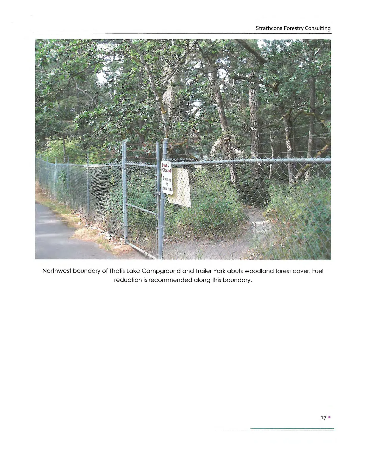
This report contains FireSmart strategies to reduce wildfire. The strategies target vegetation management, construction options, and infrastructure improvements. As noted in the preceding paragraph, many of these issues will be addressed by the proposed residential development. Vegetation management should be an ongoing strategy in the wildfire interface zone. Fuel reduction is recommended along boundaries between the subject property and Thetis Lake Regional Park.
Fire prevention and protection in the interface zone are ongoing processes. Long-term implementation of FireSmart mitigation is essential to ensure protection for life, property, and ecological processes in View Royal’s wildland urban interface.
Appendix 1. FireSmart Interface Priority Zones
In interface areas, FireSmart advocates the establishment and maintenance of Fuel Management Zones* extending outward from structures and along access routes: Priority Zone 1 (0-10 m). Priority Zone 2 (10-30 m). Priority Zone 3 (30-100 m).
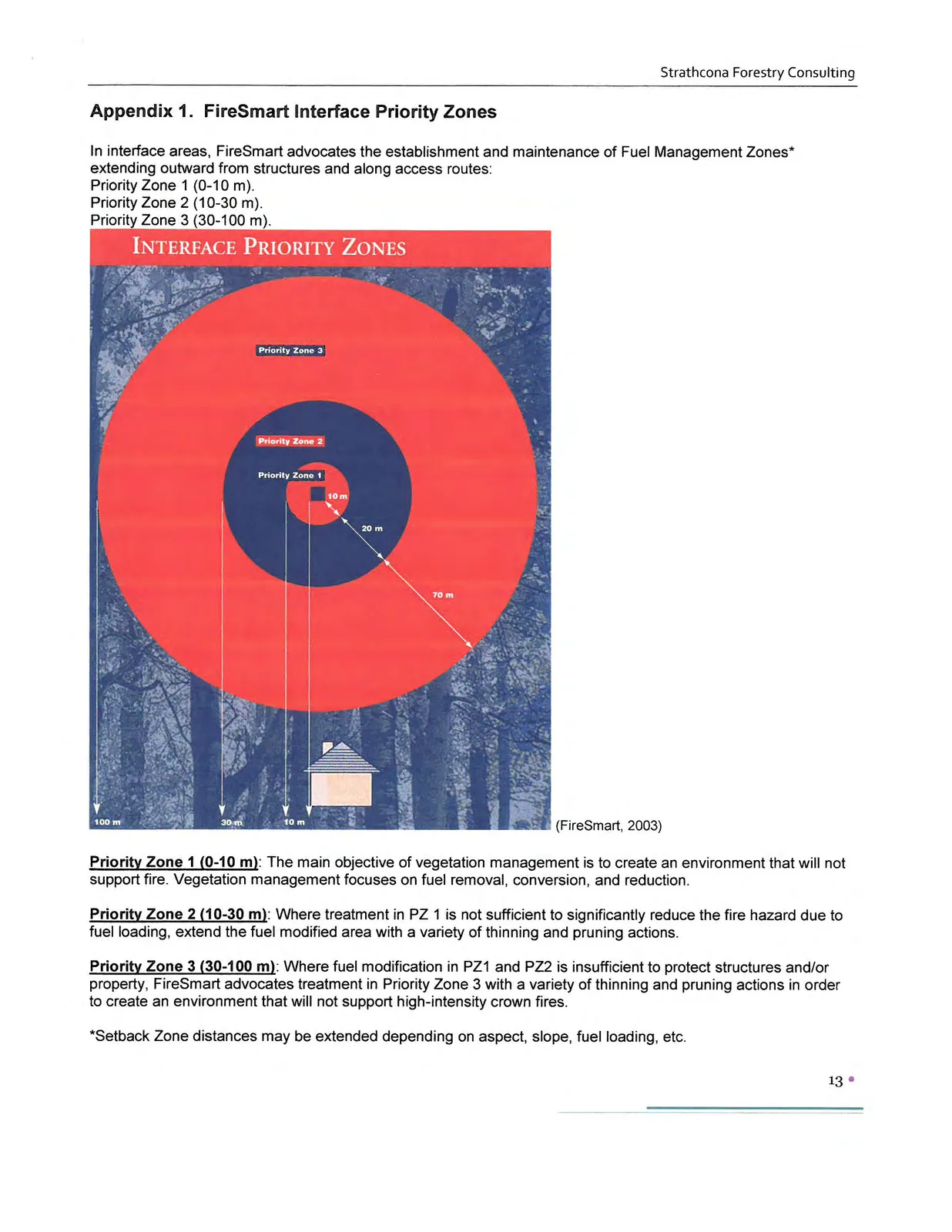
Priority Zone 1 (0-10 m): The main objective of vegetation management is to create an environment that will not support fire. Vegetation management focuses on fuel removal, conversion, and reduction.
Priority Zone 2 (10-30 m): Where treatment in PZ 1 is not sufficient to significantly reduce the fire hazard due to fuel loading, extend the fuel modified area with a variety of thinning and pruning actions.
Priority Zone 3 (30-100 m): Where fuel modification in PZ1 and PZ2 is insufficient to protect structures and/or property, FireSmart advocates treatment in Priority Zone 3 with a variety of thinning and pruning actions in order to create an environment that will not support high-intensity crown fires.
*Setback Zone distances may be extended depending on aspect, slope, fuel loading, etc.
Appendix 2. Generic Fuel Types (adopted from CFFDRS)
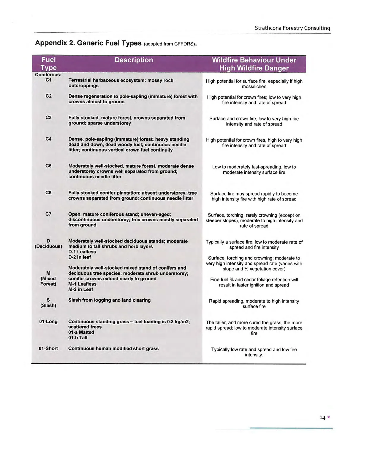
| Fuel Type | Description | Wildfire Behaviour Under High Wildfire Danger |
|---|---|---|
| Coniferous: | ||
| C1 | Terrestrial herbaceous ecosystem: mossy rock outcroppings | High potential for surface fire, especially if high moss/lichen |
| C2 | Dense regeneration to pole-sapling (immature) forest with crowns almost to ground | High potential for crown fires; low to very high fire intensity and rate of spread |
| C3 | Fully stocked, mature forest, crowns separated from ground; sparse understorey | Surface and crown fire, low to very high fire intensity and rate of spread |
| C4 | Dense, pole-sapling (immature) forest, heavy standing dead and down, dead woody fuel; continuous needle litter; continuous vertical crown fuel continuity | High potential for crown fires, high to very high fire intensity and rate of spread |
| C5 | Moderately well-stocked, mature forest, moderate dense understorey crowns well separated from ground; continuous needle litter | Low to moderately fast-spreading, low to moderate intensity surface fire |
| C6 | Fully stocked conifer plantation; absent understorey; tree crowns separated from ground; continuous needle litter | Surface fire may spread rapidly to become high intensity fire with high rate of spread |
| C7 | Open, mature coniferous stand; uneven-aged; discontinuous understorey; tree crowns mostly separated from ground | Surface, torching, rarely crowning (except on steeper slopes), moderate to high intensity and rate of spread |
| D (Deciduous) | Moderately well-stocked deciduous stands; moderate medium to tall shrubs and herb layers D-1 Leafless D-2 In leaf | Typically a surface fire; low to moderate rate of spread and fire intensity. Surface, torching and crowning; moderate to very high intensity and spread rate (varies with slope and % vegetation cover) |
| M (Mixed Forest) | Moderately well-stocked mixed stand of conifers and deciduous tree species; moderate shrub understorey; conifer crowns extend nearly to ground M-1 Leafless M-2 in Leaf | Fine fuel % and cedar foliage retention will result in faster ignition and spread |
| S (Slash) | Slash from logging and land clearing | Rapid spreading, moderate to high intensity surface fire |
| 01-Long | Continuous standing grass – fuel loading is 0.3 kg/m2; scattered trees 01-a Matted 01-b Tall | The taller, and more cured the grass, the more rapid spread; low to moderate intensity surface fire |
| 01-Short | Continuous human modified short grass | Typically low rate and spread and low fire intensity. |
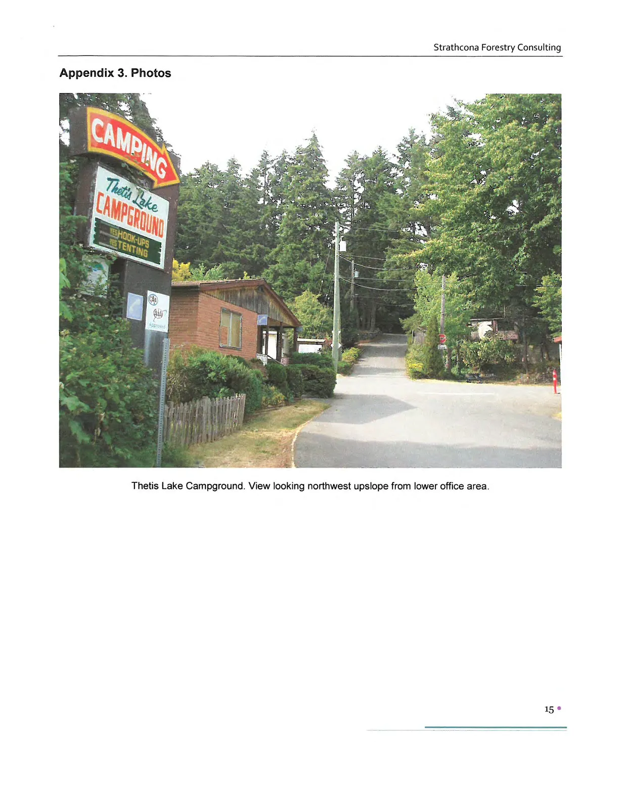
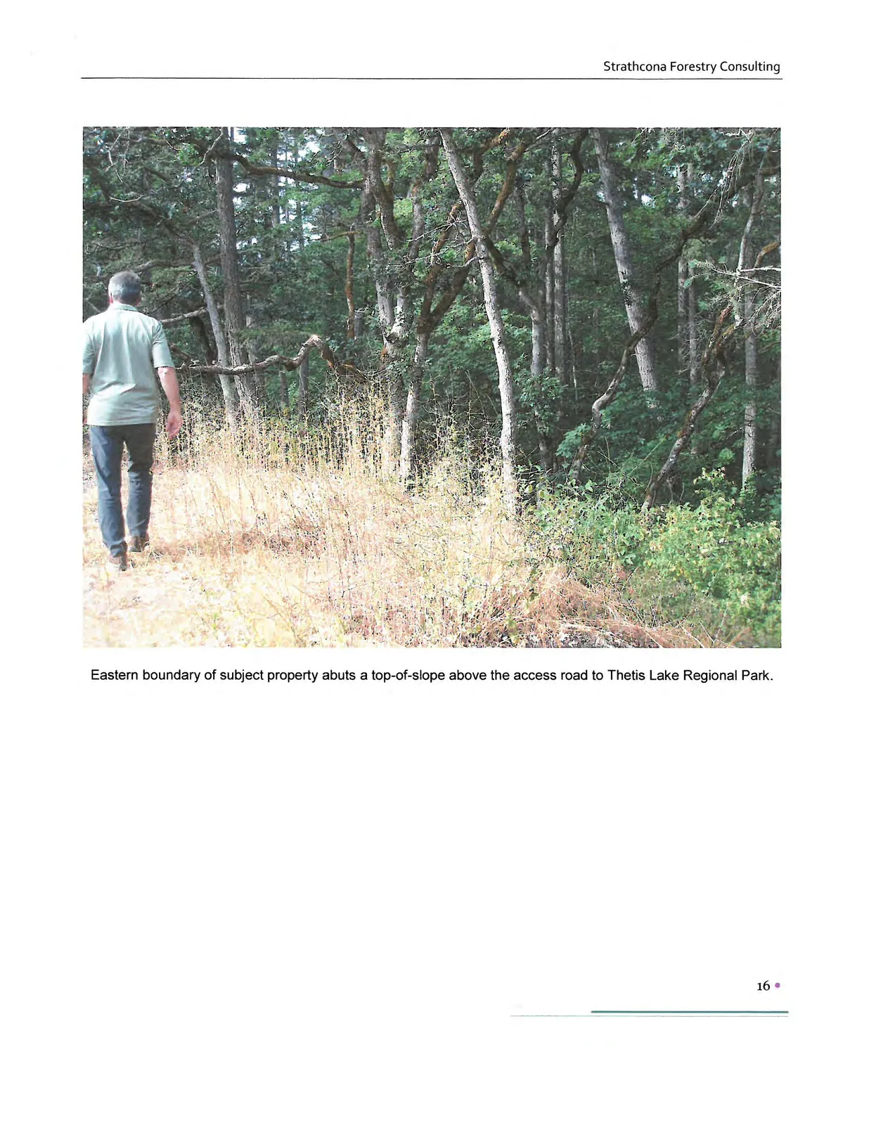
Appendix 3. Photos
Limitations
This report provides an assessment of WUI hazard and risk. Evaluation is based on professional judgment. The investigation involved a field observation. Recommended treatment pertains only to the particular site as disclosed at the time of inspection. The report was prepared considering site-specific circumstances and conditions. It is intended only for use by the client for the purpose for which it was commissioned and for use by local government regulating the activities to which it pertains.
Document Images
(9)