Council Meeting/Documents/B.C. Land Surveyor's Proposed Subdivision of That Part of Lot E, Section 3, Esquimalt District... (18 Fenton Road)
Appendix
B.C. Land Surveyor's Proposed Subdivision of That Part of Lot E, Section 3, Esquimalt District... (18 Fenton Road)
June 6, 2017Page 271 section
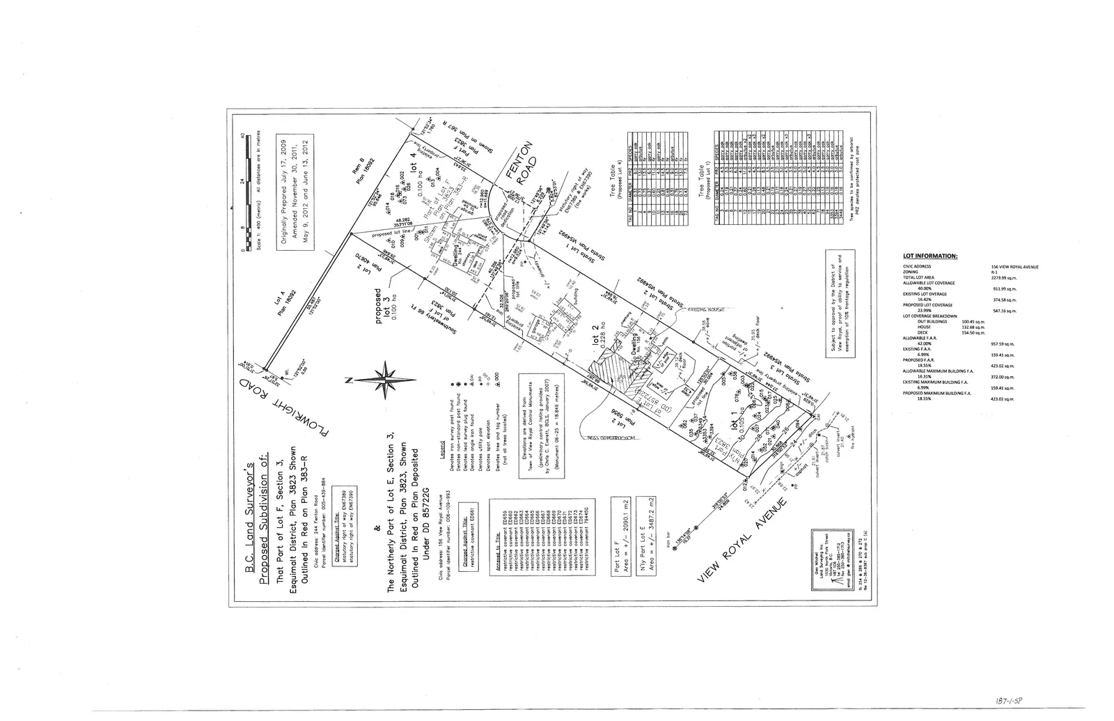
Detailed site plan and survey for the property related to the floor area variance request.
Address: 156 View Royal Avenue (linked to 18 Fenton Road application)Survey Date: Originally May 2009, amended June 2012
B.C. Land Surveyor's Proposed Subdivision of: That Part of Lot F, Section 3, Esquimalt District, Plan 3823 Shown Outlined In Red on Plan 383-R & The Northerly Part of Lot E, Section 3, Esquimalt District, Plan 3823, Shown Outlined In Red on Plan Deposited Under DD 85722G
General Information
- Civic Address (Fenton Road): 244 Fenton Road
- Parcel identifier number: 005-439-884
- Civic Address (View Royal Avenue): 156 View Royal Avenue
- Parcel identifier number: 006-019-993
- Scale: 1:400 (metric). All distances are in metres.
- Dates:
- Originally Prepared: July 17, 2009
- Amended: November 30, 2011; May 9, 2012; June 13, 2012.
Legend
- ● Denotes iron survey post found
- ○ Denotes non-standard post found
- + Denotes lead survey plug found
- □ Denotes single iron found
- ⌖ Denotes utility pole
- ⑇ Denotes hydrant
- # Denotes tree and tag number (not all trees located)
Interest on Title
- restrictive covenant ED651
- restrictive covenant ED652
- restrictive covenant ED653
- restrictive covenant ED654
- restrictive covenant ED655
- restrictive covenant ED656
- restrictive covenant ED657
- restrictive covenant ED658
- restrictive covenant ED659
- restrictive covenant ED660
- restrictive covenant ED671
- restrictive covenant ED672
- restrictive covenant ED673
- restrictive covenant ED674
- restrictive covenant ED675
- restrictive covenant 7942G
Elevations
Elevations are derived from Town of View Royal Control Monuments by differential leveling (BCS 2007) to GRS 80 (Ellipsoid GRS 80, January 2007) (Monument 06-25 = 18.849 metres).
Area Information
- Port Lot F: Area = +/- 2090.1 m²
- Nly Port Lot E: Area = +/- 1387.2 m²
Lot Information
| Description | Details |
|---|---|
| CIVIC ADDRESS | 156 VIEW ROYAL AVENUE |
| ZONING | R-1 |
| TOTAL LOT AREA | 2279.99 sq.m. |
| ALLOWABLE LOT COVERAGE 40.00% | 911.99 sq.m. |
| EXISTING LOT COVERAGE 16.42% | 374.58 sq.m. |
| PROPOSED LOT COVERAGE 23.99% | 547.16 sq.m. |
| LOT COVERAGE BREAKDOWN | |
| OUT BUILDINGS | 100.45 sq.m. |
| HOUSE | 132.68 sq.m. |
| DECK | 154.50 sq.m. |
| ALLOWABLE F.A.R. 42.00% | 957.59 sq.m. |
| EXISTING F.A.R. 6.99% | 159.41 sq.m. |
| PROPOSED F.A.R. 18.55% | 423.02 sq.m. |
| ALLOWABLE MAXIMUM BUILDING F.A. 16.31% | 372.00 sq.m. |
| EXISTING MAXIMUM BUILDING F.A. 6.99% | 159.41 sq.m. |
| PROPOSED MAXIMUM BUILDING F.A. 18.55% | 423.02 sq.m. |
Tree Table (Proposed Lot 4)
| TAG NO. | SPECIES | SIZE | CONDITION |
|---|---|---|---|
| 3 | GARRY OAK | 0.28 | GOOD |
| 4 | GARRY OAK | 0.23 | GOOD |
| 5 | GARRY OAK | 0.44 | GOOD |
| 6 | GARRY OAK | 0.23 | GOOD |
| 7 | GARRY OAK | 0.48 | GOOD |
| 8 | GARRY OAK | 0.27 | GOOD |
| 9 | GARRY OAK | 0.23 | GOOD |
| 10 | GARRY OAK | 0.41 | GOOD |
| 11 | GARRY OAK | 0.24 | GOOD |
| 12 | GARRY OAK | 0.46 | GOOD |
| 13 | GARRY OAK | 0.23 | GOOD |
| 14 | GARRY OAK | 0.47 | GOOD |
| 15 | GARRY OAK | 0.14 | FAIR |
Tree Table (Proposed Lot 1)
| TAG NO. | SPECIES | SIZE | CONDITION |
|---|---|---|---|
| 1 | GARRY OAK | 0.48 | GOOD |
| 2 | GARRY OAK | 0.35 | GOOD |
| 17 | GARRY OAK | 0.34 | GOOD |
| 18 | GARRY OAK | 0.47 | GOOD |
| 19 | GARRY OAK | 0.37 | GOOD |
| 20 | GARRY OAK | 0.12 | FAIR |
| 21 | GARRY OAK | 0.27 | GOOD |
| 22 | GARRY OAK | 0.52 | GOOD |
| 23 | GARRY OAK | 0.45 | GOOD x2 |
| 24 | GARRY OAK | 0.31 | FAIR |
| 25 | GARRY OAK | 0.51 | GOOD |
| 26 | GARRY OAK | 0.24 | FAIR |
| 27 | GARRY OAK | 0.41 | GOOD |
| 28 | GARRY OAK | 0.55 | GOOD |
| 29 | GARRY OAK | 0.46 | GOOD x3 |
| 30 | GARRY OAK | 0.22 | FAIR |
| 31 | GARRY OAK | 0.41 | GOOD |
| 32 | GARRY OAK | 0.35 | GOOD x2 |
| 33 | GARRY OAK | 0.38 | GOOD |
| 34 | GARRY OAK | 0.31 | GOOD x2 |
| 35 | GARRY OAK | 0.27 | GOOD |
| 36 | GARRY OAK | 0.21 | GOOD x2 |
| 37 | GARRY OAK | 0.25 | GOOD x2 |
| 38 | GARRY OAK | 0.42 | GOOD |
| 39 | GARRY OAK | 0.31 | GOOD |
| 1048 | GARRY OAK | 1.05 | GOOD |
Note: Tree species to be confirmed by arborist. PNZ denotes protected root zone.
Notes
Subject to approval by the District of View Royal, proof of ability to service and exemption of 10% frontage regulation.
Page 27
Extracted from: 2017 06 06 Council Agenda - Agenda - Pdf