Appendix
LANDSCAPE MASTERPLAN - CHRISTIE POINT
June 13, 2017Page 1501 section
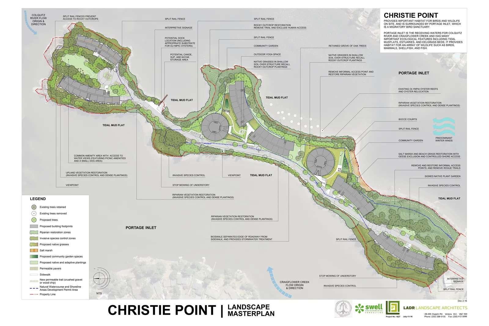
Illustrative masterplan showing proposed landscape features including trails, viewpoints, and restoration zones.
Location: Portage InletFeatures: Community garden, tidal mud flats, bouldering area
CHRISTIE POINT | LANDSCAPE MASTERPLAN
Christie Point Description
CHRISTIE POINT PROVIDES IMPORTANT HABITAT FOR BIRDS AND WILDLIFE ON SITE, AND IS SURROUNDED BY PORTAGE INLET, WHICH IS A MIGRATORY BIRD SANCTUARY.
PORTAGE INLET IS THE RECEIVING WATERS FOR COLQUITZ RIVER AND CRAIGFLOWER CREEK AND HAS MANY IMPORTANT ECOLOGICAL FEATURES INCLUDING TIDAL MUDFLATS, ESTUARIES, AND EELGRASS BEDS. IT PROVIDES HABITAT FOR AN ARRAY OF WILDLIFE SUCH AS BIRDS, MAMMALS, SHELLFISH, AND FISH.
Legend
- Existing trees retained
- Existing trees removed
- Proposed trees
- Proposed building footprints
- Riparian restoration zones
- Invasive species control zones
- Proposed native grasses
- Salt marsh
- Proposed community garden spaces
- Proposed native and adaptive plantings
- Permeable pavers
- Sidewalk
- New permeable trail (crushed gravel or wood chip)
- Natural Watercourse and Shoreline Areas Development Permit Area
- Property Line
Masterplan Annotations
- Colquitz River flow origin & direction
- Split rail fences prevent access to rocky outcrops
- Split rail fence
- Interpretive signage
- Potential dock location (including appropriate substrate for Olympic oysters)
- Potential canoe, SUP, and kayak storage area
- Tidal mud flat
- Rocky outcrop restoration: Remove trail and exclude human access
- Community garden
- Outdoor yoga space
- Native grasses in shallow soil over structure recall rocky outcrop plantings
- Retained grove of oak trees
- Remove informal access point and restore riparian vegetation
- Portage Inlet
- Existing Olympia oyster reefs and oyster relocation
- Riparian vegetation restoration (invasive species control and dense plantings)
- Bocce courts
- Predominant winter winds
- Salt marsh and beach grass restoration with geese exclusion and controlled shore access
- Remove and restore informal access points, and remove rogue trails
- Signed native plant garden
- Invasive species control
- Stop mowing of understory
- Craigflower Creek flow origin & direction
- Bioswale separates edge of roadway from sidewalk, and provides stormwater treatment
- Viewpoint
- Upland vegetation restoration (invasive species control and dense plantings)
- Common amenity area with access to water views (featuring picnic amenities and a small dog area)
Project Information
- Project No: 1627
- Date: July-11-16
- Revised: Dec 2-16
- Firm: LADR LANDSCAPE ARCHITECTS
- Address: 28-495 Dupplin Rd. Victoria B.C. V8Z 1B8
- Phone: (250) 598-0105
- Fax: (250) 412-0896
Page 150
Extracted from: 2017 06 13 Special Council Meeting Agenda - Agenda - Pdf