TOWN OF VIEW ROYAL BYLAW NO. 976
A bylaw to create the CD-22 (Christie Point Residential) zone and rezone the property at 2951 Craigowan Road.
TOWN OF VIEW ROYAL BYLAW NO. 976
A BYLAW TO AMEND THE TOWN OF VIEW ROYAL ZONING BYLAW WITH RESPECT TO CREATING THE CD-22 (CHRISTIE POINT RESIDENTIAL) ZONE AND WITH RESPECT TO THE REZONING OF 2951 CRAIGOWAN RD (CHRISTIE POINT)
The Council of the Town of View Royal, in open meeting assembled, enacts as follows:
- This Bylaw may be cited as "Zoning Bylaw, 2014, No. 900, Amendment Bylaw No. 976, 2017”.
- Bylaw No. 900 is hereby amended by adding the following Zone Table immediately after the “CD-21: Detached Multiple-Unit Residential” Zone Table:
CD-22: Christie Point Residential
Principal Uses
- Residential, Apartment
- Residential, Townhouse
Accessory Uses
- Home Occupation
| CD-22: Christie Point Residential | |
|---|---|
| Lot Size | |
| Lot Size, minimum | 63,050m² |
| Lot Density | |
| Floor Space Ratio | 1.15 |
| Lot Coverage, maximum | 35% |
| Impermeable Surface Coverage, maximum | 40% |
| Size of Principal Buildings and Other Structures | |
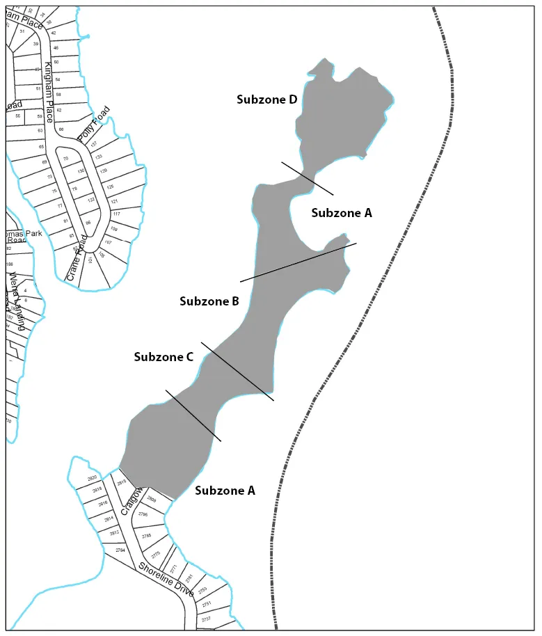
| Building Height, maximum (Subzone A) | 26m |
| Building Height, maximum (Subzone B) | 24.5m |
| Building Height, maximum (Subzone C) | 24m |
| Building Height, maximum (Subzone D) | 18m |
| Building Width, minimum | 6m |
| Floor Plate Maximum | |
| Top Storey Floor Space, maximum (Subzones A, B, C) | 85% of floor space of storey immediately below |
| Siting of Buildings and Other Structures (Principal and Accessory) | |
| All lot lines setback, minimum | 15m |
| Siting of Buildings and Other Structures (Principal and Accessory) | |
| Minimum geodetic elevation of habitable areas | 3.5m |
| Minimum geodetic elevation of underground or concealed parking entrances | 3.0m |
- Schedule "B" Zoning Map referred to in Section 1.7 of Zoning Bylaw, 2014, No. 900, is amended by amending the zoning and zoning boundaries for lands legally described as follows:
PART OF SECTION 2, ESQUIMALT DISTRICT, LYING TO THE NORTH OF PLAN 40 RW TO THE EAST OF THE RIGHT OF WAY OF THE ESQUIMALT AND NANAIMO RAILWAY COMPANY AND TO THE WEST OF PLAN 10960, EXCEPT PARTS IN PLANS 11627, 11919 AND 41826
which is currently zoned RM-1: Ground-Oriented Multiple-Use Residential such that the zoning for the aforementioned properties is established as follows:
a. The lands as shown shaded on the sketch plan of attached hereto and forming part of this Bylaw as Schedule ‘1’ are zoned CD-22: Christie Point Residential
READ A FIRST TIME THIS _______DAY OF _______, 2017.
READ A SECOND TIME THIS _______DAY OF _______, 2017.
APPROVED BY THE MINISTRY OF TRANSPORTATION AND INFRASTRUCTURE THIS _______DAY OF _______, 2017.
PUBLIC HEARING HELD THIS THIS _______DAY OF _______, 2017.
READ A THIRD TIME THIS ________ DAY OF ________, 2017.
ADOPTED BY COUNCIL, SIGNED BY THE MAYOR AND THE CLERK AND SEALED WITH THE SEAL OF THE TOWN OF VIEW ROYAL THIS THIS ________DAY OF ________, 2017.
MAYOR
CLERK
Schedule 1
AMENDMENTS TO Schedule "2" Zoning Map of Zoning Bylaw, 2014, No. 900
Document Images
(1)