BC Transit Island Highway Transit Priority Plan and Park & Ride Study - Final Report
A comprehensive technical study providing concept designs and traffic simulations for transit priority measures and park and ride facilities along the Island Highway.
BC TRANSIT
Island Highway Transit Priority Plan and Park & Ride Study
FINAL REPORT
REVISION A1
Submitted to: BC Transit 520 Gorge Road East Victoria BC V8W 9T5
Submitted by: SNC-Lavalin Inc. Suite 500 - 745 Thurlow Street Vancouver, BC, Canada, V6E 0C5
Contents
1.0 Introduction and Context 1.1 Introduction 1.2 Capital Region Context 1.3 Current Status 2.0 Existing Conditions 2.1 Jurisdictional Responsibilities 2.2 Design Classification 2.3 Alignment and Profile 2.4 Roadway Cross Section 2.5 Major Structures 2.6 Right-of-Way and Utilities 2.7 Private Access and Adjacent Land Use 2.8 Traffic Controls and Auxiliary Lanes 2.9 Transit Service and Facilities 2.10 Cycling Facilities 2.11 Pedestrian Facilities 2.12 BC Transit & Municipal Operational Concerns 3.0 Traffic Volumes and Travel Times 3.1 Traffic Volumes 3.2 Corridor Passenger Volume 3.3 General Traffic Travel Time 3.4 Corridor Travel Speeds and Congestion Zones 3.5 Bus Travel Times 4.0 Transit Priority Options 4.1 Development of Candidate NB and SB Transit Priority Options 4.2 Analysis and Evaluation of Candidate Transit Priority Options 4.3 2018 Exiting Conditions Simulation Results 4.4 Transit Priority Measures Simulation Results 5.0 Potential Construction Packages and Budget Estimates 5.1 Potential Construction Packages 5.2 Construction Cost Estimate 5.3 Project Budget 6.0 Option Evaluation
Part 2 - Park & Ride Study
7.0 Existing Park & Ride Facilities 7.1 Existing Park & Ride Supply 7.2 Park & Ride Demand Forecast Model 7.3 Park & Ride Demand Estimates 7.4 Identification and Evaluation of Potential Park & Ride Location Options 7.5 Conceptual Park & Ride Layout & Construction Cost
Part 1 – Island Highway Transit Priority Study
1.0 Introduction and Context
1.1 Introduction
In November 2017 BC Transit retained SNC-Lavalin Inc. (SLI) to conduct the Island Highway Transit Priority and Park & Ride Study with the objective of developing concept designs and cost estimates for future transit priority measures on the Island Highway and Park & Ride facilities that support the functional needs of BC Transit, the City of Colwood and the Town of View Royal. This objective supports BC Transit’s overall goals, including:
- Identifying and implementing transit priority measures that will improve transit performance in terms of transit travel times and schedule reliability;
- Identifying and implementing measures that will improve the mode share for transit along the corridor,
- Furthering the development of a rapid bus corridor along the proposed long term rapid transit alignment,
- Implementing the measures of the Transit Future Plan
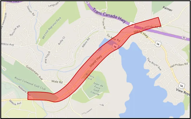
The study area for the transit priority study extends from the signals at the Colwood Hwy 1 Interchange in a southerly direction to the unsignalized T-junction at Sooke Rd. and Jerome Rd., a distance of about 2.6 km from the Colwood Interchange signals.
Figure 1.1 (next page) illustrates the extent of the study area.
1.2 Capital Region Context
BC Transit has developed long term (25 year) transit plans, known as a Transit Future Plans, for many of the Regions throughout British Columbia.
The Victoria Region Transit Future Plan, approved by the Victoria Regional Transit Commission (VRTC) in May 2011, provides a vision for transit over the next 25 years to support the economic, social and environmental sustainability goals of the region. The Transit Future Plan was based on local government land use and transportation plans including the Regional Growth Strategy, the Regional Transportation Plan and, and Official Community Plans and the plan is still relevant today with progress being made to implement new services and infrastructure. The Plan identifies a transit network with a hierarchy of services including Rapid Transit, Frequent Transit, Local Transit and Targeted Transit services as well as a strategic list of initiatives to improve transit services. A Westshore Local Area Transit Plan was completed in 2015 providing further guidance to develop capital and service planning initiatives.
One of the key priorities of the Transit Future Plan was to develop a rapid and frequent transit network. In particular, five corridors were identified as part of the long-term plan for the provision of rapid transit services and dedicated facilities – Douglas Street, Highway 1, Island Highway, McKenzie Avenue and Highway 17.
1.3 Current Status
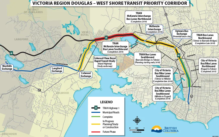
Bus lanes have been partially implemented on Douglas Street and are in the process of being implemented on Highway 1. This study is to identify options for transit priority along Island Highway and supportive Park & Ride improvements. If supported by local governments and the VRTC the projects could receive funding to move forward with design and construction.
Figure 1.2 presents an overview of the Douglas Corridor – West Shore transit priority improvements under development and being implemented.
2.0 Existing Conditions
Transit, cycling, pedestrian and general automobile operations and infrastructure conditions were reviewed along an ~3 km section of the Island Highway corridor extending from the signals at Colwood Hwy 1 Interchange, in a southerly direction to the vicinity of the intersection of Sooke Rd. and Jerome Rd. The following sections were also included:
- Approximately 400 m of Sooke Rd. from the intersection at Jerome Rd. to the signalized intersection at Sooke Rd. and University Dr. (Royal Roads University) at the southern end of the corridor.
- Approximately 350 m of Burnside Rd W between the end of the westbound off ramp from Hwy 1 to the Colwood interchange signals at the northern end of the section.
The road names encountered along the corridor under review include:
- Burnside Rd W for 0.35 km north of the Colwood Interchange signals
- Island Highway from the Colwood Interchange signals to Goldstream Ave
- Sooke Rd from Goldstream Ave to University Dr (Royal Roads University)
The purpose of the existing conditions review was to:
- Document the condition of the transportation related infrastructure in place along the island Highway corridor.
- Provide a brief summary of information gathered from conversations with BC Transit staff and operators and Municipal staff on their perceptions of operational and safety problems along the corridor.
- Observe and document the problems & challenges in both the northbound (NB) and southbound (SB) directions along the corridor that potentially impact transit performance.
2.1 Jurisdictional Responsibilities
Burnside Rd West between the Colwood Hwy 1 Interchange and Watkiss Rd is under the jurisdiction of the BC Ministry of Transportation and Infrastructure (BCMoTI). This includes the ~350 m section referred to above. This section currently has full access control.
Island Hwy between the Colwood Interchange and the View Royal/Colwood municipal boundary south of Wilfert Rd is under the jurisdiction of the Town of View Royal. It is shown in their Official Community Plan (OCP), Land Use Designations, to be located within extensive areas designated for urban land use; and is classified as a Major Road.
Between the View Royal/Colwood municipal boundary south of Wilfert Rd and University Dr, the Island Hwy and Sooke Rd are under the jurisdiction of the City of Colwood. In their Official Community Plan (OCP), Land Use Designations, Island Highway and Sooke Rd. are located within extensive areas designated for urban land use; and are classified in the 2015 Transportation Master Plan as Arterial Roads. The Transportation Master Plan states “Arterial Roads are intended for longer-distance regional mobility and facilitate higher vehicle speeds, often are more than two lanes of vehicle traffic and support regional connections”.
2.2 Design Classification
Throughout the entire 3.35 km multi modal transportation corridor, consisting of sections of Burnside Rd West, the Island Highway and Sooke Rd, four basic travel lanes are currently provided, each of minimum width ~ 3.5 m, with a posted speed of 50 km/h. Within the Colwood Interchange, Burnside Rd W is divided with a grassed or curbed median. From the Colwood Interchange to Goldstream Ave, the Island Hwy is divided with either a flush median (width ~4.8 m) or a curbed median, both providing shelter for left turning vehicles. From south of Goldstream Ave to University Dr, Sooke Rd is undivided, but left turn lanes are provided at the University Dr. / Aldeane Ave. signals. In consideration of the jurisdictional responsibilities outlined previously; urban land use designations; road classifications; existing roadway infrastructure; and posted speed, SLI concludes that the roadway portion of the multimodal corridor can be given a Transportation Association Of Canada (TAC) 2017 Geometric Design Guide for Canadian Roads Design Classification of 4-lane Urban Arterial, either Divided or Undivided, i.e. UAD 50 or UAU 50. In planning for transit priority measures this classification will be helpful for a number of reasons including:
- Reflecting the need within the corridor to primarily provide for the movement of all modes of through traffic including transit, and the general intention to minimize direct land access.
- Providing a guide for the geometric criteria to be utilized for any multimodal transportation improvements within the corridor associated with the implementation of transit priority measures.
2.3 Alignment and Profile
Although it has a number of horizontal curves, the horizontal alignment of the Island Hwy/Sooke Rd is generally gentle enough to be driven comfortably at 50 km/h when dry and well lit. Exceptions occur where drivers need to be particularly alert as follows:
- Across the curving Parsons Bridge (right hand curve in the SB direction) just south of 6-Mile Rd, where the Island Hwy SB lanes are constrained within the confines of the raised median and parapet railings of the bridge. The NB lanes are not quite as constrained, since there is a flush shoulder on the left and a shoulder bike lane on the right.
- Between points north and south of Jerome Rd where in a SB direction there is a fairly sharp right hand curve (where a fatal off-road collision with a hydro pole occurred some years ago)
The roadway profile of Island Hwy falls gently from the Island Hwy signals at the Colwood Interchange (elevation 14.6 m), to the 6-Mile Rd intersection (elevation 11.1 m), then rises gently to Hart Rd (elevation 12 m). From Hart Rd the gradient rises to Wilfert Rd (elevation 22.2 m) then steepens further as it climbs, before flattening out towards the Juan de Fuca X-walk (elevation 41.2 m). Beyond the X-walk the profile rises again to Ocean Blvd/Wale Rd (elevation 46.6 m). South of Ocean Blvd/Wale Rd the gradient climbs quite steeply to Goldstream Ave (elevation 63.4 m), where it flattens out, then, with its road name changed to Sooke Rd, the road profile continues on a fairly level grade until it drops/rises across Colwood Creek, before flattening out through the University Dr. intersection (elevation 62.8 m). Northbound traffic turning left at Goldstream Ave has a protected turn at the beginning of the signal cycle, but must be careful in the permissive phase, because the crest vertical curve hides SB Island Hwy traffic approaching the intersection.
2.4 Roadway Cross Section
Although classified as a 4-Lane Urban Arterial within the study area, the Island Highway cross section is variable and exhibits a mix of cross section configurations and drainage. These configurations include:
- A large portion of the study section has sidewalks, curb and gutter, catch basins, piped storm drainage, and in some cases a grassed boulevard between the sidewalk and the roadway. Curbs, with sidewalk are employed at all existing bus stops.
- Some sections of the highway have paved shoulders and open ditch drainage e.g. on the west side fronting Glen Oak Ford and on the east side parallel to the trail through Juan De Fuca Recreation Centre
- A length of side walk in front of the Juan De Fuca Recreation Centre parking lot is separated from the highway shoulder by a grassed boulevard
2.5 Major Structures
There are a number of significant structures along the corridor as indicated below:
- Craigflower Creek Bridge, Burnside Rd W: This 4-lane twin structure bridge that carries Burnside Rd W over Craigflower Creek was built within the Colwood Interchange as a component of the Provincial Vancouver Island Highway Project. The ~4 m wide Galloping Goose Regional Trail is located behind CRB adjacent to the SB lanes on the west side of the bridge. A large diameter CRD trunk water main crosses over the creek just upstream from the bridge.
- Hwy 1 Overpass of Burnside Rd W: This bridge was also built within the Colwood Interchange as a component of the Provincial Vancouver Island Highway Project. The 4 columns adjacent to Burnside Rd W that support the Hwy 1 lanes are set a sufficient distance back from the roadway and sidewalk to accommodate widening of Burnside Rd by one lane width, if required for a bus queue jump.
- E&N Railway Overpass of Burnside Rd W: This bridge was also built within the Colwood Interchange as a component of the Provincial Vancouver Island Highway Project. The capped bridge pier that supports the E&N Railway is set a sufficient distance back from the roadway and sidewalk to accommodate widening of Burnside Rd by one lane width, if required for a bus queue jump.
- Parsons Bridge, Island Hwy: This 4-lane bridge carries the Island Hwy on a right hand curve in the SB direction over Millstream Creek. The 2 SB lanes are accommodated with no shoulders between a curbed median and a steel barrier/railing behind which is a multi-use cycle/pedestrian pathway. The NB lanes are accommodated between a flush median (leading to the left turn lane at 6-Mile Rd), a shoulder bike lane, and a steel barrier behind which is a sidewalk. Widening this bridge would likely be a large cost item.
- Price Creek Culvert: Price Creek runs under the Island Hwy between Atkins Ave and Price Rd close to the cantilever sign referenced below. The size and condition of the culvert is not known, but it could be impacted if the highway was widened to accommodate a bus lane at this location.
- Cantilever Sign, Island Hwy NB: This sign for NB traffic approaching the Colwood Interchange, is located behind the sidewalk on the east side of the highway, across from the Atkins Rd T junction on the west side of the highway. At this location the NB lanes of the highway are beginning to diverge to achieve 2-lanes NB to Burnside Rd W through the Colwood Interchange signals. Relocating this sign to accommodate any widening of the Island Hwy to accommodate a bus queue jump lane would be a large cost item. Moving motor traffic any closer to the sign than as existing might necessitate provision of measures to protect vehicles from striking the sign.
2.6 Right-of-Way and Utilities
Based on previous studies by SNC-Lavalin in August 2011, and by Urban Systems in November 2012, we note that the width of the existing right-of-way along the Island Hwy/Sooke Rd corridor is generally in the range 30.6 m to 31.4 m. There are some limited sections with some greater, but varying widths, located:
- Between Colwood Interchange and Dukrill Rd.;
- Through the Hart Rd intersection; and
- Through the Ocean Blvd/Wale Rd intersection.
The 2 referenced studies indicate that the width of the existing right-of-way is insufficient to accommodate the long range plan which includes a 2-lane, 2-way guideway for rapid transit; 4 through lanes for general traffic; a median left turn lane; bike lanes and sidewalks on both sides of the highway.
The scope of this study did not include a comprehensive survey of overhead and underground utilities. It is noted that street lighting is provided over the full length of the Burnside Rd/Island Hwy/Sooke Rd corridor under study. We have also noted the presence of water mains through the Colwood Interchange, and they are likely present, along with gas mains, sanitary sewers, and storm sewers elsewhere, either along or crossing the Island Hwy/Sooke Rd. Overhead utilities that could be impacted by highway widening to accommodate transit priority measures include an overhead hydro electric transmission line located on the east side of the highway between Colwood Interchange and the north end of the Parsons Bridge, before it crosses to the west side and continues to Goldstream Ave, where it branches into two, one branch continuing south on the west side of Sooke Rd, the other continuing west along the north side of Goldstream Ave. There are a number of pole mounted hydro electric distribution lines located along the east side of the highway.
2.7 Private Access and Adjacent Land Use
As indicated earlier in this report, the roadway portions of Burnside Rd, Island Hwy and Sooke Rd within the transit priority plan corridor can be classified as a 4-lane Urban Arterial. Roadways under this classification have a greater focus on mobility of all modes of through traffic including transit, general motor vehicles, cyclists and occasional joggers, rather than a focus on direct access to land. There are, however, frequent private driveways in existence to roadside developments, particularly on the west side of the corridor. Vehicles turning into and out of these driveways have the potential to cause disruption to all modes of through traffic, including transit, with attendant risks of collisions.
On the west side of the corridor directly accessed land uses include:
- Within View Royal, the Shell Gas Station, 6-Mile Pub, commercial outlets, auto sales and the Casino.
- Within Colwood, restaurants, fast food outlets, auto sales, grocery, banking and pharmaceutical.
On the east side of the corridor directly accessed land uses include:
- Within View Royal, Waters Edge residential development (access controlled by 6-Mile Rd signals), Mini Storage, commercial outlets including Serious Coffee, auto sales and rental
- Within Colwood, Juan de Fuca Recreation Centre (public access partially controlled by pedestrian activated X-walk signals), restaurant, plant nursery, commercial/credit union/pharmaceutical (London Drugs plaza access controlled by Goldstream Ave signals)
SLI recognizes that the municipalities of View Royal and Colwood may in the future take steps to manage access to these roadside developments through implementing such measures as:
- A non-traversable median (as for example to decrease left turn access to properties along the corridor as proposed for the Island Hwy in Colwood’s Transportation Master Plan)
- Construction of frontage or rear access roads (the latter as for example in the case of the Wilfert Rd extension, also identified in the Colwood Transportation Master Plan)
For this study the transit priority measures will need to be planned on the basis that access to existing driveways will remain.
2.8 Traffic Controls and Auxiliary Lanes
From Colwood Interchange to University Dr. there are 8 signalized intersections at an average spacing of ~430 m, as listed in Table 2.1. All the signalized road intersections have, where needed, separated left turn lanes. In addition, where indicated, auxiliary right turn deceleration lanes are also provided, with, in many cases, pedestrian refuge area as well:
Table 2.1: Island Highway Signalized Intersections
| Signalized Intersection | Approximate Distance from Colwood Interchange | Right Turn Lane |
|---|---|---|
| Island Hwy at Colwood Interchange | 0.0 km | NB to EB right turn lane with pork chop island |
| 6 Mile Rd. | 0.5 km | SB to WB right turn lane |
| Hart Rd. | 0.7 km | |
| Wilfert Rd. | 1.2 km | NB to EB and SB to WB right turn lanes with pork chop islands |
| Juan de Fuca Pedestrian Activated traffic signal | 1.7 km | |
| Ocean Blvd. /Wale Rd. | 2.0 km | NB to EB and SB to WB right turn lanes with pork chop islands |
| Goldstream Ave | 2.4 km | NB to EB right turn lane with pork chop island |
| University Dr. / Aldeane Ave | 3.0 km | NB to EB and SB to WB right turn lanes with pork chop islands |
2.9 Transit Service and Facilities
Bus routes 39, 46, 48, 50, 51, 52, 53 and 61 operate within the Island Hwy corridor with some turning along Goldstream Ave (Routes 46, 50 and 53), while others continue along Sooke Rd south of Goldstream Ave (Routes 39, 48, 52 and 61). The Transit Future plan identifies the Island Highway as a Frequent Transit Network corridor and it is the designated corridor for the future rapid transit exclusive corridor. Table 2.2 presents the frequency of transit service during weekday peak periods:
Table 2.2: Transit Service Frequency
| Bus Route # | Weekday Service Frequency at Peak Periods (minutes) AM NB | Weekday Service Frequency at Peak Periods (minutes) AM SB | Weekday Service Frequency at Peak Periods (minutes) PM NB | Weekday Service Frequency at Peak Periods (minutes) PM SB | Comments |
|---|---|---|---|---|---|
| 39 | 10 | 43 | 30 | 30 | |
| 46 | - | 29 | 30 | 30 | Only has one NB trip in the AM |
| 48 | 51 | - | - | 32 | No SB trip in the AM peak and no NB trip in the PM peak |
| 50 | 6 | 12 | 15 | 7 | |
| 51 | 28 | - | 25 | 25 | Only has one SB trip in the AM |
| 52 | 27 | 27 | 27 | 27 | |
| 53 | 60 | 60 | 60 | 60 | |
| 61 | 15 | 67 | - | 18 | No NB trip in the PM peak |
Bus stops spacing in both southbound and northbound directions average approximately 750 m. Table 2.3 provides a summary of the bus stops facilities along the Island Highway corridor in the study area:
Table 2.3: Bus Stop Facilities
| Direction | Bus Stop Location | # of Buses Accommodated | Comments |
|---|---|---|---|
| Southbound | North of 6-Mile Rd, across from Dukrill Rd | 1-bus bay provided (2-bus at a squeeze) (Note: ~160 m north of closest X-walk across Island Hwy at 6-Mile Rd). | This stop services Waters Edge and a high density residential development on the west side of the highway. |
| Southbound | Nearside north of Wilfert Rd | 2 bus stop provided but encroaches into right turn and right hand through lane, blocking traffic | |
| Southbound | Far side south of Wale Rd | 2-bus bay provided | This stop is to be relocated to a far side stop with 1-bus bay, next to the Casino. |
| Southbound | Far side south of Goldstream Ave | Bus stops in right hand through lane, blocking traffic | |
| Southbound | Far side south of Aldeane Ave | Bus stops in right hand through lane, blocking traffic | This stop, as well as servicing the Juan de Fuca Recreation Centre, is the closest stop to the Colwood Bus Exchange and 3 Park & Ride facilities: in the Rec Centre (39 stalls), the Colwood Exchange (41 stalls) and south of Ocean Blvd (115 stalls). |
| Northbound | Far side north of University Dr. | Bus stops in right hand through lane, blocking traffic | |
| Northbound | Nearside south of Goldstream Ave | Bus stops in right hand through lane, blocking traffic | BC Transit would like to relocate this stop to the far side of the intersection and combine it with a relocation of the nearside stop on Goldstream Ave. However until such time as the land is redeveloped in the northeast quadrant of the intersection, land on the east side of the Island Hwy presently occupied by a land development building and the Petro Canada Station, this combination of the 2 stops does not appear feasible. |
| Northbound | Far side north of Ocean Blvd | 2-bus bay provided | |
| Northbound | Far side north of Wilfert Rd | 1-bus bay provided (2-bus at a squeeze?) | Buses from the Colwood Exchange turn right onto Island Hwy at the south end of the bus bay. This stop, as well as servicing the Juan de Fuca Recreation Centre, is the closest stop to the Colwood Bus Exchange and 3 Park & Ride facilities: in the Rec Centre (39 stalls), the Colwood Exchange (41 stalls) and south of Ocean Blvd (115 stalls). |
| Northbound | Far side north of Dukrill Rd | 2-bus bay provided | ~180 m north of closest X-walk across Island Hwy at 6-Mile Rd). This stop services Waters Edge and a high density residential development on the west side of the highway. |
2.10 Cycling Facilities
The Galloping Goose Regional Trail runs from the Colwood Interchange to University Dr. and the E&N Rail Trail crosses the Island Hwy at the Colwood Interchange signals. Both trails, which lack night time lighting, follow for some distance a shared route between the Colwood Interchange and a point in Langford just north of the Colwood boundary. As of July 2016 portions of the E&N Trail were still under construction or slated for future development. Although a portion of the Galloping Goose Trail is paved, the sections between the road crossings referenced below are still gravel, with cycling and pedestrian travel appearing to be fairly light, undertaken mainly for recreational purposes. The trail crossings of the Island Hwy/Sooke Rd occur at the following two locations:
- Between Wale Rd/Ocean Blvd and Goldstream Ave. At this crossing cyclists are directed to cross at the Ocean Blvd/Wale Rd signals
- At University Dr. / Aldeane Ave. At this crossing cyclists can cross at the signals. A small park & cycle car parking area is provided off Aldeane Ave
Along Island Hwy/Sooke Rd the following provisions are made for cyclists:
- Slightly wider SB and NB right hand lanes shared with autos and transit from Colwood Interchange to the vicinity of 6-Mile Rd
- SB and NB shoulder bike lanes from 6-Mile Rd to south of Ocean Blvd/Wale Rd (within this section, there is a separate cycle/pedestrian pathway behind the railing on the west side of Parsons Bridge, and on the east side a shoulder bike lane with separate sidewalk behind the bridge railing)
- SB and NB right hand lanes shared with autos and transit from Ocean Blvd/Wale Rd to University Dr. / Aldeane Ave
2.11 Pedestrian Facilities
Provisions for pedestrians are as follows:
- From Colwood Interchange to Hart Rd continuous sidewalks are provided on both sides of the highway (within this section, there is a separate cycle/pedestrian pathway behind the railing on the west side of Parsons Bridge, and on the east side a sidewalk behind the bridge railing)
- From Hart Rd to north of Wilfert Rd there is a sidewalk on the east side of the highway but none on the west side
- From north of Wilfert Rd to University Dr. there is continuous sidewalk on the west side of the highway; on the east side there is continuous sidewalk except through a portion of the Juan de Fuca Recreation Centre, where pedestrians can either walk on the narrow paved shoulder or follow the recreational trail through a wooded area. (Within this section there is a short length of sidewalk missing across the Onni development frontage on the east side of Sooke Rd).
2.12 BC Transit & Municipal Operational Concerns
SNC-Lavalin met with BC Transit on November 28, 2017 and with the Technical Advisory Group in a meeting held December 11, 2017, attended by the City of Colwood, the Town of View Royal, the Capital Regional District (CRD) and BC Transit. Safety and operational problems identified at those meetings, and subsequent discussions, include the following:
- Weekday traffic congestion, limiting bus travel speed to the speed of general traffic impacting the ability to adhere to schedules resulting in additional buses to move the same number of passengers.
- NB traffic congestion on Sooke Rd/Island Hwy in the AM through the Goldstream Intersection seriously delays EB buses on Goldstream Ave from turning left onto the Island Hwy. This is because NB Island Hwy traffic backs up into the exit from the intersection, leaving no gap for the bus to enter.
- NB traffic congestion on Island Hwy in the AM between 6-Mile Rd and Colwood Interchange, has if the bus has had to stop for passengers just north of Dukrill Rd, made it difficult for the RT. 39 UVic bus to weave across the 2 lanes leading to Hwy 1 and the Old Island Hwy, in order to reach the lanes leading north to Burnside Rd W and Watkiss Way.
- Periodic SB traffic congestion on Burnside Rd W in the PM through the Colwood Interchange can seriously delay buses exiting from the Hwy 1 and needing to proceed south on the Island Hwy. SB general traffic on Burnside Rd can be backed up from the Colwood Interchange signals, with SB general traffic on Island Hwy also backed up at the same time from the signals at 6-Mile Rd. BC Transit were also concerned that this situation would be exacerbated when the Hwy 1/McKenzie Interchange is opened and the throttling effect of the existing McKenzie Ave signals removed.
- If there is growth in the number of buses travelling the Island Hwy corridor, then BC Transit have a concern that all bus stops should have room for 2 buses to simultaneously occupy a stop. Currently some of the bus bays along the corridor, as previously noted can only accommodate one bus, and in some cases there are no bus bays. This can pose safety issues for all members of the travelling public, from the risk of a bus being rear ended by another motor vehicle or a cyclist, to passengers including those with disabilities, having to alight from or board a bus from non-bus oriented roadside infrastructure.
- BC Transit staff were concerned with the loss of the 115 Park & Ride stalls on the south side of Ocean Blvd, necessitated by Colwood needing to reclaim this area as part of their designated City Centre development. This Park & Ride is already being utilized over its capacity, with parking occurring on the grass shoulders of Ocean Blvd, and likely in other unofficial spots in and around Colwood and Langford.
Issues raised by the City of Colwood, the Town of View Royal and the CRD include:
- Colwood noted that a 4 m wide strip of property has been reserved behind the Sooke Rd right-of-way across the frontage of the Onni Development on the east side of the road just south of Goldstream Ave. This development is intended to include several hundred residential rental units and commercial space. The 4 m strip could provide room for a bus lane.
- Colwood felt tying up land for Park & Ride facilities was not the best and highest use and is difficult to justify on an economic basis.
- View Royal outlined several proposed residential developments that were fairly close to the Island Hwy corridor under development that would impact on the traffic demand along the Island Highway corridor. They also felt it important to maximize safety for pedestrians, and to provide where feasible a 1.8 m width to face of curb for shoulder bike lanes.
- Because of relatively low current and future left turn volumes from Hart Rd onto Island Hwy, with correspondingly short signal delay periods to though highway traffic, View Royal felt it unlikely that near term transit priority measures such as queue jumpers could be justified at this intersection.
- CRD emphasized the need, when considering transit priority measures, not to take anything away from other travellers.
3.0 Traffic Volumes and Travel Times
3.1 Traffic Volumes
Table 3.1 presents estimates from the CRD regional transportation model of AM and PM peak hourly traffic for 2018 along the Island Hwy/Sooke Rd corridor between Colwood Interchange and a point south of Goldstream Ave. These estimates assume completion of the Hwy 1/McKenzie Interchange and are based on 2011 Census data prorated in terms of the 2038 forecasts done for the CRD.
Table 3.1: CRD Regional Transportation Model 2018 Peak Hourly Traffic Volumes
| Location | AM NB (vph) | AM SB (vph) | PM NB (vph) | PM SB (vph) |
|---|---|---|---|---|
| Island Hwy S of Hwy 1 | 2669 | 1841 | 2239 | 3194 |
| Island Hwy S of 6-Mile Rd | 2117 | 1589 | 1928 | 2458 |
| Sooke Rd. S of Goldstream Ave. | 1509 | 834 | 1087 | 1774 |
The June 2013 Urban Systems Options Evaluation Report indicated the Island Hwy, in its heaviest trafficked section near the Wale Rd/Ocean Blvd intersection, was then carrying ~38,000 vehicles per day (vpd). The report stated that the Island Hwy corridor supports up to 2,300 vehicles per hour (vph) per direction.
As noted in Table 3.1, the 2018 AM NB peak volume on Island Hwy south of Hwy 1 is estimated by the CRD Model to be 2669 vph. A manual count undertaken by SNC-Lavalin on Tuesday February 6, 2018 between 7:00 AM and 8:00 AM indicated a volume of 2,892 vph at this same location.
3.2 Corridor Passenger Volume
BC Transit provided SNC-Lavalin with passenger boarding data from their Victoria Regional Transit System Winter 2017 Service Performance Report. Table 3.2 indicates, for bus transit routes that run by or through the Colwood Exchange (located in the northeast quadrant of the Island Hwy/Ocean Blvd intersection) the average number of weekday passenger boardings broken down by route number.
Table 3.2: Average Weekday Transit Passenger Boardings (Winter 2017)
| Bus Route Number | Passenger Boardings | Comments |
|---|---|---|
| 39 | 2,293 | Royal Roads / UVic; Local Transit – High Demand |
| 43 | - | Royal Roads Via Belmont Park – Community Bus |
| 46 (25) | - / (985) | Route 46 is the proposed Dockyards Westhills; Route 25 Admirals Walk / Maplewood (Local Transit – High Demand) has been substituted for ridership assessment |
| 48 | 131 | Happy Valley / Downtown – Targeted Route |
| 50 | 6,467 | Langford Exchange / Downtown – Rapid Transit Regional Route |
| 51 | 376 | Langford Exchange / UVic; Targeted Route |
| 52 | 1,200 | W. Speedway / Bear Mtn / Colwood Exchange – Local Transit Coverage |
| 53 | 140 | Colwood / Langford Via Atkins; Local Transit Coverage |
| 54 | 90 | Metchosin: Local Transit Coverage |
| 61 | 1,674 | Sooke / Downtown: Local Transit High Demand |
Totalling the average weekday passenger boarding numbers (including the sub for Route 46) indicates that on an average weekday in the winter 2017, transit buses routed through the Island Hwy corridor experienced 13,356 passenger boardings. Since some of these buses likely pick up and drop off passengers before or after they enter the corridor, the passenger boarding numbers may overstate the number of bus passengers actually travelling through the corridor. However, at a high level, the passenger boarding numbers can be used to estimate the proportion of passengers travelling by transit through the corridor.
The 2011 CRD Household Travel Survey-Daily Travel Characteristics study (Malatest & Associates’ 2012) reported, Weekday Daily Average Reported Vehicle Occupancy rates. Based on the Malatest report, SNC-Lavalin derived an average vehicle occupancy factor of about 1.3. Applying this occupancy figure to the Island Hwy corridor, the following can be estimated:
- Number of people travelling in both directions through the corridor on a typical weekday by automobile (car, pickup truck or SUV) and truck is approximately 38,000 x 1.3 = 49,400 (2-way daily traffic x average vehicle occupancy).
- Number of transit passengers is approximately 13,356 (passenger boardings in both directions)
- Total number of people travelling through the corridor by automobile and transit is 49,400 plus 13,356 = 62,756.
- Ratio of transit passengers to total people moved is 13,356/62,756 = 21%
Based on the estimates, Transit is estimated to carry a significant portion of the total trips throughout the corridor at just over 20%.
3.3 General Traffic Travel Time
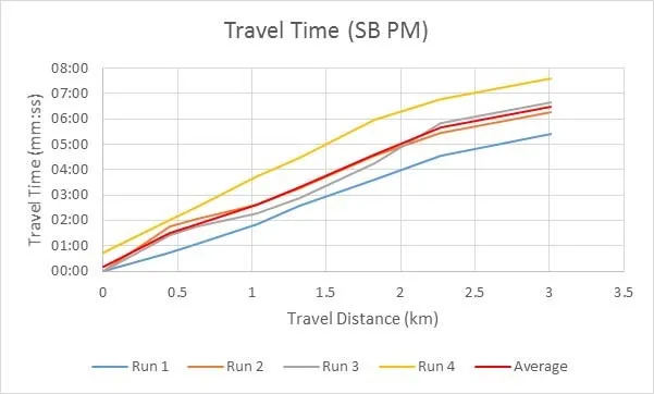
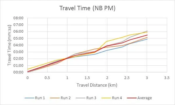
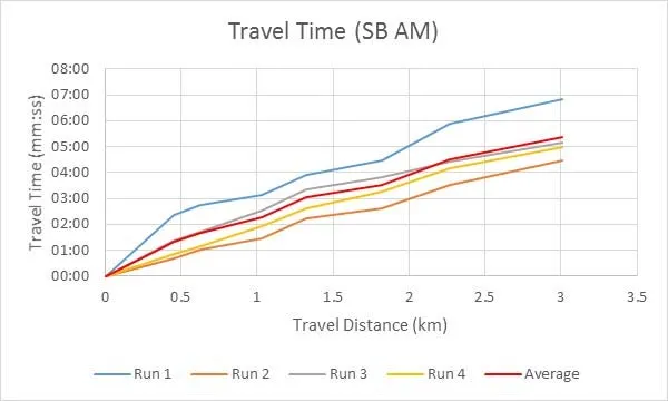
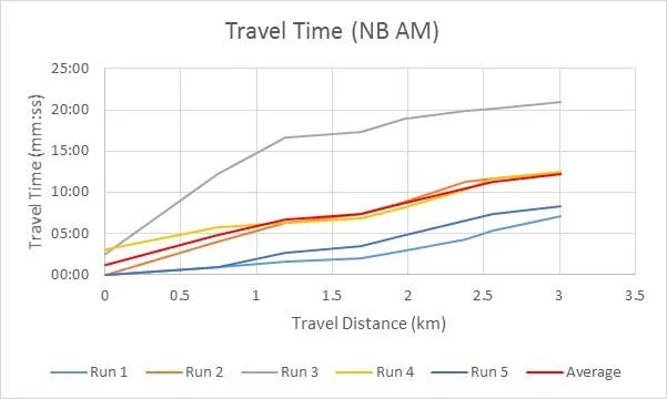
SLI conducted peak AM and PM period site drive through surveys on November 28th and 29th, 2017 to assess the existing travel times though the corridor and the lengths of queues at intersections. The travel time surveys were conducted between the Colwood Interchange and University Dr. The PM surveys were undertaken on Tuesday November 28th between about 3:30 PM and 6 PM. AM surveys were undertaken on Wednesday November 29th between about 6:30 AM and 9 AM. The recorded travel times are provided in Appendix A. The results recorded are presented on, Figures 3.1 through 3.4.
In the AM the southbound (SB) direction was found to have an average travel time of 5.4 minutes and the northbound (NB) direction an average travel time of 12.2 minutes. In the PM the SB direction was found to have an average travel time of 6.5 minutes and the NB direction a travel time of 5.5 minutes.
The longest travel times were observed in the AM peak period in the NB direction, which ranged from 7 minutes at the start and end of the AM period and reached 21 minutes during the “peak of the peak”. During the peak of the peak in the AM there were continuous queues from University Dr. to Wale Rd. During one run the NB queue started about 0.5 km before University Dr.
3.4 Corridor Travel Speeds and Congestion Zones
Based on SNC-Lavalin’s November 29, 2017 survey, the travel speed results for the NB direction in the AM peak are presented on Figure 3.5. The segments referred to on Figure 3.5 are the sections of the corridor between the signalized intersections along the corridor. The average speed shown in Figure 3.5 represents average of all 5 runs conducted during the AM peak period. The “peak-of-the-peak” shown in the graph represents the slowest run in the AM peak period.
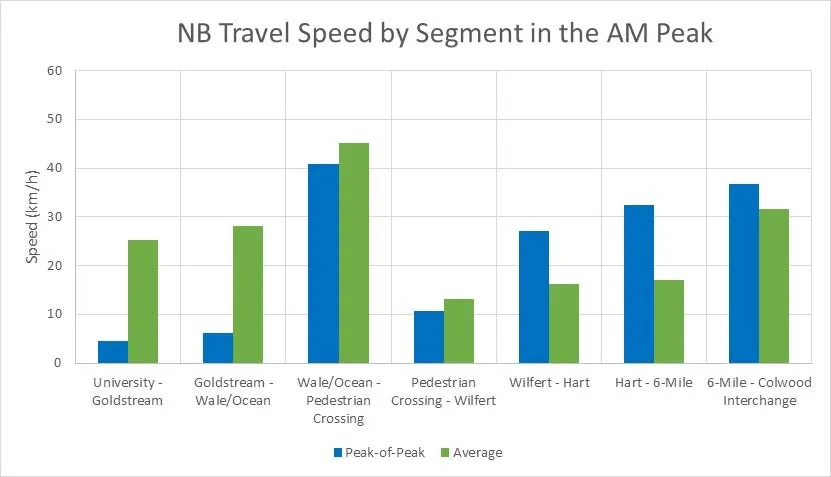
The “peak-of-the-peak” in the AM shows a much slower travel speed from University Dr. to Ocean Blvd as compared to the average for the AM peak period. The northern section of the corridor (Wilfert Rd. to the Colwood Interchange) shows a higher travel speed as a result of the upstream congestion reducing the number of vehicles getting through to this section. Even with higher travel speeds at the north end of the corridor, the overall travel time, as shown on Figure 4, is much longer for the “peak-of-the-peak” than the average travel time.
The northbound traffic between University Dr. and Ocean Blvd. was observed to have travel speeds less than 10 km/h during the AM “peak-of-the peak” (7:40 AM-8:10 AM). The northbound traffic between the Juan de Fuca Recreation Centre pedestrian activated signal and the 6-Mile Rd intersection, as observed had average travel speeds less the 20 km/h throughout the entire AM peak period (6:30 AM-8:30 AM).
Figure 3.6 presents the average speed from all 4 runs conducted during the PM peak period on November 28th, 2017. The “peak-of-the-peak” shown on the graph represents slowest run recorded in the PM Peak.
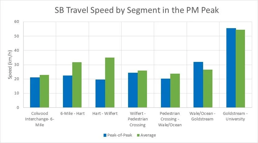
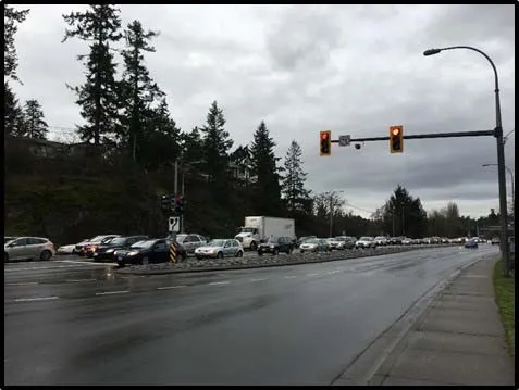
In contrast with the AM peak period, the travel speed in the “peak-of-the-peak” during the PM peak period is generally similar to the average travel time. This is because little congestion was observed during the site visit on November 28, 2017. However, significant southbound speed reduction has been observed southbound on Burnside Rd W from where it is joined by the westbound off ramp from Hwy 1, through the Colwood Interchange and along the Island Hwy as far as 6-Mile Rd. This periodic PM congestion has been confirmed from Google Earth travel times, input from BC Transit, observations from an SLI staff member, and from the CRD Transportation Model Estimates of traffic for PM-peak for 2018. Although not observed during the PM survey conducted on November 28, 2017, congestion is known to and is expected to occur in the peak PM period (3:50 AM-4:50 PM) along the Colwood Interchange to 6-mile section of the corridor with the CRD model forecasting increased congestion in this section.
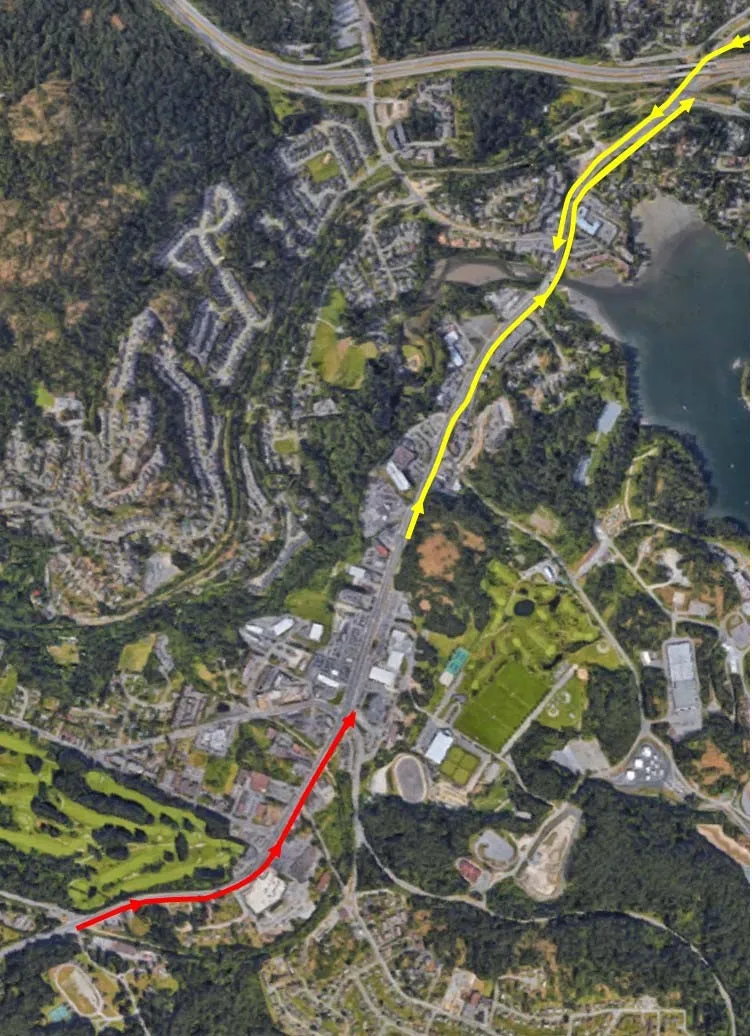
Based on the onsite measurements of peak period travel times collected by SLI, supplemented by PM Google travel time information, anecdotal information from BC Transit and SLI, as well as the CRD Regional Transportation Model results, the corridor segments experiencing congestion and slow travel speed are illustrated on Figure 3.7. The portion of the corridor shaded red indicates zones with travel speeds less than 10 km/hr. The yellow shaded portions of the corridor indicate zones with travel speeds less than 20 km/hr. These zones are recommended as the focus sections for the evaluation and implementation of remedial transit priority measures.
3.5 Bus Travel Times
Bus travel time data from the fall of 2016 was provided by BC Transit for bus routes 51 and 50. The bus travel data is measured form stop to stop and shown as an hourly average. Along the section of Island Hwy between 6-Mile Rd and Goldstream Ave the travel time data shows an average bus travel time in the AM peak of 5 minutes traveling SB, and 5.3 minutes traveling NB. The travel times also indicated slow spots between Wale Rd. and Goldstream Ave in the SB direction and between Goldstream Ave. and Wilfert Rd. in the NB direction. We note that the average travel time of 5.3 minutes now appears unrepresentative for the NB AM peak period, since the travel times from SNC-Lavalin’s November 29, 2017 survey by private automobile resulted in the following travel times between Goldstream Ave. and 6-Mile Rd.:
Run 1: 4:21; Run 2: 7:38; Run 3: 7:58: Run 4: 5:50; Run 5: 6:32;
Average of Runs 1-4: 6:26
Accounting for the 2 bus stops along this section of the corridor, at Ocean Blvd. and at Wilfert Rd., bus travel times would be expected to take longer for this run than the travel times recorded for general purpose traffic.
As presented on Figure 4, travel time data collected on November 29, 2017 for the AM peak showed a large variance in the NB travel time though the entire 3 km corridor, with the longest run taking 21 minutes and the shortest run taking 7 minutes. This large variability in travel time during the peak period has a significant impact on Transit’s schedule reliability making it hard to achieve on time arrivals at bus stops.
The paramount problem/challenge facing BC Transit and bus travelers at present is that during the weekday morning and afternoon peak congestion periods, buses can only move along the Island Hwy/Sooke Rd. corridor at the slow pace of general traffic offering no travel time advantage to bus passengers. In addition, the variability in travel times significantly impacts the ability to effectively schedule transit services along the corridor. Both these impacts tend to discourage transit use adversely impacting the ability to improve the mode share for Transit.
Based on the travel time data collected the zones highlighted on Figure 7 are recommended as the focus sections for the evaluation and implementation of remedial transit priority measures including Transit Signal Priority (TSP) and bus queue jump lanes at intersections and in congested zones of the corridor.
4.0 Transit Priority Options
4.1 Development of Candidate NB and SB Transit Priority Options
Initial development of transit priority options focused on providing bus queue jump lanes approaching the existing signalized intersections along the corridor while staying within the existing right-of-way and avoiding significant reconfiguration of the existing travel lanes. Where there were existing right turn deceleration lanes, consideration was given to using them as a bus queue jump lane, with right turn cut-off islands, if they existed, being modified to accommodate one or two stopped buses without impeding the flow of right turning traffic. Where there was opportunity within the existing right-of-way to provide a longer bus lane approaching or even continuing past the signal, this was pursued. In some cases, based on SNCL’s surveys of travel times and signal delays, it was felt the cost of providing bus queue jump lanes was not warranted, but transit signal priority measures could be implemented in the future if needed. Taking the above considerations into account SB and NB transit priority options were developed as described in tables 4.1 and 4.2. Conceptual designs of the optional measures developed are presented in Appendix B.
Table 4.1 - Candidate Transit Priority Measures – Southbound direction
| INTERSECTION | KM | TRANSIT SIGNAL PRIORITY (TSP)¹ | TRANSIT SIGNAL PROTECTED QUEUE JUMP PHASE² | QUEUE JUMP LANE LENGTH (≤100M) | BUS LANE LENGTH (≥100M) | COMMENTS |
|---|---|---|---|---|---|---|
| Colwood Interchange Signalized Intersection Option 1 | 0.0 | Possible | No (see comments) | 100 m | • Queue jump lane taper starts just past south end of Craigflower Creek Bridge • Benefit of TSP may be marginal relative to the reduction in delay provided by the queue jump lane • Protected queue jump needed if bus lane not continued past signal |
|
| Colwood Interchange Signalized Intersection Option 2 | 0.0 | Possible | No (see comments) | 280 m | • Bus lane starting just south of where Burnside Rd W SB joins WB to SB off-ramp from Hwy 1 WB • Craigflower Creek Bridge will need widening to accommodate 55 m long relocation of Galloping Goose Trail • Benefit of TSP may be marginal relative to the reduction in delay provided by the queue jump lane • Protected queue jump needed if bus lane not continued past signal |
|
| 6-Mile Rd Signalized Intersection | 0.5 | No | Yes | 510 m | • Bus lane a continuation of either the queue jump lane Option 1 above, or the bus lane Option 2 above • An existing bus stop is located within this bus lane |
|
| Hart Rd Signalized Intersection | 0.7 | No | No | • Minimal delay to Island Hwy traffic from intersection based on existing volumes |
| INTERSECTION | KM | TRANSIT SIGNAL PRIORITY (TSP)¹ | TRANSIT SIGNAL PROTECTED QUEUE JUMP PHASE² | QUEUE JUMP LANE LENGTH (≤100M) | BUS LANE LENGTH (≥100M) | COMMENTS |
|---|---|---|---|---|---|---|
| Wilfert Rd Signalized Intersection | 1.2 | No | No | • Minimal delay to Island Hwy traffic from intersection based on existing volumes • Existing near side bus stop to be relocated to a far side bus stop/bus bay |
||
| Juan de Fuca Pedestrian Activated Signals | 1.7 | No | No | • Minimal delay to Island Hwy traffic from intersection based on existing volumes • Access to Juan de Fuca Recreation Centre located at these signals • Pedestrian refuge located in Island Hwy median |
||
| Wale Rd/Ocean Blvd Signalized Intersection | 2.0 | Possible | No | 100 m | see comments | • 200 m approx. SB bus lane extends from south side of intersection to existing bus stop/bus bay • Benefit of TSP may be marginal relative to the reduction in delay provided by the queue jump lane |
| Goldstream Ave Signalized Intersection | 2.4 | Yes | No | • Existing far side bus stop has no bus bay • Insufficient space available in existing corridor X-section for a queue jump lane |
||
| University Dr/Aldeane Ave Signalized Intersection | 3.0 | Optional | No | • Existing far side bus stop has no bus bay • South of south limit (Jerome Rd) of current project |
Table 4.2 - Candidate Transit Priority Measures – Northbound direction
| INTERSECTION | KM | TRANSIT SIGNAL PRIORITY (TSP)¹ | TRANSIT SIGNAL PROTECTED QUEUE JUMP PHASE² | QUEUE JUMP LANE LENGTH (≤100M) | BUS LANE LENGTH (≥100M) | COMMENTS |
|---|---|---|---|---|---|---|
| University Dr/Aldeane Ave Signalized Intersection | 3.0 | Optional | No | • Transit Signal Priority may not be effective when NB traffic in AM backed up from Goldstream Ave and beyond • Existing far side bus stop has no bus bay • South of south limit (Jerome Rd) of current project |
||
| Goldstream Ave Signalized Intersection | 2.4 | No | Yes | 325 m | • An existing near side bus stop is located within this bus lane | |
| Ocean Blvd/Wale Rd Signalized Intersection | 2.0 | Possible | No | 100 m | See comments | • 120 m approx. NB bus lane extends from north side of intersection to existing bus stop/bus pullout • Benefit of TSP may be marginal relative to the reduction in delay provided by the queue jump lane |
| Juan de Fuca Pedestrian Activated Signals | 1.7 | No | No | • Minimal delay to Island Hwy traffic from intersection based on existing volumes • Access to Juan de Fuca Recreation Centre located at these signals • Pedestrian refuge located in Island Hwy median |
||
| Wilfert Rd Signalized Intersection | 1.2 | No | No | • Minimal delay to Island Hwy traffic from intersection based on existing volumes • Existing far side bus stop/bus bay |
||
| Hart Rd Signalized Intersection | 0.7 | No | No | • Minimal delay to Island Hwy traffic from intersection based on existing volumes |
| INTERSECTION | KM | TRANSIT SIGNAL PRIORITY (TSP)¹ | TRANSIT SIGNAL PROTECTED QUEUE JUMP PHASE² | QUEUE JUMP LANE LENGTH (≤100M) | BUS LANE LENGTH (≥100M) | COMMENTS |
|---|---|---|---|---|---|---|
| 6-Mile Rd Signalized Intersection | 0.5 | Yes | No | • Insufficient space available in existing corridor X-section for a queue jump lane | ||
| Colwood Interchange Signalized Intersection | 0.0 | No | Yes | 30 m (see comments) | 375 m | • NB traffic to EB (old) Island Hwy backs up into the existing right turn lane and beyond during the AM weekday peak period. This will delay NB buses heading to Hwy 1 EB, unless they can travel in NB thru lanes of Island Hwy before easing into an approx. 30 m queue jump at the signals • An existing bus stop is located within this bus lane |
Explanatory Notes
- Transit Signal Priority: Traffic Signals can detect the arrival of a bus via inductive loops or other detection methods, and attempt to extend green phases and/or truncate red phases to reduce the delay for the bus.
- Fully-Protected Transit Queue Jump Phase: Traffic Signals can insert a dedicated, fully protected transit phase, to allow a bus in the designated queue jump lane to proceed ahead of general traffic into a general purpose lane beyond the signal.
4.2 Analysis and Evaluation of Candidate Transit Priority Options
To analyze the candidate options, a microscopic simulation or “microsimulation” model of the corridor was developed using PTV-VISSIM (“VISSIM”). Microsimulation models the individual entities (car, bus, pedestrian). It is different from macroscopic simulation which looks at averaged variables like flow and density. VISSIM simulates the following types of traffic:
- Vehicles (cars, trucks, buses)
- Public Transit (buses, trams)
- Cycles (bicycles, motorcycles)
- Pedestrians
At the microscopic level, traffic flows are sensitive to detailed infrastructure changes. VISSIM models are built with detailed configurations of the road infrastructure.
VISSIM models were created for the existing infrastructure conditions and for the proposed infrastructure upgrades associated with the candidate priority measures.
VISSIM microscopic models were constructed for the existing infrastructure conditions and for the proposed infrastructure upgrades associated with the candidate priority measures. The AM and PM peak periods were analyzed using 2018 volumes developed from the CRD model. The volumes in the CRD model were adjusted to balance the flow between intersections and to reflect the observed traffic patterns provided in the June 2013 Victoria Transit Priority Corridor Plan. . The model was validated against the existing conditions and the travel time surveys collected. Once validated the model was used to simulate and analyze the impacts of the candidate transit priority measures.
Statistical performance indicators were used as criteria for evaluating the options and included:
- Level-of-Service [LOS],
- Delays,
- Queue lengths
Figure 4.1 – Field condition (left) and VISSIM model (right) AM Peak Period at Colwood-Hwy 1 Interchange
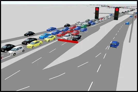
Projections of 2018 and 2038 AM and PM peak hour traffic along the Island Hwy/Sooke Rd corridor were provided by CRD, from the Preliminary CRD Transportation Model Evaluation. Since they provided through volumes only along the corridor and along important road connections such as 6-Mile Rd, Wale Rd, Ocean Blvd and Goldstream Ave, it was necessary for SNCL to estimate 2018 turning volumes at the signalized intersections. This was done by reviewing turning volumes in the June 2013 Victoria Transit Priority Corridor Plan, Options Evaluation Report, and factoring them to match the through volumes in the 2018 CRD model. SNCL’s assessment of the effectiveness of the transit priority options was based only on the 2018 traffic projections.
4.3 2018 Exiting Conditions Simulation Results
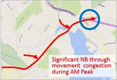
Detailed results of the VISSIM model for the existing conditions are provided in Appendix D. Figure 4.2 illustrates focus areas based on the existing conditions. Key conclusions from the microsimulation of the existing conditions along the corridor include:
AM Peak Period:
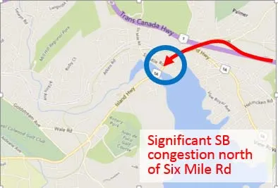
- The merging point at Highway 1 on-ramp (circled in blue) causes significant northbound congestion, this congestion backs up all the way to Aldeane Ave. Every signalized intersection operates at LOS D or worse as a result
- NB often takes multiple cycles to clear an intersection
- EB Left turns at Wale Rd and Six Miles Rd are also congested as a result of NB movement on Island Hwy
- NB’s run time is significant longer than SB’s during PM
PM Peak Period:
- There is significant SB congestion north of Six Mile Rd. Six Mile Rd does not appear to have sufficient green time throughput to accommodate all SB flows. As a result, this intersection acts as a bottleneck to SB traffic
- SB flow also diminishes and disperses into local major roads the further south they travel
- As a result of the above factors, congestion is reduced south of Six Mile Rd.
Figure 4.2 – Existing Conditions Simulation – Focus Areas
4.4 Transit Priority Measures Simulation Results
The VISSIM model was used to analyze the candidate transit priority infrastructure and signal upgrades. Infrastructure upgrades including the bus queue jump lanes and signal treatments including the addition of TSP and a fully protected transit queue jump phase were incorporated into the VISSIM model set up.
Detailed results of the VISSIM model incorporating the candidate transit priority are provided in Appendix D. Key conclusions from the microsimulation were categorized under travel time savings for transit vehicles and delay and LOS impacts to general traffic.
Bus Travel Time
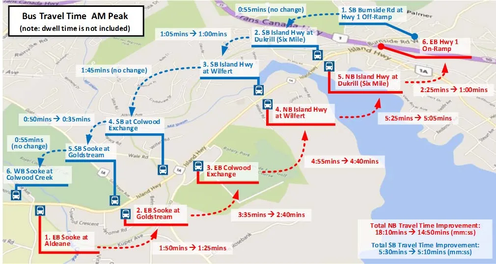
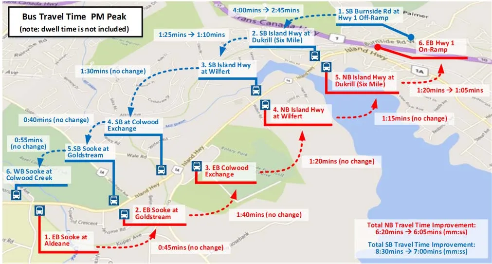
Total estimated transit travel time results from the VISSM model are summarized on Table 4.1 for the southbound and northbound directions, respectively. A graphical presentation of the results is provided on Figures 4.1 and 4.2. A detailed breakdown, by corridor segment, of the total estimated travel time savings is provided in Appendix C. Overall, the results indicate that:
- In the critical direction (i.e. NB during AM, and SB during PM), a savings in transit travel time of approximately 20% is anticipated when travelling through the study area with implementation of the transit priority improvements;
- In the non-critical direction, only minor transit travel time savings of approximately 5% are anticipated
Table 4.1 Transit travel time savings southbound direction AM and PM Peak Periods
| Transit travel Direction | AM Peak Period: Travel Time no Improvements (mm:ss) | AM Peak Period: Travel Time (with transit Priority Improvements | AM Peak Period: Transit travel time savings | PM Peak Period: Travel Time no Improvements (mm:ss) | PM Peak Period: Travel Time (with transit Priority Improvements | PM Peak Period: Transit travel time savings |
|---|---|---|---|---|---|---|
| Southbound | 5:30 | 5:10 | 00:20 | 8:30 | 5:55 | 2:35 |
| Northbound | 18:10 | 14:50 | 3:20 | 6:20 | 6:05 | 0:15 |
Impacts to General Traffic
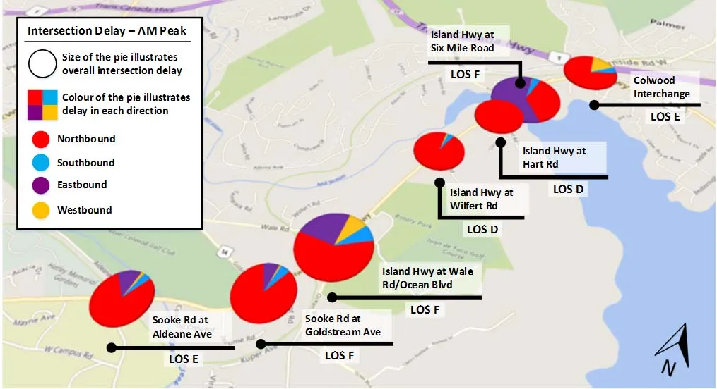
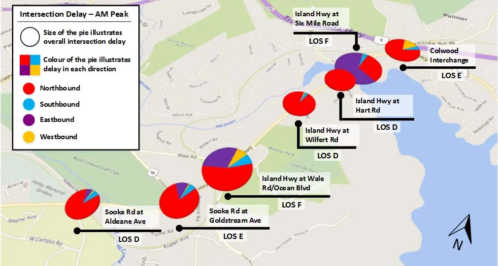
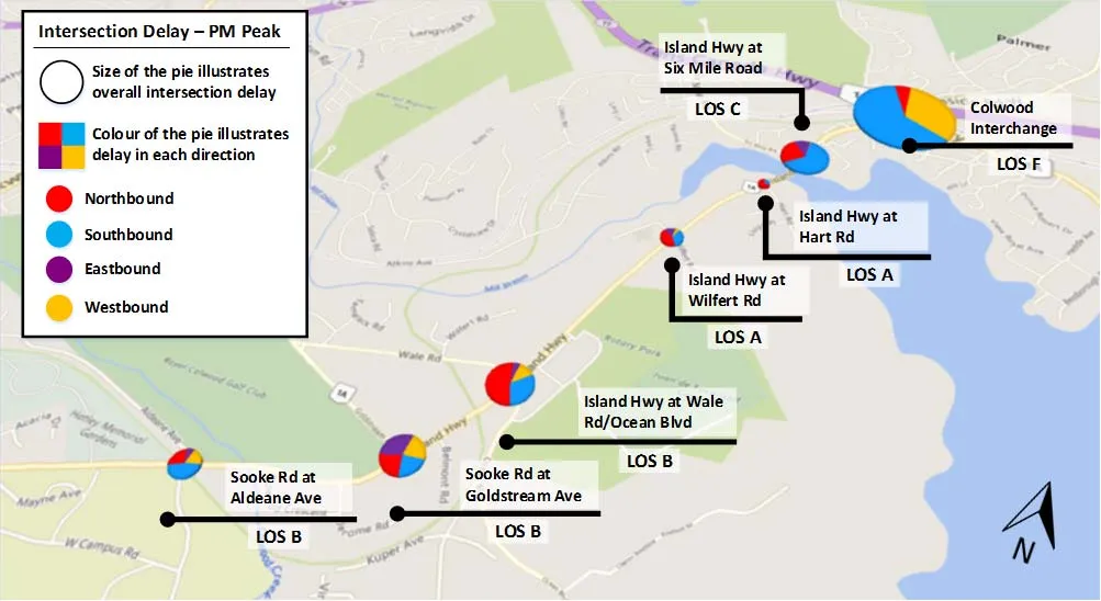
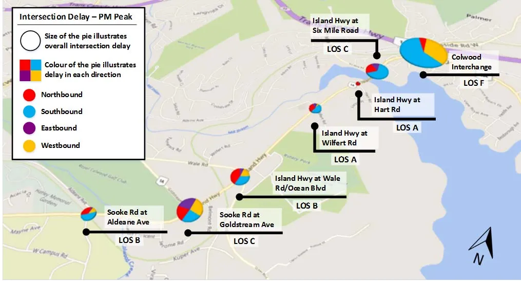
Results of the VISSIM modelling for general traffic impacts, as measured by LOS and delay, are summarized graphically on Figures 4.3 through 4.6 for the AM and PM peak periods, respectively. Overall the results indicate that:
- Transit priority measures will slightly improve NB and SB flows, but slightly increase the delay for EB and WB flows on cross streets
- Most intersections will experience similar LOS compared to existing conditions; some may experience slightly better LOS due to improved major movement flows
- Transit priority measures will also impact the performance at adjacent intersections, due to re-allocation of green times. However, the impact is projected to be minor.
5.0 Potential Construction Packages and Budget Estimates
5.1 Potential Construction Packages
The potential transit priority improvements were broken into construction packages providing the flexibility to implement the measures in a phased manner. Table 5.1 summarizes the potential construction packages. The packages are organized by direction. Southbound packages are identified with an S and northbound packages with an N. The sketches referred to on Table 5.1 are provided in Appendix B. Figures 5.1 and 5.2 present a high level view of the project corridor and the proposed transit priority improvements.
It is important to note that Packages S1 and S2 are sub-components of package S3. They provide the potential to implement portions of package S3 in a staged manner based on the physical attributes of the section of the corridor stretching from the TCH off ramp to the Colwood interchange signalized intersection.
Document Images
(3)