Appendix
BC Transit - Near Term Park-and-Ride Options Evaluation
January 15, 2019Pages 113–1186 sections
Detailed evaluation and summary table of potential near-term park-and-ride sites near the Langford Transit Exchange and surrounding corridors.
Locations: Langford Pkwy, Station Ave, Jacklin Rd, Goldstream Ave, Colwood interchangeRatings include Park & Ride Capacity and Connectivity to Bus RoutesStation Ave near Veterans Memorial Pkwy ranked 1st overall
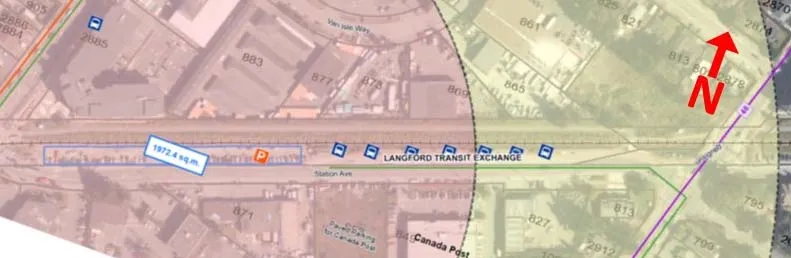
Station Ave. near Langford Transit Exchange
Park & Ride Capacity:
- The park-and-ride 1972 sq.m (56 spots) based on 35 sq.m per car needed, including access and egress, for a curbed gravel parking spot.
- (Red)
Connectivity to Bus Routes:
- The park and ride is next to the Langford Transit Exchange.
- (Green)
Walking Distance to Bus Stops:
- The Langford exchange is less than 200m from the park and ride.
- (Green)
Nature of Park & Ride Site:
- This land is within the E&N railway right of way and is administered by the Island Corridor Foundation.
- The area is already a fairly level public gravel parking lot, likely used as an unofficial park and ride for the Langford Transit Exchange.
- (Green)
Impact on Neighbourhood Land Uses:
- This site is an existing gravel parking lot likely used as an unofficial park and ride for the Langford exchange.
- This land is administered by the Island Corridor Foundation.
- The connection to the potential park-and-ride is currently from Station Ave which is a local non-residential road.
- (Green)
Regional Context:
- This park and ride location has access to the all routes at the Langford Transit Exchange.
- (Green)
Overall Rating:
- 5th
Page 113–118
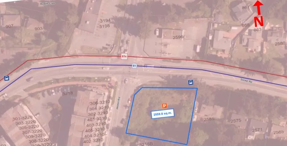
Jacklin Rd at Sooke Rd
Park & Ride Capacity:
- The park-and-ride 2560 sq.m (73 spots) based on 35 sq.m per car needed, including access and egress, for a curbed gravel parking spot.
- (Yellow)
Connectivity to Bus Routes:
- There are no Local Transit-High Demand bus routes passing this stop.
- There is one regional route passing this stop No. 61.
- (Green)
Walking Distance to Bus Stops:
- The bus stops are less than 200m from the park and ride.
- (Green)
Nature of Park & Ride Site:
- The area is an undeveloped vacant lot with some outcroppings of rook. The lot will need to be cleared and the parking lot will need to be constructed.
- (Red)
Impact on Neighbourhood Land Uses:
- This site is an undeveloped vacant lot within a low and high density residential area next to Hwy 14, Sooke Rd.
- The connection to the potential park-and-ride is currently from Jacklin Rd and Sooke Rd which are major roads.
- (Green)
Regional Context:
- This park and ride location has access to regional bus route No. 61
- (Green)
Overall Rating:
- 6th
Page 113–118
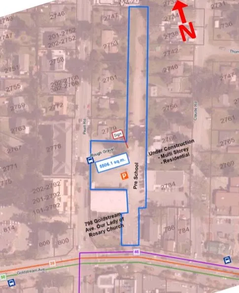
Goldstream Ave. at Peatt Rd
Park & Ride Capacity:
- The park-and-ride 5506 sq.m (157 spots) based on 35 sq.m per car needed, including access and egress, for a curbed gravel parking spot
- (Green)
Connectivity to Bus Routes:
- There are two Local Transit-High Demand bus routes passing this stop Nos. 39 & 46 (future)
- There is one regional route passing this stop No. 50
- (Green)
Walking Distance to Bus Stops:
- The bus stops are less than 200m from the park and ride.
- (Green)
Nature of Park & Ride Site:
- The area is a parking lot currently used for parking at Our Lady of the Rosary Church and the pre-school/daycare next door.
- This location is a mix of gravel parking and paved.
- (Green)
Impact on Neighbourhood Land Uses:
- This parking lot is currently used for parking at Our Lady of the Rosary Church and the pre-school daycare next door.
- The connections to the potential park-and-ride are already existing and in use.
- (Red)
Regional Context:
- This park and ride location has access to regional bus route No. 50
- (Green)
Overall Rating:
- 2nd
Page 113–118
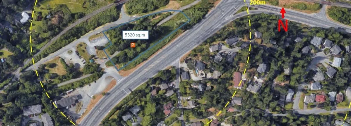
Colwood Exchange
Park & Ride Capacity:
- The park-and-ride 5320 sq.m (152 spots) based on 35 sq.m per car needed, including access and egress, for a curbed gravel parking spot
- (Green)
Connectivity to Bus Routes:
- There are two Local Transit-High Demand bus routes passing the existing stops, Nos. 39 & 46 (future)
- There are two regional routes passing these stops, Nos. 50 & 61.
- (Green)
Walking Distance to Bus Stops:
- The bus stops are 200 m from, and south of this potential park and ride site. However, crossing Island Highway to the existing NB stop may be inconvenient since the closest pedestrian crossing is located south of the park and ride at 6-Mile Rd. If another NB bus stop could be located at the Colwood Hwy 1 Interchange, bus passengers could cross the Island Hwy at the existing E&N Rail Trail signalized X-walk, about 200 m distant. Another option would be to provide a 2-stage pedestrian activated X-walk at Atkins Rd intersection, with a central raised median refuge, similar to the one at Juan de Fuca Rec Centre.
- (Yellow)
Nature of Park & Ride Site:
- This location is generally an undeveloped lot with some gravel parking for users of the Galloping Goose Regional Trail.
- (Yellow)
Impact on Neighbourhood Land Uses:
- This site is generally undeveloped land, owned we understand, by the Province, and reserved for the future Victoria Regional Rapid Transit system.
- The connection to the potential park-and-ride is currently from Atkins Rd/6-Mile Rd but could also be direct from the Island Hwy via an existing road.
- (Green)
Regional Context:
- This park and ride location has access to regional bus route Nos. 50 & 61
- (Green)
Overall Rating:
- 3rd
Page 113–118
NW ENR/Peatt
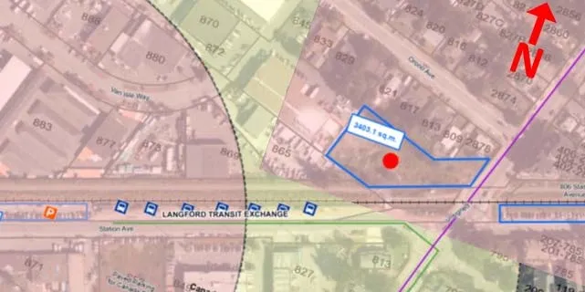
Park & Ride Capacity:
- The park-and-ride site is 3403 sq.m (97 spots) based on 35 sq.m per car needed, including access and egress, for a curbed gravel parking spot
- (Yellow)
Connectivity to Bus Routes:
- The park and ride is next to the Langford Exchange.
- (Green)
Walking Distance to Bus Stops:
- The Langford exchange is less than 200 m from the park and ride.
- (Green)
Nature of Park & Ride Site:
- This site is a fairly level non-wooded vacant lot. This lot will require minimal work to clear to prepare the site for building the parking lot.
- (Yellow)
Impact on Neighbourhood Land Uses:
- This site is an undeveloped vacant lot.
- The connection to the potential park-and-ride is currently from Peatt Road which is a major road.
- (Green)
Regional Context:
- This park and ride location has access to the all busroutes at the Langford Transit Exchange.
- (Green)
Overall Rating:
- 4th
Page 113–118
Near Term Park-and-Ride Summary Table
| Langford Pkwy | Station Ave. near Veterans Memorial Pkwy | Station Ave. near Langford Transit Exchange | Jacklin Rd at Sooke Rd | Goldstream Ave. at Peatt Rd | Colwood interchange | NW ENR/ Peatt | |
|---|---|---|---|---|---|---|---|
| Park & Ride Capacity | (Red) | (Green) | (Red) | (Yellow) | (Green) | (Green) | (Yellow) |
| Number of Park & Ride Spots | 53 Spots | 161 spots | 56 spots | 73 spots | 157 spots | 152 spots | 97 spots |
| Connectivity to Bus Routes | (Yellow) | (Green) | (Green) | (Green) | (Green) | (Green) | (Green) |
| Walking Distance to Bus Stops | (Green) | (Green) | (Green) | (Green) | (Green) | (Yellow) | (Green) |
| Nature of Park & Ride Site | (Green) | (Green) | (Green) | (Red) | (Green) | (Yellow) | (Yellow) |
| Impact on Neighbourhood Land Uses | (Red) | (Green) | (Green) | (Green) | (Red) | (Green) | (Green) |
| Regional Context | (Yellow) | (Green) | (Green) | (Green) | (Green) | (Green) | (Green) |
| Overall Rating | 7th | 1st | 5th | 6th | 2nd | 3rd | 4th |
Page 113–118
Extracted from: 2019 01 15 Council Agenda - Agenda - Pdf