BC Transit - Potential Long Term Park-and-Ride Options Evaluation
Evaluation of future long-term park-and-ride facilities and summary table comparing capacity, connectivity, and impact.
Potential Long Term Park-and-Ride Options
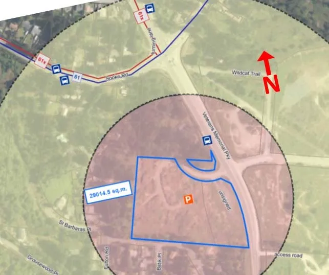
Veteran’s Memorial Parkway and Sooke Road
Park & Ride Capacity:
- The park-and-ride site is 29014 sq.m (829 spots) based on 35 sq.m per car needed, including access and egress, for a curbed gravel parking spot.
-
Connectivity to Bus Routes:
- There are no current Local Transit-High Demand bus routes.
- There is one regional route passing this stop No. 61.
- This site is on the transit future plan.
-
Walking Distance to Bus Stops:
- The bus stops are between 200 m and 400 m from the potential Park & Ride lot.
-
Nature of Park & Ride Site:
- This location is an undeveloped lot that is wooded with rocky outcroppings. The lot will need to be cleared and the parking lot will need to be constructed.
-
Impact on Neighbourhood Land Uses:
- This location is an undeveloped lot.
- The connection to the potential park-and-ride is currently from Veterans Memorial Parkway which is a Colwood arterial road.
-
Regional Context:
- This park and ride location is on the planned frequent transit network corridor, and has access to regional bus route No. 61.
-
Overall Rating:
- 3rd
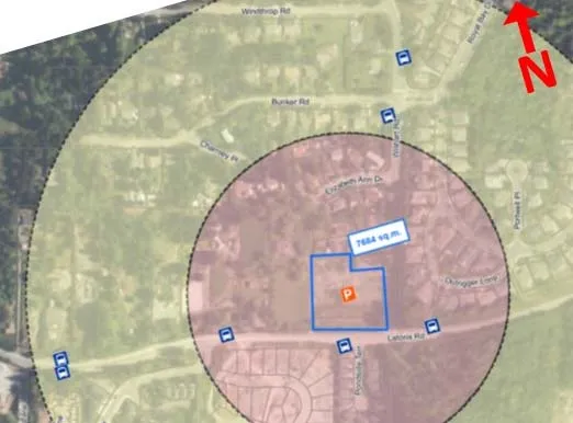
Latoria Road and Wishart Road
Park & Ride Capacity:
- The park-and-ride site is 7684 sq.m (220 spots) based on 35 sq.m per car needed, including access and egress, for a curbed gravel parking spot.
-
Connectivity to Bus Routes:
- There are no current Local Transit-High Demand bus routes passing this stop.
- There are no regional routes passing this stop.
- This site is on the transit future plan.
-
Walking Distance to Bus Stops:
- The bus stops are less than 200 m from the park and ride.
-
Nature of Park & Ride Site:
- The area is an already partially developed site with large piles of stones and built foundations that will need to be deconstructed and cleared.
-
Impact on Neighbourhood Land Uses:
- The area is already partially developed site with rock piles and partially built buildings. The area would look nicer and be safer if this site was developed. Latoria Rd is a Colwood arterial route.
-
Regional Context:
- The park-and-ride is location is on the planned frequent transit network corridor.
-
Overall Rating:
- 5th
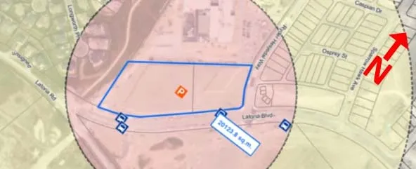
Latoria Road and Ryder Hesjedal Way
Park & Ride Capacity:
- The park-and-ride site is 20124 sq.m (575 spots) based on 35 sq.m per car needed, including access and egress, for a curbed gravel parking spot.
-
Connectivity to Bus Routes:
- There are no current Local Transit-High Demand bus routes passing this stop.
- There are no regional routes passing this stop.
- This site is on the transit future plan.
-
Walking Distance to Bus Stops:
- The bus stops are less 200 m from the park and ride.
-
Nature of Park & Ride Site:
- This site is a fairly level non-wooded vacant lot. This lot will require minimal work to clear to prepare the site for building the parking lot.
-
Impact on Neighbourhood Land Uses:
- This site is a vacant lot.
- The connection to the potential park-and-ride is currently from Latoria Boulevard which is a Colwood arterial road.
- The site is next to Royal Bay Secondary School which is busy during morning student drop-off, additionally adding extra traffic close to a school may cause traffic safety concerns.
-
Regional Context:
- The park-and-ride location is on is on the planned frequent transit network corridor.
-
Overall Rating:
- 4th
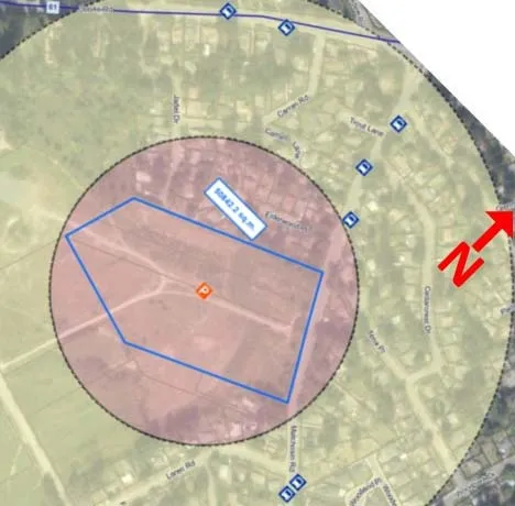
Metchosin Road and Laren Road
Park & Ride Capacity:
- The park-and-ride site is 51035 sq.m (1,458 spots) based on 35 sq.m per car needed, including access and egress, for a curbed gravel parking spot.
-
Connectivity to Bus Routes:
- There are no current Local Transit-High Demand bus routes.
- There is one regional route passing this stop No. 61.
- This site is on the transit future plan.
-
Walking Distance to Bus Stops:
- The bus stops are between 200 m and 400 m from the potential Park & Ride lot.
-
Nature of Park & Ride Site:
- This site is a fairly level non-wooded vacant lot. This lot will require minimal work to clear to prepare the site for building the parking lot.
-
Impact on Neighbourhood Land Uses:
- This site is vacant lot.
- The connection to the potential park-and-ride is currently from Metchosin Road which is a Colwood arterial route. There is also a possible future connection to Veterans Memorial Parkway.
-
Regional Context:
- This park and ride location is on the planned frequent transit network corridor, and has access to regional bus route No. 61.
-
Overall Rating:
- 2nd
Luxton Fairgrounds
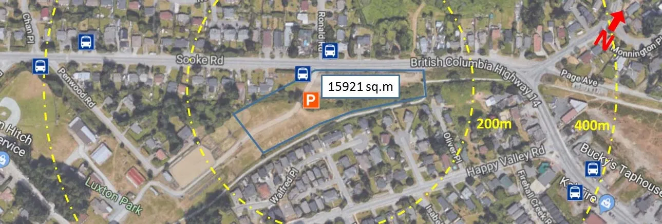
Park & Ride Capacity:
- The park-and-ride site is 15921 sq.m (454 spots) based on 35 sq.m per car needed, including access and egress, for a curbed gravel parking spot.
-
Connectivity to Bus Routes:
- There are no current Local Transit-High Demand bus routes.
- There is one regional route passing this stop, No. 61.
-
Walking Distance to Bus Stops:
- The bus stops are within 200 m of the potential Park & Ride lot.
-
Nature of Park & Ride Site:
- This site is a fairly level non-wooded vacant lot. This lot will require minimal work to clear to prepare the site for building the parking lot.
-
Impact on Neighbourhood Land Uses:
- This site is a vacant lot.
- The connection to the potential park-and-ride is currently from Hwy 14 Sooke Road which is a major road.
-
Regional Context:
- This park and ride location is on the planned frequent transit network corridor, and has access to regional bus route No. 61. BCMoTI has a confidential interest in this site.
-
Overall Rating:
- 1st
Long Term Park-and-Ride Facility Summary Table
| Veteran’s Memorial Parkway and Sooke Road | Latoria Road and Wishart Road | Latoria Road and Ryder Hesjedal Way | Metchosin Road and Laren Road | Luxton Fairgrounds | |
|---|---|---|---|---|---|
| Park & Ride Capacity | | | | | |
| Number of Park & Ride Spots | 829 spots | 220 spots | 575 spots | 1,458 spots | 545 spots |
| Connectivity to Bus Routes | | | | | |
| Walking Distance to Bus Stops | | | | | |
| Nature of Park & Ride Site | | | | | |
| Impact on Neighbourhood Land Uses | | | | | |
| Regional Context | | | | | |
| Overall Rating | 3rd | 5th | 4th | 2nd | 1st |
Prepared by: CK May 8, 2018 Reviewed by: TS May 8, 2018 SNC-Lavalin Project # 652113