Council Report: DEVELOPMENT PERMIT APPLICATION NO. 2021/01 – 1950 WEST PARK LANE - PHASE 3
A staff report recommending approval of a development permit for Phase 3 of the 'West Park at Thetis' development, including 15 residential units and a grade variance.
TO: Mayor and Council FROM: J. Chow, Senior Planner DATE: April 15, 2021 MEETING: April 20, 2021 FILE NO.: 3060-20-2021/01
DEVELOPMENT PERMIT APPLICATION NO. 2021/01 – 1950 WEST PARK LANE - PHASE 3
RECOMMENDATION:
THAT Development Permit No. 2021/01 be approved as per the April 15, 2021 report from the Senior Planner titled “Development Permit Application No. 2021/01 – 1950 West Park Lane - Phase 3.”
AND THAT Development Permit No. 2021/01 include approval of a variance to the definition of grade from “the weighted average of the existing grade or the finished grade, whichever is lower” to “the average finished grade as designated in the November 20, 2020 Plans prepared by Java Designs.”
AND FURTHER THAT Development Permit No. 2021/01 include the following conditions:
a. Environmental impacts and mitigation measures including steep slope and interface fire hazard management be implemented in accordance with Development Permit No. 2019/02. b. Landscape planting and irrigation is to be installed in accordance with current BCSLA/BCNTA Standards. c. A security deposit for hard and soft landscaping is required prior to building permit issuance. d. The security deposit of $50,000 provided in Development Permit No 2019/02 to address any unsafe conditions or damage to the natural environment apply to works authorized in this development permit. e. This development permit does not authorize any retaining walls over 1.2m in height.
CHIEF ADMINISTRATIVE OFFICER’S COMMENTS: I concur with the recommendation.
DIRECTOR OF DEVELOPMENT SERVICES’ COMMENTS: I concur with the recommendation.
DIRECTOR OF ENGINEERING’S COMMENTS: I concur with the recommendation.
PURPOSE:
To consider approval of a development permit to construct 15 residential units comprising Phase 3 of the “West Park at Thetis” comprehensive development. A variance to the definition of ‘grade’ is requested.
BACKGROUND:
The 4.26 ha parcel is north of Trans Canada Highway and backs on to Thetis Lake Regional Park (Attachment 1). The west half of the parcel is primarily hilly, forested terrain with a rocky hilltop. Thetis Lake Campground operated for decades on the east half of the property until 2018. The parcel is part of a six-phase comprehensive development. The CD-23: Comprehensive Development (Thetis Lake) zone permits a total of 350 residential units on this parcel and the adjacent property 1910/1920 West Park Lane. Access from West Park Lane is by easement over 1910/1920 West Park Lane.
Previously issued development permits of relevance to this phase include:
- Development Permit 2019/02 permitted subdivision to create this parcel and set out requirements for:
- identification of environmentally sensitive areas to be protected
- a security deposit for any unsafe conditions or damage to the natural environment
- interface fire hazard management
- Development Permit 2020/08 authorized site grading and clearing of this phase and future phases 4-6. It also included requirements for:
- geotechnical oversight
- covenants for safety inspection and maintenance of cut slopes and retaining walls
- considering of safety, scale, and timing of blasting in regard to the earthen dam at Thetis Lake Regional Park.
The application was introduced at the March 9, 2021 Committee of the Whole meeting.
PROPOSAL:
The proposal is to construct Phase 3 of a comprehensive development (see Figure 1). This phase is comprised of 15 residential units in three triplexes and three duplexes at the north end portion of the parcel. One variance is requested as part of the proposal.
The current development concept for future Phases 4-6 includes 13 townhouse units, two apartment buildings and two private green space areas.
In support of the application the following is provided as attachments to this report:
- Location plan
- Civil plans - Associated Engineering, November 12, 2020 (5 pages)
- Phase 3 Site Plan, - Java Design, November 20, 2020
- Block L Plans - Java Design, November 20, 2020 (4 pages)
- Block M Plans - Java Design, November 20, 2020 (4 pages)
- Block N Plans - Java Design, November 20, 2020 (5 pages)
- Block O Plans - Java Design, November 20, 2020 (5 pages)
- Block P Plans - Java Design, November 20, 2020 (5 pages)
- Block Q Plans - Java Design, November 20, 2020 (4 pages)
- Exterior Materials and lighting (5 pages)
- Planting Plan, KMZ Landscapes, November 19, 2020
- Landscape Masterplan, KMZ Landscapes, November 19, 2020
- Renderings – Blocks L & Q (2 pages)
- Grading Plan (updated) - Associated Engineering, March 18, 2021 *new*
- Additional Site Sections - Associated Engineering, March 23, 2021
- Storm Water Management Plan - Associated Engineering, September 20, 2019 (22 pages)
- Modifications to the Stormwater Master Plan & Interim SWMP/ESC Conditions Plan - Associated Engineering, November 12, 2020 (21 pages) *new*
- Drainage Catchment Areas and Surface Type – undated (2 pages) *new*
- Erosion and Sediment Control Plan - Associated Engineering, November 12, 2020 (2 pages) *new*
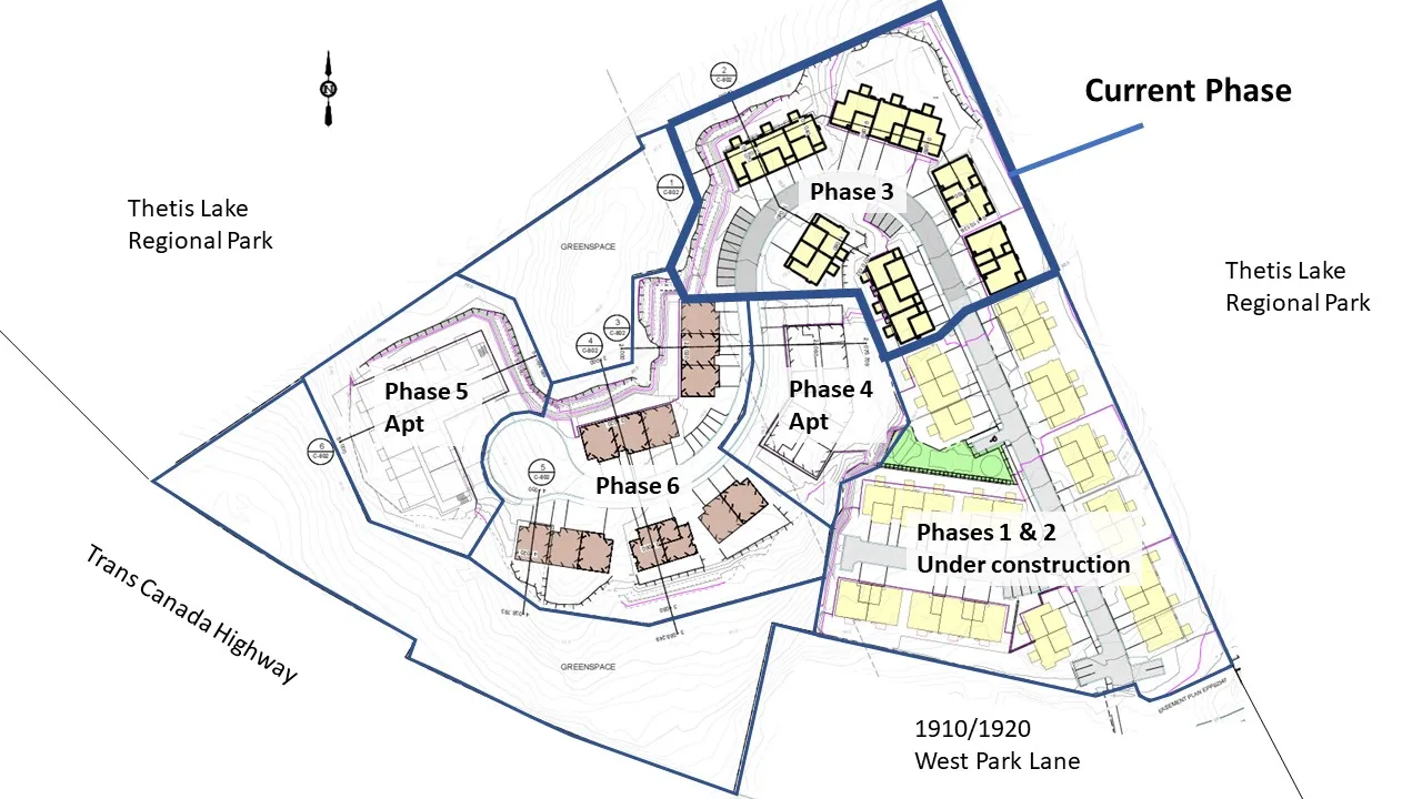
Figure 1. Development concept (subject to revision)
As shown in Figure 2, Blocks L, M, and N are on the low side of the central driveway, so buildings are one storey at the front with walkout basements at the rear. Block O and P are two storeys at the front and built into the slope, meaning there would be window wells for basement level bedrooms; however, there will be walkable grates over top for safety. Block Q is two storeys and on a flat site. More detailed building plans can be found in Attachments 4-9.
The landscaping (Attachments 11-12) will include chain link fencing as a barrier to Thetis Lake Regional Park. There will be no direct access from the site to the park. A planting buffer will provide additional screening along the park boundary.
Parking exceeds Zoning Bylaw requirements due to the provision of parking intended for visitors. This is supported because there is no on-street parking on this side of the Trans-Canada Highway.
To follow up the March 9, 2021 Committee of the Whole discussion:
- Building N is sited to maintain distance from the Thetis Lake Regional Park perimeter trail
- A pad mounted transformer location is provided near Block Q.
- No rooftop mechanical equipment is proposed in this phase.
- Units will have individual solid waste and recycling bins.
- The extent of grade changes precludes the construction of stairs to the green space near Block O. A more suitable access from Phase 5 can be explored at the time of that phase.
- All surface parking spaces are at least 5.5m as required by the Zoning Bylaw.
- While headlights of cars exiting the development will likely shine onto 1910 West Park Lane, trees adjacent to the building will provide some screening. Trees installed in front the building facing the driveway are species such as Spring Flurry Serviceberry that can grow to be 8.5m tall with a spread of 6m.
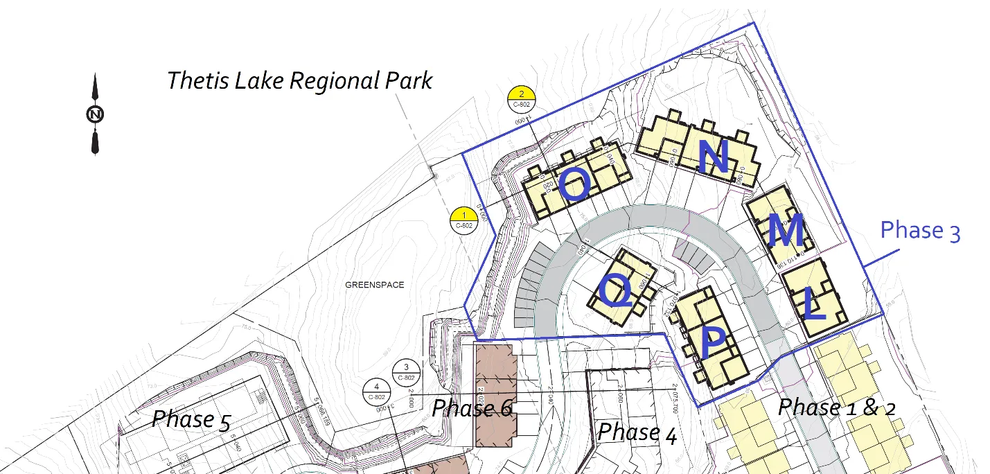
Figure 2. Building block plan and cross section locations
Retaining Walls
No retaining walls over 1.2m are indicated on the grading plans (Attachment 14). The retaining walls in this phase are intended to be made of stacked boulders recovered from site blasting, but they would not be visible from public roads. 1.5m wide benches are proposed along cut slopes near Building O so that cut slopes do not exceed 6.0m as shown in Figures 2 and 3.
While the applicant’s experience at the Thetis Vale development was that tall retaining walls to stabilize cut slopes were not needed, it will not be known until the blasting and grading is conducted if cut slopes on this site will require additional retaining walls. It should be noted that any retaining walls over 1.2m will require a development permit. Walls over 1.5m also require a building permit with sealed copies of the design plan and field review reports prepared by a registered professional.
Approved Development Permit 2020/08 already includes provisions for geotechnical overview of this phase and requiring a covenant for: a. Certification that the site is safe for the intended use b. Registration of a schedule for regular maintenance and inspection of cut faces and any walls over 1.5m
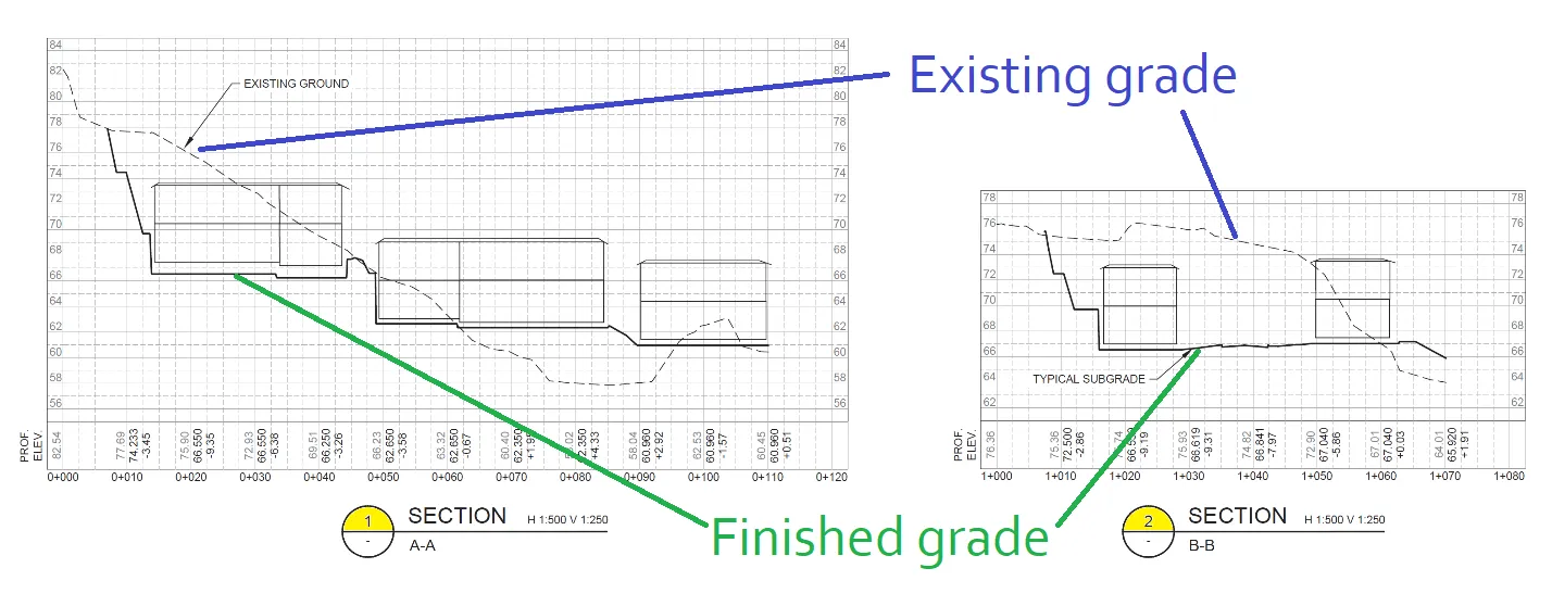
Figure 3. Partial site cross sections (Building O at far left)
Additional site sections can be found in Attachment 15.
DISCUSSION:
Key issues include the following:
- How does the proposal address the relevant development permit guidelines?
- How does the proposal comply with zoning requirements?
- How does the on-site servicing comply with overall requirements for the comprehensive development?
1. Development Permit Area Guidelines
Development is subject to the guidelines of two development permit areas: Mixed Residential and Sensitive Terrestrial Ecosystems.
Mixed Residential Development Permit Area (Form and Character)
The proposal generally complies with the Mixed Residential Development Permit Area guidelines as detailed in Attachment 20.
a. The form and massing of buildings will be similar to Phases 1 and 2. The development will have a contemporary West Coast treatment through the arrangement of natural toned cementitious materials, mullioned window treatments, extensively glazed entry doors and windowed garage doors as shown in Figure 4. b. Cladding includes horizontal plank and board & batten to provide variety and texture. In Phase 3, stone type cladding elements are introduced on Blocks L, N, O and P, which provides a substantial and higher quality finish (see Attachment 13). c. The blocks are arranged to follow the central driveway, which has been designed to minimize steep gradients as it traverses the sloping topography. d. Lighting will be dark skies friendly. Street lighting will be energy efficient LED.
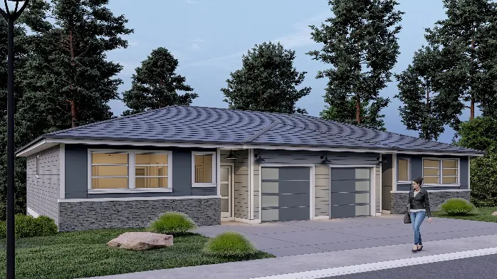
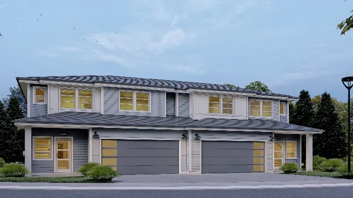
Figure 4. Block L rendering Block Q rendering
Sensitive Terrestrial Ecosystems Development Permit Area (Environmental and Hazard)
Approved Development Permit DP2019/02 set out environmental impact and mitigation measures including steep slope and interface fire hazard management for the comprehensive development in and will carry forward as requirements for this phase. Approved Development Permit 2020/08 allowed preclearing, blasting, and grading of this Phase 3 site with measures to:
- Protect retained trees on the periphery (and in the park)
- Address geotechnical / steep slope hazard management
- Control sediment and erosion
Interface fire hazard management requirements for the overall development were set out in Development Permit 2019/02 and apply to this phase. These include:
- Keeping 10m low fire fuel areas between buildings and the forest edge
- Use of fire-resistant roofing and cladding materials
- Enclosed metal soffits
- Buildings are to have fire sprinkler systems
At the detailed landscaping design stage, staff will work with the applicant to ensure adequate fire-resistant vegetative buffering for buildings facing Thetis Lake Regional Park. Development conditions should include the following: i. Planting is to be installed and irrigated in accordance with current BCSLA/BCNTA Standards ii. A cost estimate and security deposit for hard and soft landscaping is required prior to building permit issuance.
2. Zoning
The proposal complies with the land use and density requirements CD-23: Comprehensive Development (Thetis Lake) zone as shown in Attachment 21 and summarized in Tables 1-3.
Table 1. General Zoning
| Section | Description – CD-23 zone | Required | Proposed |
|---|---|---|---|
| 12.23.3. | Lot Size, minimum | 4000m² | 42,580 m² |
| 12.23.3. | Total number of residential units on all lands zoned CD-23 | Max 350 | Existing: 178 + Proposed Ph. 3: 15 Total: 193 |
| 12.23.3. | Total Floor Space Ratio on all lands zoned CD-23 | 0.78:1 | Existing: 10,200m² + Proposed: 2398m² Floor space: 12,598m² |
| Total CD-23 land area: 51,930m² | Total CD-23 FSR: 0.25:1 | ||
| 12.23.3. | Floor Space Ratio on 1950 West Park Lane for Residential, Townhouse or Residential, Duplex use Lot area: 42,580m² | 0.5:1 | Existing: 4827m² + Proposed: 2398m² Floor space: 7225m² |
| Total lot FSR 0.17:1 | |||
| 12.23.3. | Lot Coverage, maximum | 50% (21297.6m²) | 17.4% (7408.92 m²) |
Table 2. Setbacks
| CD-23 zone | Front Lot Line setback (West Park Lane) | Rear Lot Line setback | Side Lot Line setback (Thetis Lk Park) | Setback to Thetis Lake Park |
|---|---|---|---|---|
| Required | Min. 6.0m | min. 6.0m | Min. 4.5m | Min. 10.0m |
| Block L | >60.0m | >60.0m | 10.0m | 10.0m |
| Block M | >60.0m | >40.0m | 10.2m | 10.2m |
| Block N | >60.0m | 12.9m | 13.9m | 13.9m |
| Block O | >60.0m | 14.8m | >30.0m | >30.0m |
| Block P | >60.0m | >60.0m | >40.0m | >40.0m |
| Block Q | >60.0m | >40.0m | >50.0m | >50.0m |
Table 3. Other
| Section | Description | Required | Proposed | Variance |
|---|---|---|---|---|
| 2.2 | Definition of Grade | Weighted average of the existing grade or the finished grade, whichever is lower | Avg finished grade as designated on plans | Avg finished grade as designated on plans |
| 5.2.2 (e) | Maximum gradient and cross slope | 6 % residential zones | <6% |
Requested Variance
Using average finished grade rather than average grade to measure building heights The proposed variance to measure each building’s height from “the average finished grade as designated in the November 20, 2020 Plans prepared by Java Designs” (Attachments 4-9) rather than the lower of the average finished and natural grades can be supported for the following reasons: i. The site topography is steep, and extensive regrading has been required to accommodate the central driveway (see Figures 2 and 3). The variance is necessary to create building sites that can access the driveway. ii. The finished grades have been established through careful engineering work. This development permit would commit development to those finished grades. iii. The variance allows for efficient administration of the development and the Town’s experience at Thetis Vale for this type of situation has been informative.
Additional Notes
Zoning Bylaw No. 900, 2014, Amendment Bylaw No. 1062, 2020 was adopted February 2 to require that every required residential parking space (except secondary suites and home occupation parking) must be an Energized Electric Vehicle Space. Also, every required Class 1 bicycle parking space must be an Energized Electric Bicycle Space.
3. Servicing
When this parcel was subdivided in 2019, water, sanitary sewer, and storm drain connections were installed at West Park Lane to accommodate the overall development. The sewer and drain connection provided at the time of subdivision is adequately sized to accommodate this phase and future phases (to be confirmed again at that time). The Storm Water Management Plan (Attachment 16) has been updated (Attachments 17 and 18) to include an additional stormceptor within this phase to treat storm water from both this phase and future Phases 4-6.
Site and servicing access is by easement over the adjoining parcel at 1910/1920 West Park Lane. A central driveway connects the phases. An erosion and sediment control plan (Attachment 19) has been included for this phase.
RECOMMENDATION:
THAT Development Permit No. 2021/01 be approved as per the April 15, 2021 report from the Senior Planner titled “Development Permit Application No. 2021/01 – 1950 West Park Lane - Phase 3.”
AND THAT Development Permit No. 2021/01 include approval of a variance to the definition of grade from “the weighted average of the existing grade or the finished grade, whichever is lower” to “the average finished grade as designated in the November 20, 2020 Plans prepared by Java Designs”.
AND FURTHER THAT Development Permit No. 2021/01 include the following conditions:
a. Environmental impacts and mitigation measures including steep slope and interface fire hazard management be implemented in accordance with Development Permit No. 2019/02. b. Landscape planting and irrigation is to be installed in accordance with current BCSLA/BCNTA Standards. c. A security deposit for hard and soft landscaping is required prior to building permit issuance. d. The security deposit of $50,000 provided in Development Permit No 2019/02 to address any unsafe conditions or damage to the natural environment apply to works authorized in this development permit. e. This development permit does not authorize any retaining walls over 1.2m in height.
SUBMITTED BY: Jeff Chow, MCIP, RPP Senior Planner
REVIEWED BY: Lindsay Chase, MCIP, RPP Director of Development Services
ATTACHMENTS
- Location plan
- Civil plans - Associated Engineering, November 12, 2020 (5 pages)
- Phase 3 Site Plan, - Java Design, November 20, 2020
- Block L Plans - Java Design, November 20, 2020 (4 pages)
- Block M Plans - Java Design, November 20, 2020 (4 pages)
- Block N Plans - Java Design, November 20, 2020 (5 pages)
- Block O Plans - Java Design, November 20, 2020 (5 pages)
- Block P Plans - Java Design, November 20, 2020 (5 pages)
- Block Q Plans - Java Design, November 20, 2020 (4 pages)
- Exterior Materials and lighting (5 pages)
- Planting Plan, KMZ Landscapes, November 19, 2020
- Landscape Masterplan, KMZ Landscapes, November 19, 2020
- Renderings – Blocks L & Q (2 pages)
- Grading Plan (updated) - Associated Engineering, March 18, 2021 *new*
- Additional Site Sections - Associated Engineering, March 23, 2021
- Storm Water Management Plan - Associated Engineering, September 20, 2019 (22 pages)
- Modifications to the Stormwater Master Plan & Interim SWMP/ESC Conditions Plan - Associated Engineering, November 12, 2020 (21 pages) *new*
- Drainage Catchment Areas and Surface Type – undated (2 pages) *new*
- Erosion and Sediment Control Plan - Associated Engineering, November 12, 2020 (2 pages) *new*
- Development Permit Guideline review (7 pages)
- Zoning Review (3 pages)
Document Images
(3)