Presentation: DEVELOPMENT PERMIT 2021/01 - 1950 West Park Lane
Slideshow summarizing the Phase 3 townhouse development permit application.
DEVELOPMENT PERMIT 2021/01
1950 West Park Lane
Form & Character and Environmental Development Permit for Phase 3 townhouses at West Park at Thetis
- One variance is requested
BACKGROUND:
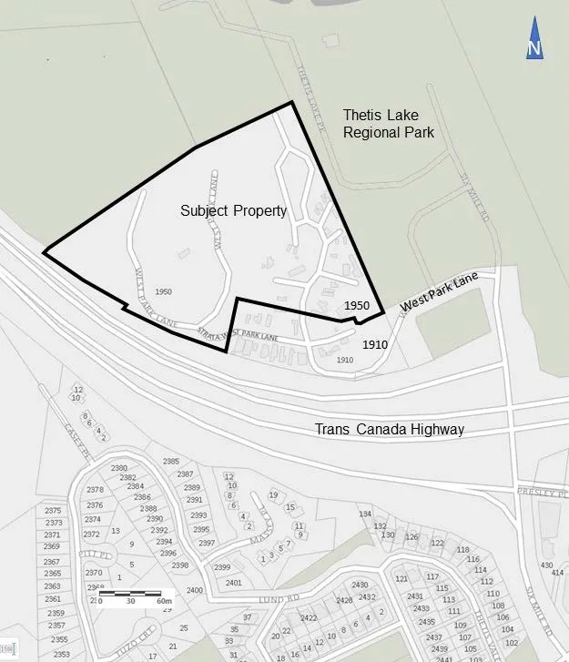
- 4.26 ha parcel
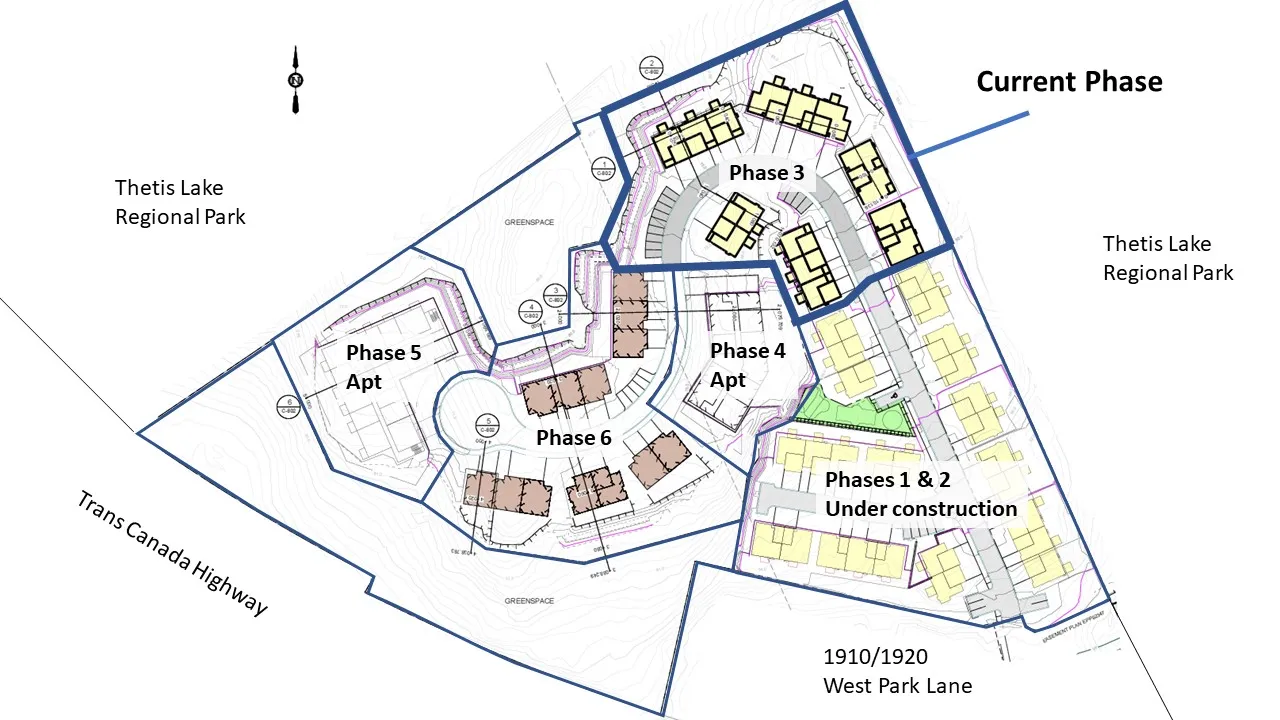
- Part of a six-phase comprehensive development.
- The CD-23: Comprehensive Development (Thetis Lake) zone permits a total of 350 residential units on this parcel and the adjacent property 1910/1920 West Park Lane.
- Access from West Park Lane is by easement
PROPOSAL:
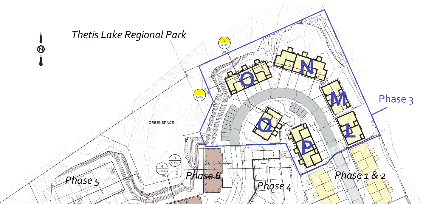
- 15 residential units in three triplexes and three duplexes
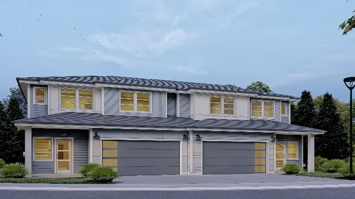
Block L and Block Q Renderings
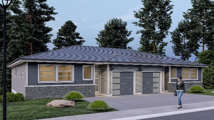
Color Palette Groupings:
- Blocks O, P
- Block N
- Blocks M, Q
- Block L
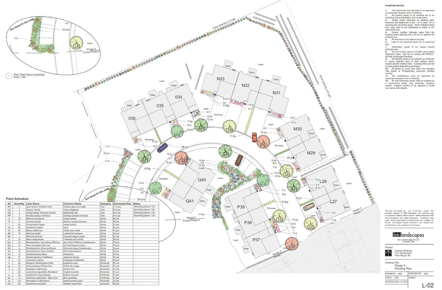
To follow up the March 9, 2021 Committee of the Whole discussion:
- Building N sited to maintain distance from Thetis Lake Regional Park perimeter trail
- Pad mounted transformer location Block Q.
- No rooftop mechanical equipment is proposed in this phase.
- Units will have individual solid waste and recycling bins.
- The extent of grade changes precludes the construction of stairs to the green space near Block O. A more suitable access from Phase 5 can be explored at the time of that phase.
- All surface parking spaces are at least 5.5m as required by the Zoning Bylaw.
- While headlights of cars exiting the development will likely shine onto 1910 West Park Lane, trees adjacent to the building will provide some screening.
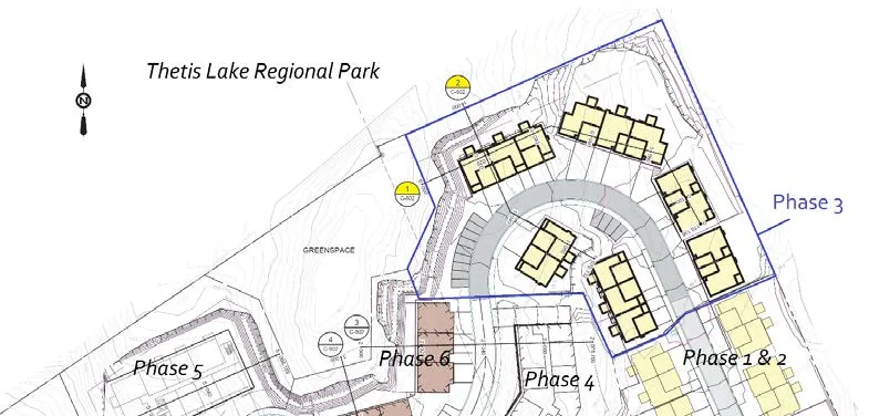
DISCUSSION:
- Relevant development permit guidelines
- Zoning requirements
- On-site servicing
1. Development Permit Area Guidelines
Mixed Residential Development Permit Area (Form and Character)
a. The form and massing of buildings will be similar to Phases 1 and 2.
- contemporary West Coast treatment: natural toned cementitious materials, mullioned window treatments, extensively glazed entry doors and windowed garage doors b. Cladding includes horizontal plank and board & batten to provide variety and texture. In Phase 3, stone type cladding elements are introduced on Blocks L, N, O and P, which provides a substantial and higher quality finish. c. Buildings arranged to follow the central driveway, which has been designed to minimize steep gradients as it traverses the sloping topography. d. Lighting will be dark skies friendly. Street lighting will be LED, which provides good directed illumination, and will be located on the side of the main driveway furthest away from the park to minimize light intrusion.
Sensitive Terrestrial Ecosystems Development Permit Area (Environmental and Hazard)
- Already addressed in previous DPs: a. environmental impact and mitigation measures including steep slope and interface fire hazard management b. Clearing, blasting, and grading of this Phase 3 site with measures to: 1. Protect retained trees on the periphery (and in the park) 2. Address geotechnical / steep slope hazard management 3. Control sediment and erosion
- Interface fire hazard management requirements are addressed by including the following requirements as conditions: a. Keeping 10m low fire fuel areas between buildings and the forest edge b. Use of fire-resistant roofing and cladding materials c. Enclosed metal soffits d. Buildings to be sprinklered
2. Zoning
General
| Section | Description – CD-23 zone | Required | Proposed |
|---|---|---|---|
| 12.23.3. | Lot Size, minimum | 4000m² | 42,580 m² |
| 12.23.3. | Total number of residential units on all lands zoned CD-23 | Max 350 | Existing: 178 + Proposed Ph. 3: 15 Total: 193 |
| 12.23.3. | Total Floor Space Ratio on all lands zoned CD-23 Total CD-23 land area: 51,930m² |
0.78:1 | Existing: 10,200m² + Proposed: 2398m² Floor space: 12,598m² Total CD-23 FSR: 0.25:1 |
| 12.23.3. | Floor Space Ratio on 1950 West Park Lane for Residential, Townhouse or Residential, Duplex use Lot area: 42,580m² |
0.5:1 | Existing: 4827m² + Proposed: 2398m² Floor space: 7225m² Total lot FSR 0.17:1 |
| 12.23.3. | Lot Coverage, maximum | 50% (21297.6m²) | 17.4% (7408.92 m2) |
Setbacks
| CD-23 zone | Front Lot Line setback (West Park Lane) | Rear Lot Line setback | Side Lot Line setback (Thetis Lk Park) | Setback to Thetis Lake Park |
|---|---|---|---|---|
| Required | Min. 6.0m | min. 6.0m | Min. 4.5m | Min. 10.0m |
| Block L | >60.0m | >60.0m | 10.0m | 10.0m |
| Block M | >60.0m | >40.0m | 10.2m | 10.2m |
| Block N | >60.0m | 12.9m | 13.9m | 13.9m |
| Block O | >60.0m | 14.8m | >30.0m | >30.0m |
| Block P | >60.0m | >60.0m | >40.0m | >40.0m |
| Block Q | >60.0m | >40.0m | >50.0m | >50.0m |
Other
| Section | Description | Required | Proposed | Variance |
|---|---|---|---|---|
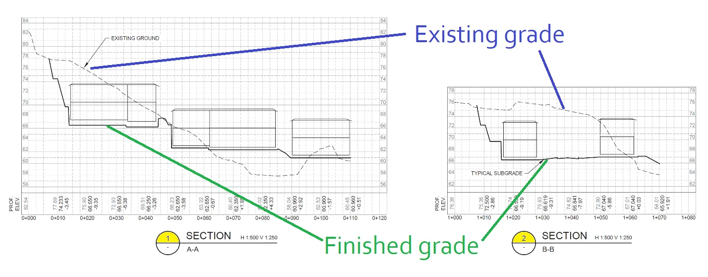
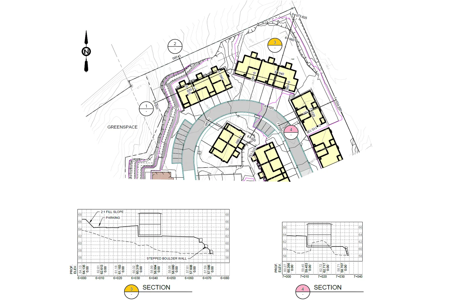
| 2.2 | Definition of Grade | Weighted average of the existing grade or the finished grade, whichever is lower | Avg finished grade as designated on plans | Avg finished grade as designated on plans |
| 5.2.2 (e) | Maximum gradient and cross slope parking | 6 % residential zones | <6% |
3. Servicing
- In 2019, water, sanitary sewer, and storm drain connections were installed at West Park Lane to accommodate the overall development.
- Site and servicing access is by easement over the adjoining parcel at 1910/1920 West Park Lane. A central driveway connects the phases.
- An erosion and sediment control plan was provided for this phase. The following is required prior to approval of the development permit: a. Confirm through engineered calculations that the sewer and drain connection is adequately sized for the proposed development b. Confirm that stormwater detention infrastructure installed during Phases 1 and 2 are sufficiently built to meet Town’s bylaw requirements.
- A master erosion and sediment control plan has been prepared by the Applicant’s engineer to streamline for management of this aspect in future phases of clearing and building.
RECOMMENDATION (page 1 of 2):
THAT Development Permit No. 2021/01 be approved as per the April 15, 2021 report from the Senior Planner titled “Development Permit Application No. 2021/01 – 1950 West Park Lane - Phase 3.”
AND THAT Development Permit No. 2021/01 include approval of a variance to the definition of grade from “the weighted average of the existing grade or the finished grade, whichever is lower” to “the average finished grade as designated in the November 20, 2020 Plans prepared by Java Designs.”
RECOMMENDATION (page 2 of 2):
AND FURTHER THAT Development Permit No. 2021/01 include the following conditions: a. Environmental impacts and mitigation measures including steep slope and interface fire hazard management be implemented in accordance with Development Permit No. 2019/02. b. Landscape planting and irrigation is to be installed in accordance with current BCSLA/BCNTA Standards. c. A security deposit for hard and soft landscaping is required prior to building permit issuance. d. The security deposit of $50,000 provided in Development Permit No 2019/02 to address any unsafe conditions or damage to the natural environment apply to works authorized in this development permit. e. This development permit does not authorize any retaining walls over 1.2m in height.
Document Images
(1)