Planning & Development Report: Development Permit Application 2020/05 - 1950 West Park Lane
Report for a proposed 26-unit multifamily development across 11 buildings, including a request for multiple variances.
TOWN OF VIEW ROYAL
Planning & Development Report
TO: Committee of the Whole DATE: May 12, 2020 FROM: J. Chow, Senior Planner MEETING: May 19, 2020 FILE NO.: 3060-20-2020/05
DEVELOPMENT PERMIT APPLICATION 2020/05 - 1950 WEST PARK LANE
RECOMMENDATION:
THAT the report dated May 12, 2020 from the Senior Planner titled “Development Permit Application 2020/05 - 1950 West Park Lane” be received for information.
CHIEF ADMINISTRATIVE OFFICER’S COMMENTS:
I concur with the recommendation.
DIRECTOR OF DEVELOPMENT SERVICES’ COMMENTS:
I concur with the recommendation.
DIRECTOR OF ENGINEERING’S COMMENTS:
I concur with the recommendation.
DIRECTOR OF PROTECTIVE SERVICE’S COMMENTS:
I concur with the recommendation.
PURPOSE:
- To introduce a development permit application to construct a multifamily development comprised of 26 residential units in 11 buildings blocks.
- To seek comments on the proposal and the requested variances.
- The determine what additional information may be needed for consideration of the application.
BACKGROUND:
The 4.26 ha parcel is north of Trans Canada Highway and backs on to Thetis Lake Regional Park as shown in Attachment 1. The west half of the parcel is primarily hilly, forested terrain with a rocky hilltop. Thetis Lake Campground operated for decades on the east half of the property and vacated the site in 2018. Access is from West Park Lane through an easement over 1910/1920 West Park Lane.
The parcel is part of a comprehensive development with recent development history as follows:
2017 OCP Amendment and Rezoning:
- OCP land use re-designation from “Parks Recreation and Open Space” to “Residential”.
- Inclusion in the Mixed Residential Development Permit Area and the Sensitive Terrestrial Ecosystems Development Permit Area.
- Rezoning from C-6: Tourist Commercial (Campground) to CD-23 Comprehensive Development (Thetis Lake).
The applicant provided community amenities consisting of 5.12 ha of land adjacent to Mill Hill Regional Park and sidewalk improvements on both Six Mile Road and West Park Lane.
Development Permit 2019/02
- Permit subdivision into two lots (subject property and 1910/1920 West Park Lane)
- Pre-clearing and grading of this stage of the development
- Tree retention/protection measures
- Guidelines to manage the wildland/urban interface fire hazard.
Development Permit 2019/03 A development permit was approved to construct 152 multifamily residential units in two six-storey mixed affordability rental apartment buildings at 1910 / 1920 West Park Lane. The buildings are under construction.
PROPOSAL:
The proposal is to construct the following at south east portion of the parcel:
- 26 units of multifamily residential units in four triplex townhouse blocks and seven duplex blocks as shown in Attachment 4.
- A private playground area for the residents of 1950 West Park Lane and 1910/1920 West Park Lane.
This would be the initial stage of a phased strata development with six phases (see Figure 1). This development permit would comprise Phases 1 and 2. The common driveway though this initial stage would provide access for the future phases. The development concept for future phases is multifamily residential uses (including two apartment buildings) and two private green space areas. A phased strata is one where temporary phasing boundaries (which function like lot lines) are established, but the end development is all part of the same strata sharing decision making and the costs of maintaining the infrastructure that serves all of the parties.
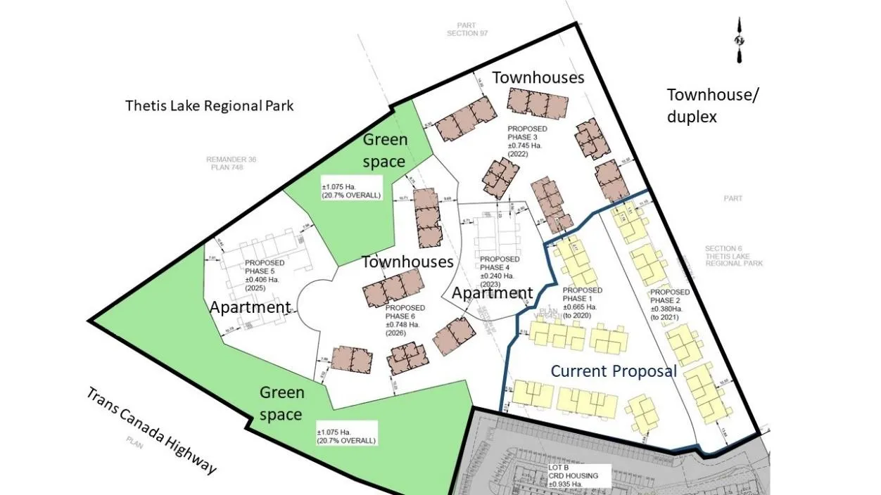
Figure 1. Development concept (subject to revision)
In support of the application the following is provided as attachments to this report:
- Location Map
- Letter from Applicant
- Phasing Plan
- Site and Building Design
- Site Sections
- Landscape Plan
- Fence Plan
- Grading Plan
- Exterior Materials
- Lighting Plan
- Building Renderings
- Servicing Plan
- Geotechnical overview
Servicing
Water, sanitary sewer, and storm drain connections were installed at West Park Lane to accommodate the overall development when this parcel was subdivided in 2019.
DISCUSSION:
Key issues include the following:
- How does the proposal address the relevant development permit guidelines?
- How does the proposal comply with zoning requirements?
- What are the next steps toward Council consideration of the proposal?
1. Development Permit Area Guidelines
Mixed Residential Development Permit Area The proposal generally complies with the Mixed Residential Development Permit Area guidelines as detailed in Attachment 14.
a. The massing of buildings will be similar to the multifamily dwellings at Massey Place in Thetis Vale but with a more contemporary West Coast treatment through the arrangement of natural toned cementitious materials, mullioned window treatments, entry doors and windowed garage doors as shown in Figure 2. b. The buildings will step up with topography as the central driveway rises (see Figure 3). Triplex blocks will have one unit stepped to provide match the slope and reduce the massing. The slope necessitates window wells for basement level bedrooms in Block G, H, J and K and there will be walkable grates over top for safety. c. Lighting will be dark skies friendly. Street lighting will be LED, which provides good directed illumination, and will be located on the side of the main driveway furthest away from the park to minimize light intrusion.
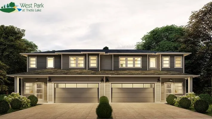
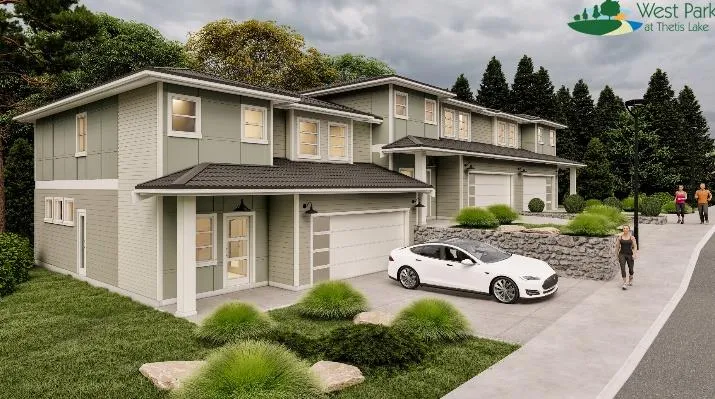
Figure 2. Block B rendering Block F rendering
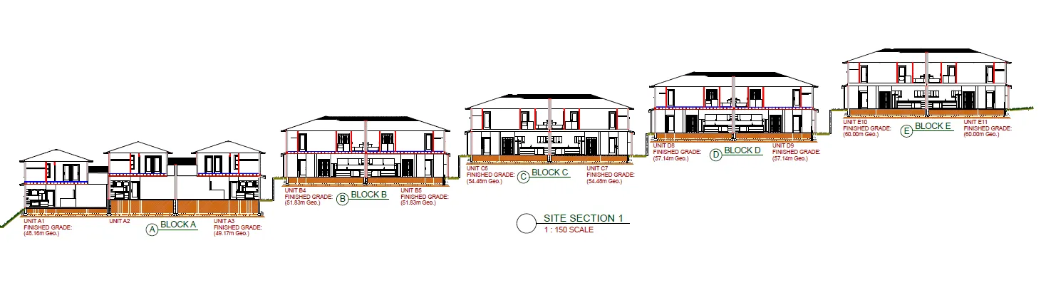
Figure 3. Site Cross Section (View from east)
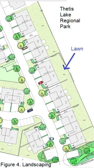
The guidelines do not support large expanses of lawn. The most notable example of this along the east boundary bordering Thetis Lake Regional Park.
Staff considers that the amount of lawn proposed along the east boundary as shown in Figure 4 as the main aspect of the development that is not in accordance with guidelines. The CD-23 zone requires a building setback of 10m from the Thetis Lake Regional Park boundary. This large 10m setback was instituted to create a spatial buffer between residents and park uses and is also the distance required by Development Permit 2019/02 to be kept fuel free (clear of twigs, dry grass, logs and leaves) to mitigate wildland/urban interface fire risks. The FireSmart report in that permit allows the use of fire-resistant shrubs. CRD Regional Growth Strategy also supports policies for buffering and land use transition between settled areas and places like this park which is in the Capital Green Lands. Staff does not support the hard transition from lawn to park. There is ample area for a buffer of primarily native, fire-resistant shrubs that would also help lawn grasses from escaping into the park through the chain link fence.
Additional considerations and information that should be provided are listed in Section 3 (Next Steps) of this report. No signs are proposed at this time.
Sensitive Terrestrial Ecosystem Development Permit Areas Environmental impacts and mitigation measures including steep slope and interface fire hazard management are set out in Development Permit DP2019/02 and will be referenced as requirements for this development. Development Permit 2019/02 allowed preclearing of this site with measures to protect retained trees on the periphery. This proposal complies with the interface fire hazard management requirements of the development permit through the following:
- Clearing 10m low fire fuel areas between buildings and the forest edge
- Use of fire-resistant roofing and cladding materials
- Enclosed metal soffits
- Buildings to be sprinklered
A preliminary geotechnical review (Attachment 13) indicates no significant concerns currently.
2. Zoning
The proposal complies with the use and density requirements CD-23: Comprehensive Development (Thetis Lake) zone as shown in Attachment 13. Variances to other zoning requirements are shown in Table 1.
Table 1. Summary of Variances
| Section | Description | Required | Proposed | Variance |
|---|---|---|---|---|
| 2.2 | Definition of Grade | Weighted average of the existing grade or the finished grade, whichever is lower | Finished grade as designated on plans | |
| 4.8.9 | Retaining wall height | Max 1.2m | 2.7m | 1.5m |
| 5.2.2 (e) | maximum gradient and cross slope of parking spaces | 6 % residential zones | 8.9% in driveways | 3% |
| 5.5.1 (c) | Width of parking space adjacent to a wall, pillar, planter or other obstruction | Additional 0.3m width | Visitor parking off main d/w at Blocks K and M | |
| 12.23.3 | Side lot line setback | Min. 4.5m | Blk K 4.2m | 0.3m |
| Blk E 1.2m | 3.3m | |||
| Blk F 2.1m | 2.4m | |||
| 12.23.3 | Side lot line setback | Min 4.5m | 1.2m Block E & F | 4.8m |
Variances
a. Defining grade through the grading plan rather than average grade The proposed variance to measure each building’s height from finished grade in the grading plan rather than the lower of the average finished and natural grades can be supported. This is administratively more efficient on a site that has been extensively re-graded but requires the property owner commit to the grading plan. The Town’s experience at Thetis Vale for this type of situation has been successful.
b. Retaining Wall height The variance to increase retaining wall height from 1.2m to 3.0m can be supported because extensive grading was necessary for the site layout. Building sites can then step up along the sloping site. There is insufficient area on the proposed site layout to separate retaining walls into 1.2m tiers between buildings as shown in Figure 3.
c. Maximum gradient and cross slope of parking spaces The proposal to vary the maximum gradient of driveway parking spaces from 6% to 9% can be supported as it only applies to five required driveway spaces at Blocks A-E and they are in locations where there should be door swing clearance to avoid vehicle damage. This is due to the difference between the slope of the main driveway and the building grade as the main driveway rises across a building frontage. The applicant has done extensive design work. Confirmation of the cross slope is required.
d. Width of parking space beside wall There is insufficient clearance from retaining walls for two visitor parking spaces off the main driveway at Blocks K and M as shown Figure 5. Additional clearance should be provided. For a site such as this it is beneficial to have designated visitor parking as the road width does not permit on street parking. The strata will be responsible for maintaining these spaces for the use and benefit of the strata.
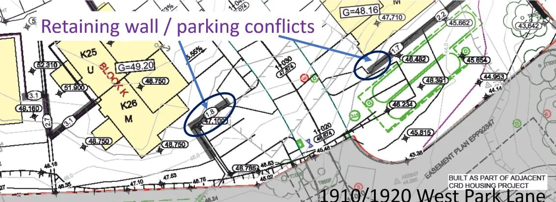
Figure 5. Visitor parking at site entrance
e. Setbacks The proposal to vary the side lot line setback for Block K from 4.5m to 4.2m as shown in Figure 6 can be supported because of site constraints, it is only for one corner of the building and because it is adjacent to surface parking on the at 1910/1920 West Park Lane. Neighbouring residents would not be affected.
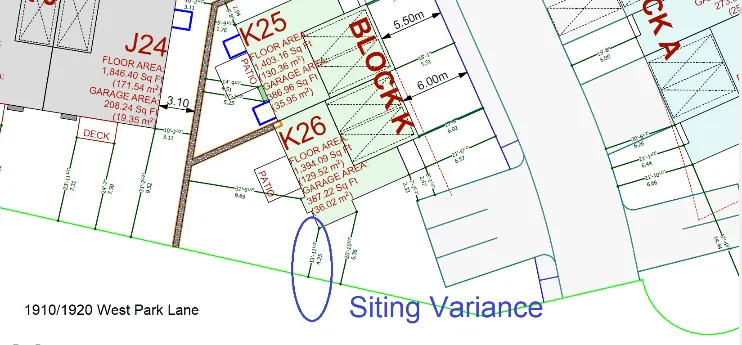
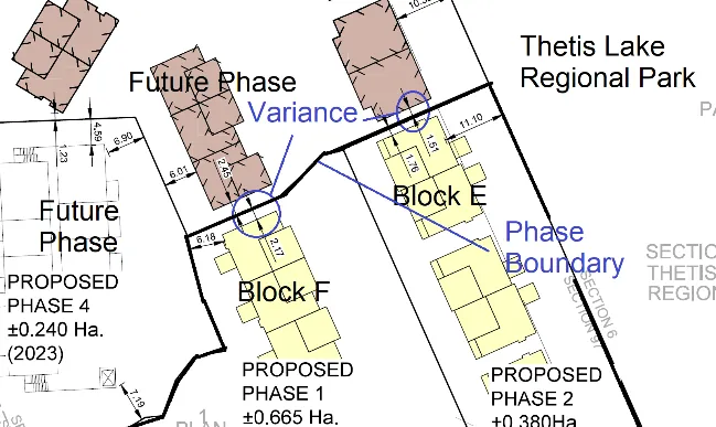
Figure 6. Block K side yard setback Figure 7. Block E&F side lot line (phase boundary)
The proposal to vary the side lot line setback for Blocks E and F from 6.0m to 1.5m as shown in Figure 7 can be supported because phased stratas consider temporary phase boundaries as lot lines. When the next phase is developed, this line would no longer exist when the phase joins the strata plan.
3. Next Steps
Further information should be provided prior to Council consideration as follows:
Development Permit Area Guidelines a. Additional fire-resistant shrubs should be provided to adjacent to the park boundary to provide screening and a transition between the development and the park. Lawn areas should be reduced and ideally should not directly abut Thetis Lake Park. b. A 1.9-2.0m chain link fence along the east boundary abutting Thetis Lake Regional Park would better address Crime Prevention Through Environmental Design (CPTED) principles than the proposed 1.5m chain link fence. c. Show cedar fence plan details d. Landscape plan a. Note planting to be done in accordance with current BCSLA/BCNTA Standards b. If an irrigation kiosk is proposed, please show on plans c. What is patio surface? Will patios have fencing or screening? e. Provide a cost estimate for hard and soft landscaping, excluding playground f. Show pad mounted transformer locations (and how they can be screened) on architectural, servicing, and landscaping site plans. g. Confirm if there will be any mechanical equipment on the roofs. If so, show how they will be screened. h. If solid waste and recycling storage will be centralized, please show on plans. i. Commitment to an energy efficiency standard is supported, as is electric vehicle charging.
Zoning j. The cross slopes of required driveway parking spaces along the main driveway should be confirmed.
Other k. Consider a T-turnaround at the end of Lane B. Otherwise vehicles will have to back up all the way to the main driveway if every private driveway is occupied. l. If a community mailbox will be provided on site, it should be shown on the plans.
Staff will work with the applicant to resolve issues identified in this report and any comments arising from this Council meeting.
RECOMMENDATION:
THAT the report dated May 12, 2020 from the Senior Planner titled “Development Permit Application 2020/05 - 1950 West Park Lane” be received for information.
ATTACHMENTS
- Location plan – subject property Location Map
- Applicant Letter, April 6, 2020 (2 pages)
- Phasing Plan - Associate Engineering, May 1, 2020
- Site and Building Design, - Java Design, April 3, 2020 (58 pages)
- Site Cross Sections - Java Design, April 3, 2020 May 8, 2020 (2 pages)
- Landscape Plan, KMZ Landscapes, May 12, 2020
- Fence Plan - Associate Engineering, May 7, 2020
- Grading Plan – Associate Engineering, March 24, 2020
- Exterior Materials and lighting (5 pages)
- Lighting Plan – Primary Engineering and Construction (2 pages)
- Building Renderings (2 pages)
- Storm Water Management Plan – Associate Engineering, March 1, 2019 (22 pages)
- Geotechnical overview – Ryzuk Geotechnical, May 8, 2020
- Development Permit Guideline review (7 pages)
- Zoning Review (3 pages)
Document Images
(5)