Presentation - 1950 West Park Lane Development Permit Application 2020/05
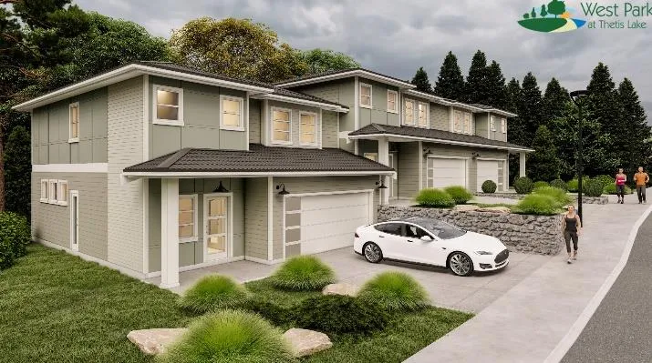
A staff presentation detailing the proposed 26-unit townhouse development at 1950 West Park Lane, including site plans, zoning requirements, and requested variances.
DEVELOPMENT PERMIT APPLICATION 2020/05
1950 West Park Lane
- To introduce a 26-unit townhouse development (triplexes/duplexes).
- To seek comments on the proposal and requested variances.
- To determine what additional information may be needed for consideration of the application.
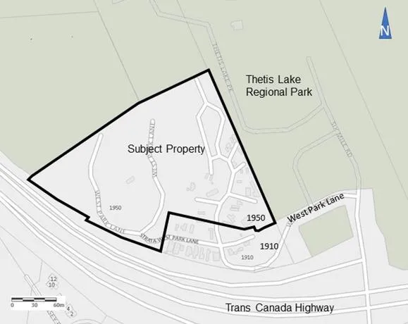
BACKGROUND:
- 2017 rezoned from C-6: Tourist Commercial (Campground) to CD-23 Comprehensive Development (Thetis Lake) to permit up to 350 units.
- Within Sensitive Terrestrial Ecosystems Development Permit Area to address the natural environment, wildland/urban interface and steep slopes.
- Within the Mixed Residential Development Permit Area to enable regulation of the form and character of multiple family residential development.
- Development Permit 2019/02 – to allow subdivision into two lots (subject property and 1910/1920 West Park Lane), pre-clearing and grading of subject with tree retention/protection measures, and establish guidelines to manage the wildland/urban interface fire hazard.
Development concept (subject to revision)
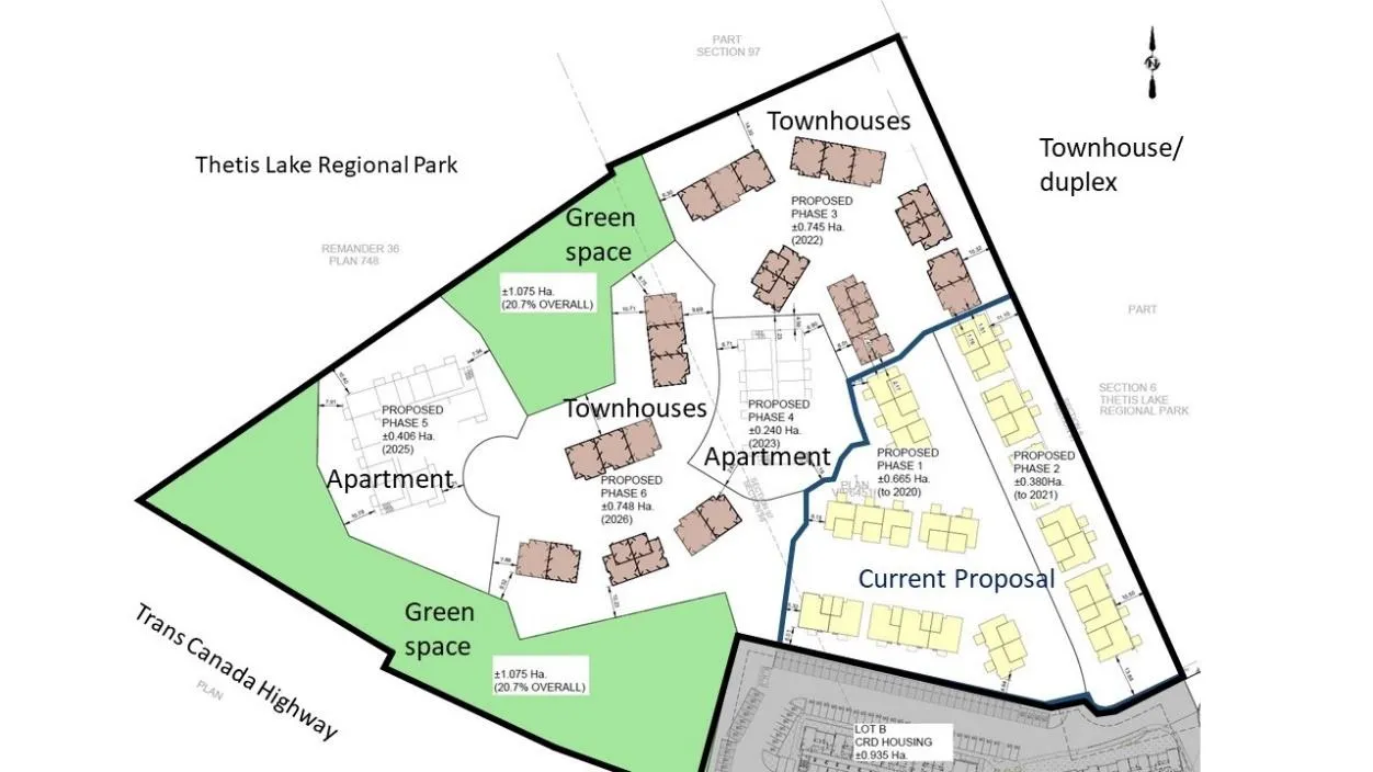
Future phases
DISCUSSION:
Key issues include the following:
- How does the proposal address the development permit guidelines?
- How does the proposal comply with zoning requirements?
- What are the next steps toward Council consideration of the proposal?
1. Development Permit Area Guidelines (1 of 4)
Mixed Residential Development Permit Area
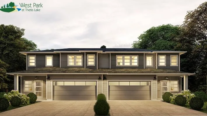
- Massing similar to the multifamily dwellings at Massey Place in Thetis Vale
- Natural toned cementitious materials (five schemes) with a more contemporary West Coast treatment of windows, entry doors and garage doors
1. Development Permit Area Guidelines (2 of 4)
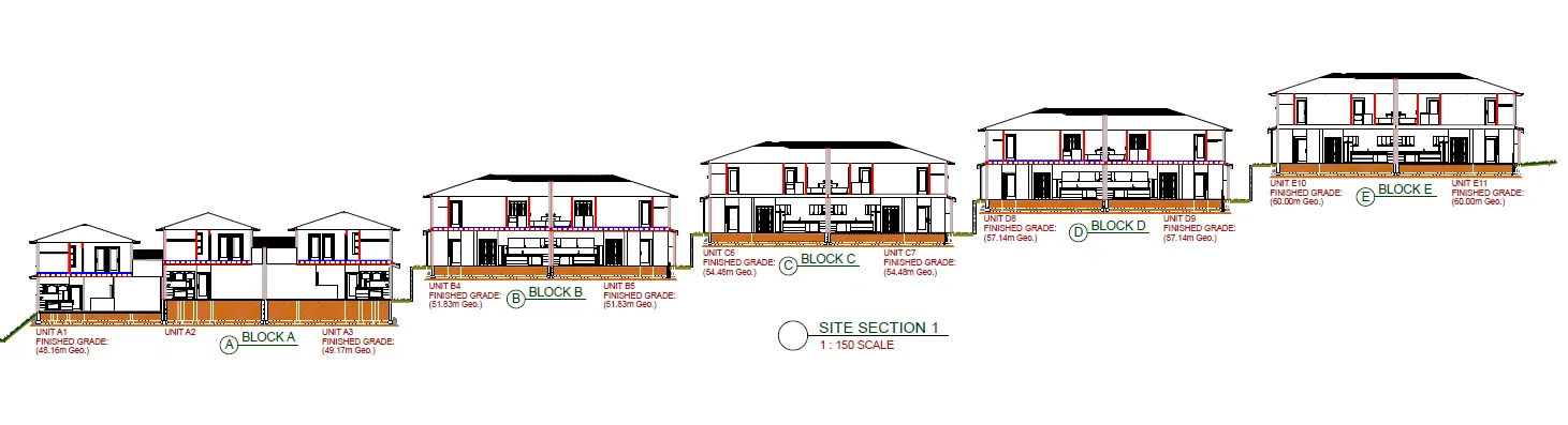
- Buildings step up with topography as the central driveway rises
- Triplex blocks will have one unit stepped to provide match the slope and reduce the massing.
- The slope necessitates window wells for basement level bedrooms at the rear or side of four blocks but there will be walkable grates over top for safety.
1. Development Permit Area Guidelines (3 of 4)
- 10m setback zoning/fire hazard setback at rear of Blocks A-E
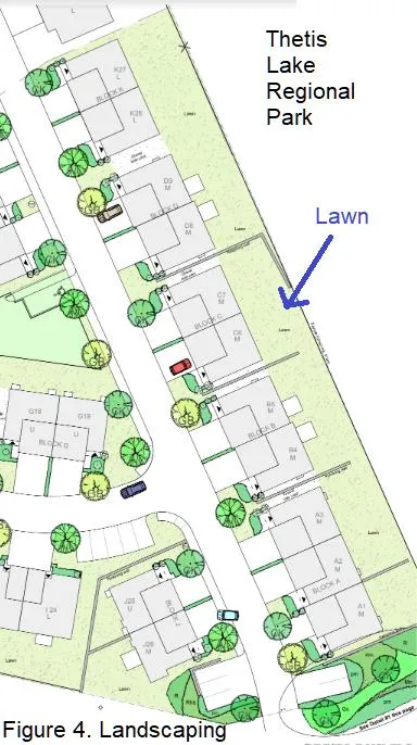
- Guidelines do not support large expanses of lawn.
- Staff does not support the hard transition from lawn to park
- Ample area for buffer of primarily native, fire-resistant shrubs. Garden bed for shrubs would also help lawn grasses from escaping into the park through chain link fence
- CRD Regional Growth Strategy supports policies for buffering and land use transition between settled areas and places like this park in the Capital Green Lands
- Other items in Next Steps
1. Development Permit Area Guidelines (4 of 4)
Sensitive Terrestrial Ecosystem Development Permit Areas
- Environmental impacts and mitigation measures including steep slope and interface fire hazard management are set out in Development Permit DP2019/02 and this development complies as follows:
- Measures are in place to protect retained trees on the periphery.
- Interface fire hazard management requirements of the development permit are addressed through the following:
- Clearing 10m low fire fuel areas between buildings and the forest edge
- Use of fire-resistant roofing and cladding materials
- Enclosed metal soffits
- Buildings to be sprinklered
- A preliminary geotechnical review indicates no significant concerns currently.
2. Zoning (Page 1 of 2)
| Description – CD-23 zone | Required | Proposed |
|---|---|---|
| Lot Size, minimum | 4000m² | 42,580 m² |
| Total number of residential units on all lands zoned CD-23 | Max 350 | Proposed Ph 1&2: 26 +1910/1920 West Park Lane: 152 Running total: 178 |
| Total Floor Space Ratio on all lands zoned CD-23: Comprehensive Development (Thetis Lake) Total land area: 51,930m² |
0.78:1 | Proposed: 4827.1m² + 1910/1920 West Park lane: 5373.0m² Running total:10,200.1m² Total FSR: 0.20:1 |
| Floor Space Ratio Phase 1 & 2 for Residential, Townhouse or Residential, Duplex use | 0.5:1 | Proposed Ph1&2 FS: 4827.1m² Ph1&2 land: 10450m² Ph1 FSR 0.47:1 |
| Lot Coverage | Max 50% | 13.3% |
| Impermeable Surface Coverage | Max 50% | 13.29% |
2. Zoning (Page 2 of 2)
| Parking requirements | Required | Proposed |
|---|---|---|
| Location from any lot line | > 1.2m | 1.7m |
| Size | Min. 2.6m wide, 5.5m length, 2.1m overhead clearance: | 2.6 wide 5.5m long |
| Small car spaces | Max 30% (exc. parallel), 2.4m wide, 4.8m long, marked | None |
| Townhouses 1.5 per unit | 1.5 per unit x 26 = 39 | 2/unit: 52 Visitor: 11 Total: 63 |
| Rowhouse, Townhouse: • Class 1 bike parking: 1 per unit |
Class 1: 1 per unit | In garage |
| Electric vehicle charging station | One per commercial or multiple unit residential development that requires more than 100 parking spaces | Future phases will require |
Variances
| Description | Required | Proposed | Variance |
|---|---|---|---|
| Definition of Grade | Weighted average of the existing grade or the finished grade, whichever is lower | Finished grade as designated on plans | |
| Retaining wall height | Max 1.2m | 2.7m | 1.5m |
| maximum gradient and cross slope of parking spaces | 6 % residential zones | 8.9% in driveways | 3% |
| Width of parking space adjacent to a wall, pillar, planter or other obstruction | Additional 0.3m width | Visitor parking off main driveway at Blocks K and M | 0.3m |
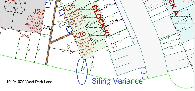
| Side lot line setback | Min. 4.5m | Blk K 4.2m | 0.3m |
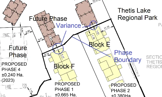
| Rear lot line setback | Min 6.0m | Blk E 1.2m Blk F-2.1m |
4.8m 3.9m |
Variances (1 of 4)
a. Defining grade through the grading plan rather than average grade
- Administratively more efficient on a site that has been extensively re-graded
- Requires the property owner commit to the grading plan.
- Town’s experience at Thetis Vale for this type of situation has been successful.
b. Retaining Wall height
- Extensive grading was necessary so building sites can now step up along the sloping site.
- Insufficient area to terrace retaining walls into 1.2m tiers between buildings.
c. Maximum gradient and cross slope of parking spaces
- Variance to maximum gradient of driveway parking spaces from 6% to 9% only applies to five required driveway spaces at Blocks A-E
- Due to the difference between the slope of the main driveway and the building grade as the main driveway rises across a building frontage.
- Extensive design work to ensure locations with door swing clearance or hedge to avoid vehicle damage.
Variances (2 of 4)
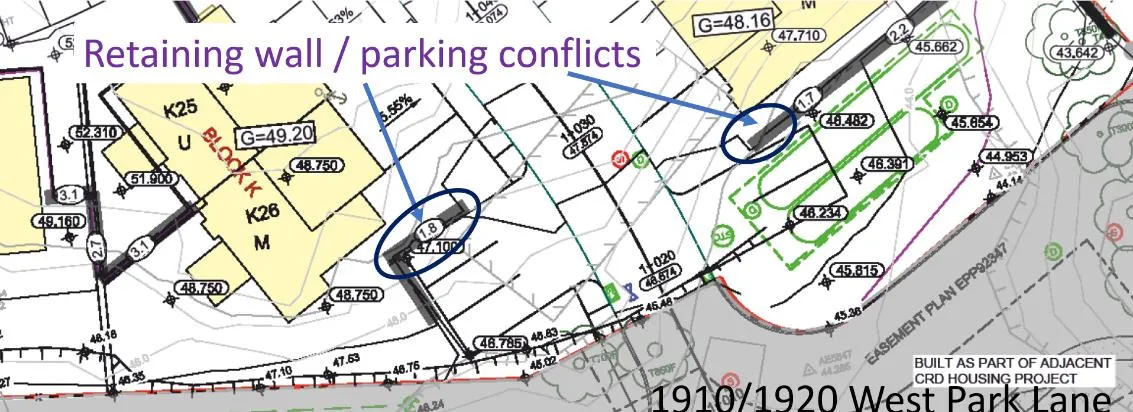
d. Width of parking space beside wall
- Insufficient clearance from retaining walls for two visitor parking spaces at Blocks K and M. Needs to be resolved.
Variances (3 of 4)
e. Setbacks
- Variance the side lot line setback for Block K from 6.0m to 4.2m due to site constraints
- Only for one corner of the building - adjacent to surface parking on the at 1910/1920 West Park Lane - neighbouring residents would not be affected.
Variances (4 of 4)
e. Setbacks continued
- Variance the rear lot line setback for Blocks E and F from 6.0m to 1.5m because phase boundaries in phased stratas are considered as lot lines even though they are ‘temporary’.
- When the next phase is developed, this line would no longer exist when the phase joins the strata plan.
3. Next Steps (page 1 of 3)
Further information should be provided prior to Council consideration as follows:
Development Permit Area Guidelines
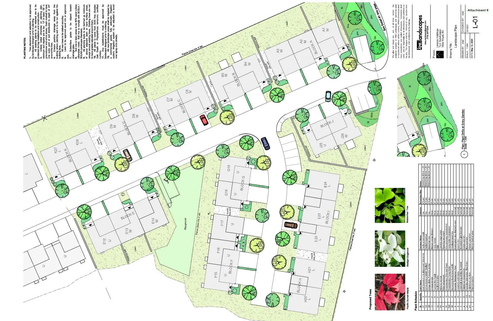
a. Additional fire-resistant shrubs should be provided to adjacent to the park boundary to provide screening and a transition between the development and the park. Lawn areas should be reduced and ideally should not directly abut Thetis Lake Park. b. A 1.9-2.0m chain link fence along the east boundary abutting Thetis Lake Regional Park would better address Crime Prevention Through Environmental Design (CPTED) principles than the proposed 1.5m chain link fence. c. Show cedar fence plan details d. Landscape plan i. Note that planting is to be done in accordance with current BCSLA/BCNTA Standards ii. If an irrigation kiosk is proposed, please show on plans iii. What is patio surface? Will patios have fencing or screening?
3. Next Steps (page 2 of 3)
e. Provide a cost estimate for hard and soft landscaping, excluding playground f. Show pad mounted transformer locations (and how they can be screened) on architectural, servicing, and landscaping site plans. g. Confirm if there will be any mechanical equipment on the roofs. If so, show how they will be screened. h. If solid waste and recycling storage will be centralized, please show on plans. i. Commitment to an energy efficiency standard is supported, as is electric vehicle charging.
Zoning
j. The cross slopes of required driveway parking spaces along the main driveway should be confirmed.
2. Next Steps (page 3 of 3)
Other
k. Consider a T-turnaround at the end of Lane B. Otherwise vehicles will have to back up all the way to the main driveway if every private driveway is occupied. l. If a community mailbox will be provided on site, it should be shown on the plans.
Staff will work with the applicant to resolve issues identified in this report and any comments arising from this Council meeting.
RECOMMENDATION:
That the May 12, 2020 report from the Senior Planner titled “Development Permit Application 2020/05 - 1950 West Park Lane” be received for information.
Document Images
(1)