Appendix A - FUS Calculations / CRD Information
Technical calculations for fire flow requirements and water system mapping/curves from the CRD.
Appendix A
- FUS Calculations
- CRD Information

FUS Calculations
PROJECT: 289 Island Hwy. CLIENT: Glentanna Date: August 21, 2020 File: 32668
Type of Construction: Mixed Coefficient (C) based on type of construction = 1.2 Total Floor Area: 4,886 m² Fire Flow From Formula ($F = 220 \cdot C \cdot A^{0.5}$): 18,453 L/min. (a) $\Rightarrow$ 18,000
Type of Occupancy: low Hazard: Hazard Allowance: <25%> (a) = <4,500> L/min. Sub-Total: 13,500 L/min. (b)
Automatic Sprinklers: Yes Sprinkler Allowance: 50% x (b) = 6,750 L/min. (c)
Exposures:
- North: 15 m (Separation) | 7 percent (Max. Charge)
- South: >45 m (Separation) | 0 percent (Max. Charge)
- East: 20 m (Separation) | 10 percent (Max. Charge)
- West: >20 m (Separation) | 10 percent (Max. Charge)
Exposure Allowance (75% Maximum): 27% x (b) = 3,645 L/min. (d)
TOTAL FIRE FLOW REQUIRED: (rounded) 10,395 L/min. (b-c+d) $\Rightarrow$ 10,000 TOTAL FIRE FLOW REQUIRED: 167 L/s
Construction Coefficient
- C=1.5, Wood Frame
- C=1.0, Ordinary (brick or other masonry walls, combustible floor and interior)
- C=0.8, Non-Combustible (unprotected metal structural components, masonry or metal walls)
- C=0.6, Fire-Resistive (fully protected frame, floors, roof)
- Floor Area includes all storeys, excluding basements at least 50% below grade
Hazard Allowance
- -25% dwellings, apartments
- -20% hospitals, elem. schools
- -15% high schools
- (*) Values to nearest L/minute
Separation and Maximum Charge
| (1) Separation | (2) Max. Charge |
|---|---|
| 0 to 3 m | 25% |
| 3.1 to 10 m | 20% |
| 10.1 to 20 m | 15% |
| 20.1 to 30 m | 10% |
| 30.1 to 45 m | 5% |
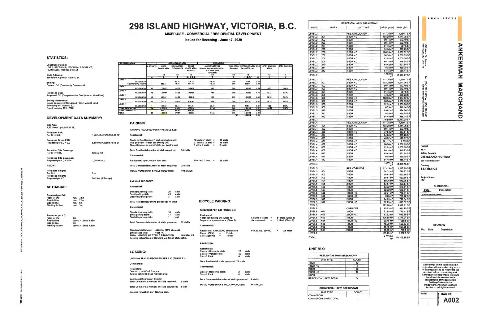
Development Data Summary
Address: 298 Island Highway, Victoria, B.C. Issued for Rezoning: June 17, 2020
Statistics
- Legal Description: LOT 1, SECTION 8, ESQUIMALT DISTRICT, PLAN 35505, PID 000-348-554
- Civic Address: 298 Island Highway, Victoria, BC
- Zoning (Current): C-1 (Community Commercial)
- Proposed Use: CD (Comprehensive Development - Mixed Use)
Development Data Summary
- Site Area: 1,853.00 m² (19,945.53 SF)
- Permitted FSR (Per C-1 = 0.8): 1,482.40 m² (15,956.42 SF)
- Proposed Gross FSR (Per CD = 3.0): 5,559.00 m² (59,838.58 SF)
- Permitted Site Coverage (Per C-1 = 50%): 926.50 m²
- Proposed Site Coverage (Per CD = 75%): 1,391.00 m²
Height
- Permitted Height (Per C-1): 9 m
- Proposed Height (Per CD): 20.23 m (8 Storeys)
Setbacks
| Orientation | Required per C-1 | Proposed per CD |
|---|---|---|
| Front lot line | min. 7.5m | 0m |
| Rear lot line | min. 7.5m | varies 3.12m to 3.95m |
| Side lot line | min. 6m | 0m |
| Flanking lot line | min. 3m | varies 3.12m to 4.33m |
FSR Calculation Table
| LEVEL | # OF UNITS | GROSS FLOOR AREA (m²) (D) | EXCLUSIONS (m²) (E) | NET FLOOR AREA FSA (m²) (G=D-E) | OPEN BALCONY AREA (m²) |
|---|---|---|---|---|---|
| LEVEL 1: RESIDENTIAL | - | 128.72 | 48.38 | 80.34 | 0.00 |
| LEVEL 1: COMM. RETAIL | 1 | 654.49 | 46.52 | 606.87 | 0.33 |
| LEVEL 2: RESIDENTIAL | 12 | 1,164.59 | 1.69 | 1,162.89 | 0.63 |
| LEVEL 3: RESIDENTIAL | 12 | 1,164.59 | 1.69 | 1,162.90 | 72.34 |
| LEVEL 4: RESIDENTIAL | 12 | 1,098.42 | 1.69 | 1,096.73 | 79.50 |
| LEVEL 5: RESIDENTIAL | 11 | 874.96 | 1.69 | 873.28 | 18.15 |
| LEVEL 6: RESIDENTIAL | 7 | 604.25 | 28.21 | 576.04 | 0.31 |
| TOTAL RESIDENTIAL | 54 | 5,035.54 | 81.35 | 4,952.19 | 169.99 |
| TOTAL COMMERCIAL | 1 | 654.49 | 46.52 | 606.87 | 0.33 |
| TOTAL | 55 | 5,559.03 | 81.35 | 5,558.18 | 169.99 |
Calculated FSR: 3.00
Parking Requirements (Per 5.10, Table 5.2)
Residential:
- Studio or One Bedroom: 1 stall per unit (16 units) = 16 stalls
- Two Bedroom: 1.5 stalls per unit (37 units) = 56 stalls
- Three Bedroom or more: 2 stalls per unit (1 unit) = 2 stalls
- Total Residential required: 74 stalls
Commercial:
- Retail store: 1 per 20 m² (559.3 m²) = 28 stalls
- Total Commercial required: 28 stalls
TOTAL NUMBER OF STALLS REQUIRED: 102 STALLS
Parking Proposed
Residential:
- Standard: 26 stalls
- Small: 49 stalls
- Disability: 2 stalls
- Total Residential proposed: 77 stalls
Commercial:
- Standard: 18 stalls
- Small: 13 stalls
- Disability: 1 stall
- Total Commercial proposed: 32 stalls
TOTAL NUMBER OF STALLS PROPOSED: 109 STALLS Standard stalls total: 44 (40%) (30% allowed) Small stalls total: 62 (57%) Seeking relaxation on Standard v.s. Small stalls ratio.
Bicycle Parking (Per 5.11, Table 5.4)
Residential Required:
- 1 stall per unit (Class 1): 54 stalls
- 6-space rack per entrance (Class 2): 1 Rack
Commercial Required:
- Retail store: 1 per 250 m² (654.49 m²) = 2.6 stalls
- Class 1 (50%): 2 stalls
- Class 2 (50%): 1 stall
Bicycle Parking Proposed:
- Residential: 73 stalls (27 Horizontal, 39 Vertical, 6 Rack)
- Commercial: 8 stalls (2 Horizontal, 6 Rack)
- TOTAL NUMBER OF STALLS PROPOSED: 81 STALLS
Loading Requirements (Per 5.10, Table 5.3)
Commercial:
- Requirement: Two spaces for 500 m² to 2,500 m² retail area.
- Total Commercial number of stalls required: 2 stalls
- Total Commercial number of stalls proposed: 1 stall
- Seeking relaxation on 1 loading stall.
Unit Mix Breakdown
| UNIT TYPE | COUNT |
|---|---|
| 1 BDR | 12 |
| 1 BDR + D | 4 |
| 2 BDR | 20 |
| 2 BDR + D | 17 |
| 3 BDR | 1 |
| RESIDENTIAL UNITS TOTAL | 54 |
| COMMERCIAL UNITS TOTAL | 1 |
Residential Area Breakdown Totals
- LEVEL 2 TOTAL: 1,162.89 m² (12,517.27 SF)
- LEVEL 3 TOTAL: 1,162.9 m² (12,517.38 SF)
- LEVEL 4 TOTAL: 1,096.73 m² (11,805.15 SF)
- LEVEL 5 TOTAL: 873.28 m² (9,399.91 SF)
- LEVEL 6 TOTAL: 563.23 m² (6,062.6 SF)
- TOTAL: 4,859.04 m² (52,302.29 SF)
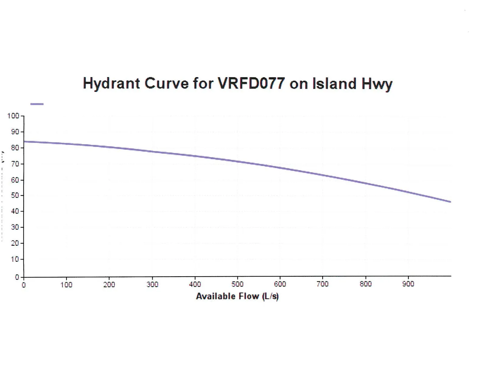
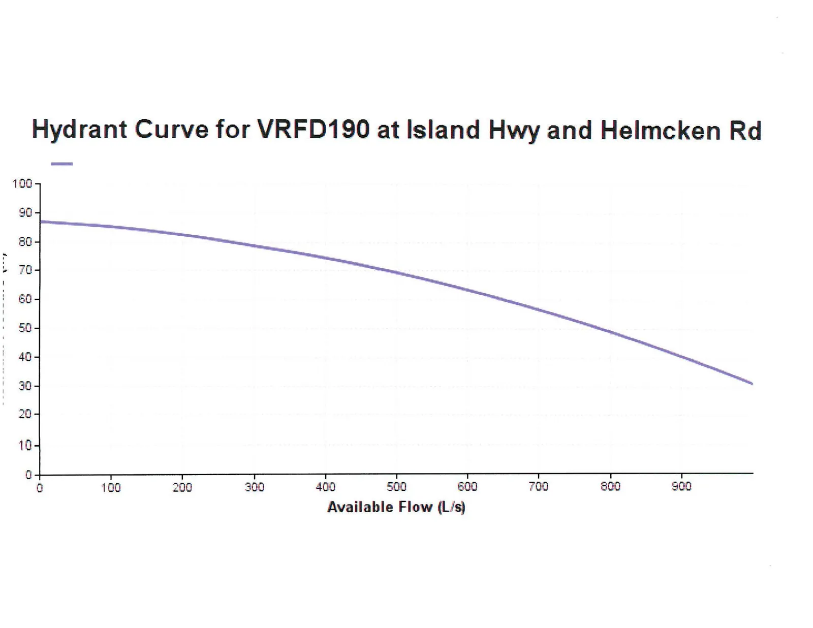
CRD Information
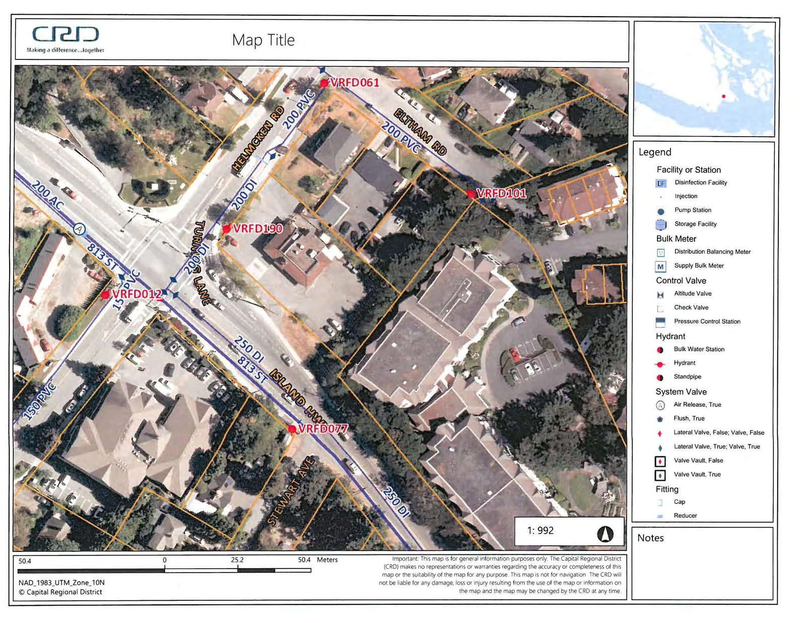
Hydrant Curve Information