Presentation: OCP2020/01 and REZONING 2020/04 - 298 Island Highway
A comprehensive staff presentation outlining the development concept, OCP amendments, and rezoning details for 298 Island Highway.
OCP2020/01 and REZONING 2020/04
298 Island Highway

OUTLINE
- Identified issues a. Contaminated Sites b. Public Consultation c. Confirmation of sewer pump station capacity d. Traffic Impact Assessment comments
- OCP Amendment
- Rezoning Bylaw (+covenant)
- Development Concept
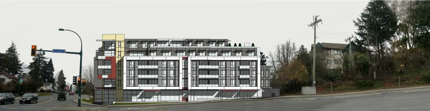
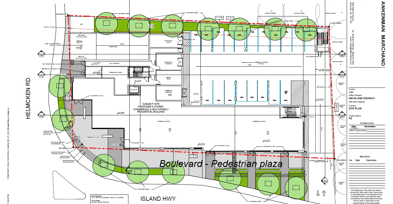
Island Highway frontage (proposed boulevard trees not shown)
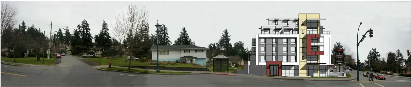
Helmcken Road frontage (proposed boulevard trees not shown)
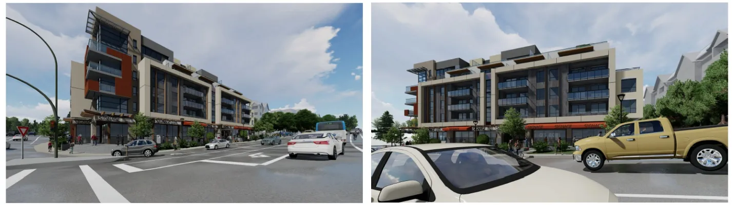
Perspectives from Island Highway
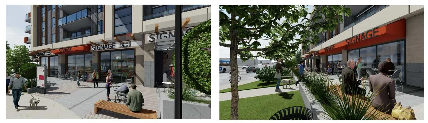
Plaza rendering
1. Identified Issues
a. Contaminated Sites
- approval from Provincial Land Remediation Section to proceed through rezoning process
b. Public consultation and notification
- April 2020 – door knocking campaign for residences within three blocks
- May 2020 - open house for 288/290 Island Highway (Lions Cove).
- October 2020 – over 500 flyers distributed to properties within the 400m public hearing notification radius, with website/email address setup to receive comments
c. Sewer lift station
- capacity confirmed
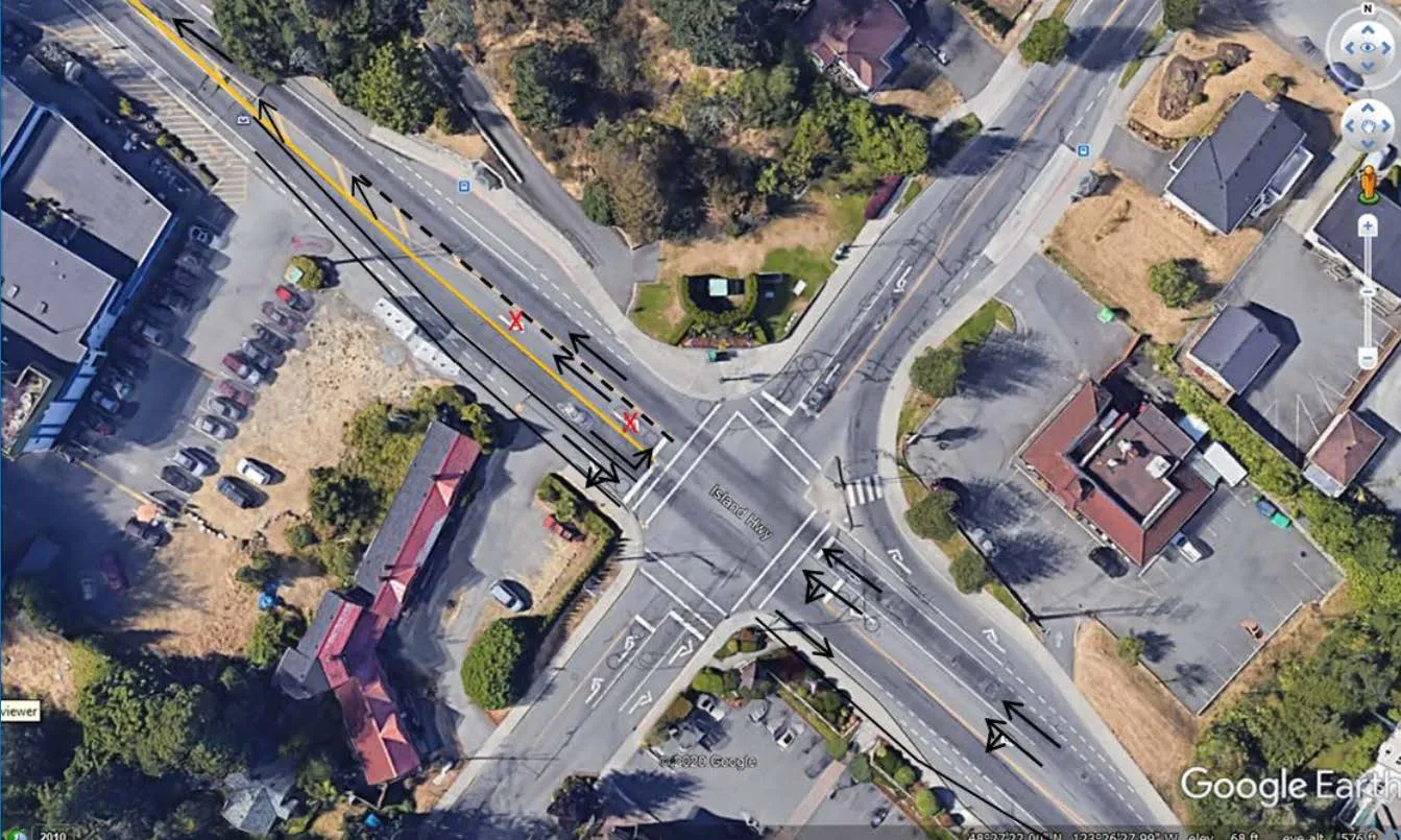
1.d Transportation Impact
- The assessment suggests long term (>10 years) lane changes to the Island Highway at the Helmcken Road intersection. Staff does not support this concept because:
- Although more vehicles would move through the intersection on each signal cycle, it would not improve the traffic volume through other intersections of the Island Highway.
- It does not reflect the current Town philosophy regarding commuter through-traffic.
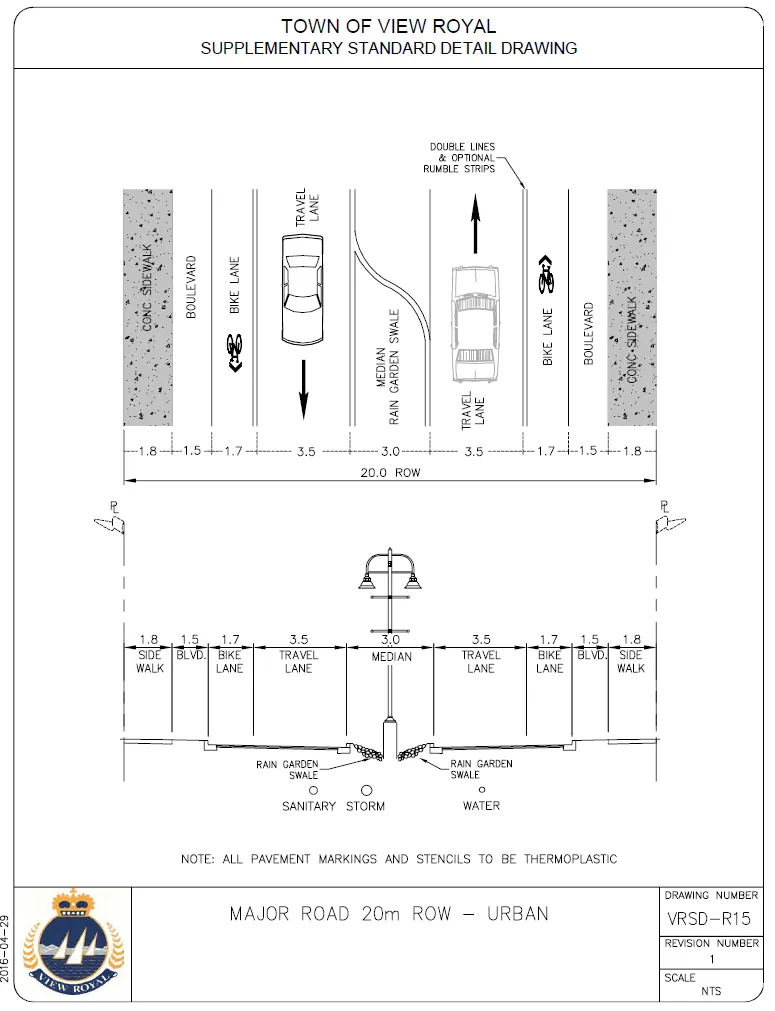
- It would not conform to the Town’s intended cross section for Island Highway.
Subject Property
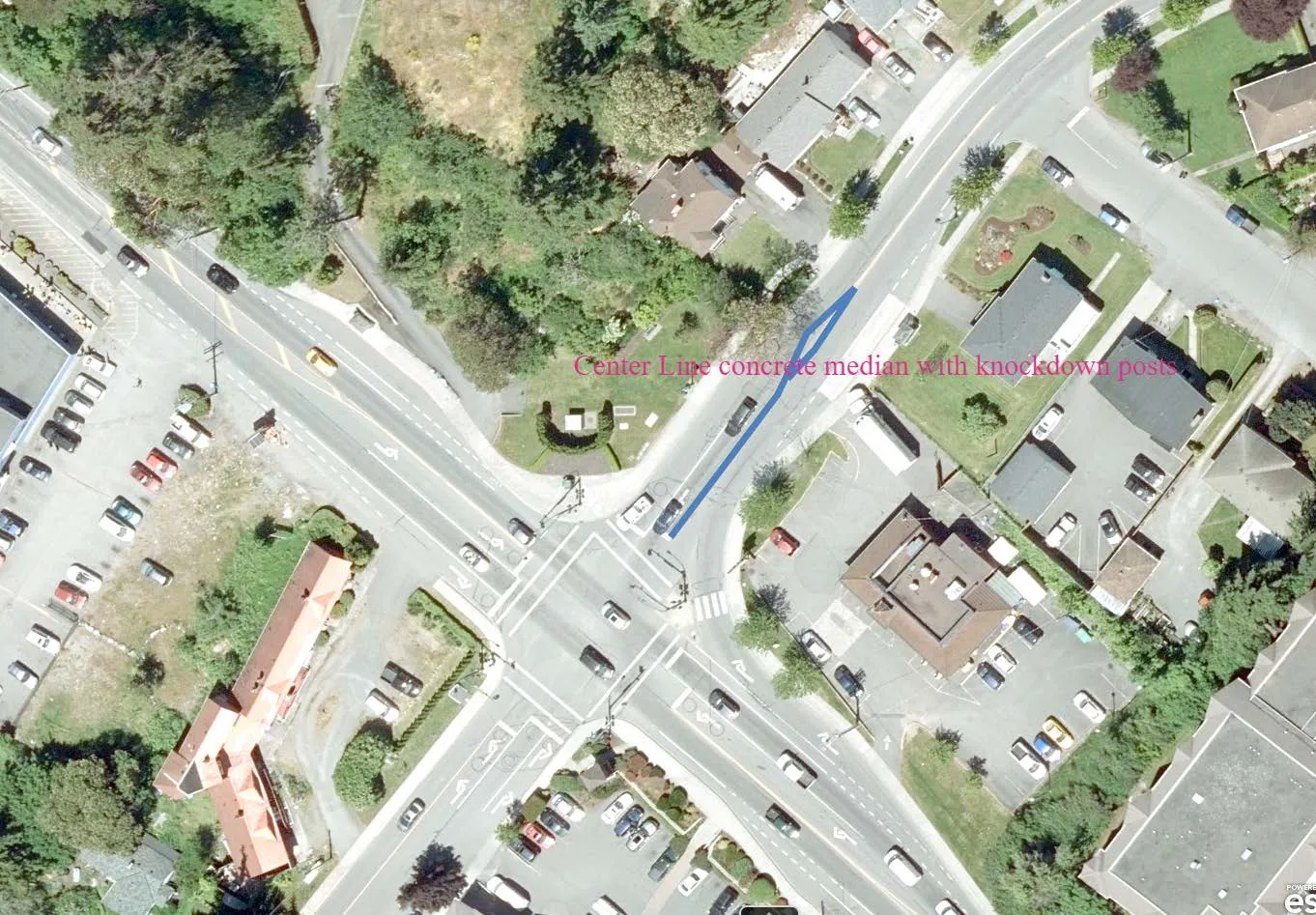
There are no left turns in/out on Island Highway and Helmcken.
- On Helmcken this can be achieved by installing a small concrete median with a few knock down posts for delineation.
- On Island Highway it will be more problematic depending on the frontage design works and how they are achieved especially if the Island Highway work is sequential on the north and south side of island Highway.
Transportation Demand Management - staff recommends:
- Bicycle parking at the ground level instead of underground parking area
- An indoor bike repair station.
Traffic analysis based on Town’s 2017 traffic counts and applicant’s engineer’s count in June 2020. More recent counts may be atypical due to influences from summer, the COVID-19 pandemic, and the construction of the Trans Canada Highway / McKenzie interchange.
There is a discrepancy between Section 5.1 of the Transportation Impact Assessment (Attachment 8) and architect's allocations for commercial parking, but the overall number of spaces meets Zoning Bylaw requirements and will be clarified at the Development Permit stage.
2. Official Community Plan Bylaw Amendment Bylaw No. 1060, 2020
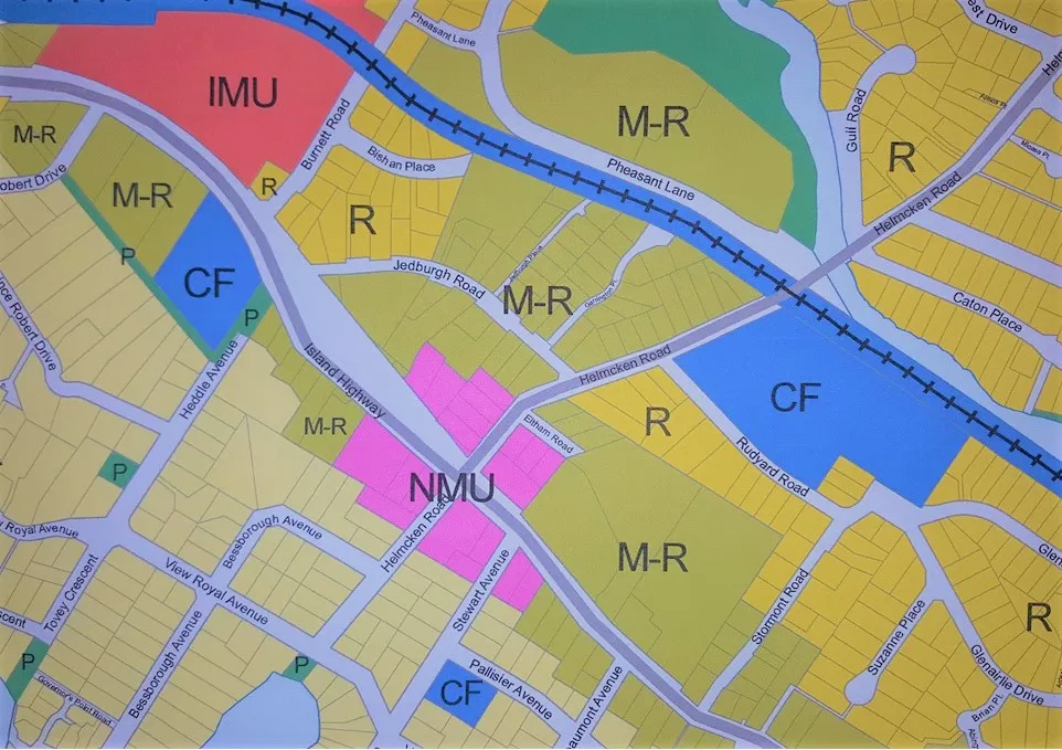
a. New “Neighbourhood Centre” land use designation a. Commercial Residential land uses b. 3.0:1 Floor Space Ratio c. Up to six storeys d. Properties in this land use designation to be subject to Neighbourhood Mixed Use Development Permit Area requirements b. Assign the “Neighbourhood Centre” land use designation to the subject property
Official Community Plan land use designations

3. Zoning Bylaw No. 900, 2014, Amendment Bylaw No. Bylaw No. 1061, 2020
a. New CD-26: Island Highway/Helmcken Comprehensive Development zone b. Rezone subject property to CD-26 Zone
*Recommend a covenant to secure community amenity contribution of $3,500 per residential unit prior to issuance of a building permit *
CD-26: Island Highway / Helmcken Comprehensive Development
Principal Uses
- Mixed Commercial and Residential Use
Accessory Uses
- Home Occupation
| CD-26: Island Highway / Helmcken Comprehensive Development | |
|---|---|
| Lot Size | |
| Lot Size, minimum | 1500 m² |
| Lot Density | |
| Floor Space Ratio | 3.0:1 |
| Lot Coverage, maximum | 75% |
| Impermeable Surface Coverage, maximum | 80% |
| Size of Principal Buildings and Other Structures | |
| Building Height, maximum | 21m and 6 storeys |
| Building Width, minimum | 6m |
| Siting of Buildings and Other Structures (Principal and Accessory) | |
| Front Lot Line Setback, minimum except for 5th and 6th storeys | 0m |
| Front Lot Line Setback, minimum for 5th and 6th storeys | 2.0m |
| Rear Lot Line Setback, minimum | 3.0m |
| Side Lot Line Setback | 3.0m |
| Flanking Lot Line Setback, minimum except for 5th and 6th storeys | 0m |
| Flanking Lot Line Setback, minimum for 5th and 6th storeys | 2.0m |
RECOMMENDATION
THAT, coincident with final reading of Zoning Bylaw No. 900, 2014, Amendment Bylaw No. Bylaw No. 1061, 2020, a covenant be registered on the lands at 298 Island Highway for the provision of a community amenity contribution of $3,500 per residential unit prior to issuance of a building permit.
4. DEVELOPMENT CONCEPT
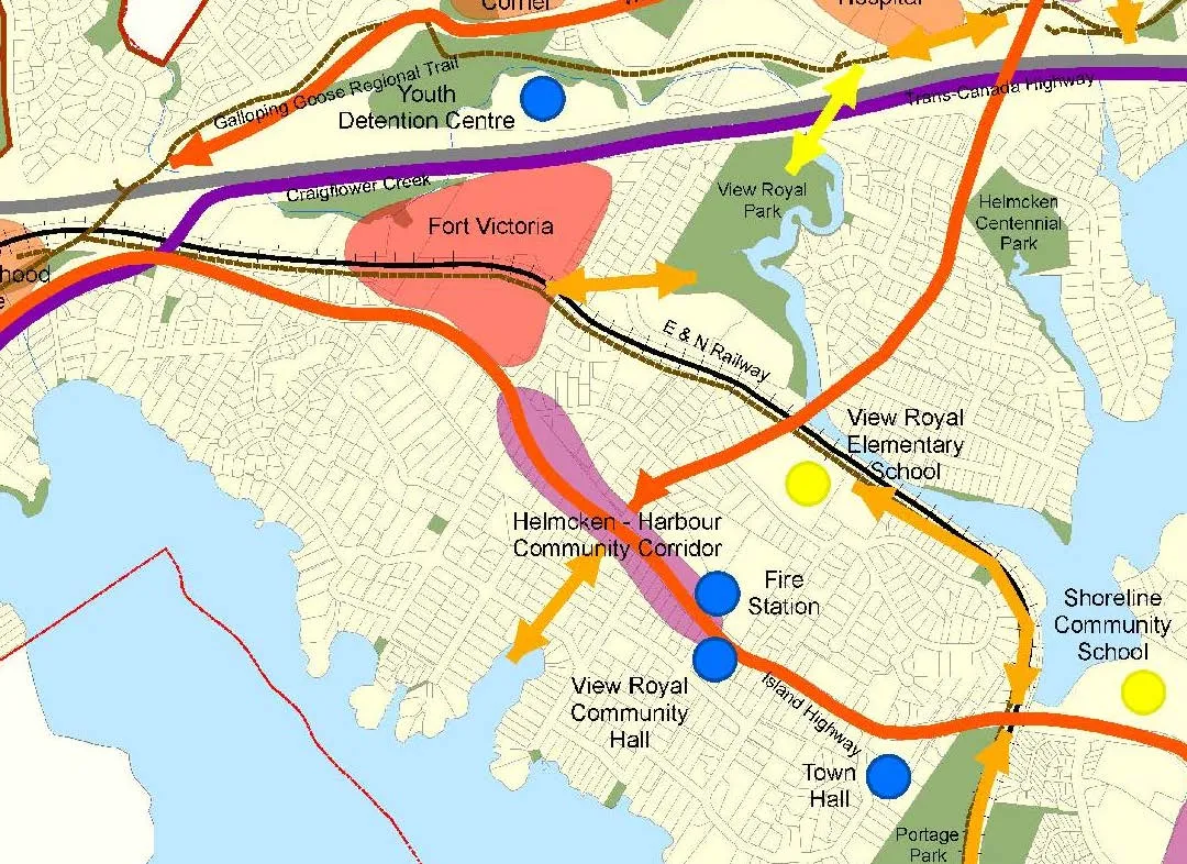
Figure 2. Island Highway frontage (proposed boulevard trees not shown)
Figure 3. Helmcken Road frontage (proposed boulevard trees not shown)
Development Concept (development permit stage)
- Six-storey building with the upper two storeys set back
- Ground floor: 560m² commercial use
- Upper floors: 54 apartment units
- Two levels of underground parking.
- 16 one-bedroom units
- 37 two-bedroom units
- 1 three-bedroom unit
| Category | Specification |
|---|---|
| Lot Size | 1853m² |
| Floor Area | 5559 m² |
| Floor Space Ratio | 3.0:1 |
| Units/Hectare | 292 |
| Building Height | 20.3m |
| Storeys | 6 |
| Site Coverage | 75% |
| Units Proposed | 54 |
| Vehicle Parking | 103 (103 required) |
| Secure Bike Parking | 62 (56 required) |
Perspectives from Island Highway
Plaza rendering
Figure 2. Island Highway frontage (proposed boulevard trees not shown)
Figure 3. Helmcken Road frontage (proposed boulevard trees not shown)
Subject property
Official Community Plan Context (3 of 5)
Within the Helmcken-Harbour Community Corridor:
- Mixed-use intensification and public space improvements concentrated at intersection
- Applicant’s concept for a neighbourhood grocery/deli is consistent with the policy that commercial uses should be neighbourhood-serving and limited to properties located near the Helmcken Intersection.
- Plaza supports pedestrian safety and connections across the two roads
- Provides a high-quality built environment and would become a landmark for this neighbourhood centre.
- Strong and safe connections would be provided to surrounding residential areas, the waterfront, Helmcken Road, View Royal Elementary School and the planned Town Centre.
- Higher residential densities fronting the Island Highway
- Would complement and not compete with the future Town Centre and would not inhibit eventual development of the Town Centre desired for the Fort Victoria site.
Official Community Plan Context (4 of 5)
- Consideration should be made on whether the mixed-use intensity would be appropriate for the corridor’s lots sizes and adjacent residential areas
| Development | Address | Units | Lot Area | Units per hectare |
|---|---|---|---|---|
| Current proposal | 298 Island Highway | 54 | 0.1853 ha | 291.4 |
| Lions Cove | 288/290 Island Highway | 66 | 0.8275 ha | 80.0 |
| Maia London | 280 Island Highway | 37 | 0.1677 ha | 220.6 |
| <DP approved, not built> | 242-244 Island Highway | 37 | 0.1860 Ha | 198.9 |
Official Community Plan Context (5 of 5)
OCP Consultation
- The application was referred to the relevant agencies as part of the application review process with no major concerns noted.
- If the application moves forward to a public hearing, the agencies be formally notified of the amendment bylaw in conjunction with the public hearing process.
Consultation and Notification by applicant
- April 2020 – door knocking campaign for residences within three blocks
- May 2020 - open house for 288/290 Island Highway (Lions Cove).
- October 2020 – over 500 flyers distributed to properties within the 400m public hearing notification radius, with website/email address setup to receive comments
Document Images
(1)