Presentation - Rezoning Application No. 2020/02 - 9 Erskine Lane
A staff presentation outlining the rezoning proposal to change the status of 9 Erskine Lane from Rural Residential (A-1) to Mixed Residential (RM-3) for a multi-family rental development.
REZONING APPLICATION 2020/02
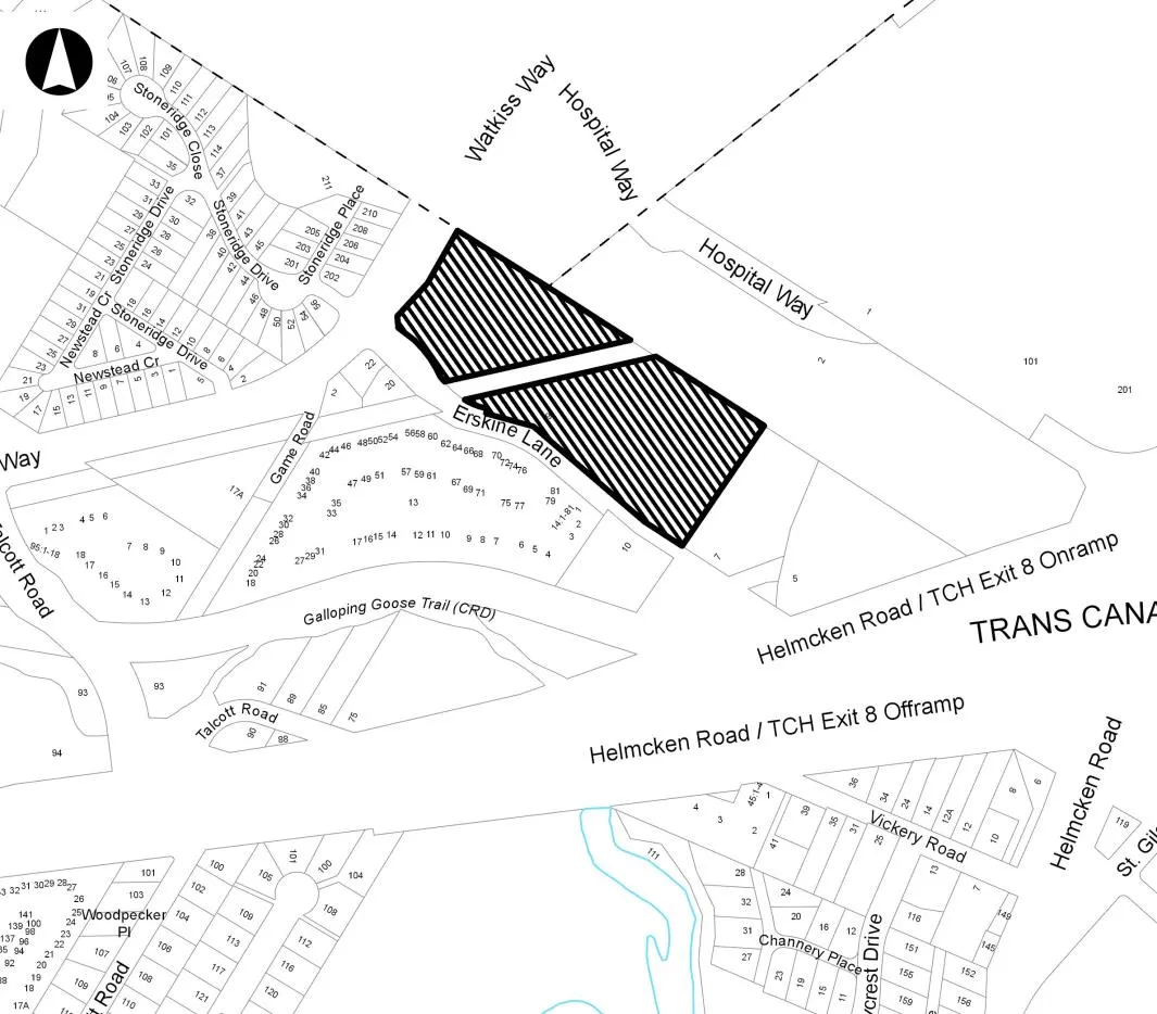
9 Erskine Lane
Rezoning application to rezone the subject property from A-1: Rural Residential to RM-3 (Mixed Residential) for multifamily use.
Follow up to March 10, 2020 Committee of the Whole meeting
| Item | |
|---|---|
| Development Concept: Trees, underground parking, renderings from Watkiss Way and Erskine Lane, reducing automobile demand | To be discussed in presentation |
| Transportation Impact Assessment – more information on • pedestrian safety • how the Erskine/Watkiss intersection would operate best, post-development - signalization and roundabout • impact to the levels of service |
To be discussed in presentation |
| Clarification of road dedication requirements | 3m road dedication to be secured in a covenant |
| Determination if the ditch along the Watkiss Way frontage is a watercourse | R.P.Bio confirmed ditch not subject to Riparian Areas Regulation |
| Community amenity contributions | Policy rate of $3500/unit to secured in a covenant |
| Sustainability checklist | Provided (report Attachment 10) |
OUTLINE
- Development Concept
- OCP Policy
- Development Impacts a. Traffic b. Servicing c. Environment
- Public consultation
- Next Steps
1. Development Concept
- Rezoning applications address zoning issues of land use, density, and standards for lot coverage, percentage of impervious surface, the height and siting of buildings in general.
- Development concept is to illustrate applicant’s intent for form and character of design that would be considered in a development permit application following rezoning.
Proposal
- 372 rental apartment units
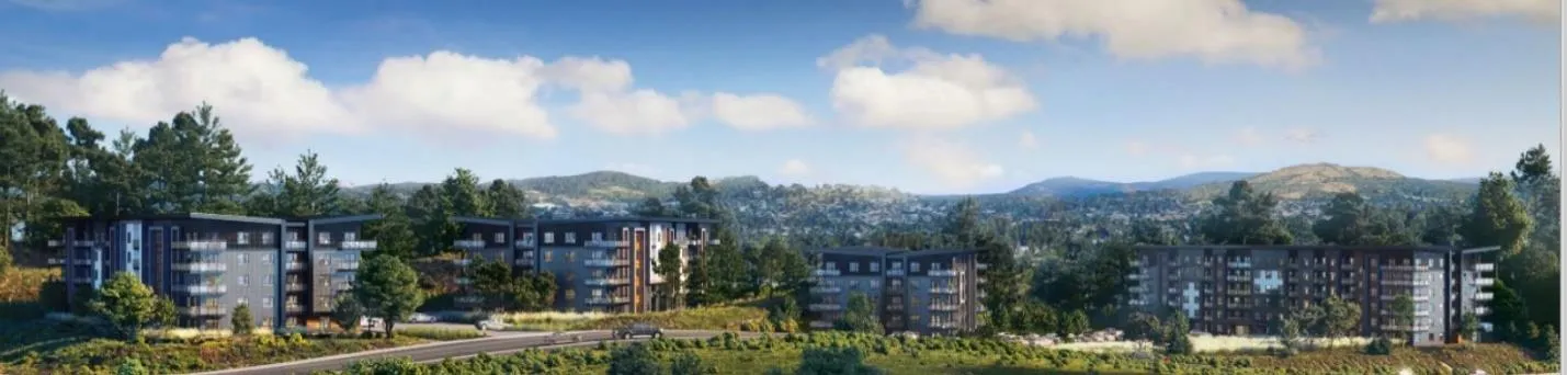
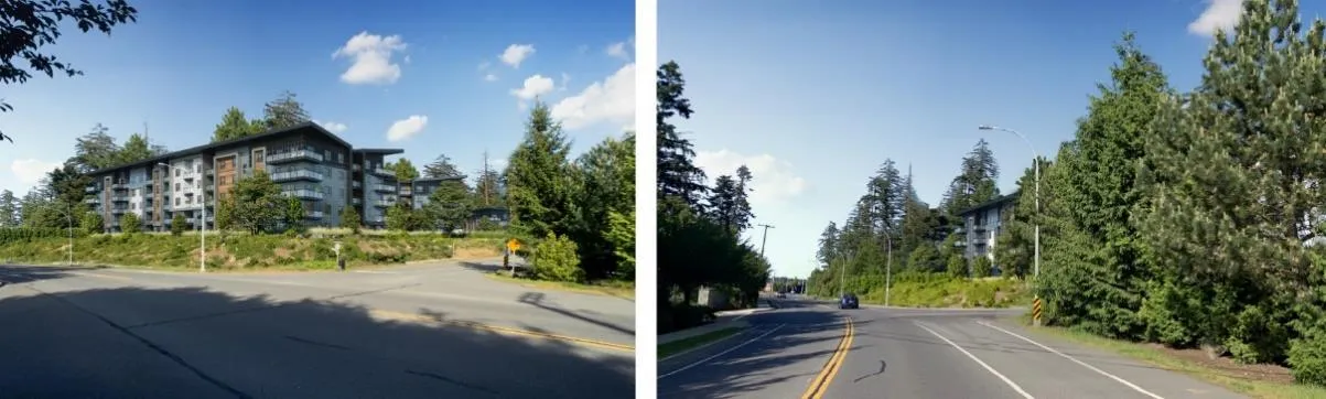
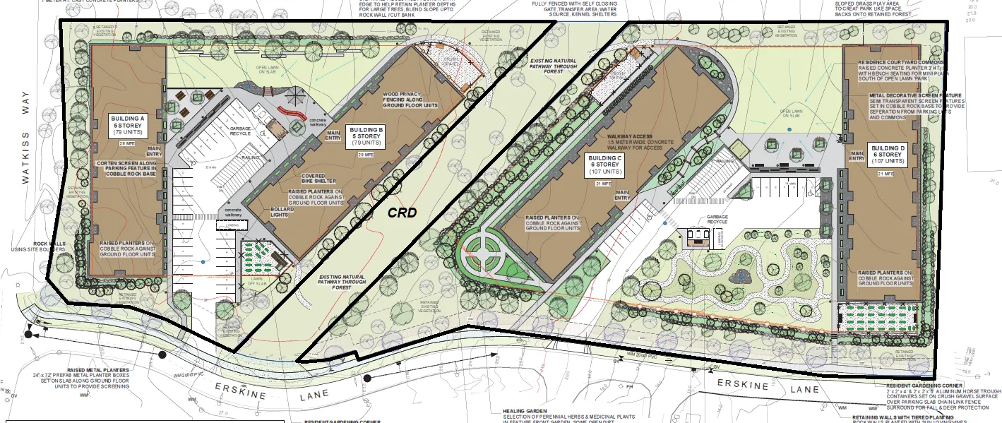
- Two five storey buildings at the high end of the site and two six storey buildings at the low end, with underground parking to be fully concealed.
1. Development Concept (continued)
| Lot A (north) | Lot B (south) | Total | |
|---|---|---|---|
| Buildings | 2 | 2 | 4 |
| Storeys | 5 | 6 | |
| Studio units | 8 | 10 | 18 |
| One-bedroom units | 70 | 108 | 178 |
| Two-bedroom units | 60 | 72 | 132 |
| Three-bedroom units | 20 | 24 | 44 |
| Total | 158 | 214 | 372 |
Applicant has agreed to a covenant for:
- Housing agreement to ensure rental tenure for 20 years (BC Housing covenant is for ten years)
- Provision of 44 three-bedroom units
Erskine Lane
Watkiss Way
On site features
- raised planter boxes for resident container gardening
- outdoor tables and seating
- fenced dog runs with water and shelters
- plaza and lawn type passive open spaces
- a herb/healing garden
- ‘discovery nature area’ with walking paths featuring native plant species salvaged from site clearing.
Tree management
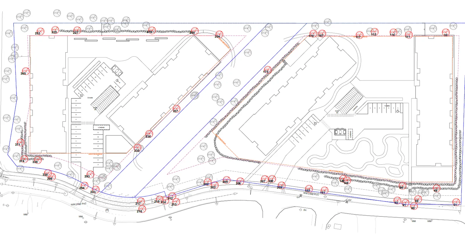
a. Trees to be retained are within setback areas as buildings and underground parking occupy most of the permitted building envelope (Att 3. p23) b. Approximately 30 trees would be retained along the Erskine Lane frontage. c. Approximately six trees would be retained along the Watkiss Way frontage plus nine trees in the boulevard. d. Plans note approximately 129 trees on the perimeter (shown in red in Att 3. p2.3 and Att. 5 p2) would be removed due to proximity to foundations of buildings and underground parking, or are within locations in the areas to be dedicated for road and sidewalk on Erskine Lane
2. OCP POLICY
The OCP land use designation is ‘Mixed Residential’, which supports:
- Small lot detached houses
- Townhouses up to three storeys and a maximum 1.25:1 floor space ratio
- Apartment buildings up to four storeys and a maximum floor space ratio of 1.5:1
| Policy LU1.5 | Intensive Mixed Use | RM-3 Zone | Development Concept |
|---|---|---|---|
| Floor Space Ratio | 1.5:1 | 1.5:1 | Lot A: 1.44:1 Lot B: 1.27 Total: 1.35 |
| Storeys | 4 | (13.5m building height) | 5-6* (app. 15.5 - 18.2m)* |
*Building height to be considered in a development permit application
2. OCP Policy (continued)
RM-3: Mixed Residential Zone
| Lot Size | |
| Lot Size, minimum | 1500m² |
| Lot Width, minimum | 40m |
| Lot Density | |
| Floor Space Ratio, Base Density | 1.5 |
| Floor Space Ratio with provision of 80% underground parking | Base Density + 0.1 |
| Lot Coverage, maximum | 60% |
| Impermeable Surface Coverage, maximum | 80% |
| Building Size | |
| Building Height, maximum | 13.5 |
| Building Width, minimum | 6m |
2. OCP Policy (continued)
The proposed zoning would comply with OCP policies (Report attachment 7) as follows:
- Higher density at a neighbourhood centre in a location that will promote walkability, cycling and transit use by bring people closer to transport, services and employment.
- Increases workforce housing to support the Hospital and local businesses the neighbourhood centre
- Increasing rental housing supply will assist with housing affordability in the region
- Community amenities contributions can be used to help to improve local conditions and encourage non-automobile transportation.
2a. Potential Impacts - Transportation
Transportation impact assessment:
- The developer will provide a sidewalk along the Erskine Lane and Watkiss Way development frontages.
- The developer to implement TDM strategies (car share vehicles (2) and electric bicycle share (2)) to reduce vehicle traffic and encourage active modes.*
- The developer to provide a left turn lane on Watkiss Way at Erskine Lane.
- The developer to contribute towards the signalization of Erskine Lane / Watkiss Way.
- The developer to provide funds for upgrading the Hospital trail to at least a 3m gravel pathway.
Staff accepts the recommendations of the traffic impact assessment as requirements for the development save for item 5 (on the CRD property and leads to and over a privately held property)
*Note: Car/bike share is an on-site feature to be secured in a covenant
2a. Traffic Impacts
- A number of improvements to the Erskine/Watkiss intersection desired by the neighbourhood are not technical requirements to address impacts of the development.
- Regional traffic is expected to increase on Watkiss Way in the long term and the TIA included a review of the potential for improvements at the Erskine/Watkiss intersection. Key conclusions are: a. Signal vs. roundabout have similar benefits to levels of service b. “The roundabout has the least impact to traffic on Watkiss Road and provides the same or slightly better operations than a signal. Both the signal and the roundabout have the opportunity to provide crosswalks on all four legs. While a signal will provide for controlled crosswalks (with pedestrian signals), pedestrians at roundabout crosswalks only have to deal with one direction of traffic at a time and have a refuge area to wait in the middle of the roadway.”
- One of the potential funding sources could be the community amenity contributions from this and the recent rezoning at 7 Erskine Lane.
2b. Servicing Impacts
- Requirements include provision of sidewalks along the site frontages, no net increase in post-development site runoff, and that storm water entering the Town’s drainage system will meet the requirements of Storm Water Regulation Bylaw.
- Confirmed adequate sanitary sewer capacity for Town’s allocation of discharge to the regional sewer system.
- Road dedication of approximately 3m along the Erskine Lane frontage where the width of the road right-of-way is substandard will be secured in a covenant.
2c. Environmental Impacts
- Not within Sensitive Terrestrial Systems Development Permit Area
- Predominantly Douglas fir forest with some woodlands and Garry oak ecosystem on the north section. The site is fragmented from other forest areas and contains invasive plant species at varying densities.
- Ditch along Watkiss Way is not a watercourse
3. Community Amenity Contribution
- OCP Policy HS1.4 “Housing Amenity Contributions” states that any proposed multi-unit residential development requiring a rezoning should provide a “housing amenity” contribution to the Town, which could be directed to the Regional Housing Trust Fund.
- Agreement to provide Community Amenity Contribution Policy target of $3500 per unit x 372 = $1,302,000. These funds can be used at Council’s discretion.
- This contribution will be secured in a covenant and provided at the building permit stage
4. Public Consultation by applicant
- Door to door canvassing prior to application submission
- February 2020 open house
- March 4, 2020 open house
5. Next Steps
Through the review process the applicant has agreed to a covenant to secure the following prior to issuance of a building permit:
- a community amenity contribution of $3,500 per residential unit;
- road dedication along the Erskine Lane frontage;
- provision of a car share and bike share;
- a housing agreement to secure rental tenure for twenty years; and
- commitment to provide at least 44 three-bedroom units.
This is the second round of review for this application. If additional development approval information is considered necessary, it would be optimal to clarify at this time.
RECOMMENDATION:
THAT the June 11, 2020 report from the Senior Planner titled “Rezoning Application 2020/02 – 9 Erskine Lane” be received for information.