BCLS Survey - Strata Lot 4, Section 8, Esquimalt District
Professional legal survey plan showing precise lot boundaries and the location of proposed structures relative to the natural boundary.
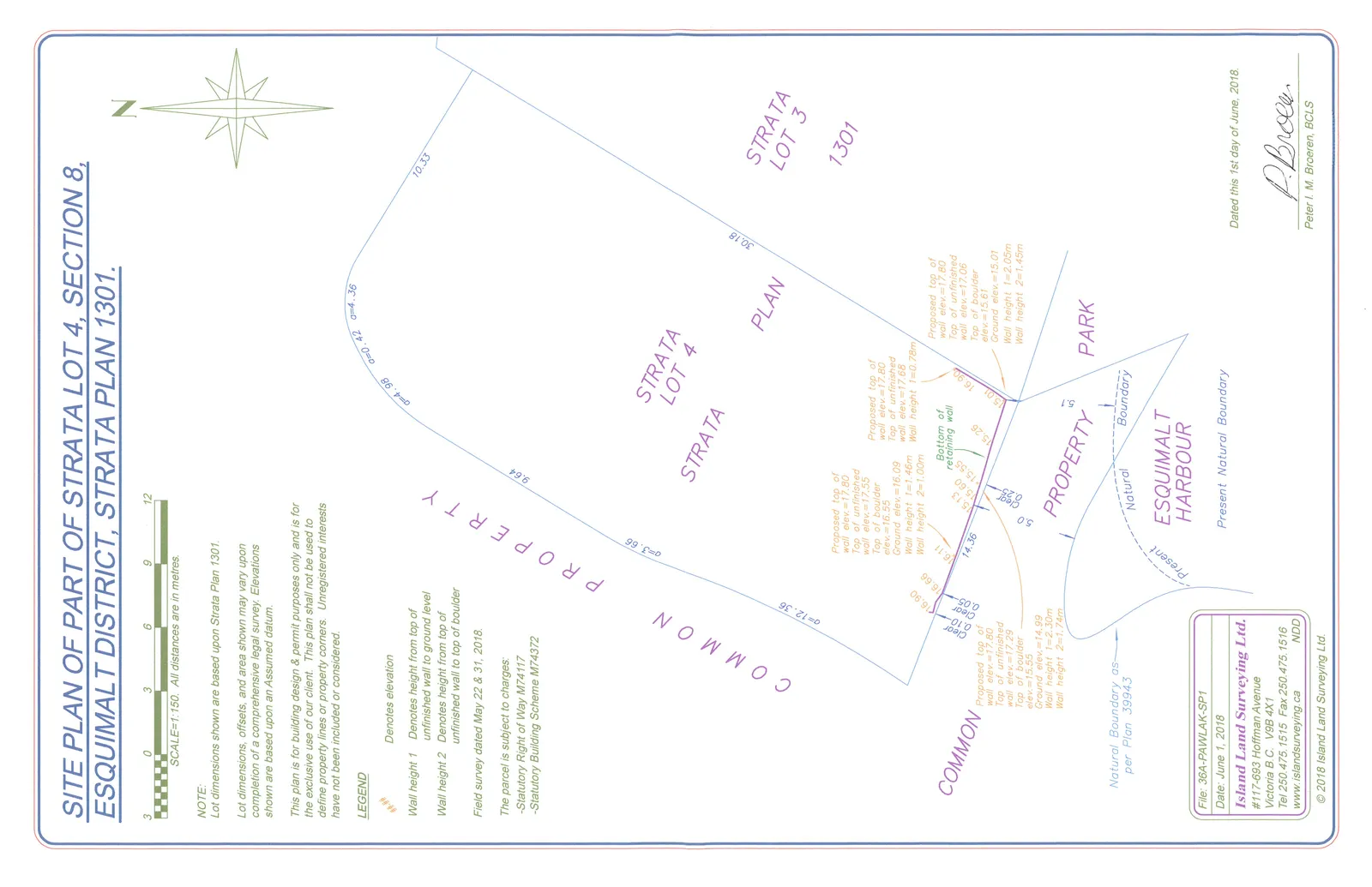
SITE PLAN OF PART OF STRATA LOT 4, SECTION 8, ESQUIMALT DISTRICT, STRATA PLAN 1301.
SCALE=1:150. All distances are in metres.
NOTE:
Lot dimensions shown are based upon Strata Plan 1301.
Lot dimensions, offsets, and area shown may vary upon completion of a comprehensive legal survey. Elevations shown are based upon an Assumed datum.
This plan is for building design & permit purposes only and is for the exclusive use of our client. This plan shall not be used to define property lines or property corners. Unregistered interests have not been included or considered.
LEGEND
- ##.## Denotes elevation
- Wall height 1: Denotes height from top of unfinished wall to ground level
- Wall height 2: Denotes height from top of unfinished wall to top of boulder
Field survey dated May 22 & 31, 2018.
CHARGES
The parcel is subject to charges:
- Statutory Right of Way M74117
- Statutory Building Scheme M74372
Elevation and Wall Height Data
Point 1 (Common Property Area, Bottom Left):
- Proposed top of wall elev. = 17.80
- Top of unfinished wall elev. = 17.29
- Top of boulder elev. = 15.55
- Ground elev. = 14.99
- Wall height 1 = 2.30m
- Wall height 2 = 1.74m
Point 2 (Near Retaining Wall, Center Left):
- Proposed top of wall elev. = 17.80
- Top of unfinished wall elev. = 17.55
- Top of boulder elev. = 16.55
- Ground elev. = 16.09
- Wall height 1 = 1.46m
- Wall height 2 = 1.00m
Point 3 (Near Retaining Wall, Center Right):
- Proposed top of wall elev. = 17.80
- Top of unfinished wall elev. = 17.65
- Wall elev. = 17.65
- Wall height 1 = 0.78m
Point 4 (Near Retaining Wall, Bottom Right):
- Proposed top of wall elev. = 17.80
- Top of unfinished wall elev. = 17.06
- Top of boulder elev. = 15.61
- Ground elev. = 15.01
- Wall height 1 = 2.05m
- Wall height 2 = 1.45m
Additional Plan Labels
- STRATA LOT 4
- STRATA PLAN 1301
- STRATA LOT 3
- COMMON PROPERTY
- PARK
- ESQUIMALT HARBOUR
- Natural Boundary per Plan 39943
- Present Natural Boundary
- Bottom of retaining wall
Document Information
- File: 36A-PAWLAK-SP1
- Date: June 1, 2018
- Company: Island Land Surveying Ltd.
- Address: #117-693 Hoffman Avenue, Victoria B.C. V9B 4X1
- Tel: 250.475.1515
- Fax: 250.475.1516
- Website: www.islandsurveying.ca
- Dated: 1st day of June, 2018.
- Surveyor: Peter I. M. Broeren, BCLS
- © 2018 Island Land Surveying Ltd.