Planning & Development Report: ENVIRONMENTAL DEVELOPMENT PERMIT 2017/07 - 2215 Meadow Vale Drive
Staff report regarding a development permit and variance for a deck at 2215 Meadow Vale Drive near a streamside protection area.
TOWN OF VIEW ROYAL
Planning & Development Report
TO: Mayor and Council FROM: J. Chow, Senior Planner DATE: January 18, 2018 MEETING DATE: January 23, 2017 FILE NO.: 3060-20-2017/07
ENVIRONMENTAL DEVELOPMENT PERMIT 2017/07 - 2215 Meadow Vale Drive
RECOMMENDATION
THAT Development Permit 2017/07 be approved;
AND THAT Development Permit 2017/07 include the following the conditions:
- Native vegetation is to be planted within the portion of the property that is within the Streamside Protection and Enhancement Area.
- A landscape security deposit is to be submitted prior to building permit issuance for the provision and installation of native vegetation.
AND FURTHER THAT Development Permit 2017/07 include the following variance: a. Variance to the minimum required siting of a primary building from a rear lot line from 6.0m to 5.1m to permit the siting of a deck.
CHIEF ADMINISTRATIVE OFFICER’S COMMENTS
I concur with the recommendation.
DIRECTOR OF DEVELOPMENT SERVICES’ COMMENTS
I concur with the recommendation.
PURPOSE OF REPORT:
To consider a development permit application for the construction of a deck partly within the Natural Watercourse and Shoreline Environmental Development Permit Area. A variance for siting of the deck from the rear lot line is also requested.
BACKGROUND:
The 652m² residential property backs onto Thetis Lake Regional Park near Craigflower Creek. The detached residential dwelling on the property was built in the late 1990s. A covenant registered at the time of subdivision to restrict the placement of structures in the rear yard is in the process of being discharged because the Provincial Riparian Areas Regulation and Natural Watercourse and Shoreline Areas Development Permit Area are now in place.
PROPOSAL:
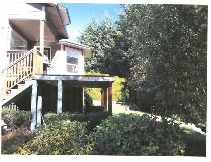
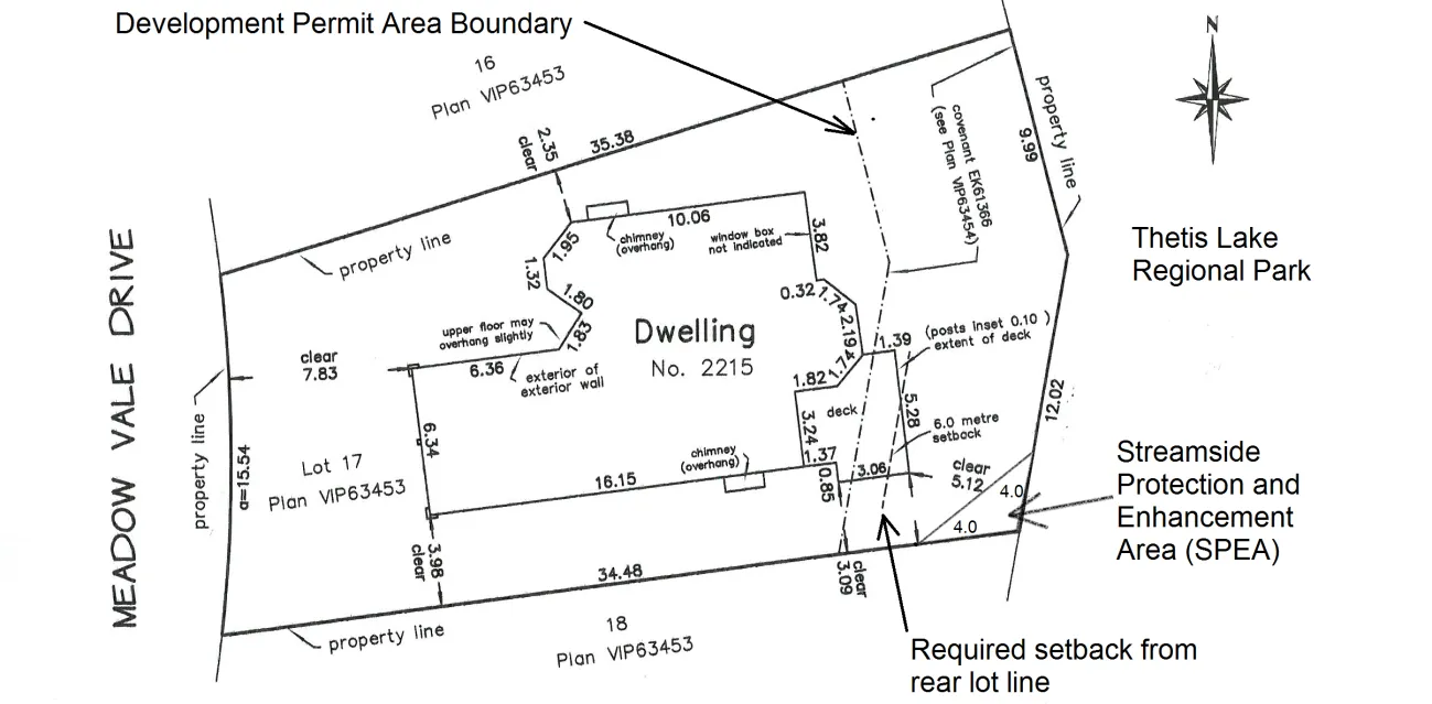
The proposal is to complete the construction of a deck (Figure 1) at the rear of the dwelling that would be partially within the Natural Watercourse and Shoreline Areas Development Permit Area as shown in Figure 2.
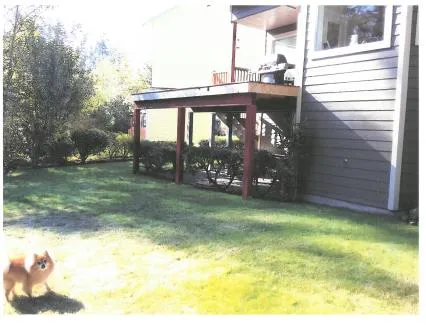
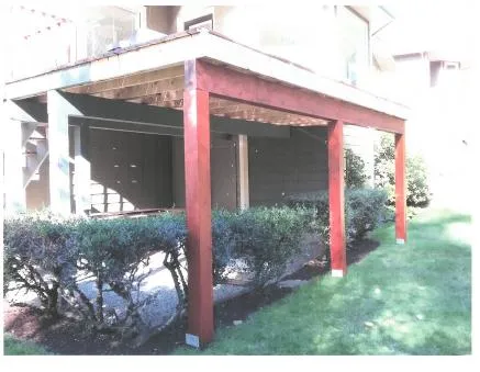
The R-1B Detached Residential (Medium Lot) zone requires a minimum setback of 6.0m. A variance is requested to site a 0.75 m² corner of the deck 5.1 m from the rear lot line as shown in Figure 2.
The applicant has provided the following information in support of the proposal:
- A letter with rationale for request (Attachment 2)
- Letters and petitions of support (Attachments 3-6)
- Biologists report prepared by a Qualified Environmental Professional (Attachment 7)
- Planting Plan (Attachment 8)
- Site Survey (Attachment 9)
ISSUES AND ANALYSIS:
The key issues are:
- How does the proposal address the development permit area guidelines?
- Is the request variance supportable?
1. Development Permit Area Guidelines
The relevant guidelines of the Natural Watercourse and Shoreline Areas Development Permit Area are as follows:
General iv. Restoration of riparian and shoreline vegetation and habitat, including removal of invasive species, is encouraged for all properties within this Development Permit Area. Development should result in a net increase in native vegetation in almost all circumstances including trees, shrubs and grasses.
The development permit area covers land within 30m from the natural boundary of a watercourse and includes nearly all of the of the rear yard as shown in Figure 2. Within the development permit area, the Streamside Protection and Enhancement Area (SPEA) is the critical area where development should not occur because it part of sensitive riparian habitat. The biologists report (Attachment 7) has identified a 9m² area in the south east corner of the subject property as within the SPEA for Craigflower Creek to (Figure 2). .
The proposal can be supported because: a. The deck would be located outside of the SPEA and would not affect it. b. The portion of the property that is within the SPEA would be restored with native vegetation such as Sword Fern and Fuchsia-Flavoured Gooseberry that would be appropriate to the location as shown in Attachment 8.
2. Requested Variance
The request to vary the siting of the deck from 6.0m to 5.1m from the rear lot line can be supported for the following reasons: a. The requested variance is for only one corner of the deck b. The requested variance is minor and is not expected to have much impact on adjacent residential properties or the path in the park behind the subject property.
RECOMMENDATION:
THAT Development Permit 2017/07 be approved;
AND THAT Development Permit 2017/07 include the following the conditions:
- Native vegetation is to be planted within the portion of the property that is within the Streamside Protection and Enhancement Area.
- A landscape security deposit is to be submitted prior to building permit issuance for the provision and installation of native vegetation.
AND FURTHER THAT Development Permit 2017/07 include the following variance: b. Variance to the minimum required siting of a primary building from a rear lot line form 6.0m to 5.1m to permit the siting of a deck.
SUBMITTED BY: Jeff Chow, MCIP RPP, Senior Planner REVIEWED BY: Lindsay Chase, MCIP RPP, Director of Development Services
ATTACHMENTS:
- Property Location Map
- Letter from Applicant – November 15, 2017 (3 pages)
- Letter from Cecelia and Tim Walzak – October 4, 2017
- Letter from Barry and Suzana Kalyn – October 4, 2017
- Letter from Susan de Stephanis – October 25, 2017
- Petition signed by neighbourhood residents
- Riparian Areas Assessment Report – Enkon Environmental, June 16, 2017 (27 pages)
- Planting Plan
- BC Land Surveyors Building Location Certificate, Glen Mitchell Surveying - August 24, 2017
Document Images
(3)