Schedule 4 - Current DP 2016/10 Drawings
Reference architectural and design drawings from the previously approved development permit in 2016.
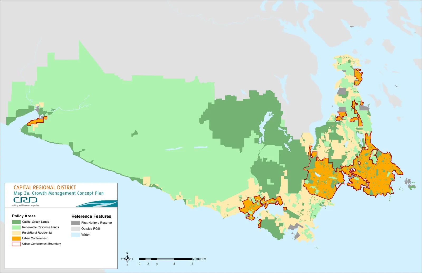
MAP 3(A): GROWTH MANAGEMENT CONCEPT PLAN
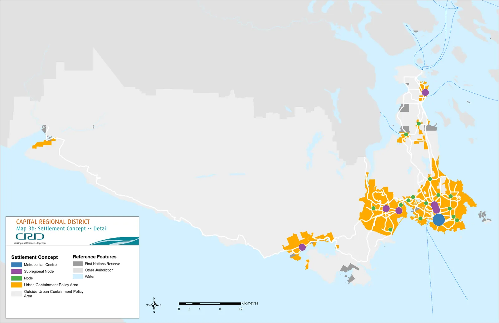
MAP 3(B): SETTLEMENT CONCEPT – DETAIL
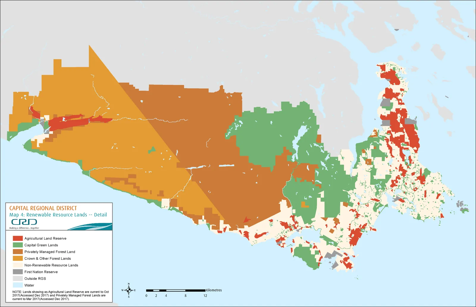
MAP 4: RENEWABLE RESOURCE LANDS - DETAIL
MAP 5: MUNICIPAL BOUNDARY ADJUSTMENT - DETAIL
Policies
- Provide for land uses consistent with the Growth Management Concept Plan depicted on Map 3(a) and adopt policies to implement the Growth Management Concept Plan consistent with the land use policy designations described in Objective 1.1.
- Adopt policies regarding the protection, buffering and long term maintenance of the
Growth PolicyUrban Containment Policy Area Boundary. - Permit amendment to the
Growth PolicyUrban Containment Policy Area designation generally, only as an outcome of a comprehensive 5–year review of the Regional Growth Strategy, recognizing that municipal councils and the Capital Regional District Board are free to initiate at any time amendments to official community plans and the regional growth strategy they deem necessary, through statutory processes established in the Local Government Act. - Maintain Victoria as the primary regional employment, business and cultural centre.
- Enhance or develop major employment and population centres in areas that meet criteria, as set out in Objective 3.1, for complete communities. 5.6. Encourage planned growth in the nodes shown on Map 3(b) and described in Objective 1.1, and plan for transportation infrastructure to align. It is recognized that the location of the nodes is conceptual and that municipal conformance may vary. Local planning decisions relating to nodes will not require a Regional Growth Strategy amendment.
1.2 Protect the Integrity of Rural Communities
Keeping urban settlement compact will help protect the character and quality of rural communities, ensure that they remain strongly rooted in the agricultural and resource land base, and allow the rural countryside and natural landscape to remain a durable fact of life in the Capital Region. The protection of rural communities starts with clearly defining and distinguishing between urban and rural areas. The Regional Growth Strategy does this by designating for long term protection as Capital Green Lands and Renewable Resource Lands those natural assets including parks, ecological reserves, forests, farmland and watersheds that make up the region’s green infrastructure and contribute to the regional economy. The designation of an Growth Policy Urban Containment Policy Area reinforces the protection of Capital Green Lands, Renewable Resource Lands and Rural/Rural Residential Policy Areas and has the further benefit of supporting the long–term effort to keep urban settlement compact.
Rural and rural–residential communities offer a choice of rural lifestyles and outdoor recreation opportunities that complement the surrounding working landscapes and preserve ecological diversity. New development in the Rural/Rural Residential Policy Area is not intended to exceed 5% of the region’s new dwelling units. Policy 1.1 protects rural communities by requiring that local municipalities and the Juan de Fuca Electoral Area provide for land uses consistent with the Growth Management Concept Plan and adopt policies that would prevent lands designated as Rural/Rural Residential from becoming future urban areas. Strengthening the character and quality of rural communities can be achieved by planning for development in accordance with the principles set out below.
Principles
I. Maintain working landscapes including agriculture, forestry and outdoor recreation activities that contribute to the region’s economy; II. Avoid the creation of future urban areas through development patterns that complement rural form, density and character; III. Minimize impacts to the natural environment and surrounding working landscapes; and IV. Accommodate a slow to moderate rate of growth, contributing to no more than 5% of the region’s new residential units.
Policies
- Plan for development in the Rural/Rural Residential Policy Area depicted on Map 3(a) in a manner that is consistent with the principles set out in Objective 1.2.
2. Environment and Infrastructure
2.1 Protect, Conserve and Manage Ecosystem Health
The Capital Region has a rich inheritance of natural lands and waters of great beauty and biophysical diversity. Residents of the Capital Region enjoy a healthy environment where environmental quality is improved and the inheritance of renewable and non-renewable natural resources is carefully stewarded. Many of the region’s terrestrial, fresh water and marine environments – its green and blue spaces – are of provincial, national and international significance.² The system of green and blue spaces that make up the region’s natural environment spans a diverse range of ecosystems and land uses and requires integrated, collaborative and co-operative management of land and water resources. The Regional Growth Strategy aims to protect the landscape character, ecological heritage and biodiversity of the Capital Region by protecting, conserving and managing lands according to the principles set out below.
Principles
I. Waste discharges of all types should not exceed the assimilative capacity of the natural environment (including land, air and water); II. Depletion rates for natural resources should not exceed the regenerative capacity of the ecosystems that produce them; III. Consumption of scarce renewable and non–renewable resources should be minimized through conservation, efficiency and application of technology and reduce, reuse and recycle practices; IV. Benefits derived from healthy ecosystems should be recognized and integrated into land use management and service delivery decisions; and, V. Decision–making should give first priority to options that maintain ecosystem and population health and support the ongoing ability of natural systems to sustain life.
Parkland acquisition protects lands for conservation and recreation by establishing a connected system of natural areas. Central to this system is the protection of a sea to sea green/blue belt running from Saanich Inlet south to Juan de Fuca Strait, and the development of an integrated system of parks and trails linking urban areas to rural green space areas. By applying these principles, it will be possible to improve human health, reduce negative impacts on the natural environment and mitigate and adapt to the impacts of climate change.
² The Regional Green/Blue Spaces Strategy was a foundational document for the development of the 2003 Regional Growth Strategy. The Strategy has been superseded by subsequent planning initiatives such as the Regional Parks Strategic Plan, the Integrated Watershed Management Program Plan, the Regional Parks Land Acquisition Strategy and park management plans for the Sooke Hills Wilderness and Sea to Sea Regional Parks.
Policies
- Ensure the long–term protection of Capital Green Lands depicted on Map 3(a). Recognizing the varied ecological and recreational contexts of the Capital Green Lands,
Thisthis could include municipal policies and CRD electoral area policies for buffering and land use transition between Capital Green Lands and adjacent settled areas (i.e., lands within the Rural/Rural Residential Land Use Policy Area as well as theGrowth PolicyUrban Containment Policy Area), as well as policies aimed at enhancing, restoring or naturalizing Capital Green Lands. Notwithstanding the above, local governments will retain the ability to dispose of or rezone parklands. 1.2. Municipalities will identify regionally significant parks through their Regional Context Statements. The Juan de Fuca Electoral Area will identify regionally significant parks in Official Community Plans. 2.3. Prioritize community and regional park land acquisition, public and private land stewardship programs and regional trail network construction that contributes to completion of the sea to sea green/blue belt running from Saanich Inlet south to Juan de Fuca Strait. 3.4. Identify, protect, enhance and restore healthy ecosystems using tools that may consist of policies, regulations, development permit area guidelines, incentives, initiatives and education and outreach delivered at the local level consistent with the principles set out in Objective 2.1. 4.5. Protect the ecological integrity of watersheds and marine areas through collaborative initiatives consistent with the principles set out in Objective 2.1. 5.6. Manage surface water, drainage and groundwater in non–catchment watersheds throughout the region using an integrated watershed planning approach consistent with the principles set out in Objective 2.1. 6.7. Plan for the long term strategic resource needs in the Capital Region – including food (paying specific attention to local food production), energy, water, and aggregate materials consistent with the principles set out in Objectives 2.1 and 7.1. Plans will consider long term demand, security of supply and potential impacts of factors such as long term climate change, fossil fuel depletion and water reclamation where feasible, and make policy and program recommendations to ensure that future needs are successfully anticipated and met.
2.2 Manage Regional Infrastructure Services Sustainably
Regional infrastructure servicesing infrastructure include drinking water, liquid and solid waste. These services must be efficiently and cost-effectively managed for the long-term in order to accommodate the anticipated population increase.
The Sooke reservoir, managed and operated by the CRD, is the drinking water supply for the Capital Region. The CRD provides treated bulk water to multiple distribution systems around the region. The distribution systems differ by municipality and require ongoing cooperation for the planning and management of the service. Private wells and community water systems supply water to many residents in rural areas.
The Hartland Landfill provides solid waste disposal services for the Capital Region. The CRD sees waste as a commodity and seeks the highest and best use for these resources by applying the 5R hierarchy of Reduce, Reuse, Recycle, Resource Recovery and Residual Management. This includes a focus towards zero waste in our landfill, recycling programs, organics diversion, landfill gas capture and emerging opportunities.
The Saanich Peninsula Wastewater Treatment Plant provides secondary wastewater treatment to residents in the Saanich Peninsula. At the time of writing the Regional Growth Strategy, a planning process is underway to identify wastewater management strategies for the Core Area implementation of the Wastewater Treatment Project is underway. The project will provide tertiary wastewater treatment for residents of the core area municipalities, Colwood and Langford, and the Esquimalt and Songhees Nations. Private septic fields treat liquid waste for residents in rural areas.
Infrastructure services may be impacted not only by an increased demand for the service as the population grows, but also by the form, pattern and location of new development. Servicing new development with limited or low density, which adds fewer new users per unit length of water or sewer pipe than the system average, would generally be more expensive than in denser areas. The costs of operating and maintaining this infrastructure over its lifecycle require consideration beyond the one-time capital investment. Keeping urban settlement compact will help create the densities needed to create efficient infrastructure servicesing infrastructure. It is also necessary to acknowledge and plan for the effects of a changing climate on regional infrastructure.
Managing regional infrastructure services according to the principles below and as outlined in Objective 2.1 will help minimize social, environmental and financial costs of providing regional infrastructure.
Principles
I. Promote settlement patterns that are cost-effective and efficient to service;
I.II. Consider the current and future costs of infrastructure design, construction, maintenance and operation when considering whether to provide for new services or extend existing services;
II.III. Minimize negative financial impacts to those currently serviced (impacts to consider system life cycle costs); and
III.IV. Avoid negatively impacting the long-term availability of the service for existing development and planned growth within the growth Urban Containment Policy Area boundary, recognizing the impacts of climate change.
Policies
- Manage infrastructure services, including water supply and distribution, in accordance with the principles set out in Objectives 2.1 (Protect, Conserve and Manage Ecosystem Health) and 2.2 (Manage Regional Infrastructure Services Sustainably). Before approving a new water service bylaw, the full CRD Board must review the request for the new bylaw as it relates to the Regional Growth Strategy and deem the new bylaw consistent with the Regional Growth Strategy. This review is to include a detailed analysis of costs and cost recovery implications, including implications related to parcel taxes, fees, charges and grants, and subject to the principles as noted above. Full costs of water service extensions will be borne by new users. Lifecycle costs of water service extensions will be borne to the maximum extent possible by new users.
- Provide new water system services (public or private) only to areas where Official Community Plans contain strong growth management provisions and where:
a. For a municipality, the areas to be serviced are shown on Map 3(a) as either
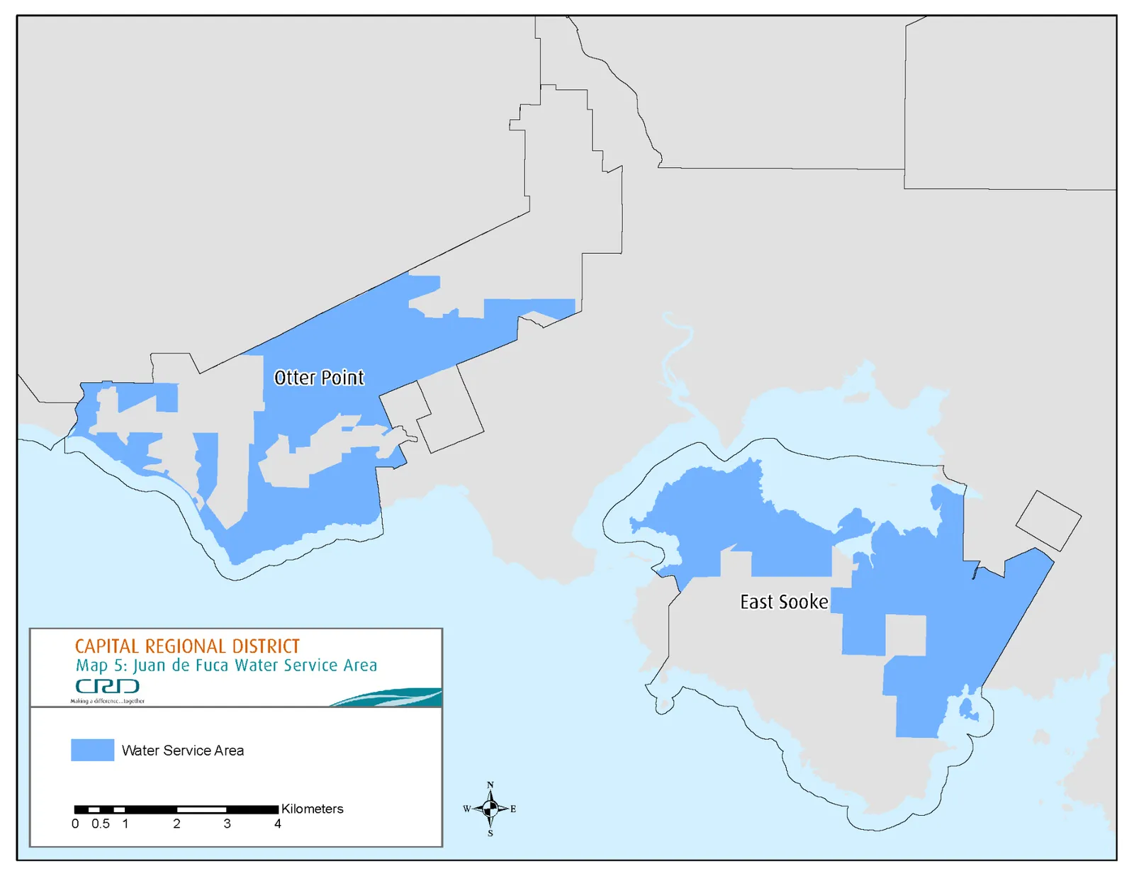
Growth PolicyUrban Containment Policy Area or Rural/Rural Residential Policy Area and the area to be serviced is consistent withOCPOfficial Community Plan servicing provisions and an accepted Regional Context Statement identifies the population to be serviced and how growth in water demand will be addressed. Before approving a new water service bylaw, the full CRD Board must review the request for the new bylaw as it relates to the Regional Growth Strategy and deem the new bylaw consistent with the Regional Growth Strategy. This review is to include a detailed analysis of costs and cost recovery implications, including implications related to parcel taxes, fees, charges and grants, and subject to the principles as noted above. b. For the Juan de Fuca Electoral Area outside the Urban Containment Policy Area, the areas to be serviced are limited to East Sooke and Otter Point as shown on Map 5 as within a Water Service Area,with total development of existing and new units in East Sooke and Otter Point not exceeding 3384 units.shown on RGS Map 3 as either Growth Policy Area or Rural/Rural Residential Policy Area and the area to be serviced is consistent with OCP servicing provisions and the The applicableOCPOfficial Community Plan must identifiesy the population to be serviced and how growth in water demand will be addressed. b.c. For the Juan de Fuca Electoral Area inside the Urban Containment Policy Area, the area to be serviced is shown on Map 3(a) as Urban Containment Policy Area and the area to be serviced is consistent with Official Community Plan servicing provisions and the applicable Official Community Plan identifies the population to be serviced and how growth in water demand will be addressed. Where new water system services are provided to the community of Shirley-Jordan River, areas to be serviced may also include lands shown on RGS Map 3 as Renewable Resource Lands Policy Area and designated in the OCP as Coastal Uplands subject to limiting development potential of serviced parcels to a density of one parcel per four hectares, as set out in the OCP. - Notwithstanding policy 2.2(2), the CRD may extend water service if required to address a pressing public health, public safety or environmental issue relating to existing units or to service agriculture.
- Notwithstanding policy 2.2(2), the CRD may extend water service to service agriculture. Where water service is extended to service agriculture
in Policy 2.2(3), water service may be provided to residential units along the serviced line on lands within the Agricultural Land Reserve as long as an OCP is in place that prevents further subdivision or an increase in permitted residential density. - Do not further extend urban sewer services outside the
Growth PolicyUrban Containment Policy Area Boundary depicted on Map 3(a). - Notwithstanding policies 2.2(2) and 2.2(4), evaluate requests for services from jurisdictions outside of Capital Regional District membership with a view towards supporting mutually beneficial relationships and fostering development consistent with all RGS objectives and policies.
MAP 5: JUAN DE FUCA WATER SERVICE AREA
3. Housing and Community
3.1 Create Safe and Complete Communities
The Regional Growth Strategy supports the development of complete communities within the Growth Policy Urban Containment Policy Area that enable residents to undertake a wider range of daily activities closer to home. It does this by supporting the development of communities that offer a variety of housing types and tenures in proximity to places of work, schools, shopping, recreation, parks and green space. Complete communities provide a better balance and distribution of jobs and housing, a wider choice of affordable housing types, a better distribution of public services and more opportunity to walk, cycle, and use public transit conveniently. Complete communities, are safe, socially diverse, openly accessible, livable and attract economic investment, thereby enhancing social sustainability and health and well-being.
The characteristics of a complete community are highly dependent on context. In some locations, the addition of employment opportunities or commercial services may be required while in others it may be the provision of a greater mix of housing types. In still others, the development of a park, footpaths or cycling facilities may help create a complete community. The criteria for a complete community within the Growth Policy Urban Containment Policy Area are listed below. Outside the Growth Policy Urban Containment Policy Area, the notion of what makes a community complete may be yet different and the criteria set out for complete communities does not apply to the Rural/Rural Residential Policy Area.
Complete Communities Criteria
I. Multiple modes can be used to move to, from and within the community; II. Places of work, shopping, learning, recreation and parks and green space can be easily accessed by a ten minute walk or a fifteen minute bike ride; III. A range of housing types and tenures across the housing spectrum is available for people through all stages of their lives; and IV. The community is demographically diverse, with a mix of people of all ages, incomes and abilities.
Lands vulnerable to natural hazards risks may be located throughout the Growth Management Planning Area. Risks may limit or eliminate development.
Policies
- Identify locations within the
Growth PolicyUrban Containment Policy Area that support the wellbeing of residents, consistent with the Complete Communities Criteria outlined in Objective 3.1, and adopt policies to direct growth to these locations. - Create complete communities consistent with the criteria in Objective 3.1 by adopting policies, developing regulations or pursuing strategies focusing on matters such as densification, mix of uses, diverse housing types and tenures and multi-modal transportation.
- Avoid locating new development in the Growth Management Planning Area in areas with high seismic hazard associated with ground-motion amplification, liquification, slope instability or in areas prone to flooding, or incorporate appropriate engineering and planning measures to mitigate risk.
- Design, manage and construct climate change-adaptive and risk-adaptive infrastructure and utilities in the Growth Management Planning Area.
3.2 Improve Housing Affordability
Maintaining a broad range of affordable housing types and forms is necessary for individual quality of life, community health, and economic competitiveness. Central to affordability is the provision of housing along a broad spectrum that acknowledges different market and non-market tenures, ranging from shelters to social housing, assisted and market rental to home ownership.
Growth management may have mixed results for housing affordability. In urban areas, increased residential densities and an expanded stock of attached housing may enhance affordability by expanding choice and by reducing the need to rely on travel by car to reach services. In rural areas, mobile homes, secondary suites and detached accessory suites may provide more affordable housing.
Growth management measures could have the effect of limiting the supply of new lands for the urban housing market, thereby putting upward pressure on housing prices, particularly for single detached homes. The provision of affordable housing to accommodate the anticipated population increase is the responsibility of many stakeholders including the Capital Regional District, local and senior levels of government, industry and the not-for profit sector.
The Capital Region Housing Corporation will continue to provide affordable housing to meet the needs associated with anticipated population growth, recognizing that implementation relies on funding and partnerships with other stakeholders. In addition to the provision of affordable housing, the Regional Housing Affordability Strategy has been developed to support all residents of the Capital Region – especially low and moderate-income households, the elderly, youth, those with special health and other needs, and the homeless – to have reasonable choice of housing by type, tenure, price and location. Five approaches to housing affordability underlie the Regional Housing Affordability Strategy.
Approaches to Housing Affordability
I. Work across the housing spectrum when identifying the current and anticipated future issues concerning market and non-market housing affordability for no, low and middle income and special needs households; II. Analyze the extent of present issues and forecast future problems; III. Focus on developing practical policies, and gaining commitments to action to address identified needs and problems in the short, medium and long term across the Capital Region; IV. Involve the broader community in the development of the strategy and its recommended solutions; and, V. Act as a catalyst for activities to improve housing affordability in the Capital Region.
Policies
- Provide for an adequate, accessible and diverse supply of affordable housing across the housing spectrum.
4. Transportation
4.1 Improve Multi-Modal Connectivity and Mobility
The Regional Growth Strategy supports the development of a balanced and sustainable transportation system providing residents with reasonable and affordable transportation choices that enhance overall regional quality of life. Increasing congestion and travel delays and desires for a more effective, connected, sustainable and multi-modal transportation system are of central concern to regional residents. The majority of transportation movements in the region cross municipal boundaries. Although some transportation issues can be addressed at the local level, resolution of most transportation challenges will require collaborative, multi-jurisdictional, region-wide action.
To improve multi-modal connectivity and mobility, the Regional Growth Strategy relies on two related initiatives. First, the coordination of land use and transportation so that the majority of regional residents do not have to rely solely on travel by automobile to meet their daily needs. The Regional Growth Strategy’s aim to keep urban settlement compact and build complete communities (Objectives 1.1 and 3.1) will tend to increase average urban densities and put people and their activities (homes, jobs, services) closer together. Creating communities where housing is close to activities will enhance opportunities for using walking, cycling, and public transit to meet daily needs.
Secondly, transportation choice will be enhanced with the planning, development and implementation of the Regional Multi-Modal Network identified in the Regional Transportation Plan. The Regional Transportation Plan provides actions and outcomes to develop an effective inter-municipal arterial road network that provides travel choices and supports smart growth and livable, complete communities. Implementing the Regional Multi-Modal Network is the responsibility of many actors, including the Capital Regional District, local and senior levels of government and BC Transit. Seven principles guide the Regional Transportation Plan and support the multi-modal and connected approach to transportation across the region.
Principles
I. Take a coordinated and engaged approach to transportation and land use planning; II. Prioritize strategic investments that serve regional mobility needs; III. Reduce greenhouse gas emissions and prepare for climate change; IV. Integrate transportation and land use planning; V. Capitalize on the potential for alternatives to driving alone; VI. Enhance the role for public transit; and VII. Maximize efficiency of existing transportation corridors for multiple modes.
Policies
- Implement the Regional Transportation Plan in accordance with the principles outlined in Objective 4.1.
- Locate growth and major trip-generating uses where such can be efficiently serviced by transit and active transportation.
- Prioritize transit and active modes in community planning and in the design and implementation of infrastructure, facilities and programs. 3.4. Advocate for improved public transit to major employment centres, complete communities and transportation hubs in the region.