Council Report: DEVELOPMENT PERMIT 2015/12 – 102 ATKINS ROAD
Staff report recommending approval of a development permit for a nine-unit multifamily residential project at 102 Atkins Road.
Council Report
TO: Mayor & Council DATE: January 27, 2016 FROM: J. Chow, Senior Planner MEETING DATE: February 2, 2016 FILE NO.: 3060-20-2015/12
DEVELOPMENT PERMIT 2015/12 – 102 ATKINS ROAD
RECOMMENDATION:
THAT Development Permit 2015/12 be approved as per the plans and reports attached to the January 27, 2016 report from the Senior Planner titled “Development Permit Application 2015/12 – 102 Atkins Road”;
AND THAT Development Permit 2015/12 include the following conditions:
- Tree protection measures as recommended by the project arborist to be in place prior to issuance of building permits
- Landscape cost estimate to be provided prior to development permit issuance
AND FURTHER THAT Development Permit 2015/12 include the following variance:
- Variance to the minimum rear yard setback for a hydro kiosk from 7.0 m to 0.0 m
CHIEF ADMINISTRATIVE OFFICER’S COMMENTS:
I concur with the recommendation.
DIRECTOR OF DEVELOPMENT SERVICES’ COMMENTS:
I concur with the recommendation.
PURPOSE OF REPORT:
To consider a Form & Character development permit application for a nine unit multifamily development. A variance is requested for the location of three surplus parking spaces.
BACKGROUND:
The 6400m² subject property is located in the Atkins neighbourhood between the E & N Rail Corridor and Galloping Goose Trail. A demolition permit has been issued for a single family dwelling located at the east end of the parcel. The site is long and triangular, coming to a point at the west end, where second growth trees have been established on and around the parcel. There is a large rock outcrop and small grove of Garry oaks at the east end. Adjacent land uses are single family residential but none adjoin the site because it is separated by three different transportation rights-of-way. The property was rezoned to the site-specific CD-21: Detached Multiple-Unit Residential zone in June 2015 to facilitate the proposed development. September 8, 2015
PROPOSAL:
The applicant proposes to construct a multifamily residential development comprised of nine detached strata units as shown in Attachments 3-15. The units would be two storey single family dwellings each with an attached single car garage and a surface parking space in front. Seven additional parking spaces are proposed in order minimize the potential for visitor parking in the neighbourhood.
A driveway from the newly renamed Fagan Place (formerly a disconnected stub of Chilco Road) provides access through the site along the south property line. A large area at west end of the site is to be preserved as natural green space and storm water retention. A rock bluff at the site entrance will be blasted to provide appropriate and create a suitable building site. Environmental, geotechnical and traffic issues were addressed at the time of rezoning.
A variance is requested for the siting of three surplus parking space from a lot line from 1.2m to 0m.
ANALYSIS:
There are three principle considerations for this development permit application: a) How does the proposal address the applicable development permit guidelines? b) How does the proposal meet Zoning Bylaw requirements? c) Is the requested variance supportable?
A. Development Permit Area Guidelines
The parcel is within the Mixed Residential Development Permit Area for the regulation of form and character of development. Overall, the proposal is in accordance with the relevant guidelines of the Mixed Residential Development Permit Area (see Attachment 17).
The site design was driven by a number of factors, primarily the challenging lot shape. The building configuration was design with the assistance of a certified arborist to minimize tree impacts on the property (27 trees retained, 21-23 to be removed) and offsite. A rocky outcrop with Arbutus and Douglas fir trees would be retained to provide a natural buffer that would split the groupings of buildings. The result is a unique housing form that is distinct from the standard townhouse configuration by providing residences in the form and privacy of single family residence, suitable for people that are unable or do not wish to manage a large yard.
B. Zoning Compliance
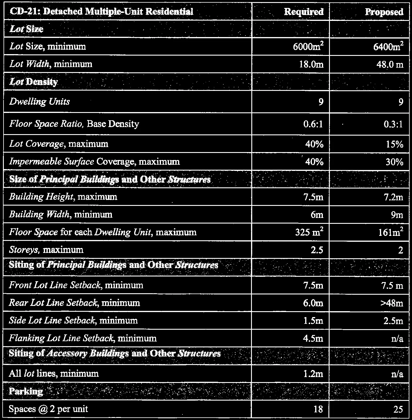
The site is subject to the requirements of the CD-21: Detached Multiple-Unit Residential zone. Table 1 summarizes Zoning Bylaw compliance. A variance for the location of off-street parking is requested.
Table 1. Zoning Review
| CD-21: Detached Multiple-Unit Residential | Required | Proposed |
|---|---|---|
| Lot Size | ||
| Lot Size, minimum | 6000m² | 6400m² |
| Lot Width, minimum | 18.0m | 48.0 m |
| Lot Density | ||
| Dwelling Units | 9 | 9 |
| Floor Space Ratio, Base Density | 0.6:1 | 0.3:1 |
| Lot Coverage, maximum | 40% | 15% |
| Impermeable Surface Coverage, maximum | 40% | 30% |
| Size of Principal Buildings and Other Structures | ||
| Building Height, maximum | 7.5m | 7.2m |
| Building Width, minimum | 6m | 9m |
| Floor Space for each Dwelling Unit, maximum | 325 m² | 161m² |
| Storeys, maximum | 2.5 | 2 |
| Siting of Principal Buildings and Other Structures | ||
| Front Lot Line Setback, minimum | 7.5m | 7.5 m |
| Rear Lot Line Setback, minimum | 6.0m | >48m |
| Side Lot Line Setback, minimum | 1.5m | 2.5m |
| Flanking Lot Line Setback, minimum | 4.5m | n/a |
| Siting of Accessory Buildings and Other Structures | ||
| All lot lines, minimum | 1.2m | n/a |
| Parking | ||
| Spaces @ 2 per unit | 18 | 25 |
C. Requested Variance
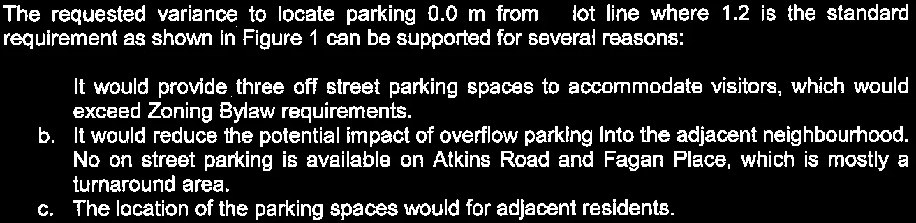
The requested variance to locate parking 0.0 m from a lot line where 1.2 is the standard requirement as shown in Figure 1 can be supported for several reasons:
a. It would provide three off street parking spaces to accommodate visitors, which would exceed Zoning Bylaw requirements. b. It would reduce the potential impact of overflow parking into the adjacent neighbourhood. No on street parking is available on Atkins Road and Fagan Place, which is mostly a turnaround area. c. The location of the parking spaces would for adjacent residents.
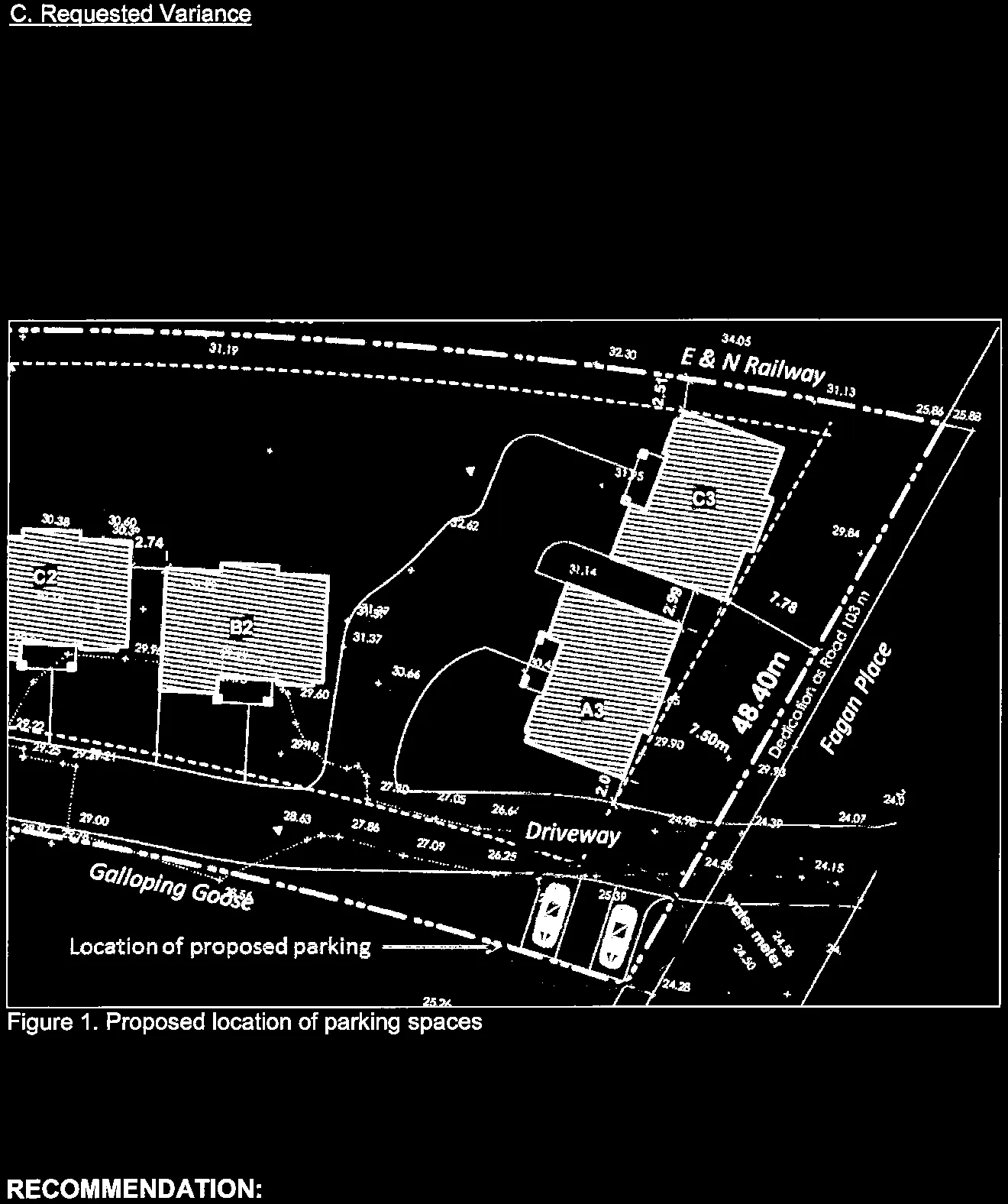
If the variance is not supported, one parallel parking space could be provided in this location in compliance with Zoning Bylaw requirements for the siting of parking.
RECOMMENDATION:
THAT Development Permit 2015/12 be approved as per the plans and reports attached to the January 27, 2016 report from the Senior Planner titled “Development Permit Application 2015/12 – 102 Atkins Road”;
AND THAT Development Permit 2015/12 include the following conditions:
- Tree protection measures as recommended by the project arborist to be in place prior to issuance of building permits
- Landscape cost estimate to be provided prior to development permit issuance
AND FURTHER THAT Development Permit 2015/12 include the following variance:
- Variance to the minimum rear yard setback for a hydro kiosk from 7.0 m to 0.0 m
SUBMITTED BY: J. Chow, MCIP, RPP, Senior Planner REVIEWED BY: L. Chase, MCIP, RPP, Director of Development Services
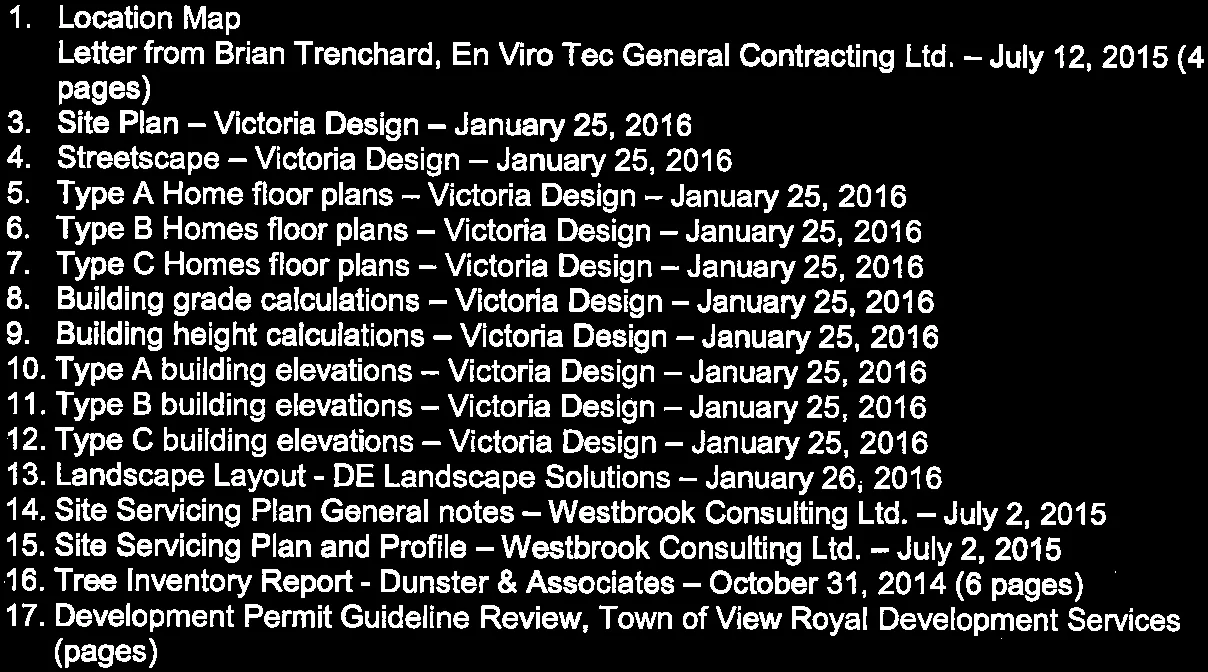
ATTACHMENTS:
- Location Map
- Letter from Brian Trenchard, En Viro Tec General Contracting Ltd. – July 12, 2015 (4 pages)
- Site Plan – Victoria Design – January 25, 2016
- Streetscape – Victoria Design – January 25, 2016
- Type A Home floor plans – Victoria Design – January 25, 2016
- Type B Homes floor plans – Victoria Design – January 25, 2016
- Type C Homes floor plans – Victoria Design – January 25, 2016
- Building grade calculations – Victoria Design – January 25, 2016
- Building height calculations – Victoria Design – January 25, 2016
- Type A building elevations – Victoria Design – January 25, 2016
- Type B building elevations – Victoria Design – January 25, 2016
- Type C building elevations – Victoria Design – January 25, 2016
- Landscape Layout – DE Landscape Solutions – January 26, 2016
- Site Servicing Plan General notes – Westbrook Consulting Ltd. – July 2, 2015
- Site Servicing Plan and Profile – Westbrook Consulting Ltd. – July 2, 2015
- Tree Inventory Report – Dunster & Associates – October 31, 2014 (6 pages)
- Development Permit Guideline Review, Town of View Royal Development Services (pages)
Document Images
(14)