Appendix
Attachment 15 - Site Servicing Plan and Profile
February 2, 2016Page 411 section
Engineering drawings showing the underground utility profiles and plan view for site servicing.
June 2015Road A Profile included
Attachment 15
Road Plan and Profile - 102 Atkins
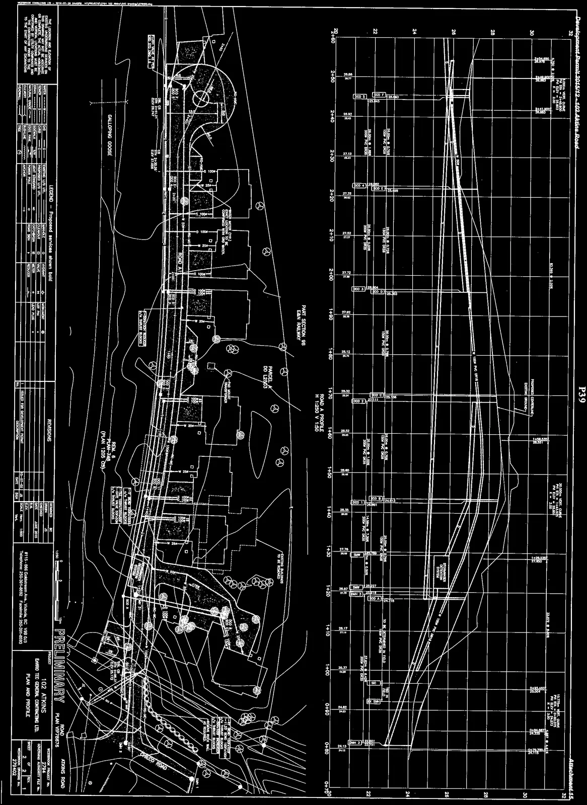
Legend - Proposed services shown bold
| Feature | Line/Symbol | Feature | Line/Symbol |
|---|---|---|---|
| WATER | --- W --- | EXISTING U/G UTIL | --- --- |
| SEWER | --- S --- | PROPOSED U/G UTIL | --- --- |
| DRAIN | --- D --- | LIGHT STANDARD | (symbol) |
| NATURAL GRADE | --- --- | POWER POLE | (symbol) |
| CULVERT | ===== | ANCHOR | (symbol) |
| HEADWALL | --- < --- | MANHOLE | (square) |
| GAS | --- G --- | CLEANOUT | (circle) |
| CURB | --- C --- | CATCHBASIN | (circle with grid) |
| SIDEWALK | --- SW --- | ROAD SIGN | (symbol) |
| EDGE PAVE | --- EP --- | HYDRANT | (asterisk) |
| BUSHLINE | --- B --- | VALVE | (bowtie) |
| TREE | (tree symbol) | METER | (square with M) |
| REDUCER | (symbol) | ||
| MONUMENT | (circle with dot) | ||
| LOT PIN | (dot) | ||
| LEAD PLUG | (dot) |
Project Information
- Project: 102 ATKINS
- Client: EN VIRO TEC GENERAL CONTRACTING LTD.
- Location: TOWN OF VIEW ROYAL
- Consultant: Westbrook Consulting Ltd., #115 - 866 Goldstream Ave., Victoria, BC V9B 0J3
- Date: JUNE 2015
- Scale: Horiz. 1:500, Vert. 1:100
- Westbrook Project No: 2794
- Drawing No: 279402
- Sheet: 2 of 2
Page 41
Document Images
(1)
Extracted from: 2016 02 02 Council Agenda - Pdf