Proposed Development Permit Amendment Drawings
New architectural drawings and site plans submitted for the amendment application, highlighting changes made to the buildings and landscaping.
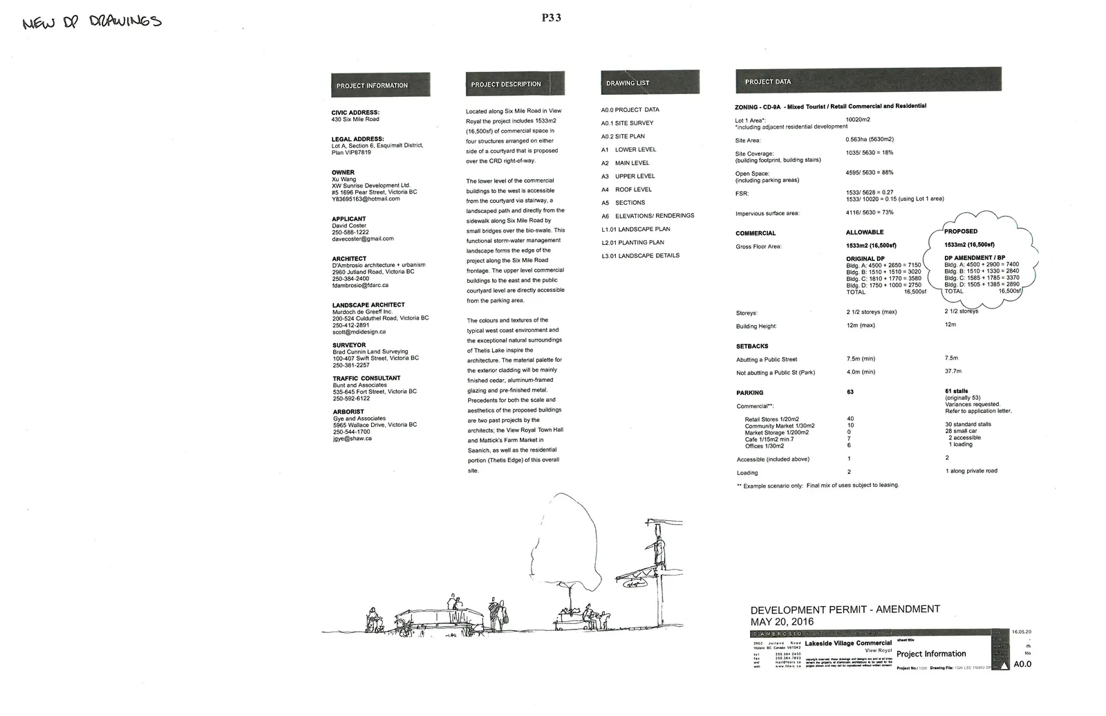
Project Information
CIVIC ADDRESS: 430 Six Mile Road
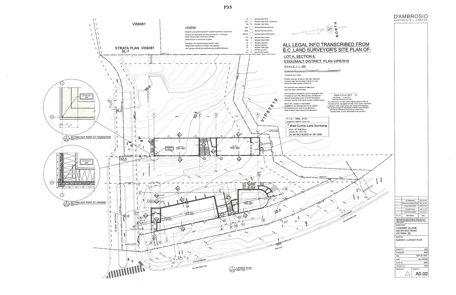
LEGAL ADDRESS: Lot A, Section 6, Esquimalt District, Plan VIP87819
OWNER: Xu Wang XW Sunrise Development Ltd. #5 1696 Pearl Street, Victoria BC V83695163@hotmail.com
APPLICANT: David Coster 250-588-1222 davecoster@gmail.com
ARCHITECT: D'Ambrosio architecture + urbanism 2960 Jutland Road, Victoria BC 250-384-2400 fdambrosio@fdarc.ca
LANDSCAPE ARCHITECT: Murdoch de Greeff Inc. 200-524 Culduthel Road, Victoria BC 250-412-2891 scott@mdidesign.ca
SURVEYOR: Brad Cunnin Land Surveying 100-407 Swift Street, Victoria BC 250-381-2257
TRAFFIC CONSULTANT: Bunt and Associates 535-645 Fort Street, Victoria BC 250-592-6122
ARBORIST: Gye and Associates 5965 Wallace Drive, Victoria BC 250-544-1700 jgye@shaw.ca
Project Description
Located along Six Mile Road in View Royal the project includes 1533m2 (16,500sf) of commercial space in four structures arranged on either side of a courtyard that is proposed over the CRD right-of-way.
The lower level of the commercial buildings to the west is accessible from the courtyard via stairway, a landscaped path and directly from the sidewalk along Six Mile Road by small bridges over the bio-swale. This functional storm-water management landscape forms the edge of the project along the Six Mile Road frontage. The upper level commercial buildings to the east and the public courtyard level are directly accessible from the parking area.
The colours and textures of the typical west coast environment and the exceptional natural surroundings of Thetis Lake inspire the architecture. The material palette for the exterior cladding will be mainly finished cedar, aluminum-framed glazing and pre-finished metal. Precedents for both the scale and aesthetics of the proposed buildings are two past projects by the architects: the View Royal Town Hall and Mattick's Farm Market in Saanich, as well as the residential portion (Thetis Edge) of this overall site.
Drawing List
- A0.0 PROJECT DATA
- A0.1 SITE SURVEY
- A0.2 SITE PLAN
- A1 LOWER LEVEL
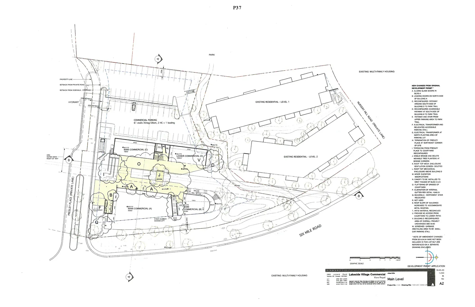
- A2 MAIN LEVEL
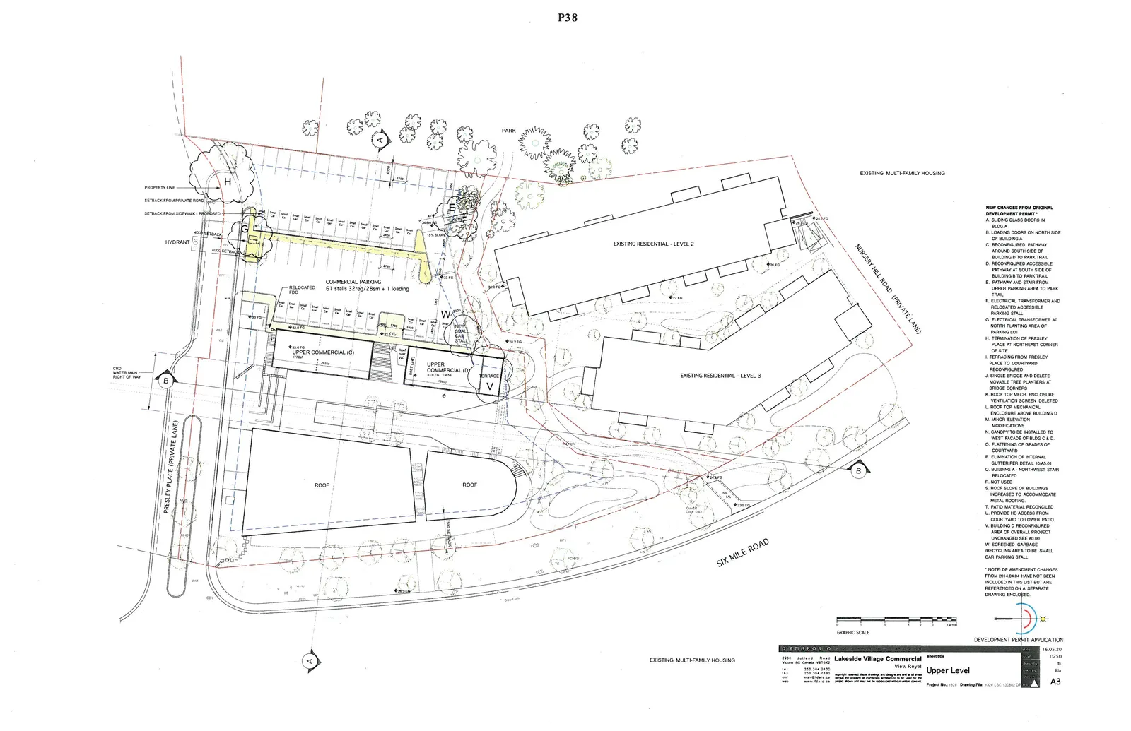
- A3 UPPER LEVEL
- A4 ROOF LEVEL
- A5 SECTIONS
- A6 ELEVATIONS/ RENDERINGS
- L1.01 LANDSCAPE PLAN
- L2.01 PLANTING PLAN
- L3.01 LANDSCAPE DETAILS
Project Data
ZONING - CD-9A - Mixed Tourist / Retail Commercial and Residential
| Item | Data |
|---|---|
| Lot 1 Area*: | 10020m2 |
| *including adjacent residential development | |
| Site Area: | 0.563ha (5630m2) |
| Site Coverage: | 1035 / 5630 = 18% |
| (building footprint, building stairs) | |
| Open Space: | 4595 / 5630 = 88% |
| (including parking areas) | |
| FSR: | 1533 / 5628 = 0.27 |
| 1533 / 10020 = 0.15 (using Lot 1 area) | |
| Impervious surface area: | 4116 / 5630 = 73% |
COMMERCIAL
| Category | ALLOWABLE | PROPOSED |
|---|---|---|
| Gross Floor Area: | 1533m2 (16,500sf) | 1533m2 (16,500sf) |
| ORIGINAL DP | DP AMENDMENT / BP | |
| Bldg. A: 4500 + 2650 = 7150 | Bldg. A: 4500 + 2900 = 7400 | |
| Bldg. B: 1510 + 1510 = 3020 | Bldg. B: 1510 + 1330 = 2840 | |
| Bldg. C: 1810 + 1770 = 3580 | Bldg. C: 1585 + 1785 = 3370 | |
| Bldg. D: 1750 + 1000 = 2750 | Bldg. D: 1505 + 1385 = 2890 | |
| TOTAL: 16,500sf | TOTAL: 16,500sf | |
| Storeys: | 2 1/2 storeys (max) | 2 1/2 storeys |
| Building Height: | 12m (max) | 12m |
SETBACKS
| Setback | Required | Proposed |
|---|---|---|
| Abutting a Public Street | 7.5m (min) | 7.5m |
| Not abutting a Public St (Park) | 4.0m (min) | 37.7m |
PARKING
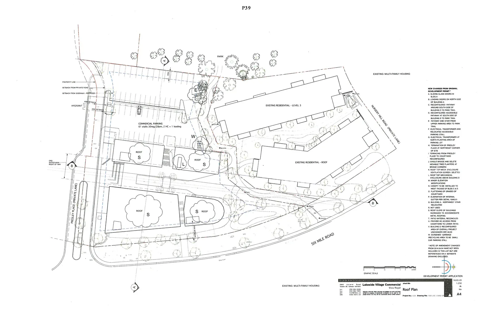
Commercial**: 63 Required | 61 stalls (originally 53) Variances requested. Refer to application letter.
| Stall Type | Count |
|---|---|
| Retail Stores 1/20m2 | 40 |
| Community Market 1/30m2 | 10 |
| Market Storage 1/200m2 | 0 |
| Cafe 1/15m2 min. 7 | 7 |
| Offices 1/30m2 | 6 |
| Standard stalls | 30 |
| Small car | 28 |
| Accessible (included above) | 2 |
| Loading | 1 along private road |
** Example scenario only: Final mix of uses subject to leasing.
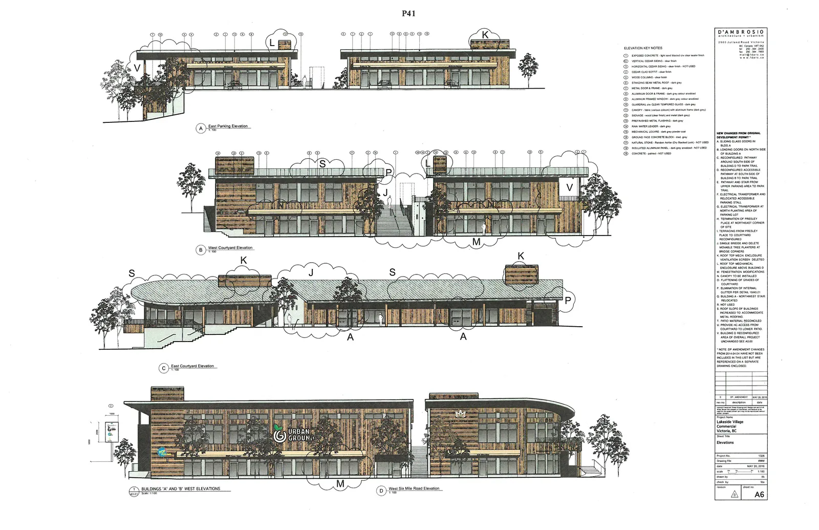
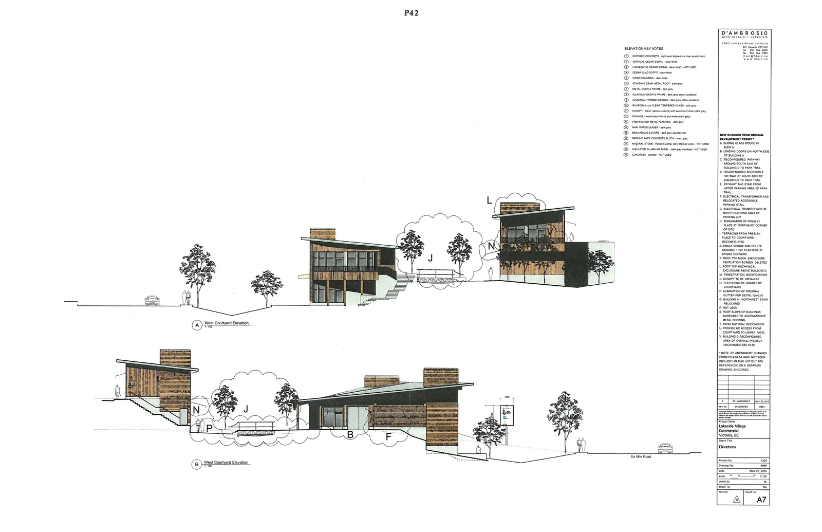
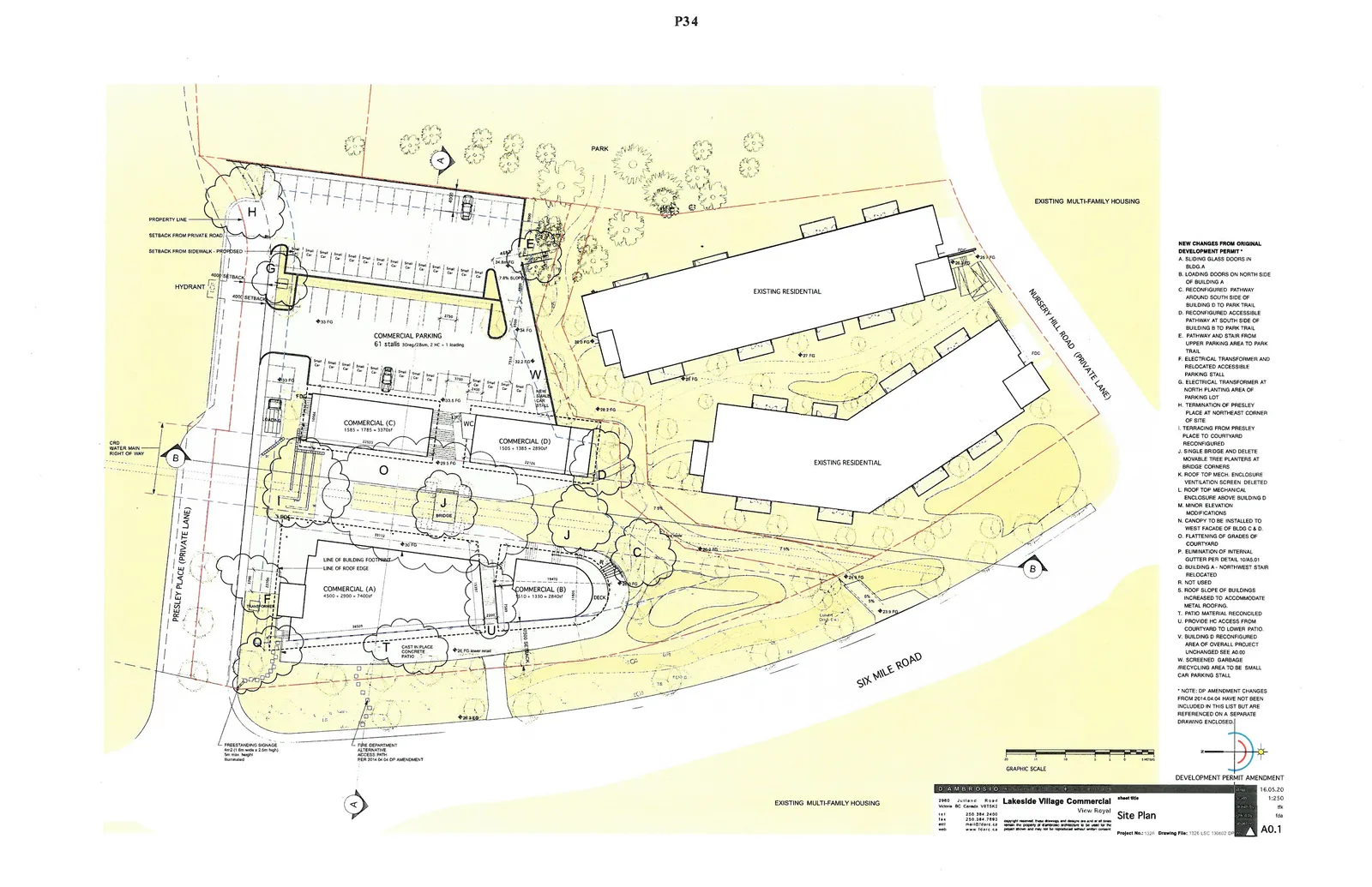
New Changes From Original Development Permit
- A. SLIDING GLASS DOORS IN BLDG A
- B. LOADING DOORS ON NORTH SIDE OF BUILDING A
- C. RECONFIGURED PATHWAY AROUND SOUTH SIDE OF BUILDING D TO PARK TRAIL
- D. RECONFIGURED ACCESSIBLE PATHWAY AT SOUTH SIDE OF BUILDING B TO PARK TRAIL
- E. PATHWAY AND STAIR FROM UPPER PARKING AREA TO PARK TRAIL
- F. ELECTRICAL TRANSFORMER AND RELOCATED ACCESSIBLE PARKING STALL
- G. ELECTRICAL TRANSFORMER AT NORTH PLANTING AREA OF PARKING LOT
- H. TERMINATION OF PRESLEY PLACE AT NORTHEAST CORNER OF SITE
- I. TERRACING FROM PRESLEY PLACE TO COURTYARD RECONFIGURED
- J. SINGLE BRIDGE AND DELETE MOVABLE TREE PLANTERS AT BRIDGE CORNERS
- K. ROOF TOP MECH. ENCLOSURE VENTILATION SCREEN DELETED
- L. ROOF TOP MECHANICAL ENCLOSURE ABOVE BUILDING D
- M. MINOR ELEVATION MODIFICATIONS
- N. CANOPY TO BE INSTALLED TO WEST FACADE OF BLDG C & D
- O. FLATTENING OF GRADES OF COURTYARD
- P. ELIMINATION OF INTERNAL GUTTER PER DETAIL 10/A5.01
- Q. BUILDING A - NORTHWEST STAIR RELOCATED
- R. NOT USED
- S. ROOF SLOPE OF BUILDINGS INCREASED TO ACCOMMODATE METAL ROOFING
- T. PATIO MATERIAL RECONCILED
- U. PROVIDE HC ACCESS FROM COURTYARD TO LOWER PATIO
- V. BUILDING D RECONFIGURED AREA OF OVERALL PROJECT UNCHANGED SEE A0.00
- W. SCREENED GARBAGE /RECYCLING AREA TO BE SMALL CAR PARKING STALL
Site Plan
Survey / Layout Plan
ALL LEGAL INFO TRANSCRIBED FROM B.C. LAND SURVEYOR'S SITE PLAN OF: LOT A, SECTION 6, ESQUIMALT DISTRICT, PLAN VIP87819 SCALE = 1 : 200
LEGEND
- UP - denotes Utility Pole
- UPT - denotes Utility Pole / Transformer
- CB - denotes Catch Basin
- MHS - denotes Manhole (Sanitary)
- MHD - denotes Manhole (Storm)
- BCHYD - denotes Manhole (BC Hydro)
- WV - denotes Water Valve
- WM - denotes Water Meter
- LB - denotes Light Box
- TS - denotes Traffic Sign
- G - denotes guy wire
- FH - denotes fire hydrant
Lower Level Plan
Main Level Plan
Upper Level Plan
Roof Plan
Sections
Elevations
ELEVATION KEY NOTES
- EXPOSED CONCRETE - light sand blasted c/w clear sealer finish
- VERTICAL CEDAR SIDING - clear finish
- HORIZONTAL CEDAR SIDING - clear finish - NOT USED
- CEDAR CLAD SOFFIT - clear finish
- WOOD COLUMNS - clear finish
- STANDING SEAM METAL ROOF - dark grey
- METAL DOOR & FRAME - dark grey
- ALUMINUM DOOR & FRAME - dark grey colour anodized
- ALUMINUM FRAMED WINDOW - dark grey colour anodized
- GUARDRAIL c/w CLEAR TEMPERED GLASS - dark grey
- CANOPY - fabric (various colours) with aluminum frame (dark grey)
- SIGNAGE - wood (clear finish) and metal (dark grey)
- PREFINISHED METAL FLASHING - dark grey
- RAIN WATER LEADER - dark grey
- MECHANICAL LOUVRE - dark grey powder coat
- GROUND FACE CONCRETE BLOCK - med. grey
- NATURAL STONE - Rundle Ashlar (Dry Stacked Look) - NOT USED
- INSULATED ALUMINUM PANEL - dark grey anodized - NOT USED
- CONCRETE - painted - NOT USED