Appendix
Six Mile Road Plan Profile - Sewer and Drain
July 19, 2016Page 501 section
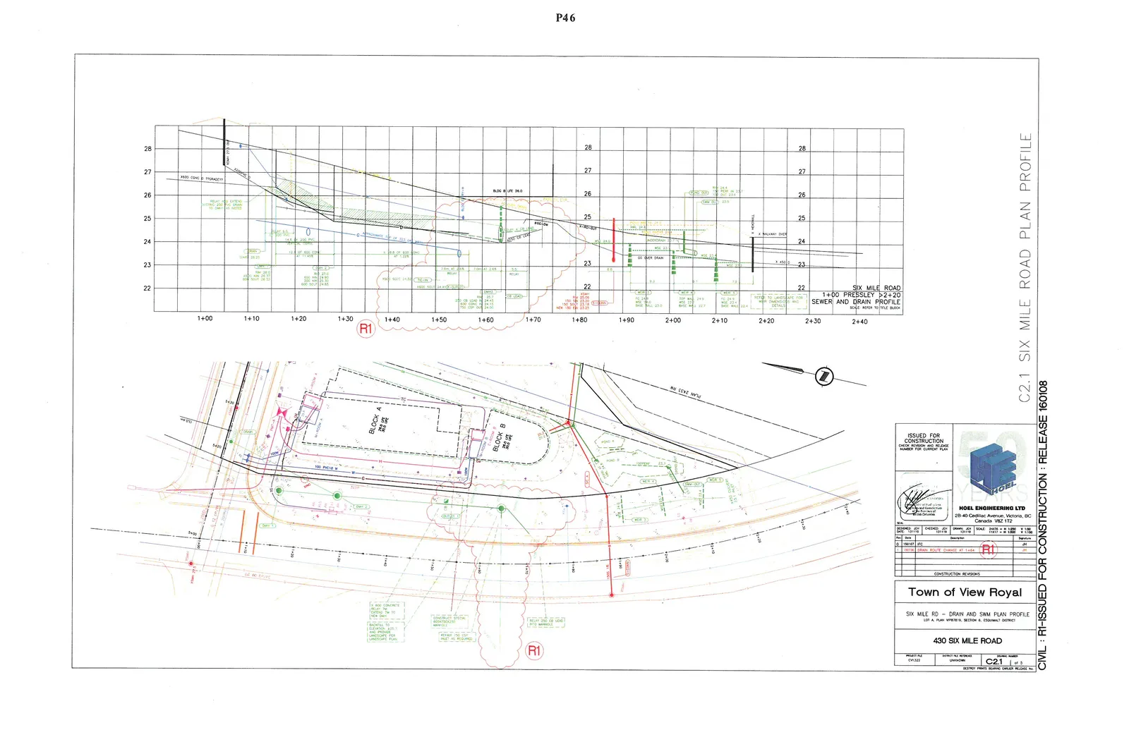
Engineering plan profile showing underground sewer and drainage infrastructure along Six Mile Road.
Hoel Engineering Ltd.
SIX MILE ROAD PLAN PROFILE
Profile View
The profile section spans from station 1+00 to 2+40 with elevations ranging from 22.0 to 28.0 meters. Key features and annotations include:
- Station 1+00 to 1+40: 600 CONC D. (DRAIN), 150 PVC DRAIN, 100 PVC W, and existing ground line.
- Station 1+40 to 1+60 (Revision R1): Indicates a drainage route change. Notes include "TIE-IN", "CB LEAD", and "CONSTRUCT SPECIAL 600x750x250 MANHOLE".
- Station 1+60 to 2+00: 250 PVC DRAIN, "RELAY 250 CB LEAD", and labels for "WEIR 3".
- Station 2+00 to 2+40: Structures including "WEIR 4", "WEIR 5", "POND OUT", "HEADWALL", and "WALKWAY OVER".
- WEIR 3: T.O.W. 24.2, BASE 23.0
- WEIR 4: T.O.W. 24.9, BASE 23.7
- WEIR 5: T.O.W. 24.5, BASE 22.4
- POND OUT: IE IN 23.7, IE OUT 23.4
Plan View
The plan view illustrates the layout of Six Mile Road, "BLOCK A", and "BLOCK B". Annotations include:
- Infrastructure: 100 PVC W, 150 PVC DRAIN, 600 CONC D, various catch basins (CB), and manholes.
- Revision 1 (R1): Located near Station 1+44, showing a modified drain route. Notes include:
- "RELAY 7M - EXTEND TM TO NEW DMH"
- "BACKFILL TO ELEVATION ±23.7 AND PROVIDE LANDSCAPE PER LANDSCAPE PLAN"
- "CONSTRUCT SPECIAL 600x750x250 MANHOLE"
- "RELAY 250 CB LEAD INTO MANHOLE"
- "REPAIR 150 CB INLET AS REQUIRED"
- Landscape Features: "POND A" and designated weir locations (WEIR 3, WEIR 4, WEIR 5).
Revisions
| No. | Date | Description | By |
|---|---|---|---|
| 0 | 160107 | IFC | JDH |
| 1 | 171116 | DRAIN ROUTE CHANGE AT 1+44 | JDH |
Project Information
- Municipality: Town of View Royal
- Project: SIX MILE RD - DRAIN AND SWM PLAN PROFILE
- Location: LOT A, PLAN VIP87870, SECTION 8, ESQUIMALT DISTRICT
- Address: 430 SIX MILE ROAD
- Engineering Firm: HOEL ENGINEERING LTD, 28-40 Cadillac Avenue, Victoria, BC, Canada V8Z 1T2
- Designed: JDH
- Checked: JDH
- Drawn: JDH
- Date: 131119
- Scale: 1:250 H, 1:50 V
- Project No: CV-322
- Drawing Number: C21
- Sheet: 1 of 5
- Status: ISSUED FOR CONSTRUCTION: RELEASE 160108
Page 50
Extracted from: 2016 07 19 Council Agenda - Pdf