Staff Report: DEVELOPMENT PERMIT 2016/05 – 1950 Watkiss Way
A comprehensive report on a development permit application for a mixed-use building consisting of commercial space and 44 rental units.
Council Report
TO: Mayor & Council DATE: July 13, 2016 FROM: J. Chow, Senior Planner MEETING DATE: July 19, 2016 FILE NO.: 3060-20-2016/05
DEVELOPMENT PERMIT 2016/05 – 1950 Watkiss Way
RECOMMENDATION
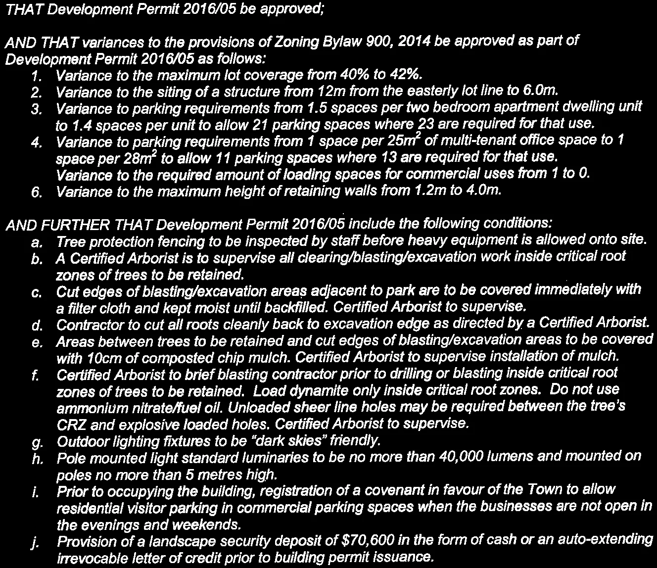
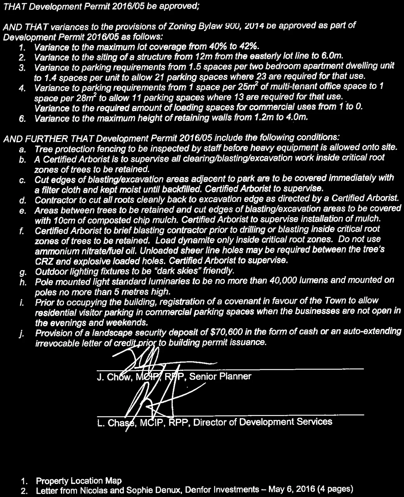
THAT Development Permit 2016/05 be approved;
AND THAT variances to the provisions of Zoning Bylaw 900, 2014 be approved as part of Development Permit 2016/05 as follows:
- Variance to the maximum lot coverage from 40% to 42%.
- Variance to the siting of a structure from 12m from the easterly lot line to 6.0m.
- Variance to parking requirements from 1.5 spaces per two bedroom apartment dwelling unit to 1.4 spaces per unit to allow 21 parking spaces where 23 are required for that use.
- Variance to parking requirements from 1 space per $25m^2$ of multi-tenant office space to 1 space per $28m^2$ to allow 11 parking spaces where 13 are required for that use.
- Variance to the required amount of loading spaces for commercial uses from 1 to 0.
- Variance to the maximum height of retaining walls from 1.2m to 4.0m.
AND FURTHER THAT Development Permit 2016/05 include the following conditions: a. Tree protection fencing to be inspected by staff before heavy equipment is allowed onto site. b. A Certified Arborist is to supervise all clearing/blasting/excavation work inside critical root zones of trees to be retained. c. Cut edges of blasting/excavation areas adjacent to park are to be covered immediately with a filter cloth and kept moist until backfilled. Certified Arborist to supervise. d. Contractor to cut all roots cleanly back to excavation edge as directed by a Certified Arborist. e. Areas between trees to be retained and cut edges of blasting/excavation areas to be covered with 10cm of composted chip mulch. Certified Arborist to supervise installation of mulch. f. Certified Arborist to brief blasting contractor prior to drilling or blasting inside critical root zones of trees to be retained. Load dynamite only inside critical root zones. Do not use ammonium nitrate/fuel oil. Unloaded sheer line holes may be required between the tree's CRZ and explosive loaded holes. Certified Arborist to supervise. g. Outdoor lighting fixtures to be "dark skies" friendly. h. Pole mounted light standard luminaries to be no more than 40,000 lumens and mounted on poles no more than 5 metres high. i. Prior to occupying the building, registration of a covenant in favour of the Town to allow residential visitor parking in commercial parking spaces when the businesses are not open in the evenings and weekends. j. Provision of a landscape security deposit of $70,600 in the form of cash or an auto-extending irrevocable letter of credit prior to building permit issuance.
PURPOSE OF REPORT:
To consider a development permit application for a four storey commercial/residential mixed use building comprised of $305m^2$ of commercial office space on the ground floor and 44 rental apartment units on the upper three floors. Variances are also requested.
BACKGROUND:
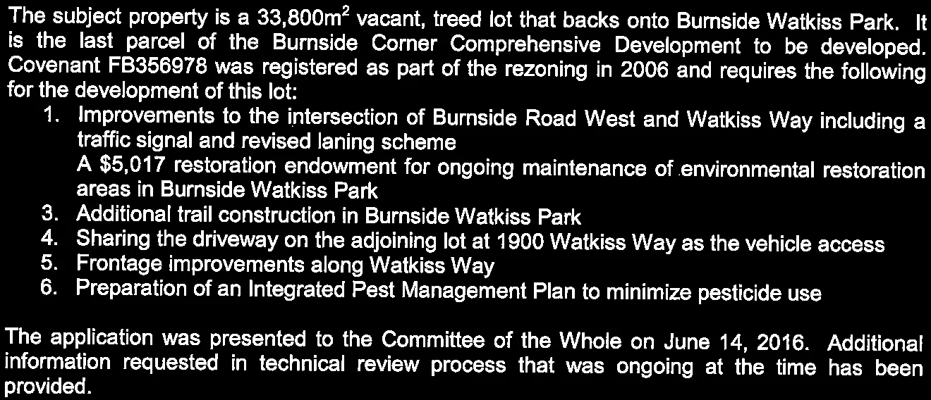
The subject property is a $33,800m^2$ vacant, treed lot that backs onto Burnside Watkiss Park. It is the last parcel of the Burnside Corner Comprehensive Development to be developed. Covenant FB356978 was registered as part of the rezoning in 2006 and requires the following for the development of this lot:
- Improvements to the intersection of Burnside Road West and Watkiss Way including a traffic signal and revised laning scheme
- A $5,017 restoration endowment for ongoing maintenance of environmental restoration areas in Burnside Watkiss Park
- Additional trail construction in Burnside Watkiss Park
- Sharing the driveway on the adjoining lot at 1900 Watkiss Way as the vehicle access
- Frontage improvements along Watkiss Way
- Preparation of an Integrated Pest Management Plan to minimize pesticide use
The application was presented to the Committee of the Whole on June 14, 2016. Additional information requested in technical review process that was ongoing at the time has been provided.
PROPOSAL:
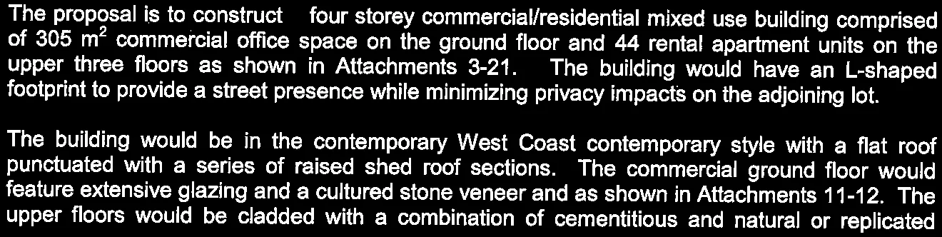
The proposal is to construct a four storey commercial/residential mixed use building comprised of $305 \text{ m}^2$ commercial office space on the ground floor and 44 rental apartment units on the upper three floors as shown in Attachments 3-21. The building would have an L-shaped footprint to provide a street presence while minimizing privacy impacts on the adjoining lot.
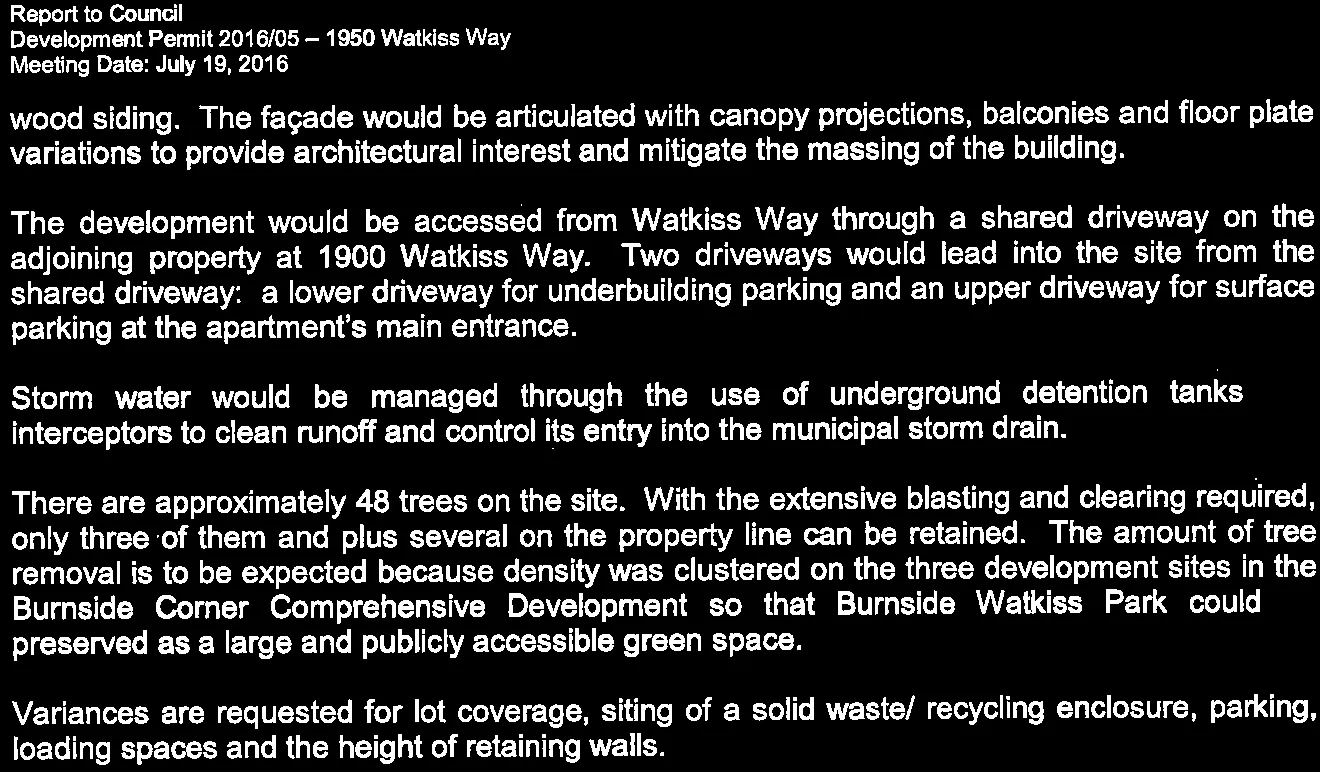
The building would be in the contemporary West Coast contemporary style with a flat roof punctuated with a series of raised shed roof sections. The commercial ground floor would feature extensive glazing and a cultured stone veneer and as shown in Attachments 11-12. The upper floors would be cladded with a combination of cementitious and natural or replicated wood siding. The façade would be articulated with canopy projections, balconies and floor plate variations to provide architectural interest and mitigate the massing of the building.
The development would be accessed from Watkiss Way through a shared driveway on the adjoining property at 1900 Watkiss Way. Two driveways would lead into the site from the shared driveway: a lower driveway for underbuilding parking and an upper driveway for surface parking at the apartment’s main entrance.
Storm water would be managed through the use of underground detention tanks and interceptors to clean runoff and control its entry into the municipal storm drain.
There are approximately 48 trees on the site. With the extensive blasting and clearing required, only three of them and plus several on the property line can be retained. The amount of tree removal is to be expected because density was clustered on the three development sites in the Burnside Corner Comprehensive Development so that Burnside Watkiss Park could preserved as a large and publicly accessible green space.
Variances are requested for lot coverage, siting of a solid waste/ recycling enclosure, parking, loading spaces and the height of retaining walls.
ANALYSIS:
There are two principle considerations for this development permit application: a) How does the proposal address the applicable development permit guidelines? b) How does the proposal meet Zoning Bylaw requirements?
A. Development Permit Area Guidelines
The site is located in the Neighbourhood Mixed Use and Sensitive Terrestrial Ecosystems Development Permit Areas. The proposal generally complies with the Neighbourhood Mixed Use development permit area guidelines and principles as summarized in Attachment 23 of this report.
It is unusual that this site and the adjoining parcel at 1900 Watkiss Way remain in the Sensitive Terrestrial Ecosystems Development Permit Area as density was allocated to these sites to preserve Burnside Watkiss Park as green space. There no significant sensitive ecosystems or habitat on site so the development permit is therefore focused on minimizing tree impacts in the adjacent park.
Approximately 45 trees would be removed due to their location in the building envelope. Two Douglas firs on the shared lot line would require removal due to construction impacts; mitigation as per Tree Protection Bylaw No. 695, 2009 will be required. The critical root zones of five trees partially extend into the building envelope but the trees have a good chance for survival with Certified Arborist supervision during construction. This and other tree protection measures in Attachment 20 are incorporated into the development permit conditions.
B. Zoning and Requested Variances
The site is subject to the requirements of the CD10: Comprehensive Development (Burnside Corner) zone and CD-10C: Detached Multiple-Unit Residential subzone. Table 1 summarizes the requirements of Zoning Bylaw 900, 2014.

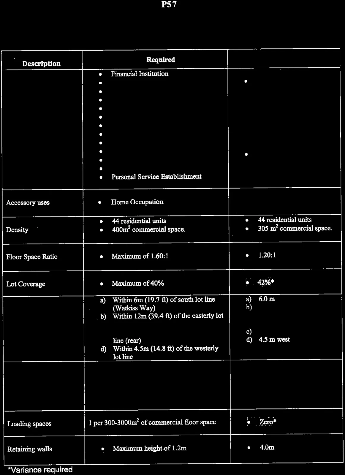
Table 1. Zoning Review
| Description | Required | Proposed |
|---|---|---|
| 11.10 CD-10: Comprehensive Development (Burnside Corner) (Relative to original overall Burnside Corner Comprehensive Development site) |
a) The maximum number of residential units permitted in Sub-zones CD-10A, CD-10B and CD-10C combined shall not exceed one hundred and eighty-five (185) units. b) The maximum gross floor area for commercial uses within the CD-10 zone shall not exceed $400 \text{ m}^2$ c) The averaging of floor area density throughout Sub-zones CD-10A, CD-10B and CD-10C shall be permitted. d) The determination of gross floor area shall not include areas of unenclosed sundecks or balconies, underground parking or the first $45\text{m}^2$ of floor area allocated to above-ground garages or carports used for vehicle parking. |
a) 2151 Burnside Rd W: 21 1900 Watkiss Way: 68 Subject property: 44 Total units: 133 b) $305 \text{ m}^2$ c) 2151 Burnside Rd W: $3710 \text{ m}^2$ 1900 Watkiss Way: $6782 \text{ m}^2$ Subject property: $4062 \text{ m}^2$ Total GFA: $14554 \text{ m}^2$ 2151 Burnside Rd W: $5280 \text{ m}^2$ 1900 Watkiss Way: $7010 \text{ m}^2$ Subject property: $3380 \text{ m}^2$ Total lot area: $15670 \text{ m}^2$ Total overall FSR = 0.93:1 d) Noted |
| e) Mixed commercial / residential or assisted living buildings may not exceed a height of four storeys. f) Buildings with a maximum height of 4 storeys shall not exceed 16m in height. g) Underground parking, 900mm or more below grade, shall not be considered a building storey. h) All commercial uses shall be limited to the first storey of the building. i) The hours of operation for any commercial use shall not exceed 7:00 a.m. to 10:00 p.m. |
e) Subject property: four storey mixed commercial / residential building f) Subject property: 13.3 m g) Noted h) Commercial uses limited to the first storey. i) Noted |
|
| 11.10.3 Parking | • The total amount of above-ground parking shall not exceed 35% of the total parking requirements. | 2151 Burnside Rd W: 0 1900 Watkiss Way: 8 Subject property: 28 Combined surface pkg: 56 • 56/(56+102+63)= 26% |
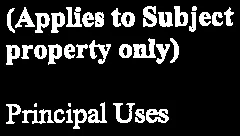
| Sub-Zone CD-10C – Mixed Use Commercial / Residential (Applies to Subject property only) Principal Uses |
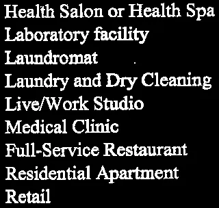
• Financial Institution • Office • Café • Health Salon or Health Spa • Laboratory facility • Laundromat • Laundry and Dry Cleaning • Live/Work Studio • Medical Clinic • Full-Service Restaurant • Residential Apartment • Retail • Personal Service Establishment |
• Office • Residential Apartment |
| Accessory uses | • Home Occupation | |
| Density | • 44 residential units • $400\text{m}^2$ commercial space. |
• 44 residential units • $305 \text{ m}^2$ commercial space. |
| Floor Space Ratio | • Maximum of 1.60:1 | • 1.20:1 |
| Lot Coverage | • Maximum of 40% | • 42%* |
| Setbacks | a) Within 6m (19.7 ft) of south lot line (Watkiss Way) b) Within 12m (39.4 ft) of the easterly lot line (rear) c) Within 2.5m (8.2 ft) of the northerly lot line (rear) d) Within 4.5m (14.8 ft) of the westerly lot line |
a) 6.0 m b) 12.0 m building 6.0 m* solid waste/ recycling enclosure c) 2.5 m d) 4.5 m west |
| Parking | 1.0 per 1BR unit x 29 = 29.0 1.5 per 2BR unit x 15 = 22.5 1 per $25\text{m}^2$ multi-tenant office = 12.2 Total = 65.0 |
1.0 per 1BR unit x 29 = 29.0 1.4 per 2BR unit x 15 = 21.0* 1 per $28\text{m}^2$ m/t office = 11.0* Total = 61.0 |
| Loading spaces | 1 per 300-$3000\text{m}^2$ of commercial floor space | • Zero* |
| Retaining walls | • Maximum height of 1.2m | • 4.0m |
*Variance required
Several variances are requested. The rationale in support of the variances is summarized in Table 2.
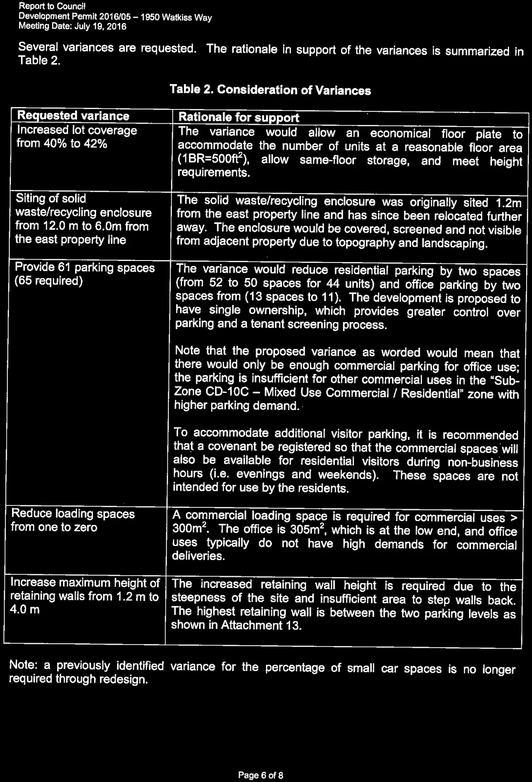
Table 2. Consideration of Variances
| Requested variance | Rationale for support |
|---|---|
| Increased lot coverage from 40% to 42% | The variance would allow an economical floor plate to accommodate the number of units at a reasonable floor area ($1\text{BR}=500\text{ft}^2$), allow same-floor storage, and meet height requirements. |
| Siting of solid waste/recycling enclosure from 12.0 m to 6.0m from the east property line | The solid waste/recycling enclosure was originally sited 1.2m from the east property line and has since been relocated further away. The enclosure would be covered, screened and not visible from adjacent property due to topography and landscaping. |
| Provide 61 parking spaces (65 required) | The variance would reduce residential parking by two spaces (from 52 to 50 spaces for 44 units) and office parking by two spaces from (13 spaces to 11). The development is proposed to have single ownership, which provides greater control over parking and a tenant screening process. Note that the proposed variance as worded would mean that there would only be enough commercial parking for office use; the parking is insufficient for other commercial uses in the “Sub-Zone CD-10C – Mixed Use Commercial / Residential” zone with higher parking demand. To accommodate additional visitor parking, it is recommended that a covenant be registered so that the commercial spaces will also be available for residential visitors during non-business hours (i.e. evenings and weekends). These spaces are not intended for use by the residents. |
| Reduce loading spaces from one to zero | A commercial loading space is required for commercial uses > $300\text{m}^2$. The office is $305\text{m}^2$, which is at the low end, and office uses typically do not have high demands for commercial deliveries. |
| Increase maximum height of retaining walls from 1.2 m to 4.0 m | The increased retaining wall height is required due to the steepness of the site and insufficient area to step walls back. The highest retaining wall is between the two parking levels as shown in Attachment 13. |
Note: a previously identified variance for the percentage of small car spaces is no longer required through redesign.
ATTACHMENTS:
- Property Location Map
- Letter from Nicolas and Sophie Denux, Denfor Investments – May 6, 2016 (4 pages)
- Site Particulars and Project Data – D-Architecture, March 7, 2016 (2 pages)
- A0.1 – Average Grade – D-Architecture, July 6, 2016
- A0.2 – Finished Grade – D-Architecture, July 6, 2016
- A1.0 – Commercial/Parking Floor Plan – D-Architecture, July 7, 2016
- A1.1 – Main Floor Plan – D-Architecture, July 7, 2016
- A1.2 – Second Floor Plan – D-Architecture, April 28, 2016
- A1.3 – Third Floor Plan – D-Architecture, April 28, 2016
- A1.4 – Roof Plan – D-Architecture, July 7, 2016
- A2.1 – Preliminary Elevations – D-Architecture, June 1, 2016
- A3.1 – Preliminary Sections – D-Architecture, April 28, 2016
- A4.1 – Rendering – D-Architecture, June 1, 2016
- A4.2 – Rendering – D-Architecture, June 1, 2016
- 301101 Servicing Plan General Notes – Westbrook Consulting Ltd., July 8, 2016
- 301102 Servicing Plan (Grades) – Westbrook Consulting Ltd., July 8, 2016
- DP-E1 – Parking/Commercial electrical layout – RB Engineering Ltd. July 2016
- DP-E2 – Main Floor electrical layout – RB Engineering Ltd. July 2016
- Landscape Plan - JPH Consultants Inc., April 11, 2016
- Tree Protection Plan – Michael Gye Urban Forestry ltd., July 12, 2016 (7 pages)
- Bicycle Security Systems & Bike Racks - Dobra Design, July 8, 2016
- Project Sustainability Checklist (8 pages)
- Development Permit Guideline Review, Town of View Royal Development Services (7 pages)
Document Images
(18)