STAFF REPORT: Development Variance Permit No. 2016/05 – 275 Kerwood St – Floor Area Variance
Planner report recommending approval of a floor area variance for a new detached dwelling at 275 Kerwood St, subject to lot consolidation.
TOWN OF VIEW ROYAL COUNCIL REPORT
TO: Council DATE: June 1, 2016 FROM: J. Davison, MCIP RPP Planner MEETING DATE: June 7, 2016 FILE NO.: 3090-20-2016/05
DEVELOPMENT VARIANCE PERMIT
275 Kerwood St – Floor Area Variance
RECOMMENDATION
THAT Council approve a variance to the maximum floor area permitted within the R-1: Detached Residential (Large Lot) zone from 372m² to 434m² as per the plans attached to the report from the Planner dated June 1, 2016.
AND THAT a condition of Development Variance Permit 2016/05 be that the subject lots (Lot 1 and Lot 1A, Block 12, Section 27, Esquimalt District, Plan 1688) be consolidated into one lot.
CHIEF ADMINISTRATIVE OFFICER'S COMMENTS
I concur with the recommendation.
DIRECTOR OF DEVELOPMENT SERVICES' COMMENTS
I concur with the recommendation.
PURPOSE OF REPORT
The purpose of this report is to present the application for a Development Variance Permit (DVP) to vary the floor area from 372m² to 434m² for a new detached dwelling which is proposed at 275 Kerwood St under an R-1: Detached Residential (Large Lot) zoning.
BACKGROUND
The property addressed as 275 Kerwood St is comprised of two lots – Lot 1 and Lot 1A, Block 12, Section 27, Esquimalt District, Plan 1688. Separately the lots are 748m² (Lot 1-A) and 808m² (Lot 1) which are under-sized and lawfully non-conforming within the R-1 zone, yet consistent with the other narrow lots on that segment of Kerwood St. Together they measure 1556m².
The previous house has been removed.
The property has existing structures within the Natural Watercourse and Shoreline Environmental Development Permit Area, parts of which straddle the uplands property and which will likely undergo some future works requiring an Environmental Development Permit including (as staff understands) a dock, and works to address some slope stability issues on-site. The building within the foreshore is entirely within the foreshore and off-site.
The photo below illustrates the foreshore structures as they appear from the water:
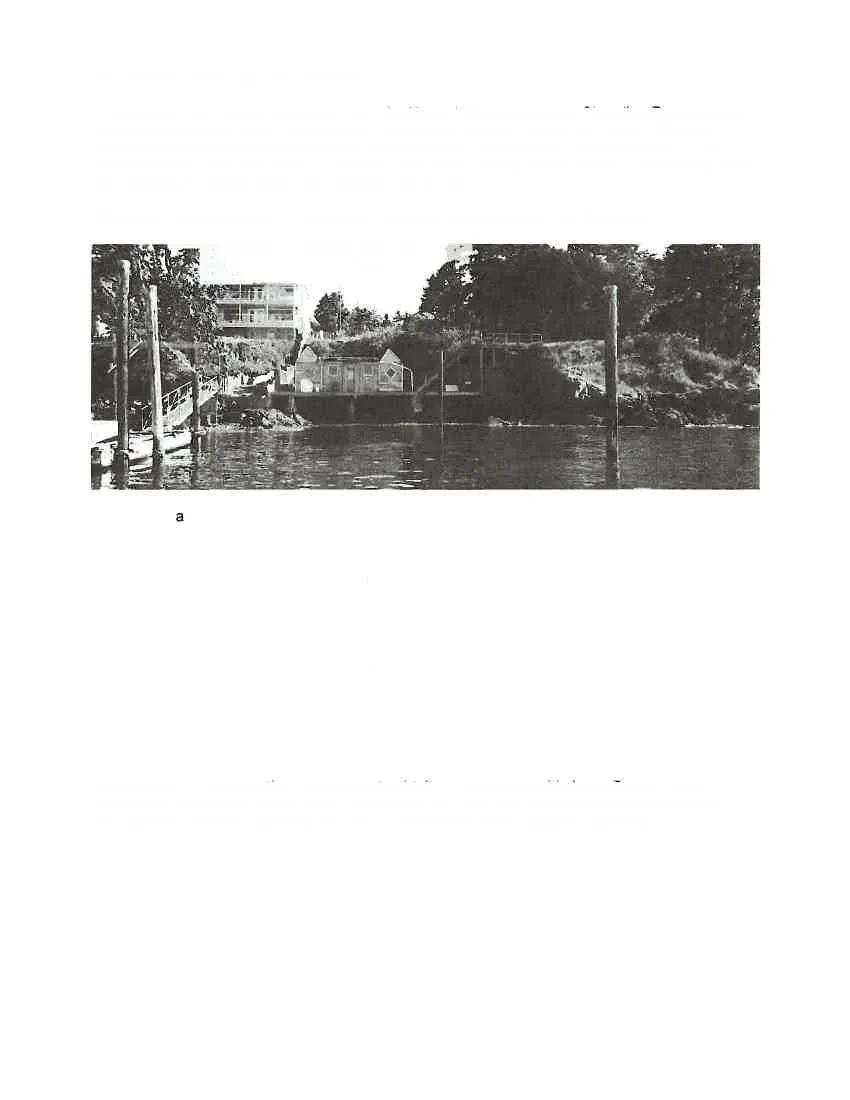
Council has a limited ability to fully address the foreshore structures with the Development Variance Permit or the Development Permit process, as they are existing and lawfully non-conforming in nature. They are permitted to remain in the foreshore as per an existing License of Occupation issued by CFB Esquimalt. The structures can be repaired to the existing dimensions without a Development Permit.
As part of a future dock application or slope stability/retaining wall construction process requiring a Development Permit, Council can require shoreline enhancement as it pertains to environmental protection relating to the application, and speak to the proposal as it pertains to the Private Dock Development Guidelines.
PROJECT INFORMATION
Proposal
The property is subject to the requirement to obtain a Development Variance Permit (DVP) pursuant to Section 922 of the Local Government Act. This DVP focuses on the consideration of the proposed variance impacting the use and enjoyment of the adjacent properties.
The applicant has submitted the following information in support of their application:
- Applicant’s statement – Owners – April 18, 2016
- Heritage Conservation Act Site Alteration Permit 2015-0162 – Tal Fisher, C.D. (Archaeologist), Permitting and Assessment Section, Ministry of Forests, Lands and Natural Resource Operations, Archaeology Branch – April 22, 2016
- Environmental Overview – Fish Kissing Weasels Environmental – 19 April 2016
- Site Survey – Island Land Surveying Ltd – January 14, 2015
- Site Plan (existing vs proposed) – Island Land Surveying Ltd – February 24, 2016
- Plans and Elevations – Consultant – April 19, 2016
The proposed Development Variance Permit addresses the following aspects:
- Variance to the maximum permitted floor area of 372m² to 434m²
It should be noted that the structures in the foreshore are not on the property itself and as such do not count towards the floor area of the property.
Issues and Analysis
The decision before Council is whether the variance to permit the additional floor area will affect the use and enjoyment of adjacent properties, and whether the application offers a net improvement to the property and to the neighbourhood.
A condition of the Development Variance Permit is the requirement for a lot consolidation to join the two lots into one. Should the variance for floor area not be granted, the applicants wish to retain the option to build two houses on two lots.
As can be seen in the drawing in the attachments which shows the old house’s footprint in comparison with the new house’s footprint, the new house covers more of the lot than the previous. Conversely, the proposed house is pulled back closer to the street. Unlike the previous house, it is not within the 15m setback to the natural boundary of the sea (and the Environmental Development Permit Area).
The proposed house is a slope-adaptive design that is two stories at the front and a three-tiered design at the back, with two decks. A significant portion of the floor area is below grade as basement. The building floor area breaks down such:
- Basement: 92.34m²
- Main Floor: 197.73m²
- Second Floor: 142.95m²
The requested floor area is 434m², and the maximum permitted in the zone is 372m². Note that the drawings include the carport as floor area; our Zoning Bylaw does not.
The proposed FSR (Floor Space Ratio) on the site is 0.28. The maximum permitted in the zone is 0.42.
Staff is of the opinion that the variance to the floor area of the house is reasonable considering the design of the house and the size of the lot.
RECOMMENDATION
THAT Council approve a variance to the maximum floor area permitted within the R-1: Detached Residential (Large Lot) zone from 372m² to 434m² as per the plans attached to the report from the Planner dated June 1, 2016.
AND THAT a condition of Development Variance Permit 2016/05 be that the subject lots (Lot 1 and Lot 1A, Block 12, Section 27, Esquimalt District, Plan 1688) be consolidated into one lot.
ATTACHMENTS:
- Subject Property Map
- Subject Property Orthophoto
- Applicant’s Statement with photos – April 18, 2016
- Heritage Conservation Act Site Alteration Permit 2015-0162 – Tal Fisher, C.D. (Archaeologist), Permitting and Assessment Section, Ministry of Forests, Lands and Natural Resource Operations, Archaeology Branch – April 22, 2016
- Environmental Overview – Fish Kissing Weasels Environmental – 19 April 2016
- Site Survey – Island Land Surveying Ltd – January 14, 2015
- Site Plan (existing vs proposed) – Island Land Surveying Ltd – February 24, 2016
- Plans and Elevations – Consultant – April 19, 2016
Document Images
(11)