346 ISLAND HIGHWAY Traffic Impact Assessment
A detailed traffic impact assessment conducted by Watt Consulting Group for a proposed 94-unit multi-family residential development at 346 Island Highway.
346 ISLAND HIGHWAY
Traffic Impact Assessment
MJ Oh – Transportation Technologist, Author Kristen Machina, P.Eng. – Senior Transportation Engineer, Reviewer
Prepared For: GT Mann Contracting Ltd. Date: March 13, 2024 Our File No: 3453.B01
WATT VICTORIA #302, 740 Hillside Avenue Victoria, BC V8T 1Z4 (250) 388-9877
WATTCONSULTINGGROUP.COM
1.0 INTRODUCTION
Watt Consulting Group was retained by GT Mann Contracting Ltd. to conduct a traffic impact assessment for a proposed multi-family residential development at 346 Island Highway in the Town of View Royal. This study assesses traffic impacts of the proposed multi-family residential building, reviews the site access, and assesses the need for any mitigation measures. The study reviews the existing traffic operations along with the post development conditions for all modes of transportation. The study follows the Town’s TAMS guidelines (Level 1).
1.1 STUDY AREA
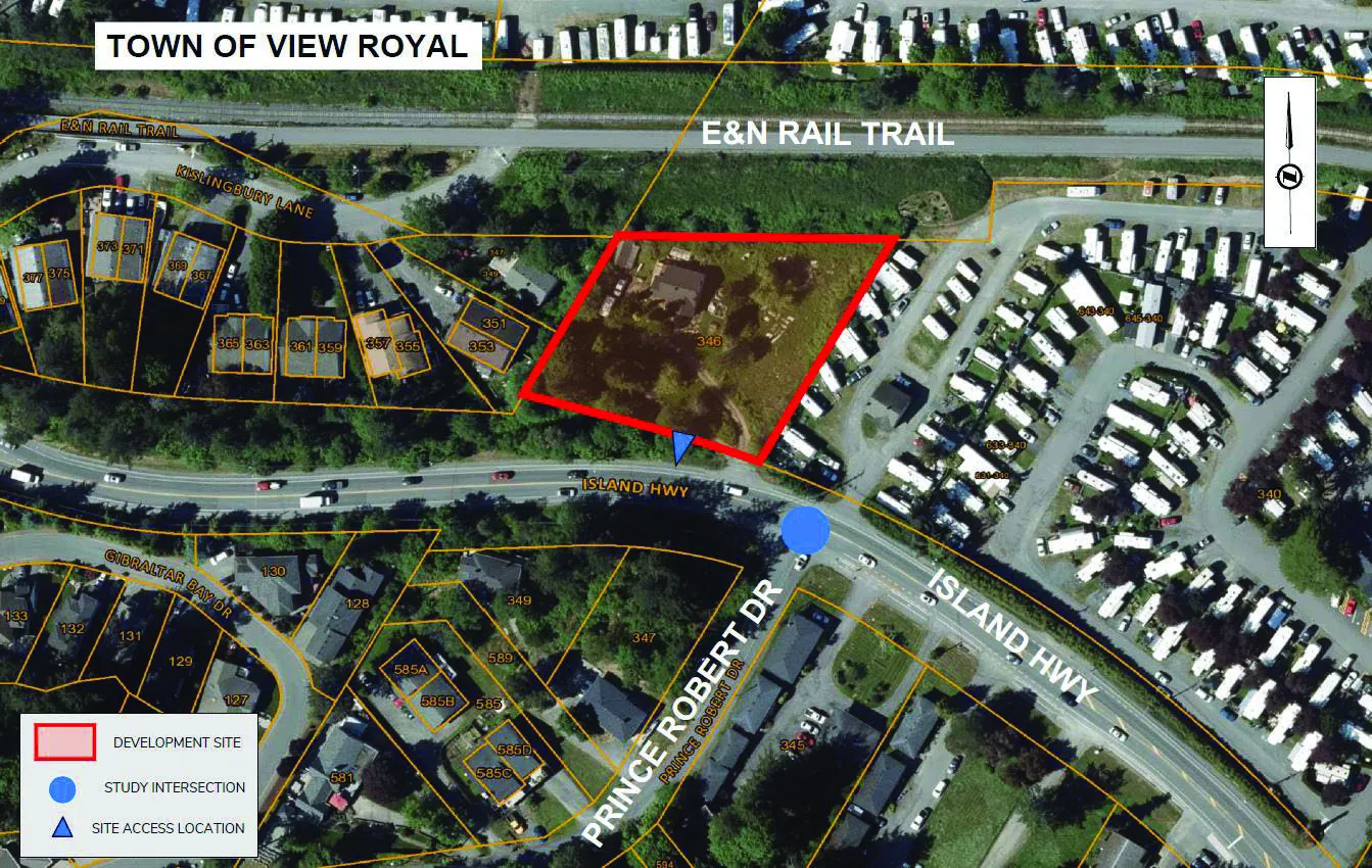
See Figure 1 for the study area and location. The study area includes the site access and the intersection of Island Highway / Prince Robert Drive.
2.0 EXISTING CONDITIONS
2.1 LAND USE
The proposed development site is a single-family residential lot (346 Island Highway). The surrounding area of the development is mostly residential along Island Highway and Prince Robert Drive. To the east, there is the Fort Victoria RV Park north of Island Highway. The E&N Rail Trail passes through immediately north of the development site.
2.2 ROAD NETWORK
The proposed development is located on the north side of Island Highway close to the Island Highway / Prince Robert Drive intersection. Island Highway is under the jurisdiction of the Ministry of Transportation and Infrastructure. Prince Robert Drive is under the jurisdiction of the Town of View Royal. All roads within the study area have a maximum speed limit of 50 km/h. A description of all relevant roads in the area is provided below.
Island Highway is a two-lane highway with a functional classification as a Major Road. There are many private property accesses present, and the turning movements associated with them cause conflict and delay along the corridor. There are bike lanes on both sides, but limited sidewalks along most of the roadway (new sidewalk has been installed along the View Royal Fire Department frontage).
Prince Robert Drive is a two-lane local road connected to Island Highway adjacent to the development site. There is no sidewalk and limited shoulders provided along the roadway.
The intersection of Island Highway / Prince Robert Drive is stop-controlled with no separate turn lanes. Sight distance for northbound left turning traffic (looking to the left along the highway) from Prince Robert Drive is limited due to the horizontal curvature and vegetation. It is expected that the intersection improvements be implemented including a westbound left turn lane on Island Highway at Prince Robert Drive when development of the adjacent property (345 Island Highway) proceeds.
2.3 TRAFFIC VOLUMES
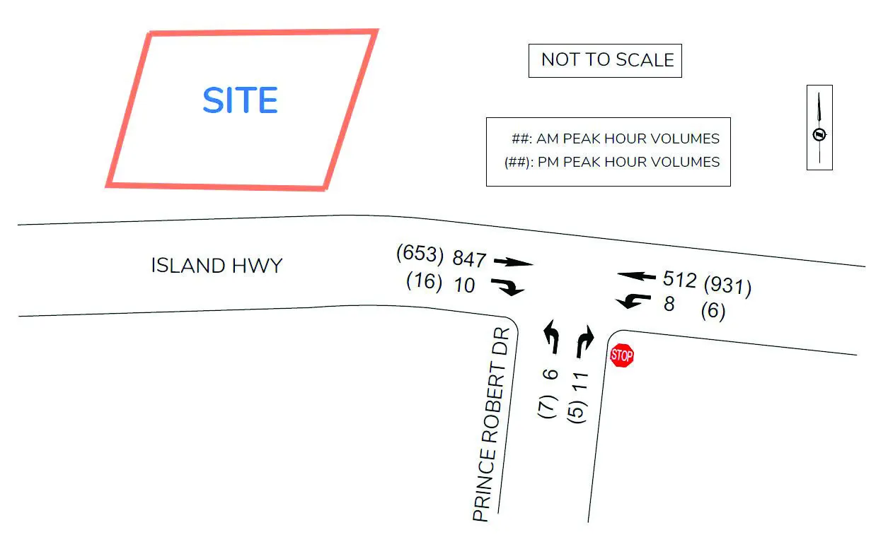
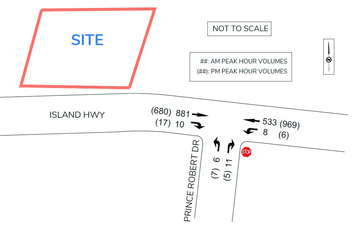
Traffic counts were undertaken during the AM and PM peak hours on Tuesday November 15, 2022, at the key intersection of Island Highway / Prince Robert Drive. There was a prior count available for the intersection, which was measured in April 2021. The 2022 counts were compared to the 2021 counts that were undertaken during the COVID-19 pandemic, results showed that the 2022 measured volumes are 7.9 % higher on average for the AM / PM peak hours than the 2021 volumes. The 2022 measured volumes are considered as the normal level before the COVID-19 pandemic. 2022 measured volumes were used for the existing conditions analysis without applying a scaling factor due to the pandemic. However, turning volumes at the side streets were chosen with higher values of 2021 and 2022 counts for a conservative analysis. For the intersection of Island Highway / Prince Robert Drive, existing volumes (three approaches total) were measured at 1,396 vehicles for the AM peak hour and 1,620 vehicles for the PM peak. Figure 2 shows the existing volumes used in this study.
2.4 TRAFFIC MODELLING – BACKGROUND INFORMATION
Analysis of the traffic conditions at the intersections within the study area were undertaken using Synchro traffic analysis software.
Synchro / SimTraffic is a two-part traffic modelling software that provides analysis of traffic conditions based on traffic-control, geometry, volumes, and traffic operations. Synchro software (Synchro 9/10) provides analysis using the Highway Capacity Manual (2010) methodology, while SimTraffic integrates established driver behaviors and characteristics to simulate actual conditions by randomly “seeding” vehicles travelling throughout the network. Outputs of the Synchro software include Level Of Service (LOS), delay (seconds per vehicle), and 95th percentile queue length (in vehicles, assuming 7.5m per vehicle).
LOS is broken down into six letter grades, with LOS A being excellent operations, and LOS F being unstable / failure operations. LOS C is generally considered to be an acceptable LOS by most municipalities. LOS D is generally considered to be on the threshold between acceptable and unacceptable operations. A description of LOS and Synchro is provided in Appendix A.
Volume-to-Capacity ratios are also considered in assessing the roadway network or determining required traffic control improvements. According to the city’s guidelines, for individual movements, the minimum acceptable V/C ratio is 0.95 used as a general threshold for mitigation.
2.5 EXISTING TRAFFIC CONDITIONS
The existing traffic conditions were analyzed at the intersection of Island Highway / Prince Robert Drive. While Synchro results for the study intersection generally show good performance along Island Highway (LOS A and B), field observations indicate that there is congestion along the corridor due to delays at signalized intersections downstream from Prince Robert Drive, particularly in the eastbound direction during the AM peak hour.
At Island Highway / Prince Robert Drive, the stop-controlled northbound movement operates at LOS D in the AM / PM peak hour while movements along Island Highway operate at LOS A/B. The westbound left 95th percentile queue length was estimated at 12 to 14m during the AM / PM peak hour. It was observed that the eastbound through traffic (moving slow due to congestion) on Island Highway mostly stopped to yield to westbound left turn vehicles at Prince Robert Drive in the AM peak hour. See Table 1 for the results of the existing conditions analysis.
TABLE 1: EXISTING CONDITIONS
| INTERSECTION | MOVEMENT | AM Peak Hour LOS | AM Peak Hour Delay (s) | AM Peak Hour v/c Ratio | AM Peak Hour Queue (m)* | PM Peak Hour LOS | PM Peak Hour Delay (s) | PM Peak Hour v/c Ratio | PM Peak Hour Queue (m)* |
|---|---|---|---|---|---|---|---|---|---|
| ISLAND HWY / PRINCE ROBERT DR (EB/WB=ISLAND HWY) | EBTR | A | 0.0 | - | 2.3 | A | 0.0 | - | 3.8 |
| WBLT | B | 10.3 | 0.02 | 12.1 | A | 9.1 | 0.01 | 13.7 | |
| NBLR | D | 29.8 | 0.16 | 11.1 | D | 31.6 | 0.15 | 9.8 |
*Note: 95th Queues based on SimTraffic results (averaged from five simulation runs)
3.0 POST DEVELOPMENT
3.1 PROPOSED LAND USE
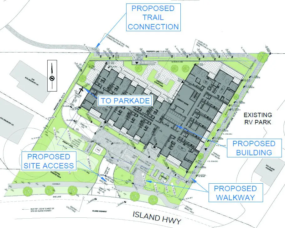
The proposed development is a multi-family residential building (mid-rise) with 94 dwelling units. See Figure 3 for the site plan and access.
3.2 SITE ACCESS
For the new development, a site access is proposed on Island Highway 45m west of Prince Robert Drive. The proposed access location satisfies the Transportation Association of Canada (TAC) suggested minimum corner clearance (25m) to an access at stop-controlled major intersections for collector roads.
3.3 TRIP GENERATION
Trip generation rates were estimated using the 11th Edition of the ITE Trip Generation Manual. Trip generation rates for the weekday AM and PM peak hours are shown in Table 2.
Table 3 shows the estimated trips generated by the proposed development of multi-family residential use (mid-rise building). The development is expected to generate a net 35 weekday AM peak hour trips, and 37 weekday PM peak hour trips. These estimated vehicle trips are considered conservative, as the existing site trips were not deducted from the opening day background volumes.
TABLE 2: PEAK HOUR TRIP GENERATION RATES
| ITE Land Use Code | ITE Land Use Description | Weekday AM Rate | Weekday AM In | Weekday AM Out | Weekday PM Rate | Weekday PM In | Weekday PM Out |
|---|---|---|---|---|---|---|---|
| 221 | Multi-Family Housing (Mid-Rise) | 0.37 | 23% | 77% | 0.39 | 61% | 39% |
TABLE 3: ESTIMATED DEVELOPMENT TRIPS
| Description | Units | Weekday AM In | Weekday AM Out | Weekday AM Total | Weekday PM In | Weekday PM Out | Weekday PM Total |
|---|---|---|---|---|---|---|---|
| Multi-family (Mid-Rise) | 94 | 8 | 27 | 35 | 23 | 14 | 37 |
3.4 TRIP ASSIGNMENT
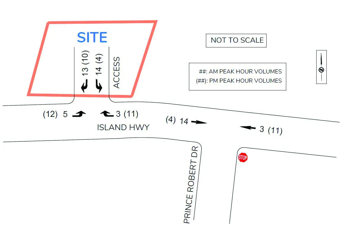
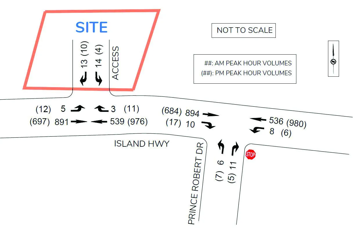
The trip assignment was based on existing traffic patterns in the area and the 2017 CRD Origin Destination Household Travel Survey. Table 4 summarizes the distribution percentages of the site trips at the study intersection and site access, while trip assignments are shown in Figure 4.
TABLE 4: DISTRIBUTION PERCENTAGES OF SITE TRIPS
| AM Peak Hour | PM Peak Hour |
|---|---|
| • 50% of trips to Island Hwy East | • 30% of trips to Island Hwy East |
| • 50% of trips to Island Hwy West | • 70% of trips to Island Hwy West |
| • 35% of trips from Island Hwy East | • 50% of trips from Island Hwy East |
| • 65% of trips from Island Hwy West | • 50% of trips from Island Hwy West |
3.5 2026 OPENING DAY BACKGROUND CONDITIONS
It is assumed that the opening day is in 2026. 2026 base volumes were projected using a 1.0% annual growth rate scaled up from the 2022 volumes. 2026 background conditions for the opening day were analyzed for the key intersection based on the estimated 2026 volumes and current traffic control / laning.
At Island Highway / Prince Robert Drive, the stop-controlled northbound movement will continue to operate at LOS D in the AM / PM peak hour. The westbound left queues on Island Highway will slightly increase to 13m / 16m in the AM / PM peak hour. See Table 5 for the results of the analysis. See Figure 5 for 2026 opening day background volumes.
TABLE 5: 2026 OPENING DAY BACKGROUND CONDITIONS
| INTERSECTION | MOVEMENT | AM Peak Hour LOS | AM Peak Hour Delay (s) | AM Peak Hour v/c Ratio | AM Peak Hour Queue (m)* | PM Peak Hour LOS | PM Peak Hour Delay (s) | PM Peak Hour v/c Ratio | PM Peak Hour Queue (m)* |
|---|---|---|---|---|---|---|---|---|---|
| ISLAND HWY / PRINCE ROBERT DR (EB/WB=ISLAND HWY) | EBTR | A | 0.0 | - | 3.3 | A | 0.0 | - | 4.9 |
| WBLT | B | 10.4 | 0.02 | 12.8 | A | 9.2 | 0.01 | 15.8 | |
| NBLR | D | 32.4 | 0.18 | 12.3 | D | 34.4 | 0.16 | 9.8 |
*Note: 95th Queues based on SimTraffic results (averaged from five simulation runs)
3.6 OPENING DAY POST DEVELOPMENT CONDITIONS
The 2026 opening day post-development conditions were analyzed by adding the development trips to background traffic volumes.
The proposed development will have little impact on traffic operations at the intersection of Island Highway / Prince Robert Drive. At the intersection, the northbound movement drops to LOS E from LOS D with an additional delay of less than a second in the PM peak hour while continues to operate at LOS D in the AM peak hour. The Island Highway eastbound and westbound movements continue to operate at LOS A/B with additional delays of 0.1 seconds in the AM and PM peak hours. The westbound left queues were estimated at 19m / 11m in the AM and PM peak hours, which slightly increase compared to the background conditions.
At Island Highway / Site Access, the stop controlled southbound movement operates at LOS D in the AM and PM peak hours with development. The eastbound left turn movement operates at LOS A/B in the peak hours. The eastbound left queues were estimated at 10m / 18m on Island Highway at the site access during the AM / PM peak hour. A left turn lane warrant review for the site access is described in Section 4.2.
See Table 6 for the results of the analysis. See Figure 6 for the Opening Day post development volumes.
TABLE 6: 2026 OPENING DAY POST DEVELOPMENT CONDITIONS
| INTERSECTION | MOVEMENT | AM Peak Hour LOS | AM Peak Hour Delay (s) | AM Peak Hour v/c Ratio | AM Peak Hour Queue (m)* | PM Peak Hour LOS | PM Peak Hour Delay (s) | PM Peak Hour v/c Ratio | PM Peak Hour Queue (m)* |
|---|---|---|---|---|---|---|---|---|---|
| ISLAND HWY / PRINCE ROBERT DR (EB/WB=ISLAND HWY) | EBTR | A | 0.0 | - | 8.4 | A | 0.0 | - | 7.6 |
| WBLT | B | 10.5 | 0.02 | 19.1 | A | 9.3 | 0.01 | 10.9 | |
| NBLR | D | 33.0 | 0.18 | 9.8 | E | 35.2 | 0.17 | 8.8 | |
| ISLAND HWY / SITE ACCESS (EB/WB=ISLAND HWY) | EBLT | A | 8.8 | 0.01 | 10.2 | B | 10.5 | 0.02 | 18.0 |
| WBTR | A | 0.0 | - | 1.8 | A | 0.0 | - | - | |
| SBLR | D | 28.9 | 0.18 | 15.4 | D | 33.6 | 0.14 | 10.8 |
*Note: 95th Queues based on SimTraffic results (averaged from five simulation runs)
4.0 SAFETY AND GEOMETRICS
4.1 SIGHT DISTANCE
At the proposed site access location, measured sight distances (> 150m for both directions) exceeds the TAC’s required intersection sight distances (105m) for left / right turn from stop on a 50 km/h, two lane road. Therefore, the proposed site access is properly located from a safety perspective.
4.2 LEFT TURN LANE WARRANT REVIEW
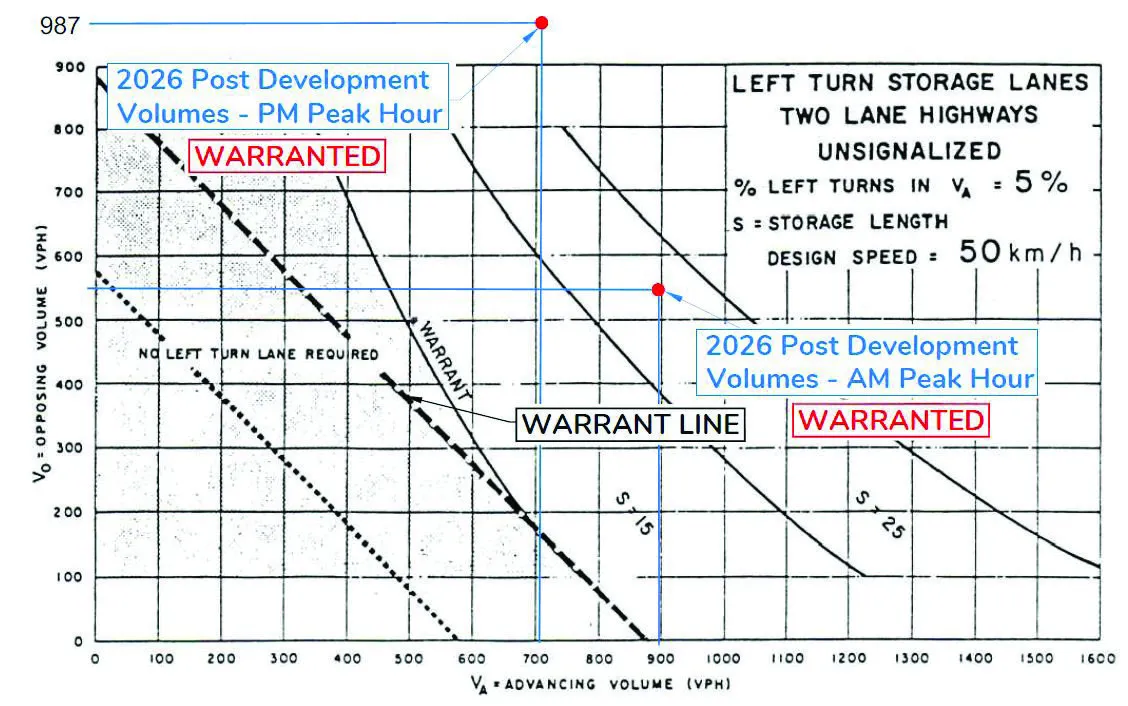
Based on the 2026 AM / PM post development volumes, an eastbound left turn lane is warranted at the site access due to high through volumes on Island Highway. While eastbound left turn movements only represent approximately 2% of eastbound traffic, a minimum 5% left turn ratio was assumed for the purposes of the BC MoTI Warrant. See Figure 7 for the left turn lane warrant review.
A 25m eastbound left turn lane is required based on the 2026 post development peak hour volumes. A two-way centre left turn lane could also be implemented along Island Highway from the site access to the Prince Robert Drive intersection to give the RV park an improved opportunity to turn into the property.
5.0 ACTIVE TRANSPORTATION
5.1 PEDESTRIANS AND CYCLING FACILITIES
The E&N Rail Trail provides capacity for pedestrian and cycle traffic, and runs through just north of the development site. According to the site plan, a walkway is proposed along the east and north sides of the development, which provides a direct connection to the E&N Rail Trail from the site. The proposed walkway also provides a connection to existing sidewalk of the development frontage. There are asphalt sidewalks (1.2m wide) with barriers on both sides of Island Highway adjacent to the development. According to the View Royal TMP, a 2.0m sidewalk with landscaped boulevards is recommended along the development frontage of Island Highway. A new concrete sidewalk with boulevards would be installed when the Island Highway / Prince Robert Drive intersection is improved with the adjacent new development at 346 Island Highway.
Island Highway is designated as a commuter cycling route. There are bike lanes provided along both sides of Island Highway. If a left turn lane is installed on Island Highway the bike lanes should be preserved. According to the TMP, a 1.8m bike lane is recommended along the development frontage of Island Highway.
5.2 TRANSIT
The bus route No. 46 passes in front of the proposed site on Island Highway providing service from Langford (Westhills Exchange) to Esquimalt (HMC Dockyard) via the Colwood Exchange two times per peak hours on weekdays. Currently, there are bus stops on both sides of Island Highway 85m east of the site access. The existing bus stops are expected to improve with shelters / pull-outs when redevelopments (RV Park and 345 Island Highway sites) occur in the adjacent area.
6.0 CONCLUSION
The proposed development will generate 35 vehicle trips in the AM peak hour and 37 vehicle trips in the PM peak hour. The development will have little impact on the traffic operations at the adjacent intersection of Island Highway / Prince Robert Drive, as the development adds only a small amount of through volume on Island Highway. The development will not substantially change levels of service for all movements at the intersection as additional delays are minor with less than one second for any movement. At Island Highway / Prince Robert Drive, the stop controlled northbound left turn movement will operate at LOS D / E in the AM / PM peak hour with the development.
The proposed site access on Island Highway satisfies TAC’s sight distance requirements for turns from stop and recommended spacing (clearance distance) from unsignalized major intersections. However, an eastbound left turn lane is warranted on Island Highway at the site access due to high through volumes (despite the forecasted left turn volumes being relatively low). Implementing an eastbound left turn lane should be considered when the Island Highway / Prince Robert Drive is upgraded with a westbound left turn lane. Additionally, this left turn lane could be extended to the Prince Robert Drive left turn lane (for the left turn traffic at RV Park) using a two-way centre left turn lane.
The development provides a pathway connection from the site to the E&N Rail Trail, which will promote pedestrian / cyclist activities. A new 2.0m wide sidewalk with boulevards would be installed along the development frontage as per the Town’s TMP. If a left turn lane is installed on Island Highway at the access, the bike lanes should be preserved. A 1.8m bike lane is recommended along the development frontage of Island Highway. On Island Highway, the existing bus stops are located 85m east of the development.
7.0 RECOMMENDED IMPROVEMENTS
The following improvements are recommended of the developer:
- Install a sidewalk with landscaped boulevards along the development frontage of Island Highway.
- Preserve the westbound bike lane with barrier on Island Highway with a paved shoulder along the development frontage if an eastbound left turn lane be implemented at the site access.
The following improvements are recommended of the Town of View Royal:
- Install a 25m eastbound left turn lane on Island Highway at the site access and convert the painted median on Island Highway into a TWLTL until Prince Robert Drive - RV Park access.
APPENDICES
APPENDIX A: SYNCHRO INFORMATION
SYNCHRO MODELLING SOFTWARE DESCRIPTION
The traffic analysis was completed using Synchro and SimTraffic traffic modeling software. Results were measured in delay, level of service (LOS) and 95th percentile queue length. Synchro is based on the Highway Capacity Manual (HCM) methodology. SimTraffic integrates established driver behaviours and characteristics to simulate actual conditions by randomly “seeding” or positioning vehicles travelling throughout the network. The simulation is run five times (five different random seedings of vehicle types, behaviours and arrivals) to obtain statistical significance of the results.
Levels of Service
Traffic operations are typically described in terms of levels of service, which rates the amount of delay per vehicle for each movement and the entire intersection. Levels of service range from LOS A (representing best operations) to LOS E/F (LOS E being poor operations and LOS F being unpredictable / disruptive operations). LOS E/F are generally unacceptable levels of service under normal everyday conditions.
The hierarchy of criteria for grading an intersection or movement not only includes delay times, but also takes into account traffic control type (stop signs or traffic signal). For example, if a vehicle is delayed for 19 seconds at an unsignalized intersection, it is considered to have an average operation, and would therefore be graded as an LOS C. However, at a signalized intersection, a 19 second delay would be considered a good operation and therefore it would be given an LOS B. The table below indicates the range of delay for LOS for signalized and unsignalized intersections.
Table A1: LOS Criteria, by Intersection Traffic Control
| Level of Service | Unsignalized Intersection Average Vehicle Delay (sec/veh) | Signalized Intersection Average Vehicle Delay (sec/veh) |
|---|---|---|
| A | Less than 10 | Less than 10 |
| B | 10 to 15 | 11 to 20 |
| C | 15 to 25 | 20 to 35 |
| D | 25 to 35 | 35 to 55 |
| E | 35 to 50 | 55 to 80 |
| F | More than 50 | More than 80 |
Document Images
(3)