REZONING APPLICATION 2022-06 – 14, 14A HELMCKEN ROAD & 6 CAMDEN AVENUE
A planning report regarding the rezoning of three properties to allow for the construction of a three-storey, 27-unit residential strata building.
TOWN OF VIEW ROYAL
PLANNING, DEVELOPMENT & ENGAGEMENT REPORT
TO: Committee of the Whole DATE: December 12, 2023 FROM: Stirling Scory, RPP, MCIP Community Planner MEETING DATE: January 9, 2024
REZONING APPLICATION 2022-06 – 14, 14A HELMCKEN ROAD & 6 CAMDEN AVENUE
RECOMMENDATION:
THAT the report dated December 12, 2023, from the Community Planner titled “Rezoning Application 2022-06 – 14, 14A Helmcken Road & 6 Camden Avenue” be received for information.
PURPOSE:
To introduce Rezoning Application 2022-06 to rezone the properties located at 14, 14A Helmcken Road and 6 Camden Avenue from R-1B: Detached Residential (Medium Lot) to a new Comprehensive Development zone to allow for a three-storey, multi-unit residential building that would contain approximately twenty-seven strata dwelling units.
TIME CRITICAL:
There are no time critical considerations for the Town.
EXECUTIVE SUMMARY:
The purpose of this application is to rezone the properties located at 14, 14A Helmcken Road and 6 Camden Avenue from R-1B: Detached Residential (Medium Lot) to a new Comprehensive Development zone. The proposed development concept includes a three-storey, multi-unit residential building with a density of 1:37:1 floor space ratio (FSR) and approximately twenty-seven dwelling units (strata).
The proposal complies with the use and density provisions of the Mixed Residential land use designation in the Official Community Plan (OCP); and therefore, an OCP amendment is not required. The development concept includes a mix of one, two, and three-bedroom units, underground residential parking and above ground visitor parking, a roof-top patio and garden, an on-site dog play area, an indoor flex amenity space connected to an outdoor patio, and a pavilion and rain garden feature. The proposal further advances several OCP policies related to family-oriented housing and home ownership opportunities.
BACKGROUND:
The 1,611.6 m² (17,347 ft²) development site is comprised of three properties: 14, 14A Helmcken, and 6 Camden Avenue. Both 14 Helmcken Road and 6 Camden Avenue have existing single detached dwellings though the houses are currently vacant. 14A Helmcken Road is a vacant lot. The development site is designated Mixed Residential in the Official Community Plan (2011) and the properties are zoned R-1B: Detached Residential (Medium Lot).
PROJECT INFORMATION:
The proposal is to rezone the subject properties from the R1-B zone to a new Comprehensive Development (CD) zone to permit a three-storey, multi-unit residential development consisting of approximately twenty-seven dwelling units (strata). The rezoning application addresses zoning regulations for the permitted land use(s), density, building height, setbacks, lot coverage and impermeable surfaces.
Other information in this section describes the applicant’s vision and proposed development concept; however, it should be noted that considerations of form and character and on-site landscaping would be reviewed at the development permit stage, if the rezoning is approved.
Development Concept:
The applicant has provided conceptual renderings for their rezoning application (Attachment 2). The renderings indicate what could be built on the site, should the rezoning be successful. A copy of the conceptual site plan (Figure 1) and conceptual building renderings (Figures 2, 3, 4, and 5) are provided below.
Staff notes the following items with the proposed development concept:
- Units along Helmcken Road would have ground floor entrances that would create a pedestrian-friendly streetscape.
- The proposed design would support community-building and foster social interaction with the inclusion of an outdoor pavilion space complete with a BBQ, chairs, and table.
- The proposed design optimizes the site coverage by locating vehicular parking underground, which allows for more landscaping opportunities and preservation of existing trees.
Figure 1 - Site Plan 14, 14A Helmcken Rd & 6 Camden Ave
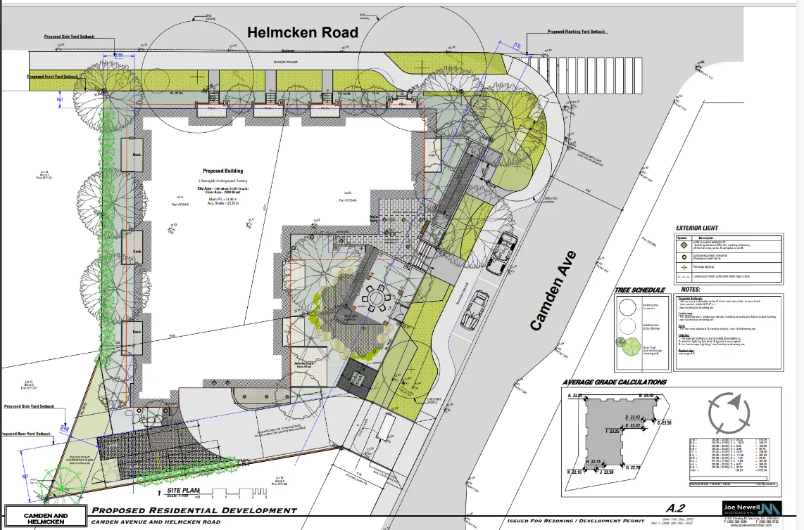
Figure 2 - Conceptual Rendering: Helmcken Road
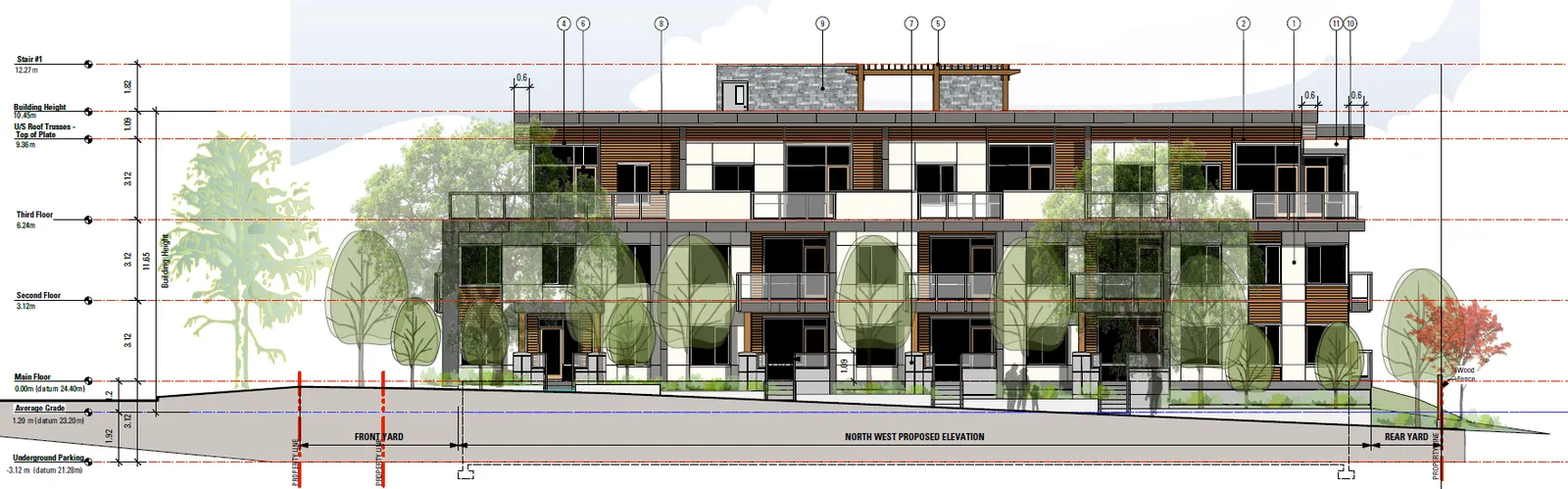
Figure 3 - Conceptual Rendering: Camden Avenue
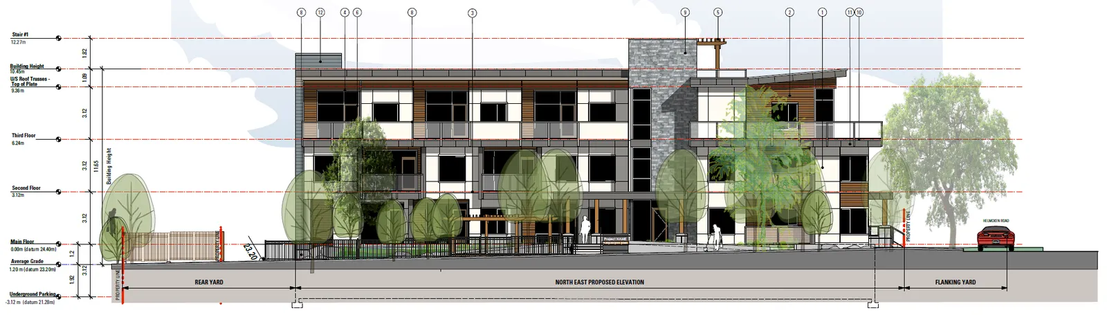
Figure 4 - Conceptual Rendering: Side Yard (South/Conard Street)
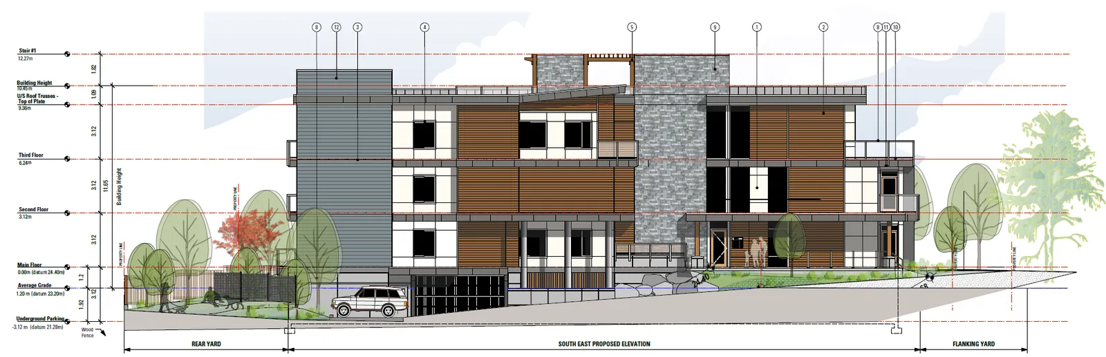
Figure 5 - Conceptual Rendering: Side Yard (West)
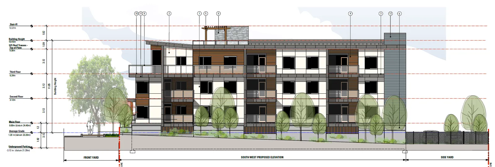
The proposed development includes approximately twenty-seven dwelling units, of which the majority are one- and two-bedroom units. A breakdown of the unit mix is summarized in Table 1 below.
Table 1 - Dwelling Unit Summary
| Unit Type | Number of Units |
|---|---|
| One Bedroom | 14 Units |
| Two Bedroom | 12 Units |
| Three Bedroom | 1 Unit |
The applicant has expressed an interest in providing alternative housing options to single-detached dwellings, with the intent that the proposed units may cater to young professionals working at the hospital who may be interested in homeownership options. The proposal may also be an attractive alternative for retirees and empty nesters who have an existing single-family dwelling and would like to downsize and relieve the burden of having to maintain a single-family dwelling. The proximity of the development site to Eagle Creek Village supports a walkable and accessible neighbourhood that provides incentive to walk and cycle for daily errands instead of relying on vehicles.
DISCUSSION:
Official Community Plan Context
Hospital Neighbourhood Centre
The development site is located within the Hospital Neighbourhood Centre, an identified activity hub that supports established residential areas by providing services, shops, and employment opportunities where people want to live. These centres also allow for more diverse and higher density housing forms. The scale of these developments should be walkable. This proposal supports the vision for Hospital Neighbourhood Centre.
Northern Gateway Community Corridor
The subject site is also located within the Northern Gateway Community Corridor, which is identified as a major transportation corridor that shares a similar role to Neighbourhood Centres. The primary function of the identified corridor is to create centres, destinations, and connections within and between neighbourhoods. The OCP identifies anticipated infill development of higher density within the Northern Gateway Community Corridor, which is expected to revitalize underutilized land. This application proposes low-rise infill residential development that is compatible with this vision and the neighbourhood context.
Land Use Designations
The site is designated Mixed-Residential (MR) in the Official Community Plan (OCP) Land Use Designation Map, which supports the following:
- Small Lot Detached Houses, Townhouses and Low-Rise Apartments a. Up to 3 Storeys/1.25 FSR Permitted b. 4 Storeys/1.6 FSR Permitted for Apartment Dwellings
The proposed land use, height, and density are consistent with the Mixed Residential OCP land use designation; and therefore, an amendment to the Official Community Plan is not required.
Policy Summary
The proposal further advances policies within the OCP, which may be reviewed in Attachment 9. Those considered significant are summarized below:
Policy LU1.1 Neighbourhood Centres Create a network of neighbourhood-serving, mixed-use centres. Encourage the majority of new and infill residential and commercial growth into these areas to create compact, walkable and cycling-friendly activity hubs.
Policy LU1.2 Connected Centres Ensure that residential densities at neighbourhood centres increase the viability of transit, bike and pedestrian travel modes.
Policy LU1.4 Diversity of Forms and Uses Support a variety of residential and commercial forms and uses to encourage socio-economic diversity, and provide for the diverse needs of youth, families and an aging population.
Policy LU4.5 Street-oriented Buildings Encourage street-oriented buildings where practical in terms of physical terrain and street configuration.
Zoning Summary
Table 3 below provides a comparison between the existing R-1B zone and the proposed zoning required for the development of the subject site. A CD zone would be drafted to facilitate this development, should Council consider proceeding with this application.
Table 2 - Zoning Summary
| Existing R-1B Zone | Proposed CD Zone | |
|---|---|---|
| Lot Size | ||
| Lot Size, minimum | 600 m2 | 1,611 m2 |
| Lot Width, minimum | 15 m | 44 m |
| Lot Density | ||
| Principal Buildings per lot, maximum | 1 | 1 |
| Secondary Suites per lot, maximum | 1 | 0 |
| Building Floor Area, maximum | 325 m2 | 2,204 m2 |
| Floor Space Ratio | 0.42 | 1.37 |
| Lot Coverage, maximum | 40% | 47.25 % |
| Impermeable Surface Coverage, maximum | 60% | 75.5% |
| Building Size | ||
| Building Height, maximum | 7.5 m | 11.65 m |
| Building Width, minimum | 6.0 m | 6.0 m |
| Accessory Building Height, maximum | 4.5 m | 4.5 m |
| Siting of Principle Use Buildings and Other Structures | ||
| Front Lot Line Setback, minimum | 7.5 m | 2.0 m |
| Rear Lot Line Setback, minimum | 6.0 m | 6.0 m |
| Side Lot Line Setback, minimum | 1.5 m | 3.55 m |
| Flanking Lot Line Setback, minimum | 4.5 m | 3.9 m |
| Siting of Accessory Use Buildings and Other Structures | ||
| All lot lines, minimum | 1.2 m | 1.2 m |
Table 3 - Parking Summary
| Parking Type | Number of Units | Parking Requirement | Parking Proposed |
|---|---|---|---|
| One-bedroom | 14 | 14 | 27 – A variance of 7 spaces would be required |
| Two-bedroom | 12 | 18 | |
| Three-bedroom | 1 | 2 | |
| Total Small Car Parking (30%) | 8 | 30% (maximum permitted) | 30% |
| Electric Vehicle Parking Spaces (Level 2 – 240 Volt) | 27 | One per required space | 27 |
| Accessible Parking | 0 | N/A | 0 |
| Bicycle Parking | 27 Class 1 Spaces 6 Class 2 Spaces | Class 1: 1 space per dwelling Class 2: a six space rack at entrance | Class 1: 1 space per dwelling Class 2: a six space rack at entrance |
Even though the zoning bylaw does not require visitor parking, the applicant would include two visitor parking spaces on-site in addition to the twenty-seven parking spaces provided for residents. A further review of on-site parking would occur at the development permit stage if the rezoning is approved; however, staff wish to note that a parking variance of seven parking spaces would be required to facilitate this development, as noted above in Table 3.
The applicant engaged WATT Consulting to prepare a parking study for the rezoning application. The study concludes that the proposed development would result in a deficiency of one visitor parking space based on the anticipated parking demand for the development (i.e. twenty-nine (29) parking spaces proposed versus a demand of thirty (30) spaces, Table 7 of the Parking Study). Twenty-seven (27) residential parking spaces are to be provided on-site which will satisfy the anticipated parking demand identified by WATT Consulting by providing a single vehicle space for each residential dwelling unit. In addition, two visitor parking spaces will be provided.
It is important to note that parking demand identified in WATT’s report differs from the required number of parking spaces in the Zoning Bylaw. While the analysis indicates no spillover of residential parking onto the street (there is currently on-street parking restrictions on Conard Street as residential parking only, and on street parking is on a first come first served basis), there could potentially be spillover of visitor parking from time to time. Staff agrees with the parking study that the use of on-street parking by one visitor vehicle from the site is not expected to negatively impact on-street parking conditions on Camden Avenue. Furthermore, given the absence of a visitor parking requirement in the Zoning Bylaw, no precedence is set by accepting the findings of the parking study. For these reasons, staff can support the proposed number of parking spaces.
Density and Unit Mix
The proposed density is approximately 169 dwellings per hectare, based on an approximate total of twenty-seven dwelling units on 0.16 hectares (1,611 m2) of land. Table 4 below compares the proposed density of the proposed development to other approved multi-unit residential developments in the area.
Table 4 - Density of Surrounding Developments Compared
| Address | Units | Lot Area (ha) | Units per hectare |
|---|---|---|---|
| 15 Helmcken | 24 | 1.1 | 21.8 |
| 1449 Burnside Road | 234 | 1.4 | 169.6 |
| 1 Avanti Place | 26 | 0.7 | 37.1 |
| 14, 14A Helmcken & 6 Camden | 27 | 0.16 | 169 |
To ensure that the three subject properties are preserved as one development site after rezoning, a covenant is recommended to be registered on title to prevent development of the sites individually with the new zoning.
On and Off-site Landscaping
On-site landscape design details would be confirmed at time of development permit application; however, the applicant has provided a conceptual landscape plan showing the landscaping on-site (Attachment 8). The plans provided include:
- a rain garden and pavilion structure with BBQ, chairs, and table in the flanking yard (Camden Avenue);
- a dog play area located in the rear yard;
- fencing along the side yard and rear yard property lines;
- a mix of red maple, cherry, spruce and laurel trees; and
- a mix of flowering shrubs including rhododendron, azalea and non-flowering shrubs like Winged Burning Bush.
In review of the proposed design, it is recommended that the off-site landscaping proposed in the right-of-way that exceeds the requirements of the Subdivision and Development Servicing Bylaw be maintained and irrigated with a live line powered irrigation system by the property owner/strata in perpetuity and that this requirement be secured in a legal agreement registered on title prior to final adoption of the bylaw, to the satisfaction of the Director of Engineering. Further details of the off-site landscaping would be confirmed prior to consideration of bylaw readings.
Tree Protection
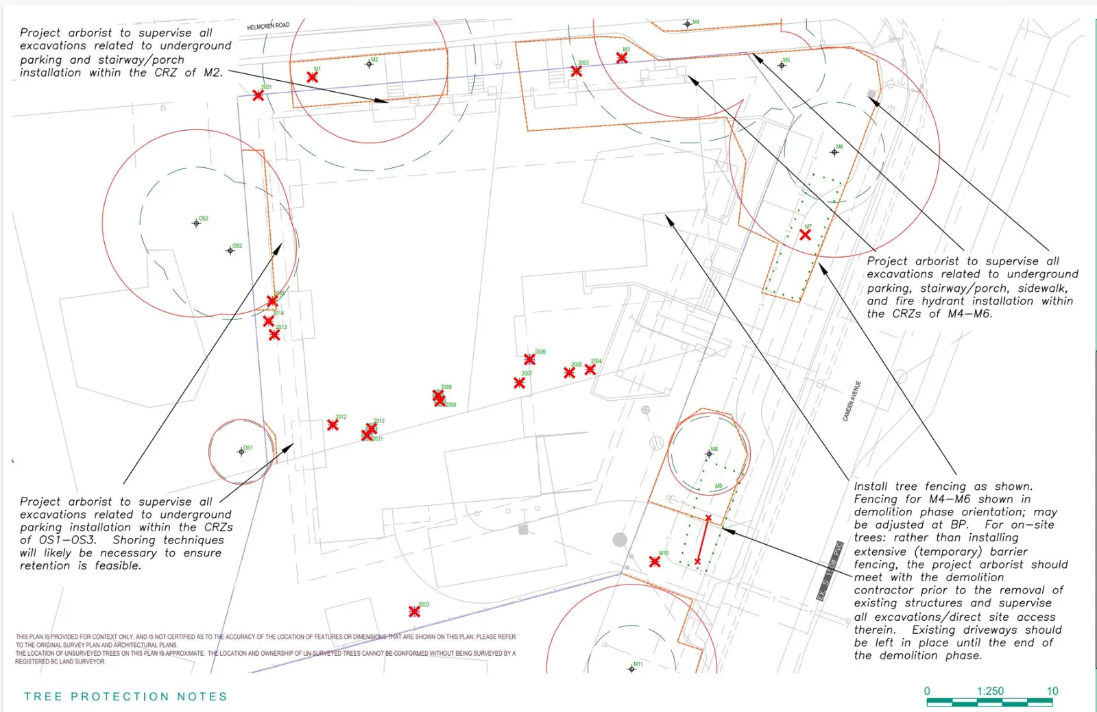
The applicant has provided an arborist report and tree management plan (Attachment 6), which details tree removal, and retention and protection measures. The proposal indicates a total of nineteen trees to be removed, of which thirteen are bylaw-protected trees under the Tree Protection Bylaw (eight trees on-site, five trees off-site).
The on-site bylaw protected trees proposed for removal are considered to largely be in poor health by the arborist, with one considered to be in good health. Staff have worked with the applicant to preserve some existing trees within the frontage. Doing so, limits the removal of off-site trees to only five trees that are municipally-owned.
The arborist report also indicates:
- six to seven potential trees “to be determined” in the field. Should these trees be required to be removed for long-term health or hazardous reasons, then these trees require replacement as indicated in the Tree Protection Bylaw.
- three trees on the neighbouring “south” lot could potentially be impacted. These trees cannot be impacted in any way by the development unless express permission is granted by the neighbouring property owner via written authorization. Therefore, the applicant will be required to protect these trees to ensure long-term survivability unless such written authorization is provided.
Tree replacements will be required in accordance with the Tree Protection Bylaw and the applicant will be required to apply for a tree permit prior to the modification of the lands.
Figure 6 - Tree Management Site Plan
Servicing Requirements
The applicant would be required to provide full frontage improvements, including streetlighting and boulevard improvements per the Subdivision and Development Servicing Bylaw and in general accordance with the conceptual servicing drawing (attached). The design would be finalized in a servicing agreement as part of the Building Permit Application process.
The operations and maintenance of the on-site stormwater management infrastructure would be the responsibility of the property owner per the Town’s Stormwater Regulation Bylaw. Staff recommend that this operations and maintenance requirement be secured in a legal agreement registered on title prior to final adoption of the bylaw, to the satisfaction of the Director of Engineering.
Traffic Impact Assessment
The applicant has provided a Traffic Impact Assessment (TIA) in support of their application. In summary, the TIA details that:
- The access on Camden is appropriately spaced from both Helmcken Road and Conard Street;
- No sight distance issues were found as there are clear sightlines from the access to Helmcken Road and along Camden Avenue; and
- The estimated new trips by the development are not expected to impact the traffic operations in the area.
The report does not identify any traffic-related concerns to be attributed to the site.
Fire Protection
Fire has no concerns with the proposed development. The building would have fire sprinklers as per the Town’s Building Sprinkler Bylaw. There are no issues with fire access.
Site Amenities
The applicant has included several amenities in their project, including a rooftop patio and garden, outdoor pavilion and seating area, an indoor amenity flex space with outdoor amenity patio, and a dog play area. Table 5 below provides a summary of the indoor and outdoor amenity areas that are proposed for this development.
Table 5 - Amenity Space Summary
| Amenity Type | Area |
|---|---|
| Roof Patio Area: | 75 m² |
| Rain Garden Area: | 63 m² |
| Pavilion Area: | 21 m² |
| Dog Play Area: | 55 m² |
| Indoor Amenity Space: | 41 m² |
| Outdoor Amenity Space: | 19 m² |
The proposed amenities are recommended to be secured in a legal agreement in perpetuity to ensure that these on-site amenities are provided for the residents of the building. These amenities are not considered to be community contributions as they do not affect the neighbourhood or the community.
Community Amenity Contributions
The applicant and staff have negotiated that $4,000 would be provided per residential unit, as detailed in the Town’s Community Amenity Contribution (CAC) Policy and secured in a legal agreement registered on title. Should twenty-seven dwelling units be provided at time of building permit application, the Town can expect an amenity contribution in the amount of $108,000.00.
As part of this contribution, 10% of the funds would be provided to the Capital Regional District (CRD) Housing Trust Fund to supplement the Town’s annual contribution.
Affordable Housing
Staff have discussed with the applicant the opportunity to provide affordable housing beyond the amount to be provided as part of the CAC Policy; however, the applicant has not indicated that they would provide any additional affordable housing beyond what is collected through the Policy. Staff will continue to review with the applicant any opportunity for affordable housing in this development.
SUSTAINABILITY/CLIMATE CHANGE IMPACTS:
The Town’s recently adopted Building Bylaw No. 1111, 2023 requires Part 3 buildings must comply with Step 2 of the BC Energy Step Code for energy efficiency. In addition, Building Permit applications for Part 3 residential buildings less than six-storeys received after July 1, 2024 must comply with Level 4 Zero Carbon Step Code, which requires that no fossil fuel appliances used for water heating, primary space heating or indoor cooking are permitted. The site’s close proximity to Eagle Creek Village, the Galloping Goose Trail, and existing transit stops along Helmcken Road and Burnside Road have the potential to reduce the number of vehicle trips generated by residents.
FINANCIAL IMPLICATIONS:
There are no significant financial implications anticipated for the Town.
CONCLUSION:
The proposal is consistent with the Mixed Residential land use designation in the OCP and further advances several OCP policies related to family-oriented housing and home ownership opportunities. The subject site is a suitable location for a multi-unit development given that it is across the street from Eagle Creek Village, on bus route, and approximately 200 metres from the Galloping Goose Trail. For these reasons, the rezoning application is supportable.
For the application to move forward any issues that are identified by the Committee of the Whole should be addressed.
| CONCURRENCE: | Initials | Comments |
|---|---|---|
| Acting Chief Administrative Officer | SJ | Support receipt |
| REVIEWED BY: | Initials |
|---|---|
| Director of Corporate Administration | n/a |
| Director of Finance | n/a |
| Director of Development Services | LT |
| Director of Engineering and Parks | IL |
| Director of Protective Services | PH |
ATTACHMENTS:
Attachment 1: Letter to Mayor and Council & Letter to Neighbourhood Attachment 2: Survey & Architectural Plans and Renderings Attachment 3: Conceptual Frontage and Servicing Attachment 4: Parking Study Attachment 5: Traffic Impact Assessment (TIA) Memorandum Attachment 6: Arborist Report and Tree Management Plan (TMP) & Letter of Assurance Attachment 7: Conceptual Landscape Plan Attachment 8: Conceptual Storm Water Management Plan (SWMP) Attachment 9: Official Community Plan Policy Summary Attachment 10: Sustainability Checklist
Document Images
(1)