Staff Report: REZONING APPLICATION 2023/01 – 339, 341, & 345 Island Highway
A report regarding a proposal to rezone three properties to a new Comprehensive Development Zone to allow for a six-storey, 238-unit rental residential development.
TOWN OF VIEW ROYAL COMMITTEE OF THE WHOLE REPORT
TO: Committee of the Whole FROM: Stirling Scory, RPP, MCIP, Community Planner DATE: August 29, 2023 MEETING DATE: September 12, 2023
REZONING APPLICATION 2023/01 – 339, 341, & 345 Island Highway
RECOMMENDATION:
THAT the report dated August 29, 2023, from the Community Planner titled “Rezoning Application 2023/01 – 339, 341, & 345 Island Highway” be received for information.
PURPOSE:
The purpose of this report is to present a Rezoning application for information, for the properties located at 339, 341, and 345 Island Highway. The applicant is proposing to rezone the subject properties from C-5: Tourist Commercial to a new Comprehensive Development Zone to build a six-storey, multi-unit residential development, with approximately 238 rental dwelling units.
TIME CRITICAL:
At this time, there are no concerns regarding timing for the municipality.
EXECUTIVE SUMMARY:
The purpose of the rezoning application for the properties located at 339, 341, and 345 Island Highway is to rezone from the C-5: Tourist Commercial to a new Comprehensive Development Zone to permit a six-storey, multi-unit residential building with a proposed density of 1.6:1 FSR (floor space ratio) and consisting of approximately 238 apartment dwelling units. The proposal incorporates a mix of housing types, including bachelor, one-, two-, and three-bedroom units, and amenities such as an outdoor play area and barbecue space, indoor amenity flex space, and a dog park. The proposal complies with the use and density provisions supported by the Mixed Residential land use designation in the Official Community Plan (OCP); and therefore, an amendment to the Plan is not required.
Prior to consideration of first and second reading, staff have outlined some items requiring further clarification and revision. A rezoning application only addresses zoning related items, including land use, density, lot coverage, impermeable surface area, and the height and setbacks of buildings. Should the rezoning be approved, the applicant will be required to apply for a form and character Development Permit.
BACKGROUND:
On June 13, 2023, the rezoning application was presented to Committee of the Whole for information. During the meeting, the Committee provided the applicant with feedback and suggestions for the application, recommending that the applicant come back with changes to the proposal. The applicant has revised the proposal in response to Council and staff comments.
Site Characteristics
The site is a land area of approximately 12,129 m² split across three development sites. The subject properties are located on the border of the Harbour and Helmcken Neighbourhoods, identified in the Official Community Plan (OCP). The site is located across the street from Fort Victoria and is adjacent to the Fire Hall and Public Safety Building. The site is also located on the periphery of an existing established residential neighbourhood and adjacent to Heddle Park. Heddle Park is identified as a future trail connection and has yet to be formally maintained as such. An overview of the development site and the surrounding properties is as follows:
Table 1 – Land Use Designation and Zoning Review
| Address | Land Use Designation | Zone | Land Use Designation | Use | |
|---|---|---|---|---|---|
| Subject Property | 339, 341, 345 Island Highway | Mixed Residential | C-5: Tourist Commercial | Mixed Residential | Single Family and multiple duplex dwellings |
| North | 340 Island Highway | Intensive Mixed Use (IMU) | C-6: Tourist Commercial (Campground) | Intensive Mixed Use (IMU) | Fort Victoria |
| West | 347 Island Highway and 585 Prince Robert Drive | Mixed Residential (M-R) | CD-13: Comprehensive Development (Island Highway) R-2: Duplex Residential | Mixed Residential (M-R) | Duplex and single family detached dwellings |
| East | 333 Island Highway | Community Facility (CF) | P-8: Public Safety | Community Facility (CF) | Fire Hall & Public Safety Building |
| South | 590, 560, 552, 550, and 542 Prince Robert Drive | Large Lot Residential (R-L) | R-1: Detached Residential (Large Lot) P-7: Utility Corridor | Large Lot Residential (R-L) | Single family detached dwellings and Heddle Park (594 Prince Robert Drive) |
The site has historically been used as below-market rental housing in the community. There is a single building at 339 Island Highway, four buildings located at 341 Island Highway, and five buildings located at 345 Island Highway. In total, the buildings contain 37 rental dwellings, of which 31 are actively used between the three properties. Earlier this summer two separate fires occurred on the property and damage sustained resulted in the net loss of dwelling space. Not all units in the building are occupied so the affected tenants could move within the three properties.
PROJECT INFORMATION:
The proposal is to rezone the subject properties located at 339, 341, and 345 Island Highway from C-5: Tourist Commercial to a new comprehensive development zone. A rezoning application addresses zoning related items, including land use, density, lot coverage, impermeable surface area, and the height and setbacks of buildings. For the purposes of this report the smaller of the two buildings will be referred to as Building A and the larger building will be referred to as Building B.
The proposal is summarized as follows:
Table 2 - Zoning Review
| Regulation | Permitted C-5: Tourist Commercial Zone | Proposed Comprehensive Development Zone |
|---|---|---|
| Floor Space Ratio | 0.4:1 | 1.6:1 |
| Lot Coverage | 50% | 29% |
| Impermeable Coverage | 80% | TBD |
| Building Height (m) | 9 | 19.2 m (6 storeys) |
| Front Yard Setback (m) – Prince Robert Drive) | 7.5 m | 8.0 m |
| Side Yard Setback (m) – (Heddle Park) | 6.0 m | 8.5 m |
| Rear Yard Setback (m) – (Fire Hall) | 7.5 m | 6.0 m |
| Flanking Yard Setback (m) – (Island Highway) | 3.0 m | 8.0 m |
The applicant is proposing a total of 300 underground parking spaces. The required parking for the proposal is 297 parking spaces, which results in a surplus of three regular parking spaces. Of the total parking required on-site, the proposal must provide three accessible parking spaces, which have not been labelled on the plans. The accessory parking spaces must be identified on the parking plan for the development permit application submission.
Table 3 – Parking Review
| Parking by Type | Units | Parking Requirement | Parking Proposed |
|---|---|---|---|
| Studio | 5 | 1 per dwelling unit | 5 |
| 1 Bedroom | 120 | 1 per dwelling unit | 120 |
| 2 Bedroom | 108 | 1.5 per dwelling unit | 162 |
| 3 Bedroom | 05 | 2 per dwelling unit | 10 |
| Total Small Car Parking (%30) | N/A | 90 (maximum) | No small parking indicated. |
| Electric Vehicle Parking Space (Level 3 – 240 Volt) | Every required parking space. | 1 | 297 spaces |
| Accessible Parking | 1 per every 100 where 50 or more spaces provides | 3 | 0 |
| Bicycle Parking | 238 Dwelling Units | 1 per dwelling unit | 238 |
*NOTE: All required residential and bicycle parking (Class 1) must be electrified to the specified requirements of the Zoning Bylaw definitions for Energized Electric Vehicle Outlet and Energized Electric Bicycle Outlet.
It is recommended that a site-specific zone be drafted should Council choose to advance the application. However, in a number of instances, variances are recommended (instead of inclusion into the new zone), to ensure that if this proposal is not built, that Council review and consideration would be required again, should a different proposal be advanced in the future.
The applicant is proposing to provide approximately 238 dwelling units, including studio, one-, two-, and three-bedroom apartments, as detailed below in Table 3. In addition, the applicant is proposing that a single indoor amenity space be provided on the ground floor of Building B.
Table 4 - Unit Mix Overview*
| Type | Number Of Units | % of Total | Size (sq. ft.) |
|---|---|---|---|
| Studio | 5 | 2% | 450 – 575 ft² |
| 1 Bedroom | 120 | 50% | 600 – 710 ft² |
| 2 Bedroom | 108 | 45% | 845 – 905 ft² |
| 3 Bedroom | 5 | 2% | 1,105 ft² |
| Amenity Space | 1 | N/A | 1450 ft² |
*NOTE: The number of units provided and the size of the units are conceptual and is subject to change prior to building permit issuance.
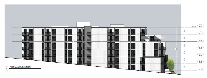
Figures 1 to 8 below are the proposed conceptual drawings.
Figure 1- Conceptual Rendering Perspective at Island Highway and Prince Robert Drive
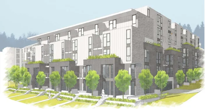
Figure 2 – Conceptual Rendering Perspective at Island Highway and Burnett Road
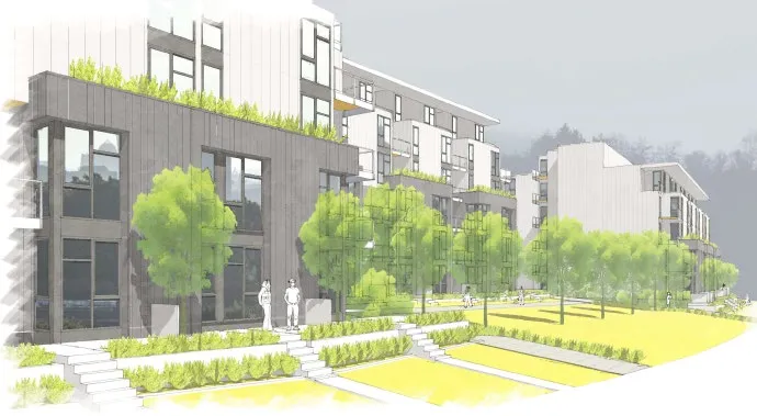
Figure 3 - Conceptual Rendering of Site Plan
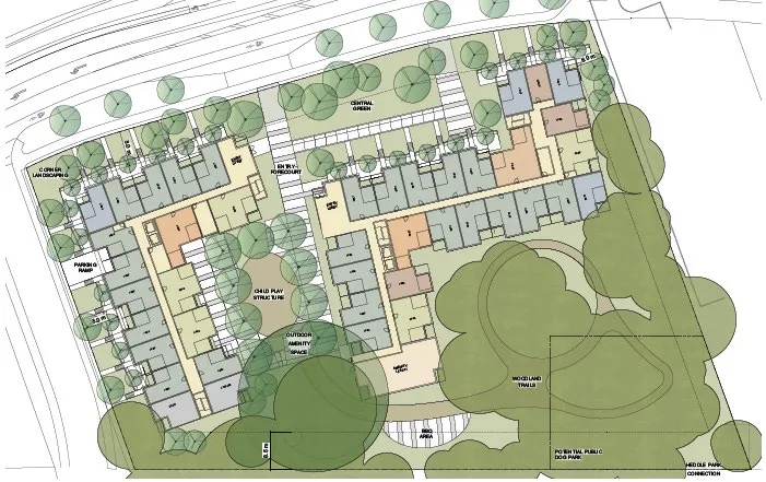
Figure 4 - Conceptual Rendering of Underground Parking
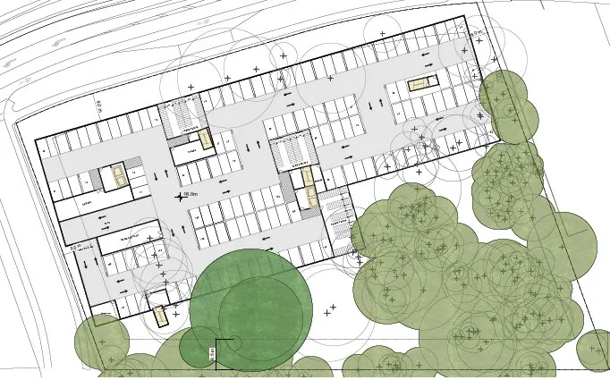
Figure 5 - Conceptual Rendering of Building A and B Cross Section
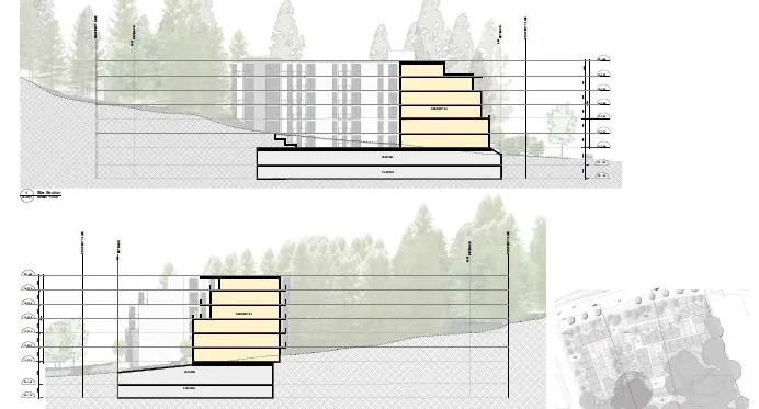
Figure 6 - Conceptual Digital Elevation Model of the Flanking Yard (Island Highway)
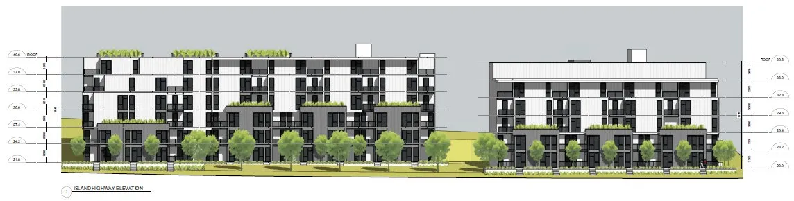
Figure 7 - Conceptual Digital Elevation Model of the Side Yard (Heddle Park)
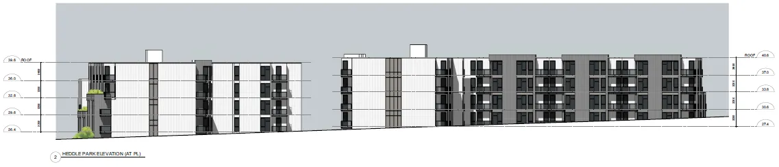
Figure 8 - Conceptual Digital Elevation Model of the Front Yard (Prince Robert Drive)
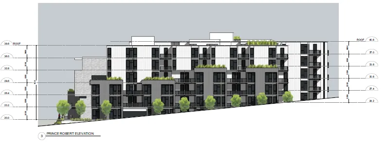
Figure 9 - Conceptual Digital Elevation Model of the Rear Yard (Fire Hall)
DISCUSSION:
In review of a rezoning application, an examination of the proposal’s ability to meet the intended objectives and policies of the Town’s Official Community Plan Bylaw No. 811, 2011 and regulations of Zoning Bylaw No. 900, 2014 must be taken into consideration. In addition, analysis of the potential land use impacts is also considered.
1. Official Community Plan Review
The development site is located on a major multimodal road but is not located within an identified Neighbourhood Centre or Community Centre, identified in the OCP. The site is across the street from Fort Victoria, an area designated as a future Town Centre in the OCP.
The site’s OCP land use designation is “Mixed Residential”, which supports the following land uses and densities:
- small lot detached houses, townhouses, and low-rise apartments up to 3 storeys and a maximum 1.25:1 floor space ratio (FSR); or
- four storeys for apartment dwellings and a maximum floor space ratio of 1.6:1 FSR.
The proposal meets the intended density provision, but exceeds the maximum number of storeys. The applicant will require a variance to increase the maximum permitted height of the building, which is regulated through the Zoning Bylaw. This variance will be part of a future development permit for form and character, should the rezoning be approved.
The proposal further advances several policies and objectives in the OCP. Summarized below is a list of some relevant policies pertaining to the rezoning application. A complete list of relevant policies may be reviewed in Attachment 7.
- Policy LU1.1 Neighbourhood Centres
- Create a network of neighbourhood-serving, mixed-use centres and encourage new and infill residential and commercial growth
- Policy LU1.4 Diversity of Forms and Uses
- Support a variety of residential and commercial forms and uses to encourage socio-economic diversity.
- Policy LU4.2 Support Walking, Cycling and Transit
- Encourage higher density and mixed-use development at neighbourhood centres and along major transit corridors to promote walkability, cycling and transit use. Support higher residential density, commercial intensity and reduced parking requirements in areas well served by transit.
- Policy LU4.5 Street-oriented Buildings
- Encourage street-oriented buildings.
- Policy HS1.1 Range of Housing Types
- Ensure the policies of this Plan and the regulations of the Zoning Bylaw support a range of housing, including detached homes, small lot subdivisions, apartments, townhouses, secondary suites and other typologies that meet the housing needs of current and future residents.
- Policy HS1.6 Loss of Rental Housing
- Where a proposed subdivision of multi-unit residential development would result in the loss of rental housing for low-income household or special needs clients, require the applicant to provide a statement outlining what provisions have been made regarding notice and relocation assistance to the tenants.
- Policy NE1.6 Native Trees and Vegetation
- Encourage the protection of native trees and vegetation in natural and developed areas.
- Policy NE1.7 Urban Forest
- Maintain a healthy urban forest by encouraging the retention of trees and ecological features, promoting tree coverage expansion and enhancing wildlife biodiversity.
2. Zoning Bylaw Review
The proposal requires a new Comprehensive Development Zone. The proposed CD zone will be drafted to contain details on the maximum permitted height, required setbacks, and density. As noted above, in staff’s review of the proposed application, a variance to the height will be required. Request for variances to the zoning bylaw will be considered in conjunction with a future development permit.
3. Potential Land Use Impacts
Transportation and Parking
A revised traffic impact assessment (TIA) was provided to the Town given the change in the development proposal. The revised report does address the third-party review that was conducted by the Town during the initial application, and Engineering is in support of the applicant’s requirement to install a new traffic signal at the Island Highway / Prince Robert Drive intersection at their expense.
Engineering is also in support of the other recommended improvements stipulated in the TIA whereby the applicant is to at their expense:
- install a 25m westbound left turn lane on the Island Highway at Prince Robert Drive (for left turning from the Island Highway into Prince Robert Drive);
- install a sidewalk with landscaped boulevards along the development frontage of the Island Highway;
- upgrade the existing bus stops as per BC Transit and the Town’s direction (complete with bus pad and shelter).
The TIA also recommends consideration of converting the centre “painted median” on the Island Highway into a “two-way left turn lane”, between Prince Robert Drive and Burnett Road. The Town’s Transportation Master Plan, its Technical Update, and Subdivision and Development Bylaw supports this, however, the works would require widening the roadway northwards, thus requiring Capital work. The Town currently has a Capital design project in 2024 to provide a shelf ready street design on the Island Highway, from Helmcken Road to the Colwood Interchange (Project C-076). Staff recommend deferring considerations for a two-way left turn lane until this detail design project is underway: at that time Council may wish to time the widening works concurrently with the applicant’s frontage works to fully upgrade the roadway within the vicinity of this development site.
A cost share for the road widening at Prince Robert Drive, as demonstrated in the Applicant’s concept plan, will be required to ensure the road remains fully in Town right of way.
Frontage improvements are to incorporate the above noted requirements, to be in accordance with the Subdivision and Development Bylaw 985, shown conceptually in the applicant’s concept plan, and to the satisfaction of Protective Services regarding emergency access. Detail design and installation will be secured as part of the Servicing Agreement for the development.
On-site Parking
On-site parking requirements have been provided above in the project information section of this report. A review of all parking regulations as per Section 5 of Zoning Bylaw No. 900, 2014 will be confirmed at the Development Permit stage when the number of units and siting and design of the building are confirmed.
Site and Fire Access
Engineering and Planning are supportive of a singular vehicle access off Prince Robert Drive.
Currently, the site plan does not meet fire truck access requirements. The Fire Department must be able to access the buildings on-site via the aerial ladder truck, which requires enough space to enter/exit and operate on the site. The applicant is working with staff to ensure that the proposal meets the access requirements to the satisfaction of the Director of Protective Services and Director of Engineering and Parks. A revision to the site plan will be required prior to consideration of first and second reading of the bylaw should Council advance the application to a public hearing.
Environmental Impacts
The site is not within an environmental development permit area; however, the site does contain a large stand of trees. The applicant’s proposal looks to preserve the large urban forest canopy at the southeast corner of the development site, and to construct a low impact walking trail in the area.
The applicant has provided an arborist report that notes there are invasive species, including English Ivy. Staff have also observed this and other invasive species such as daphne / spurge laurel and thus recommend that as part of the development of the site and proposed trail system, the applicant provide an invasive species removal and restoration plan prior to issuance of a development permit and that this is secured in a section 219 covenant as a condition of rezoning.
Tree Impacts
A revised arborist report was provided to the Town (Attachment 3) detailing tree preservation and protection measures, and removal requests. The revised report reduces the number of on-site trees to be removed from 138 trees to potentially 43 trees (subject to future assessment). Therefore, a total of 125 potential on-site trees and 3 trees with shared ownership (municipal and applicant) will be retained and protected. A total of 19 municipal trees and 3 hedges are in the proximate location of the development site; all are retainable through appropriate protection measures outlined in the arborists report. The report confirms that there are no off-site private trees that will be impacted. Figure 10 illustrates the proposed tree management plan.
The revised arborist report also identifies several trees in good health but is a species with a poor tolerance to changes in its growing environment, or has structural defects that would require measures to be implemented to consider it suitable for retention. To improve the survivability of these trees, staff recommend that the applicant provide a tree maintenance plan as part of the building permit process. In addition to tree fencing that is incidental to the Subdivision and Development Bylaw, the additional measures can be required as indicated in the arborist report: mulching, irrigation measures (especially in the dry season), and reduced blasting. Council may consider alternative foundation construction methods such as shoring to provide further protections.
Figure 10 - Conceptual Tree Management Plan
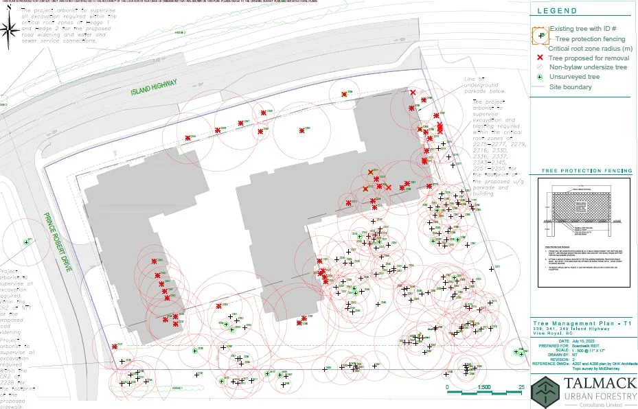
Staff note that by moving Building B closer to Island Highway could retain additional trees in the southern west corner of the site. Moving Building A closer to Island Highway may retain some additional trees; however, putting the building too close to the right-of-way may have impacts on sight lines. This would also make the appearance of the building larger from the Island Highway perspective. Siting the building closer to the street improves the streetscape and provides for a pedestrian-oriented building design and is consistent with the OCP design guidelines.
A detailed landscape plan has not been prepared, but will be a requirement at the Development Permit Application stage, should the rezoning be approved. The renderings show some new tree plantings, but it is unknown if the required 2:1 replacement requirement of 86 trees is satisfied. This would also be confirmed at Development Permit.
Should the application proceed, a tree permit, supplemented by a tree maintenance plan as described above, will be required prior to issuance of building permit. An arborist will be required to be on-site during construction to ensure protection measures area followed.
Servicing Requirements
The conceptual servicing report provided by the applicant (Attachment 2) was reviewed to determine potential impacts to the downstream system. Based on the additional sewer loading, a review of the Town’s Sanitary Master Plan suggests that the existing sewer main directly in front of the development may be undersized and may require an upgrade as a result. An upgrade may not be required if future analysis during the servicing agreement dictates that the development does not impact this sewer main section. The sanitary sewer design requirements will be determined at time of building permit approval through a servicing agreement.
The Town agrees with the conceptual stormwater design in principle. A complete review and approval of the system will be confirmed at time of building permit approval through a servicing agreement. Engineering will require that a Section 219 covenant be registered on title prior to building permit to ensure that the applicant operates and maintains the onsite stormwater infrastructure in accordance with the applicant engineer’s (applicant’s engineer) operation and maintenance manual and the Storm Water Regulation Bylaw 902.
On-site Outdoor Amenities
The applicant proposes an on-site trail and greenspace area, children’s play area, a public dog park, and barbeque area (refer to Attachment 1) for the residents. Staff have provided feedback to the applicant to site the proposed barbeque area away from the side yard, as this was previously discussed to be maintained as a natural buffer area. A public dog park on private property poses significant challenges for staff to maintain, access, and its remoteness from the public access creates challenges for private/public space access rights for residents and members of the public. Staff do not recommend having a public dog park on the property. In addition, staff do not support a connection between the development site and Heddle Park due to access maintenance, public and private space access management, and concerns with the ability to follow crime prevention through environmental design (CPTED) principles. Staff would require that the property’s rear yard (fire hall) and side yard (Heddle Park) be fenced as per the Official Community Plan design guidelines. Staff are supportive of the proposed on-site green space with trails, provided that the trails can developed and used without damaging the urban forest.
Green Space and Natural Buffer
As a condition of rezoning, staff recommend that a covenant be registered on title to protect and establish a natural buffer area adjacent to Heddle Park, and to preserve the proposed green space on-site for trail use. Staff will continue conversations with the applicant to discuss what opportunities are viable within a covenant area, while considering the long-term protection of this buffer area.
Staff will also further conversations regarding the protection of the proposed green space on the property that is to be used for a trail. Staff recommend that a covenant area be registered to protect from future building interests, but to allow for minor landscaping work such as planting or the placement of a bench, and on-going maintenance of the trail.
Foundation and Underpinning
The applicant must obtain permissions from neighbouring properties to site underpinnings that encroach onto adjacent properties. For municipal property, the applicant must receive an encroachment agreement from the Town. Where underpinnings are to be sited in the road right-of-way, the applicant must receive an encroachment agreement from the Town, and approvals of the Capital Regional District (CRD) given the proximity of their water supply and distribution infrastructure to the site.
4. Amenity Contributions
The Town’s Community Amenity Contribution (CAC) Policy provides guidance and to assist in establishing targets for community amenity contributions in association with rezoning applications for changes in residential land use and density. The policy states that new development should provide a fair contribution and help address the needs of a changing community and some impacts of growth. Community amenities are those identified in the OCP and other Town documents, or those accepted by Council through the development application process. Council may determine what is considered a community amenity and should be done on a case-by-case basis.
In accordance with the Policy, the applicant completed a Land Lift Analysis due to the proposed number of dwelling units. The land lift was completed by Mulholland & Parker Land Economists Ltd and is attached to this report (Attachment 8). The purpose of the analysis is to estimate the land lift (value) and amenity contribution on the site due to a change in the permitted use and density. Where a lift in land value is determined, the Town would take 50% of the lift value, and the cost to complete the study would be deducted from the community amenity contribution amount. The analysis that was completed by the applicant was in the spring of 2023 and was used for the applicant’s submission for Committee of the Whole on June 13, 2023. The land lift determined there was no residual land value supported by the proposed application at the time which included 259 rental apartment units and 1,575 square feet of commercial space. Since then, the applicant has revised their proposal which no longer includes commercial space and decreases the proposed residential density from 1.73:1 FSR to 1.6:1 FSR (259 to 238 dwelling units). A further decrease in density supports the findings of the land lift completed; a lift has not occurred.
Where there is no or negative land lift, alternative community amenities may be negotiated. The OCP acknowledges the challenges concerning the lack of affordable housing in the community, and the greater Victoria area, and the growing concern with rising housing and land costs. Accordingly, the OCP strongly encourages the inclusion of affordable housing units (below market housing) in larger multi-family residential developments. Staff have continued to request that the applicant consider providing below-market and accessible housing units in this development; however, the applicant has indicated to staff that it is not financially feasible given current inflation and costs of construction. However, providing affordable rental dwellings, and a mix of dwelling unit sizes further advances housing objectives and policies in the OCP. Given the proximity of the site to transit stops, the E&N Trail, and its proximity to the Helmcken-Harbour Community Corridor, the development site is an ideal location to provide some below-market rental housing for persons of a lower income as a community amenity.
Alternatively, the Policy does stipulate cash contributions as a community amenity in the amount of $4000 per unit be provided for a multi-family project as a starting point and is open to negotiation. Staff will continue to explore opportunities for community amenity contributions with the applicant, subject to Council feedback, and report back to Council prior to bylaw readings, should the application advance to a public hearing.
5. Tenant Assistance Plan
The applicant has provided a tenant assistance and relocation plan (Attachment 5). The document outlines how tenants will be compensated to assist with rent and moving expenses. The details of this plan will be finalized prior to consideration of public hearing. The application is exempt from the Tenant Assistance Policy.
6. Public Engagement
The applicant has completed public engagement throughout the project; an overview of the applicant’s engagement to date is available for review in Attachment 9.
SUSTAINABILITY/CLIMATE CHANGE IMPACTS:
The proposal will impact the existing urban forest in the short term, with a reduction of 43 trees on the development sites. There is opportunity for urban forest recovery long-term with the provision of landscaping and tree replacement, to be determined via a landscaping plan accepted at the Development Permit stage.
The proposal must meet Step 2 of the British Columbia Energy Step Code requirements at the time of building permit application.
The applicant has completed the Town’s Sustainability Checklist and has been attached to this report (Attachment 6).
FINANCIAL IMPLICATIONS:
The Town will be responsible for maintaining a new signalized intersection, sidewalks, a boulevard, and new trees once installed by the applicant.
NEXT STEPS:
Prior to consideration of first and second reading, staff have discussed with the applicant that further revisions will be required to the plans. The requested revisions include, but are not limited to, the following:
- Confirm fire truck access; the site must be designed to permit fire engine access to the buildings for aerial ladder placement.
- The proposed location of the dog park and BBQ area are to be moved so that they are not located within the previously identified natural buffer area.
- Further clarifications and technical refinements to the architectural drawings.
- Applicant to review opportunities for further enhancement of building siting and design to align with the Official Community Plan Mixed Residential Form and Character design guidelines (to be determined at Development Permit Stage).
- Further review and discussion regarding community amenity contributions.
ALTERNATIVE RECOMMENDATION:
There is no alternative recommendation.
CONCLUSION:
Should the Committee pass the recommended motion, staff will continue to work with the applicant on the revisions and community amenity contribution package prior to bringing forward the application to Council for formal consideration ahead of first and second reading. Any feedback that is provided by the Committee will be reviewed and incorporated as required. Staff recommend that the application be received for information and that the application be brought forward to Council for formal consideration of first and second reading.
| CONCURRENCE: | Initials | Comments |
|---|---|---|
| Chief Administrative Officer | KA | Recommend Approval. |
| REVIEWED BY: | Initials |
|---|---|
| Director of Corporate Administration | NA |
| Director of Finance | NA |
| Director of Development Services | LT |
| Director of Engineering and Parks | IL |
| Director of Protective Services |
ATTACHMENTS:
- Conceptual Architectural Site Plan and Building Design Drawings
- Conceptual Frontage and Servicing
- Arborist Report and Tree Protection Plan
- Traffic Impact Assessment prepared by Watt Consulting
- Tenant Relocation and Assistance Plan and Rent Roll
- Sustainability Checklist
- List of Relevant Official Community Plan Policies
- Landlift Analysis
- Community Engagement Summary
Document Images
(1)