REZONING AND OFFICIAL COMMUNITY PLAN AMENDMENT 2023/01 – 339, 341, & 345 Island Highway
A report from the Community Planner reviewing an application to rezone and amend the OCP to facilitate a 259-unit mixed-use development.
TOWN OF VIEW ROYAL
COMMITTEE OF THE WHOLE REPORT
TO: Committee of the Whole DATE: May 24, 2023 FROM: Stirling Scory, RPP, MCIP, Community Planner MEETING DATE: June 13, 2023
REZONING AND OFFICIAL COMMUNITY PLAN AMENDMENT 2023/01 – 339, 341, & 345 Island Highway
RECOMMENDATION:
THAT the report dated May 24, 2023, from the Community Planner titled “Rezoning and Official Community Plan Amendment 2023/01 – 339, 341, and 345 Island Highway” be received for information.
PURPOSE:
The purpose of this report is to present a Rezoning and Official Community Plan (OCP) Amendment application for the properties located at 339, 341, and 345 Island Highway. The proposal is to rezone the subject properties from the existing C-5: Tourist Commercial Zone to a new Comprehensive Development Zone and amend the OCP land use designation from Mixed-Residential to Neighbourhood Centre to construct a mixed-use development consisting of three buildings ranging in heights from six to eight storeys, with some ground floor commercial and approximately 259 rental apartment units.
TIME CRITICAL:
Currently, there are no concerns regarding timing from staff.
EXECUTIVE SUMMARY:
The purpose of this report is to provide the Committee with information, analysis and recommendation for a rezoning and official community plan amendment application for the properties located at 339, 341, and 345 Island Highway. The proposal is for a mixed-use development with a density of 1.74:1 floor space ratio (FSR) and approximately 259 apartment dwelling units and 1575 ft2 of commercial space. An amendment to the land use designation in the OCP from Mixed-Residential to Neighbourhood Centre is required to facilitate this development. The scope and intent of a rezoning and OCP amendment application are strictly to consider the use, density, height, and siting of buildings on the land. Form and character of the buildings and associated landscaping will be considered at time of development permit.
BACKGROUND:
The properties located at 339, 341, and 345 Island Highway comprise of a land area of approximately 12,129 m2. The site is presently occupied by ten buildings, which consist of a total of 36 rental dwelling units. The subject properties have been historically used as below-market rental housing in the community.
The site is located across the street from Fort Victoria, and adjacent to the Fire Hall and Public Safety Building. It also abuts Heddle Park, a small park that separates the development site and existing single-family homes to the south. Heddle Park is identified as a future trail connection.
The subject properties are located on the borders of the neighbourhoods identified in the OCP as the Harbour Neighbourhood (where this property is located) and the Helmcken Neighbourhood. The surrounding properties are zoned as follows:
Table 1 - Zoning and Land Use Review
| Address | Zone | Land Use Designation | Use | |
|---|---|---|---|---|
| Subject Property | 339, 341, 345 Island Highway | C-5: Tourist Commercial | Mixed Residential | Single-Family and multiple duplex dwellings |
| North | 340 Island Highway | C-6: Tourist Commercial (Campground) | Intensive Mixed Use (IMU) | Fort Victoria |
| West | 347 Island Highway and 585 Prince Robert Drive | CD-13: Comprehensive Development (Island Highway) R-2: Duplex Residential | Mixed Residential (M-R) | Duplex and single-family detached dwellings |
| East | 333 Island Highway | P-8: Public Safety | Community Facility (CF) | Fire Hall & Public Safety Building |
| South | 590, 560, 552, 550, and 542 Prince Robert Drive | R-1: Detached Residential (Large Lot) P-7: Utility Corridor | Large Lot Residential (R-L) | Single family detached dwellings and Heddle Park (594 Prince Robert Drive) |
PROJECT INFORMATION:
Zoning Review
The proposal is to rezone the subject properties from C-5: Tourist Commercial to a new comprehensive development zone. The following zoning data table compares the proposal with the existing C-5 Zone.
Table 2 - Zone Summary
| Existing (Permitted) (C-5: Tourist Commercial) | Proposed (New CD Zone) | |
|---|---|---|
| Floor Space Ratio | 0.4:1 | 1.74:1 |
| Lot Coverage (%) | 50 | 68 |
| Impermeable Coverage (%) | 80 | More information required. |
| Building Height (m) | 9 | 22.7 (8 storeys max. shown) |
| Front Yard Setback (m) – Prince Robert Drive) | 7.5 | 6 |
| Side Yard Setback (m) – (Heddle Park) | 6 | 8 |
| Rear Yard Setback (m) – (Fire Hall) | 7.5 | 6 |
| Flanking Yard Setback (m) – (Island Highway) | 3 | 6 |
The applicant has provided a conceptual design showcasing how the site may be developed given the proposed density, setbacks, and heights.
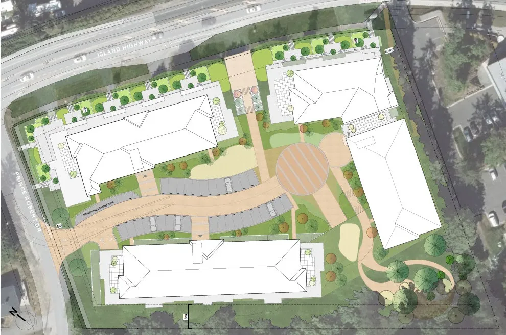
For the purposes of this report the buildings will be identified as building numbers 1, 2, and 3. For clarity, the site plan (Figure 1) references the assigned building numbers. Building one is six storeys, building two is eight storeys, and building three is seven storeys based on the definitions of the Zoning Bylaw.
The permitted number of storeys defined in the OCP is six; however, it is important to note that the number of storeys calculated is based on technicalities of the Zoning Bylaw and the additional storeys are the result of the site topography and the design of the underground parking. There may be opportunity to reduce the height of the buildings by locating the parking further underground to avoid having some of the parking structure above grade; however, a redesign to locate parking further underground would be at significant cost to the applicant, and may alter the proposal (i.e. number of dwellings, site design, more impact to trees). As proposed, the applicant would be required to vary the height of the building. Building two would appear to be eight storeys because of topography and the building’s stepped design along single building face that extends from Island Highway to the rear of the property.
The proposed parking for residential units meets the zoning bylaw requirements; however, the parking calculations do not account for accessible parking requirements. The applicant would require a variance of two spaces for the total required commercial parking for the site. Further details on parking stall dimensions have to be confirmed to understand if additional variances are required. A loading space has been provided for the commercial space but is not required. A parking summary is provided in Table 2 below.
Table 3 - Parking Summary
| Parking by Type | Units | Parking Requirement | Parking Proposed |
|---|---|---|---|
| Studio | 7 | 1 per dwelling unit | 7 |
| 1 Bedroom | 117 | 1 per dwelling unit | 117 |
| 2 Bedroom | 130 | 1.5 per dwelling unit | 195 |
| 3 Bedroom | 5 | 2 per dwelling unit | 10 |
| Total Small Car Parking (%30) | 35 (spaces proposed) | 99 (max permitted) | 35 |
| Electric Vehicle Parking | 1 | 0 (variance) | |
| Accessible Parking | 3 | 0 (variance) | |
| Commercial Parking | 146 m2 (1575 sq ft) | 1 per 15 m2 (café) | 8 (variance) |
| Commercial Loading Zone | Not required | 1 | |
| Bicycle Parking | 259 | 1 per dwelling unit | 1 per dwelling unit (259 total spaces) |
Note: the required parking for a commercial use is dependent upon the use.
Figure 1 - Site Plan
Document Images
(1)