339 / 341 / 345 Island Highway Traffic Impact Assessment
A technical report assessing the traffic impacts of a proposed 260-unit multi-family residential development, including trip generation analysis and intersection performance through a 10-year horizon.
TABLE 2: PEAK HOUR TRIP GENERATION RATES
| ITE Land Use | Weekday AM | Weekday PM | |||||
|---|---|---|---|---|---|---|---|
| Code | Description | Rate | In | Out | Rate | In | Out |
| 221 | Multi-Family Housing (Mid-Rise) | 0.37 | 23% | 77% | 0.39 | 61% | 39% |
TABLE 3: ESTIMATED DEVELOPMENT TRIPS
| Description | Units | Weekday AM | Weekday PM | ||||
|---|---|---|---|---|---|---|---|
| In | Out | Total | In | Out | Total | ||
| Multi-family (Mid-Rise) | 260 | 22 | 74 | 96 | 62 | 39 | 101 |
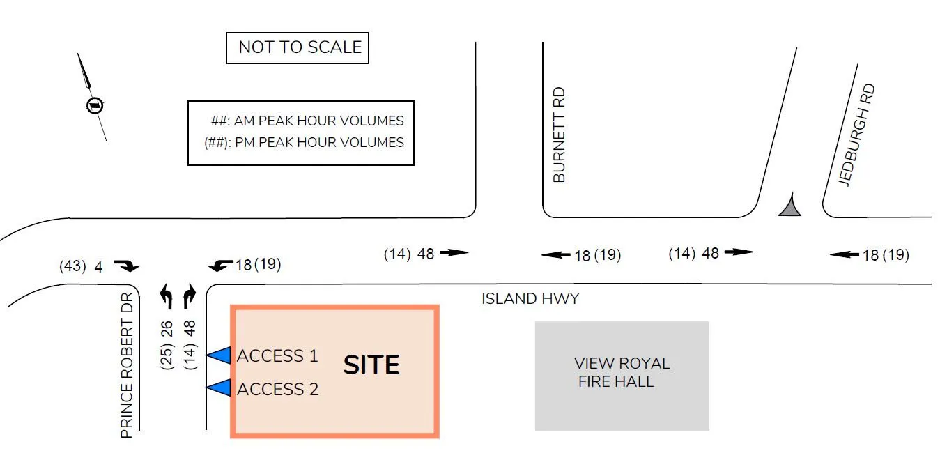
3.4 TRIP ASSIGNMENT
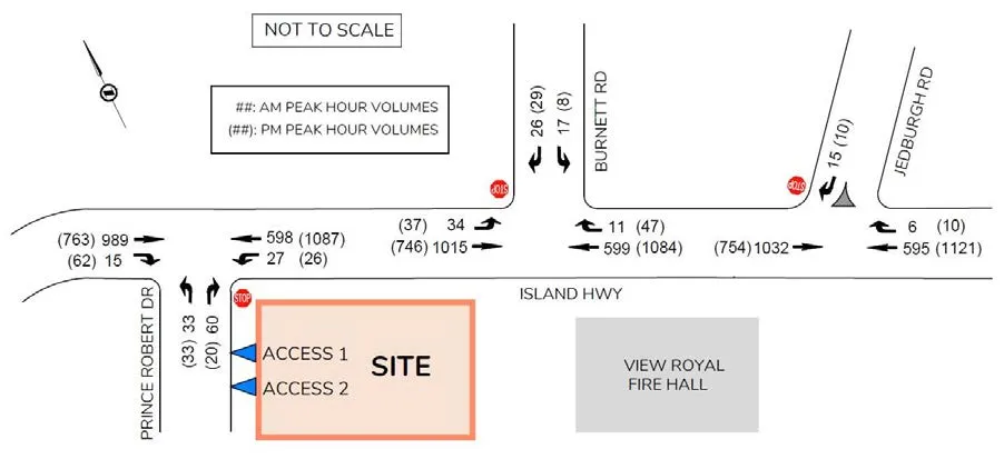
The trip assignment was based on existing trip distributions for traffic in the area and key destinations / origins. Table 4 summarizes the distribution percentages of the site trips at the study intersections, while trip assignments are shown in Figure 4.
TABLE 4: DISTRIBUTION PERCENTAGES OF SITE TRIPS
| AM Peak Hour | PM Peak Hour |
|---|---|
| • 65% of trips to Island Hwy East | • 35% of trips to Island Hwy East |
| • 35% of trips to Island Hwy West | • 65% of trips to Island Hwy West |
| • 80% of trips from Island Hwy East | • 30% of trips from Island Hwy East |
| • 20% of trips from Island Hwy West | • 70% of trips from Island Hwy West |
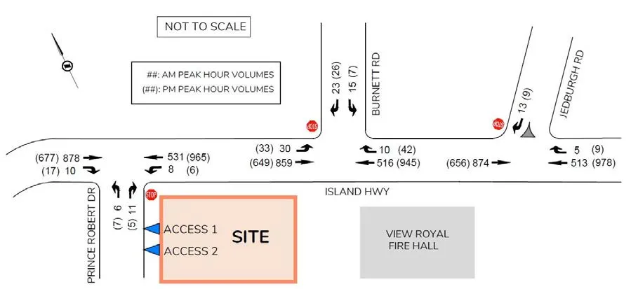
3.5 2025 OPENING DAY BACKGROUND CONDITIONS
It is assumed that the opening day is in 2025. 2025 base volumes were projected using a 1.2% annual growth rate scaled up from the 2022 volumes. The 1.2% annual growth rate was estimated based on the 2018 counts at Island Highway / Helmcken Road and the Crown Regional District’s (CRD) historical data in the area. 2025 background conditions for the opening day were analyzed for the three key intersections based on the estimated 2025 volumes and current traffic control / laning.
At Island Highway / Prince Robert Drive, the stop-controlled northbound movement will continue to operate at LOS D in the AM / PM peak hour. The westbound left queues on Island Highway will increase slightly to 13m / 16m in the AM / PM peak hour.
At Island Highway / Burnett Road, the stop-controlled southbound movement will continue to operate at LOS D in the AM peak hour but drop to LOS E in the PM peak hour. The estimated eastbound left queues (14m or less) stay within the existing storage length (20m).
The intersection of Island Highway / Jedburgh Road will continue to operate at LOS C or better for all movements in the AM and PM peak hours. See Table 5 for the results of the analysis. See Figure 5 for 2025 opening day background volumes.
TABLE 5: 2025 OPENING DAY BACKGROUND CONDITIONS
| INTERSECTION | MOVEMENT | AM Peak Hour | PM Peak Hour | ||||||
|---|---|---|---|---|---|---|---|---|---|
| LOS | Delay (s) | v/c Ratio | Queue (m)* | LOS | Delay (s) | v/c Ratio | Queue (m)* | ||
| ISLAND HWY / PRINCE ROBERT DR (EB/WB=ISLAND HWY) | EBTR | A | 0.0 | - | 6.0 | A | 0.0 | - | 1.8 |
| WBLT | B | 10.4 | 0.02 | 12.7 | A | 9.2 | 0.01 | 15.9 | |
| NBLR | D | 32.0 | 0.18 | 12.4 | D | 34.2 | 0.17 | 9.6 | |
| ISLAND HWY / BURNETT RD (EB/WB=ISLAND HWY) | EBL | A | 8.9 | 0.04 | 11.4 (20) | B | 10.5 | 0.07 | 13.9 (20) |
| EBT | A | 0.0 | - | 5.0 | A | 0.0 | - | 3.8 | |
| WBTR | A | 0.0 | - | 4.4 | A | 0.0 | - | 9.7 | |
| SBLR | D | 33.4 | 0.34 | 13.6 | E | 35.5 | 0.31 | 14.8 | |
| ISLAND HWY / JEDBURGH RD (EB/WB=ISLAND HWY) | EBT | A | 0.0 | - | 4.1 | A | 0.0 | - | 10.3 |
| WBTR | A | 0.0 | - | 4.3 | A | 0.0 | - | 16.1 | |
| SBR | B | 12.7 | 0.05 | - | C | 18.6 | 0.04 | - |
*Note: 95th Queues based on SimTraffic results (averaged from five simulation runs); (##) = Existing Storage Length
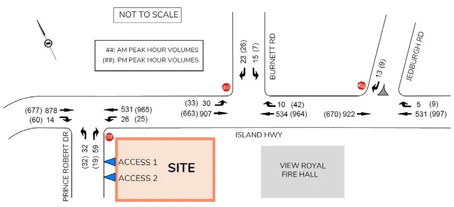
3.6 OPENING DAY POST DEVELOPMENT CONDITIONS
The opening day post-development conditions were analyzed by adding the development trips to background traffic volumes.
At Island Highway / Prince Robert Drive, the northbound movement drops to LOS F in the AM / PM peak hour with the development. A maximum V/C ratio remains at 0.82 for the northbound movement, which does not exceed a general threshold (0.95) for mitigation. The westbound left turn volumes were estimated at 25 / 26 vehicles in the AM / PM peak hour with the development. The estimated westbound left queues increase to unacceptable lengths of 26m / 29m during the AM / PM peak hour; a westbound left turn lane should be considered. The northbound queue length on Prince Robert Drive was estimated at 30m in the AM peak hour which does not block the proposed access (35m spaced from Island Highway).
Based on the 2025 AM / PM post development volumes, a westbound left turn lane is warranted (BC MOTI Warrant manual). A dedicated westbound left turn lane should be installed for safety with the development. Implementation of a westbound left turn lane makes delays at the side street slightly less based on the Synchro result. As an alternative traffic control for Island Highway / Prince Robert Drive, the warrant analysis for a traffic signal is described in Section 5.1.
The proposed development will have little impact on traffic operations at the other two study intersections. At Island Highway / Burnett Road, the stop-controlled southbound movement will drop to LOS E (average delay: 37.4 seconds) with 2-4 seconds of additional delays in the AM and PM peak hours with no queuing issue. The intersection of Island Highway / Jedburgh Road will continue to operate at LOS C or better for all movements in the AM and PM peak hours.
See Table 6 for the results of the analysis. See Figure 6 for the Opening Day post development volumes.
TABLE 6: 2025 OPENING DAY POST DEVELOPMENT CONDITIONS
| INTERSECTION | MOVEMENT | AM Peak Hour | PM Peak Hour | ||||||
|---|---|---|---|---|---|---|---|---|---|
| LOS | Delay (s) | v/c Ratio | Queue (m)* | LOS | Delay (s) | v/c Ratio | Queue (m)* | ||
| ISLAND HWY / PRINCE ROBERT DR (EB/WB=ISLAND HWY) | EBTR | A | 0.0 | - | 5.0 | A | 0.0 | - | 3.1 |
| WBLT | B | 10.7 | 0.06 | 26.4 | A | 9.6 | 0.04 | 29.2 | |
| NBLR | F | 86.7 | 0.82 | 29.6 | F | 102 | 0.74 | 21.5 | |
| ISLAND HWY / BURNETT RD (EB/WB=ISLAND HWY) | EBL | A | 9.0 | 0.05 | 10.5 (20) | B | 10.8 | 0.07 | 13.4 (20) |
| EBT | A | 0.0 | - | 9.6 | A | 0.0 | - | 8.3 | |
| WBTR | A | 0.0 | - | 4.6 | A | 0.0 | - | 7.8 | |
| SBLR | E | 37.4 | 0.37 | 13.3 | E | 37.4 | 0.32 | 15.4 | |
| ISLAND HWY / JEDBURGH RD (EB/WB=ISLAND HWY) | EBT | A | 0.0 | - | 6.3 | A | 0.0 | - | 10.9 |
| WBTR | A | 0.0 | - | 2.1 | A | 0.0 | - | 19.9 | |
| SBR | B | 12.9 | 0.05 | 2.3 | C | 19.0 | 0.05 | 3.5 |
*Note: 95th Queues based on SimTraffic results (averaged from five simulation runs); (##) = Existing Storage Length
4.0 2035 10-YEAR HORIZON TRAFFIC CONDITIONS
For the ten-year horizon analysis, 2035 background volumes were obtained using an annual growth rate of 1.2% from 2022 measured volumes. See Figure 7 for 2035 peak hour background volumes.
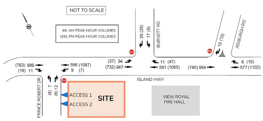
4.1 2035 BACKGROUND CONDITIONS
2035 background conditions were analyzed for the three study intersections. At Island Highway / Prince Robert Drive, the northbound movement is expected to operate at LOS E in the AM / PM peak hour due to high through volumes on Island Highway.
At Island Highway / Burnett Road, the southbound movement will drop to LOS E / F due to high through volumes on Island Highway in the AM / PM peak hour. This degradation in LOS is based on general Island Highway volume increases with little direct impact from the development.
The intersection of Island Highway / Jedburgh Road will continue to operate at LOS C or better for all movements in the AM and PM peak hours. See Table 7 for the results of the 2035 background analysis.
TABLE 7: 2035 BACKGROUND CONDITIONS
| INTERSECTION | MOVEMENT | AM Peak Hour | PM Peak Hour | ||||||
|---|---|---|---|---|---|---|---|---|---|
| LOS | Delay (s) | v/c Ratio | Queue (m)* | LOS | Delay (s) | v/c Ratio | Queue (m)* | ||
| ISLAND HWY / PRINCE ROBERT DR (EB/WB=ISLAND HWY) | EBTR | A | 0.0 | - | 1.3 | A | 0.0 | - | 4.3 |
| WBLT | B | 10.9 | 0.02 | 25.3 | A | 9.6 | 0.01 | 25.0 | |
| NBLR | E | 40.9 | 0.24 | 13.9 | E | 48.6 | 0.26 | 11.4 | |
| ISLAND HWY / BURNETT RD (EB/WB=ISLAND HWY) | EBL | A | 9.1 | 0.05 | 11.8 (20) | B | 11.5 | 0.09 | 15.1 (20) |
| EBT | A | 0.0 | - | 5.9 | A | 0.0 | - | 10.9 | |
| WBTR | A | 0.0 | - | 4.5 | A | 0.0 | - | 11.9 | |
| SBLR | E | 46.3 | 0.46 | 16.5 | F | 55.5 | 0.46 | 18.0 | |
| ISLAND HWY / JEDBURGH RD (EB/WB=ISLAND HWY) | EBT | A | 0.0 | - | 6.2 | A | 0.0 | - | 16.9 |
| WBTR | A | 0.0 | - | 6.2 | A | 0.0 | - | 25.5 | |
| SBR | B | 13.6 | 0.06 | - | C | 21.5 | 0.06 | - |
*Note: 95th Queues based on SimTraffic results (averaged from five simulation runs); (##) = Existing Storage Length
4.2 2035 POST DEVELOPMENT ANALYSIS RESULTS
2035 post development conditions were analyzed by adding the development trips to 2035 background traffic volumes.
At Island Highway / Prince Robert Drive, the northbound movement drops to LOS F in the AM and PM peak hours with the development. The estimated westbound left queues are unacceptable with 48m / 56m in the AM / PM peak hours under the current laning (no left turn lane). A westbound left turn lane should be installed with the development for safety. If a westbound left turn lane was added on Island Highway at Prince Robert Drive, the estimated left queues reduce to 12-13m in the peak hours. At the intersection, the maximum V/C ratio was estimated at 1.02 /1.09 for the northbound movement in the AM / PM peak hour, which exceeds the general mitigation threshold of 0.95. The northbound delay was estimated at 151 / 227 seconds in the AM / PM peak hour. However, even with the 2035 post-development delays, a traffic signal is not warranted as the total estimated delay (3.4 / 3.3 vehicle-hours in AM / PM peak hour) still does not satisfy a threshold delay level (4 vehicle-hours). At the side street, the estimated AM peak hour volume (80 vph) exceeds a threshold volume level (75 vph) for a signal warrant (MOTI’s warrant: peak hour volume). If the actual peak hour volume from the side street exceeds 75 vph in the future, a traffic signal should be considered. Intersection improvements are discussed in Section 5.0.
At Island Highway / Burnett Road, the southbound movement will operate at LOS F in the AM/PM peak hours. However, additional delays caused by the development will be marginal with 6 seconds in the AM peak hour and 3 seconds in the PM peak hour. The intersection of Island Highway / Jedburgh Road will continue to operate at LOS C or better for all movements in the AM and PM peak hours with the development.
See Table 8 for the results of the 2035 post development analysis. See Figure 8 for 2035 post development volumes.
TABLE 8: 2035 POST DEVELOPMENT CONDITIONS
| INTERSECTION | MOVEMENT | AM Peak Hour | PM Peak Hour | ||||||
|---|---|---|---|---|---|---|---|---|---|
| LOS | Delay (s) | v/c Ratio | Queue (m)* | LOS | Delay (s) | v/c Ratio | Queue (m)* | ||
| ISLAND HWY / PRINCE ROBERT DR (EB/WB=ISLAND HWY) | EBTR | A | 0.0 | - | 6.5 | A | 0.0 | - | 3.7 |
| WBLT | B | 11.2 | 0.07 | 48.1 (12) | B | 10.0 | 0.05 | 56.3 (13) | |
| NBLR | F | 151 | 1.02 | 34.5 | F | 227 | 1.09 | 27.6 | |
| ISLAND HWY / BURNETT RD (EB/WB=ISLAND HWY) | EBL | A | 9.2 | 0.05 | 12.2 (20) | B | 11.7 | 0.09 | 15.0 (20) |
| EBT | A | 0.0 | - | 10.5 | A | 0.0 | - | 10.5 | |
| WBTR | A | 0.0 | - | 6.5 | A | 0.0 | - | 9.7 | |
| SBLR | F | 52.5 | 0.50 | 15.9 | F | 58.4 | 0.47 | 20.2 | |
| ISLAND HWY / JEDBURGH RD (EB/WB=ISLAND HWY) | EBT | A | 0.0 | - | 4.9 | A | 0.0 | - | 12.6 |
| WBTR | A | 0.0 | - | 2.6 | A | 0.0 | - | 18.4 | |
| SBR | B | 13.9 | 0.06 | - | C | 21.9 | 0.06 | 1.9 |
*Note: 95th Queues based on SimTraffic results (averaged from five simulation runs); (##) = Existing Storage Length (##) = Estimated queue length with a dedicated left turn lane
5.0 OPERATIONAL CONSIDERATIONS
5.1 SIGNAL WARRANT REVIEW
For Island Highway / Prince Robert Drive, a traffic signal was examined based on peak hour delay and volume (BC MOTI manual). In the peak hours, delays for the northbound left turn movement could extend to one and half minutes or longer; however, the total estimated delay (1.9 / 1.4 vehicle-hours for AM / PM peak hour) for the northbound movement does not satisfy the peak hour period warrant (4 vehicle-hours). From the minor street movement, the AM peak hour volume (78 vph) exceeds a threshold volume level (75 vph) for a signal warrant while the PM peak hour volume (50 vph) does not.
Additionally, the traffic signal was reviewed based on the TAC signal warrant analysis. A traffic signal is not warranted based on the 2025 given the side street volumes and all other traffic data input. As a result of signal warrant review for the intersection (both TAC and BC MOTI’s warrant requirements), a traffic signal is not warranted based on the 2025 post development peak hour volumes and delays. However, traffic volumes / delays monitoring of this intersection should be undertaken to determine appropriate traffic control by the City in the mid-long term.
5.2 IMPROVEMENTS FOR ISLAND HIGHWAY / PRINCE ROBERT DRIVE
According to ICBC crash data, at Island Highway / Prince Robert Drive, five (5) crashes (3 injury type) were reported from 2015-2019. At Island Highway / Burnett Road, there were three (3) crashes reported in the same period even though the Burnett intersection currently has 2.5 times more turning volumes (148 vs 60 during the AM & PM peak hours) than the Prince Robert intersection.
At Island Highway / Prince Robert Drive, the crashes observed are likely the result of roadway geometry issues. The stopping location for traffic turning from Prince Robert Drive has poor sight distance looking to the left (along Island Highway) due to the horizontal curvature and vegetation. The available sight distance was measured at 65m, which just meets TAC minimum stopping sight distance for 50 km/h roadways. The available sight distance does not meet the required intersection sight distance (105m) for left turning vehicles starting from a stop on a 50 km/h, two lane road.
A westbound left turn lane should be considered on Island Highway at Prince Robert Drive. Based on the 2035 post development volumes, the left turn lane would require a 25-35m storage length (MOTI’s warrant chart), however the SimTraffic results show a 15m storage length is needed. Current right of way on Island Highway appears sufficient to implement roadway improvements including a new left turn lane and realignment. If the existing RV Park site (north of Island Highway) is developed in the future, a two-way left turn lane should also be considered to accommodate left turn traffic for both directions.
On Island Highway, traffic conditions for the two intersections (Prince Robert Drive and Burnett Road) are similar; movements from the side streets will be worse (LOS F during peak hours) as the highway through-traffic increases. Signalization for the Prince Robert Drive intersection should be considered if volumes at the side street approach a threshold volume level (75 vph) as the highway through volumes on Island Highway are already high enough with over 1,500 vph (both directions) in the peak hours.
5.3 LEFT TURN LANE
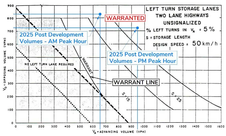
At the Island Highway / Prince Robert Drive intersection, a left turn lane is warranted for the westbound movement based on 2025 opening day post development AM & PM peak hour volumes. A 20m westbound left turn lane should be installed based on the 2025 and 2035 post development analysis results. Implementing a two-way left turn lane should be also considered if the existing RV Park site is developed. See Figure 9 for the left turn lane warrant review.
5.4 FEASIBILITY REVIEW OF ON-STREET PARKING
The feasibility of on-street parking along Island Highway was reviewed. Currently there is no on-street parking provided on Island Highway adjacent to the site. On-street parking typically can lead to reduce road capacity and decrease traffic performance of the certain roads based on related parameters. The feasibility of on-street parking is directly related to the existing road conditions. Traffic volumes and capacity of road are considered key parameters to determine the feasibility of implementation of on-street parking.
Existing traffic volumes along Island Highway are nearly at saturated a condition with 1,500-1,600 vehicles during the peak hours. Particularly for the eastbound movement, significant traffic congestion occurs along the corridor in the AM peak hours. The implementation of on-street parking (parallel parking) could negatively impact road capacity and flow efficiency by increasing side friction under the current congested conditions. Furthermore, on-street parking along the Island Highway frontage would be not suitable due to the limited right-of-way. Significant road cross section improvements are required. A westbound left turn lane should be required on Island Highway and a traffic signal should also be considered at the Price Robert Drive intersection as an alternative traffic control. There is a transit bus stop to be upgraded at the development frontage. The frontage improvements also require a new paved shoulder and wide sidewalk with boulevards to connect to the existing sidewalk network to the east.
These safety/operational changes far outweigh the need for a small number of parking spaces and the friction they will create with the adjacent traffic stream will negatively impact general flow; taken together the parking should not built.
5.5 VEHICLE TURNING MOVEMENT REVIEW
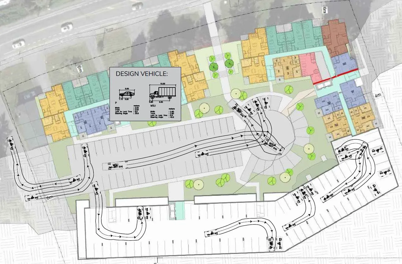
Based on the proposed site plan, vehicle turning movements were reviewed using the AutoTURN program. TAC’s two design vehicles were used: medium size truck (10m length) and passenger vehicle (5.6m length). Two loading zones are proposed for medium size delivery trucks (MSU) at the ground level parking circle. The analysis confirmed that the proposed loading bays are appropriately designed to accommodate medium size delivery trucks. The proposed parking layout also accommodates passenger vehicles properly. See Figure 10 for the vehicle turning movement review.
6.0 ACTIVE TRANSPORTATION
6.1 PEDESTRIANS AND CYCLING FACILITIES
The E&N Rail Trail passes close to the north side of Island Highway within a 300m distance from the site. There are sidewalks along the east side of Burnett Road and along the Fire Department frontage of Island Highway. There are no sidewalks along the development frontage of Island Highway. Based on the ITE Trip Generation Manual, the development (260 multi-family units) will generate 4-5 pedestrian trips during the peak hour. According to the TMP a 2.0m sidewalk with landscaped boulevards is recommended along the development frontage of Island Highway from Prince Robert Drive to the existing sidewalk at the Fire Department. Connection to the pathway could be completed by constructing the sidewalk along Island Highway.
6.2 TRANSIT
The bus route No. 46 passes in front of the proposed site on Island Highway providing service from Langford (Westhills Exchange) to Esquimalt (HMC Dockyard) via the Colwood Exchange two times per peak hours on weekdays. Currently, there is a bus stop at the development frontage on Island Highway. The existing bus stops should be upgraded when the development frontage improvements are made along Island Highway.
7.0 CONCLUSION
The proposed development will generate 96 vehicle trips in the AM peak hour and 101 vehicle trips in the PM peak hour. The development will have little impact on the traffic operations at the two adjacent intersections of Island Highway / Burnett Road, and Island Highway / Jedburgh Road, as the development adds only a small amount of through volume on Island Highway.
The development will impact traffic operations at Island Highway / Prince Robert Drive as significant turning volumes are added to the intersection. With the development the stop-controlled northbound movement will drop to LOS F (2025 opening day background LOS D) in the AM and PM peak hours in the short term. In the long term, the northbound movement will operate at LOS F with additional delays in both the AM and PM hours due to projected increase in through volumes on Island Highway. However, a traffic signal is not warranted based on 2035 post development peak hour volumes and delays, although signalization (or other traffic control) of the intersection should still be considered. At Island Highway / Prince Robert Drive, a westbound left turn lane is strongly recommended as well as a realignment of Island Highway, both of which will improve the intersection safety and operations.
Prince Robert Drive should be upgraded with a paved shoulder along the development frontage. A sidewalk with landscaped boulevards is required along the development frontage of Island Highway to the existing sidewalk at the Municipal Fire Department. Construction of the sidewalk would also complete a connection to the E&N pathway.
On Island Highway, the existing bus stops in front of the site should be upgraded. On-street parking along the Island Highway frontage is not recommended. The two site accesses proposed on Prince Robert are appropriately located from a safety perspective.
8.0 RECOMMENDED IMPROVEMENTS
The following improvements are recommended of the developer:
- Install a 20m westbound left turn lane on Island Highway at Prince Robert Drive.
- Upgrade the cross section of Prince Robert Drive with a paved shoulder along the development frontage.
- Install a sidewalk with landscaped boulevards along the development frontage of Island Highway.
- Upgrade the existing bus stops as per BC Transit and View Royal direction.
The following improvements are recommended of the road authority:
- Consider signalization (or other traffic control) of the Island Highway / Prince Robert Drive intersection in the long term.
- Signalization would be required if the side street volumes reach a signal warrant level.