Committee of the Whole Report: Environmental and Mixed Residential Development Permit - 2379 Lund Road
Staff report regarding a new application to build six townhouses in three buildings at 2379 Lund Road.
TOWN OF VIEW ROYAL
COMMITTEE OF THE WHOLE REPORT
TO: Committee FROM: J. Davison, MCIP RPP Community Planner DATE: March 4, 2021 MEETING DATE: March 9, 2021 FILE NO.: 3060-20-2021-02
ENVIRONMENTAL DEVELOPMENT PERMIT AND MIXED RESIDENTIAL FORM AND CHARACTER DEVELOPMENT PERMIT - 2379 LUND ROAD
RECOMMENDATION
THAT the report dated March 4, 2021 from the Community Planner titled “Environmental Development Permit and Mixed Residential Form and Character Development Permit - 2379 Lund Road” be received for information.
CHIEF ADMINISTRATIVE OFFICER’S COMMENTS
I concur with the recommendation.
DIRECTOR OF DEVELOPMENT SERVICES’ COMMENTS
I concur with the recommendation.
DIRECTOR OF PROTECTIVE SERVICES’ COMMENTS
I concur with the recommendation.
PURPOSE OF REPORT
The purpose of this report is to present a new application for an Environmental Development Permit and Mixed Residential Form and Character Development Permit to build six townhouses in three buildings at 2379 Lund Rd.
BACKGROUND
The application represents the last developable portion of land in the Lund Rd area. The property was subdivided in 2019 to create this portion of the property within the Urban Containment Boundary, zoned as CD-19(B) and mirroring the development pattern of the townhouses to the east on Casey Pl.
PROJECT INFORMATION
The property is 2,748m² and zoned CD-19 (B). The applicant has made application to build six townhouses in three buildings and requires both a Form and Character Development Permit and a Sensitive Terrestrial Environmental Development Permit. The site is a Wildland/Urban Fire Interface zone and the applicant has included an assessment to address that.
- Letter to Mayor and Council – Applicant – February 11, 2021
- Civil Engineering Site Plan – Associated Engineering – January 27, 2021
- Geotechnical Report – Ryzuk Geotechnical - February 8, 2021
- Arborist Assessment – SouthShore Forest Consultants - February 9, 2021
- Landscape Plan – KMZ Landscapes – March 1, 2021
- Block A – C Plans – JAVA Designs – January 25, 2021
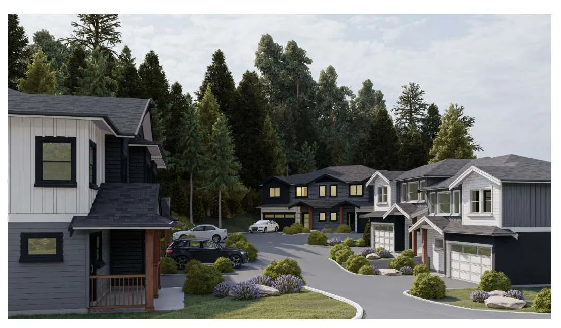
- Project Rendering – Applicant – Undated
- Wildfire Hazard Assessment – Strathcona Forestry Consulting – December 24, 2020
- Project Sustainability Checklist – Applicant - undated
Required Variances
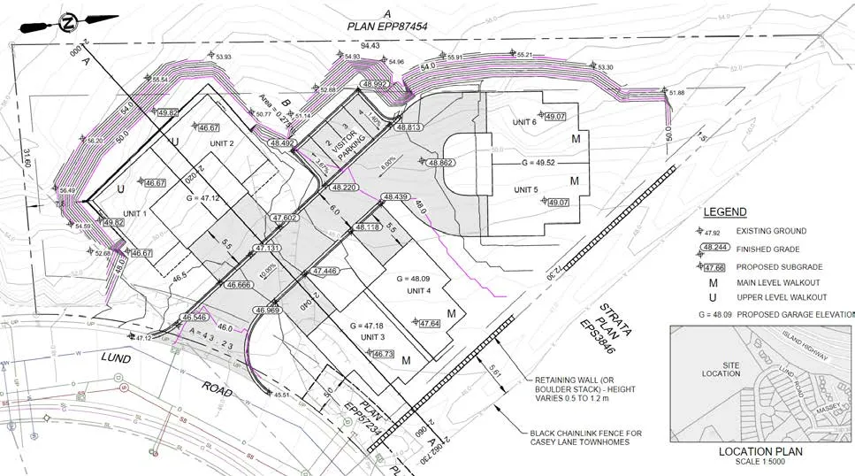
- A variance to define grade as per the included grading plan rather than the definition of Grade within Section 2 of Zoning Bylaw No. 900, 2014
CD-19 Zone Table Comparison
| Regulation | CD-19 (B) Regulation | Proposed |
|---|---|---|
| Site Coverage | 35% | 21% |
| Front Yard Setback | 4.5m | 5m |
| Rear Yard Setback | 6m | 6m |
| Side Yard Setback | 3m | 7.8m, 3m |
| Floor Space Ratio | 0.45 | 0.37 |
| Maximum Building Height | 7.5m | 7.5m (from finished grade) |
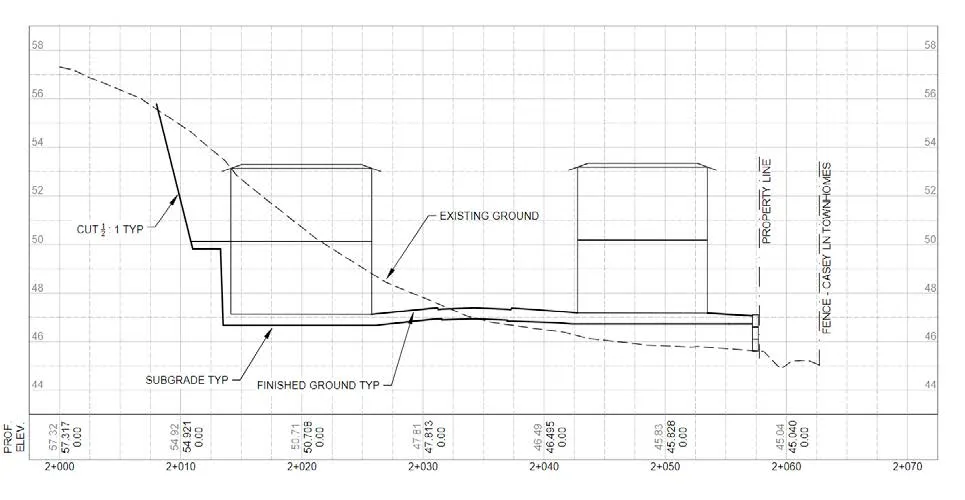
A variance will be required to establish finished grade in the grading plan as grade.
Environment
The applicant has not provided an Environmental Assessment, with the understanding that the site will not retain any natural elements upon completion of development.
Tree Preservation
The applicant has included an arborist assessment.
Our assessment indicates that a number of forest pathogens are active on site. We observed standing dead trees, split, hanging and failed stems with remnant wood decay scattered throughout the site.
Our assessment has indicated that approximately 40% of the trees within this site are struggling and suppressed due to the spread of forest pathogens.
During the assessment we did not observe any form of “Heritage” size tree or specimen of significance to the site. In our opinion the forest is declining due to a number of environmental and cultural conditions.
The proposed development will require the entire site to be demolished and regraded. In this case all trees within the impact zone will be removed.
Two pathogens; Phaeolus schweintziia brown rot which causes butt rot in conifers such as Douglas-fir and Armillaria ostoyaea white root disease which is common to Douglas-fir trees in the Pacific Northwest. Our observations indicate that each of the pathogens are active within the project area.
Post Demolition Period – Visual Tree Risk Assessment – Class “2”
- Provide post demolition inspection of site to determine tree stability and longevity.
- Assess edge trees for further retention and/or removal.
- Provide a written report identifying tree maintenance recommendations for the site.
- Assess and rate impacts to retained trees.
- Provide a remediation tree plan identifying constructive impacts and/or risks associated to tree Protected Root Zone (PRZ).
- Assess slope stability in relation to tree retention and/or removal.
- Provide a Project Arborist certified as a Certified Arborist and Tree Risk Assessor with the International Society of Arboriculture (ISA).
Given the entire site is within Firesmart Priority Zone 1 (10m) the retention of trees at the edge of the site is low-priority, with the maintenance of a fuel-free zone paramount, the health of trees on the boundaries of the development site is still of low importance.
Geotechnical and Site Grading
The geotechnical report describes the work involved to stabilize the site, including the requirement for retaining structures of 1.2m or less. The report outlines their involvement in the process, which will be included as requirements within the Development Permits. Upon completion of site grading works, a geotechnical assessment will be required to certify the site as safe for the intended use. Any cut faces will require an inspection and maintenance plan to be included in this covenant.
Landscape Plan
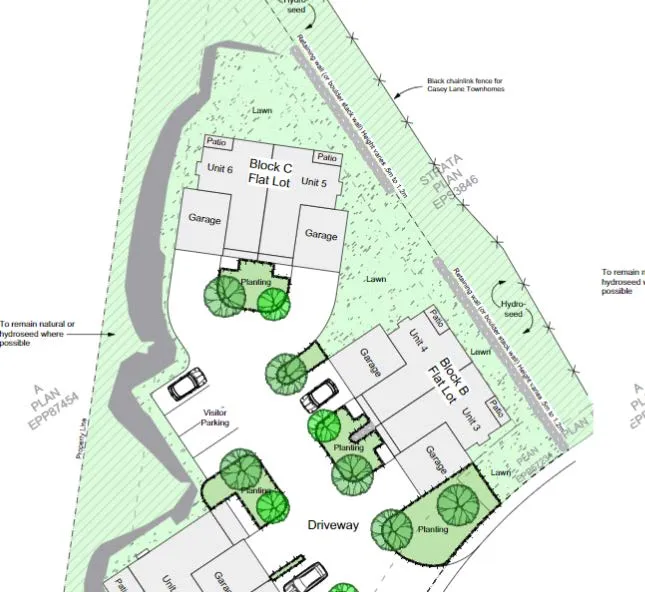
As the site is being cleared of all existing vegetation, the majority of the site will be hydroseeded with grass, or consist of rock outcropping, or be landscaped as shown on the plan. There is a requirement to create a fuel-free zone as per the Firesmart requirements. The appearance of the site is consistent with the rest of the developments along Lund Rd.
The applicant has provided four visitor parking stalls in addition to supplying more parking spaces per unit on-site (2) than is required (1.5).
There are patios in Blocks A and C which project into the required yards. A patio is not considered a structure and therefore does not require a variance.
Mixed Residential (M-R) Form and Character of Development
The applicant has provided renderings of the site and a materials board. The form and character of the site is consistent with the rest of the Lund Rd developments. An assessment of the Mixed Residential Form and Character Guidelines is included in the attachments.
Of note is:
- the requirement for ‘dark skies’ friendly lighting
- natural materials with a general ‘west coast’ design character
- energy-efficiency design following LEED or Built Green standards for design and construction
Wildfire Assessment
The assessment puts the site at a ‘moderate to low-high’ wildfire threat. The Wildfire Risk Reduction recommendations within the Wildfire Assessment will need to be adhered to and will form a part of the Development Permit conditions.
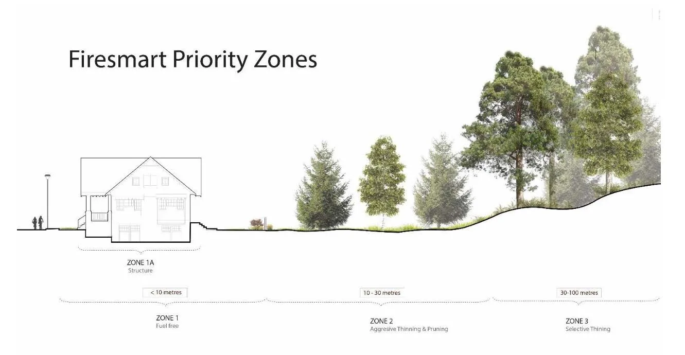
The relevant development permit area guidelines for this proposal relate to interface fire hazard management requirements and are addressed by including the following requirements as conditions of the development permit:
- Keeping 10m low fire fuel areas between buildings and the forest edge
- Use of fire-resistant roofing and cladding materials
- Enclosed metal soffits
- Buildings to be sprinklered
DISCUSSION
The application is consistent with the rest of the development in the immediate area. The proposal covers all the requirements of the applications, with the exception of not providing an Environmental Assessment. Should Council wish to have one completed, it can be included before the item comes to Council.
Staff’s main concern on the site is from a siting point of view. Blocks B and C are very close to the side lot line adjacent to the Casey Lane townhouses, with only a 3m deep rear yard. It is staff’s feeling that pushing the buildings west would improve the conditions on both sides of the fence. There would be greater separation for the existing townhouses on Casey Lane and a more useable rear yard for the new units on this site. This may increase the cut required on the park side to the west, or there could be a site re-design to improve those conditions.
Otherwise, the proposal will blend with the rest of the neighbourhood and round out the development there.
NEXT STEPS
Staff will continue with detailed Development Group review prior to bringing the application forward to Council, especially in terms of being satisfied with the level of detail provided in the grading plan and the wildfire assessment. Staff expects to bring this item forward to Council in April for approval.
RECOMMENDATION
THAT the report dated March 4, 2021 from the Community Planner titled “Environmental Development Permit and Mixed Residential Form and Character Development Permit - 2379 Lund Road” be received for information.
SUBMITTED BY: J. Davison, MCIP RPP, Planner
REVIEWED BY: L. Chase, MCIP RPP, Director of Development Services
ATTACHMENTS:
- Subject Property Map - staff
- Letter to Mayor and Council – Applicant – February 11, 2021
- Civil Engineering Site Plan – Associated Engineering – January 27, 2021
- Geotechnical Report – Ryzuk Geotechnical - February 8, 2021
- Arborist Assessment – SouthShore Forest Consultants - February 9, 2021
- Landscape Plan – KMZ Landscapes – March 1, 2021
- Block A – C Plans – JAVA Designs – January 25, 2021
- Project Rendering – Applicant – Undated
- Wildfire Hazard Assessment – Strathcona Forestry Consulting – December 24, 2020
- Project Sustainability Checklist – Applicant - undated
Document Images
(3)