PLANNING & DEVELOPMENT REPORT - ENVIRONMENTAL DEVELOPMENT PERMIT 2021/16 - 1 MIDWOOD ROAD
Staff report recommending the receipt of an environmental development permit application for a proposed two-lot subdivision.
TOWN OF VIEW ROYAL PLANNING & DEVELOPMENT REPORT
| TO: Committee | DATE: November 5, 2021 |
| FROM: J. Chow, Senior Planner | MEETING DATE: November 9, 2021 |
| FILE NO.: 3060-20-2021-16 |
ENVIRONMENTAL DEVELOPMENT PERMIT 2021/16 - 1 MIDWOOD ROAD
RECOMMENDATION
THAT the November 5, 2021 report from the Senior Planner titled “Environmental Development Permit 2021/16 - 1 Midwood Road” be received for information.
CHIEF ADMINISTRATIVE OFFICER’S COMMENTS
I concur with the recommendation.
DIRECTOR OF DEVELOPMENT SERVICES’ COMMENTS
I concur with the recommendation.
PURPOSE OF REPORT
To introduce a development permit application to permit subdivision of a property partially within the Natural Watercourse and Shoreline Development Permit Area.
BACKGROUND
The 1,396m² property is located on the Portage Inlet waterfront and is zoned R-1B: Detached Residential (Medium Lot). The property has frontages on Midwood Road and Seabird Place as shown in Attachment 1. There is a statutory right-of-way that allows public pedestrian access along the shoreline.
The property was created by consolidation of two lots in 1984. An application has been submitted to subdivide the property back into two lots (Attachment 3). A detached dwelling on the property (see Figure 1) is proposed to be demolished. The subject property and three others between Seabird Place and Portage Inlet are subject to a covenant registered in 1980 requiring a Flood Construction Level of 1.5m above the natural boundary, a setback of 7.5m from Portage Inlet and a setback of 15m from Craigflower Creek. The current 2018 Provincial guidelines for managing flood risks from sea level rise and tsunami hazards are being addressed in the subdivision process.
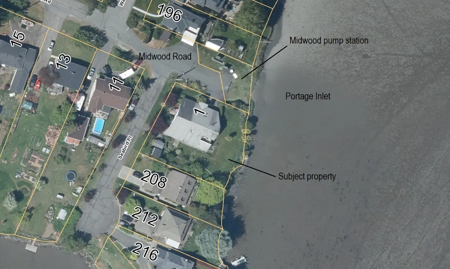
Figure 1. 2021 Air photo
PROJECT INFORMATION
This development permit application has been submitted to permit subdivision of land that is within the Natural Watercourse and Shoreline Development Permit Area. No variances are requested.
The following attachments are provided in support of the application:
- Subject Property Map
- Letter to Mayor and Council, September 24, 2021 (2 pages)
- Subdivision Plan – Wey Mayenburg Land Surveying, September 4, 2021
- Biologist’s report – Swell Environmental, September 24, 2021 (22 pages)
- Landscape Plan – September 15, 2021 (2 pages)
- Geotechnical Report – Ryzuk Geotechnical, August 31, 2021 (5 pages)
Land within the development permit area is highly impacted – it is lawn with some ornamental planting on the periphery as shown in Figures 1-3; however, substantial restoration is proposed (Figure 4). The Biologist’s report notes the following:
- No rare or uncommon wildlife or plant species were observed
- No current bird nesting
- While the riprap along the salt marsh shore and a mortared rock retaining wall are proposed to remain, this site and the surrounding area are good candidates for Green Shores for Salmon shoreline restoration projects
- An underground storm line running across the yard to the Midwood Road storm drain outlet would be installed
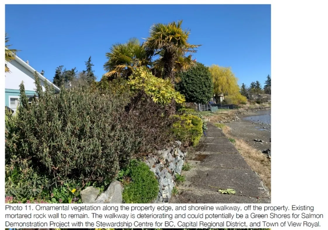
Figure 2. Photo from Biologist’s report
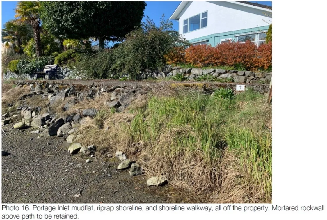
Figure 3. Photo from Biologist’s report
DISCUSSION
Consideration of this application must be based on how it addresses the applicable guidelines of the Natural Watercourse and Shoreline Development Permit Area. The conclusion from the staff review (outlined in Attachment 7) is that the proposal complies with the guidelines, with additional information to be provided on:
- possible impact of grading to address Provincial flood hazard guidelines as part of the subdivision application; and
- how the proposed landscaping would be impacted by potential sea level rise.
Biologist’s Report
The Biologist’s report (Attachment 4) provides recommendations for the following that will be incorporated into the development permit: a. Protecting ecological features including fish and fish habitat b. Requiring a pre-clearing nesting bird survey c. Ornamental and invasive vegetation removal d. Erosion and sediment control from demolition and construction e. Spill prevention and response f. Direction for storm drain installation g. Site restoration h. Environmental monitoring
Landscape Plan
The existing backyard is nearly all lawn. The landscape plan proposes that each lot will retain 95m² of lawn. The remaining 65% of land in the development permit area is proposed to be restored primarily with native plant species as shown in Figure 4 and detailed in Attachments 4 and 5. This is a substantial and positive improvement.
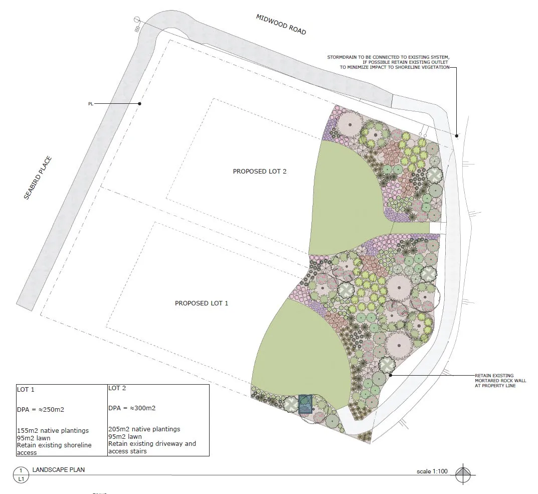
Figure 4. Landscape Plan
Sea Level Rise
Figure 5 shows the potential location of the “Higher High Water Large Tide Line”, meaning part of the yard may become foreshore. It should be confirmed that the proposed landscaping in this area will be compatible with a saltwater marsh environment.
While buildings constructed on the anticipated new lots through this development would be constructed outside the development permit area, which applies to land 15m from the natural boundary, by the year 2100 (target year for the Provincial guidelines and likely nearing the end of the buildings’ lives), the building site for the lot at the Midwood Road/Seabird Place intersection may be partly within the development permit area as sea level rise shifts the natural boundary closer to the building.
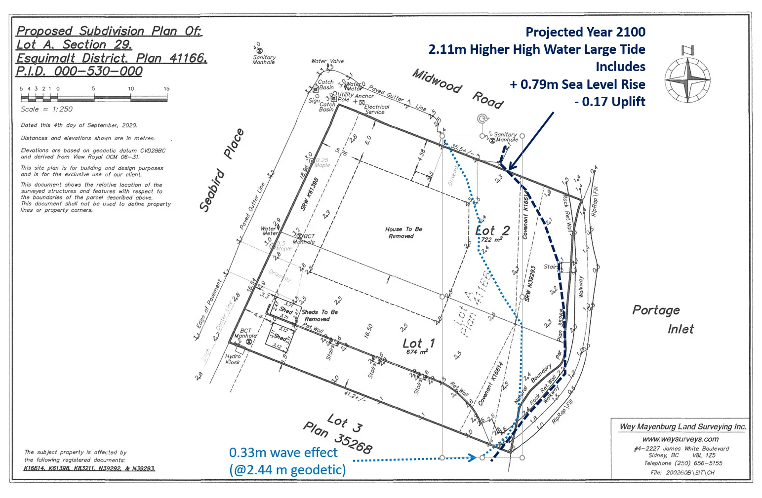
Figure 5. High tide line and wave effect in Year 2100
The Approving Officer will be requiring a grading plan to address Provincial guidelines for flood hazard, identifying how land within the development permit area may be affected.
NEXT STEPS
The application can be considered by Council once information on the following has been provided:
- Information on whether grading to address Provincial guidelines for flood hazards will affect land within the development permit area.
- Confirmation on how land within the development permit area may be affected by sea level rise, i.e., proposed landscaping in this area should be compatible with a saltwater marsh environment.
RECOMMENDATION
THAT the November 5, 2021 report from the Senior Planner titled “Environmental Development Permit 2021/16 - 1 Midwood Road” be received for information.
Document Images
(1)