OFFICIAL COMMUNITY PLAN REVIEW - OCP Public Engagement Update: Parks Wayfinding Strategy Introduction
A presentation introducing a framework for developing a Parks Wayfinding Strategy for the Town of View Royal, based on best practices from Victoria.
PURPOSE OF REPORT
The purpose of this report is to introduce a framework for developing a Parks Wayfinding Strategy for the Town of View Royal. This report emerged as a request from Council as part of the budget process. The initial direction was to do a one-off sign for a park, followed by development of a way-finding strategy.
BACKGROUND
In 2015 the Town added wayfinding signs for cycling and pedestrian linkages to and from the E&N and the Galloping Goose regional pathways. The Town updated the Parks and Trails Guide in 2019.
This report focuses on the options for adding physical signs within parks. In the View Royal Parks Master Plan wayfinding and interpretive signage emerged as an issue to be added or improved upon within parks in View Royal. In the past, Council has also pondered a pathway/trail rating system to be included in information provided on Town maps and signage.
This item was introduced to the Parks, Recreation and Environment Advisory Committee. The PREAC recommendation is as follows:
THAT the Parks, Recreation and Environment Advisory Committee supports the sign typology as presented by the Community Planner for View Royal Parks Wayfinding system.
PROJECT INFORMATION
Adding signs to parks requires identifying clear objectives in balancing two goals: providing a useful amount of information to users while minimizing visual clutter.
There is a variety of information that can be conveyed in a sign within a park:
- Name of park (English name, First Nations name)
- Park regulations (no smoking, hours open, dogs on or off leash, parking restrictions, fire bans, etc.)
- Park features (kayak launch, picnic tables, swimming, playground etc.)
- Mapping (trails, park features, natural areas etc.)
- Interpretive signs (cultural heritage, natural heritage, history, natural processes, wildlife, etc.)
- Directional signs (providing direction and distance to park features)
Providing the above information on signs requires the consideration of the following:
- The type of sign
- The design of each sign
- The location of each sign
Current Signage
View Royal’s current parks signage could be improved.
- There is consistency in the parks naming signs but Town and CRD bylaw information presented in an often visually cluttered way.
- There is a lack of information about park features, mapping, interpretive and directional signage that could assist park users.
- Lack of cultural sensitivity in identifying non-colonial park features, histories and naming.
- The need for significant amounts of signage in the Town is likely reduced by the prevalence of smart phones and the mapping and directional information that is readily available in personal cell phones.
- As per the attached Victoria City Parks Signage document, the standardization of type, design and location makes for consistent, attractive, and predictable messaging within a parks system.
Location of Sign
As part of the recent Victoria City Parks Signage Guidelines public consultation process, the clear consensus among stakeholders is that main arrival points are the most critical areas for signage in parks. Staff believe that similar findings would be made in View Royal.
- Larger parks require more information, and the type of information provided is unique to each park.
- The system by which signs are located can be standardized.
- Wayfinding within parks beyond providing locations of features at main arrival points is only required for parks which are large or difficult to navigate.
- The proposal from staff builds on these best practices to create a standard system of sign location for View Royal parks.
Type of Sign
Staff suggests using the parks classification system from the Parks Master Plan and identifying the need for the type of sign within each park, and which elements are needed on which signs.
The 2017 Parks Master Plan identifies the following park classifications and the parks that fall under that classification:
Community Parks
Neighbourhood Parks
Neighbourhood Greenspace
Natural Greenspace
Shoreline Accesses
Linear Parks
Special Purpose Areas
Community Parks and Natural Greenspaces may require arrival-point information including name, park features, mapping, regulatory, and, sometimes, wayfinding and interpretive signage.
Neighbourhood parks may require less information, and
Neighbourhood Greenspaces may only require naming and some regulatory information.
Special Purpose Areas like Lime Kiln Park may warrant a full interpretive sign with history of the site and additional context.
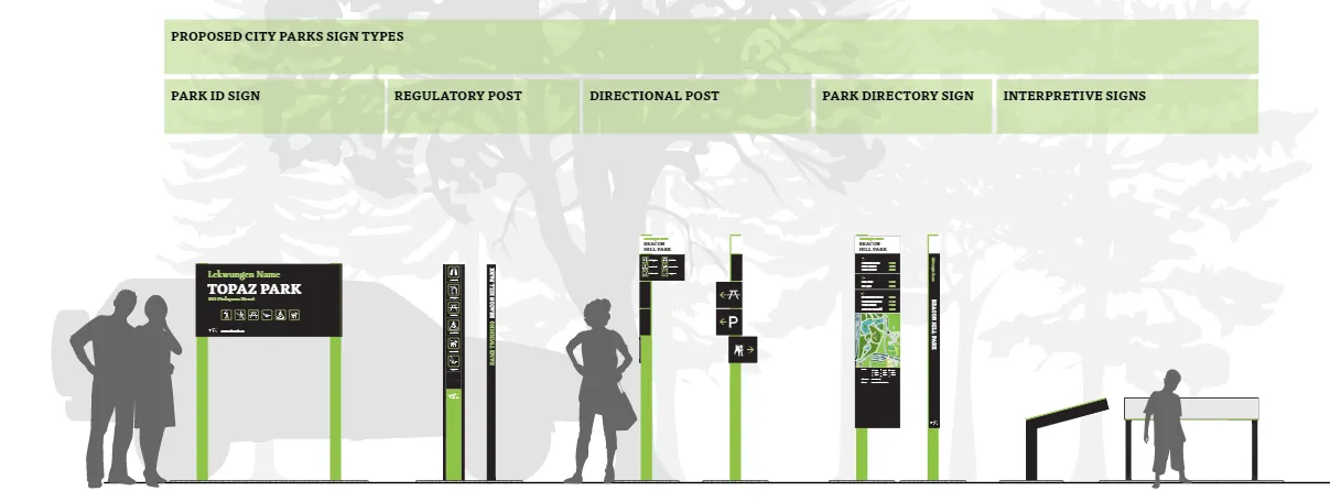
The City of Victoria has outlined very clear sign typologies within their sign document, indicated here:
Design of Sign
Signs should have consistent design and messaging and contain legible fonts and symbols which are designed to be inclusive of a wide audience.
This can include allowances for visually disabled people and colourblind individuals.
The signs would be expected to be View Royal-themed in colour, resistant to vandalism and graffiti, of durable materials, and visually unobtrusive.
Cost of Signs
Staff are working to secure cost estimates for various sign typologies and this will inform budget requests for the 2022-27 Financial Plan.
We note that small operational costs are expected with signs for annual cleaning and maintenance.
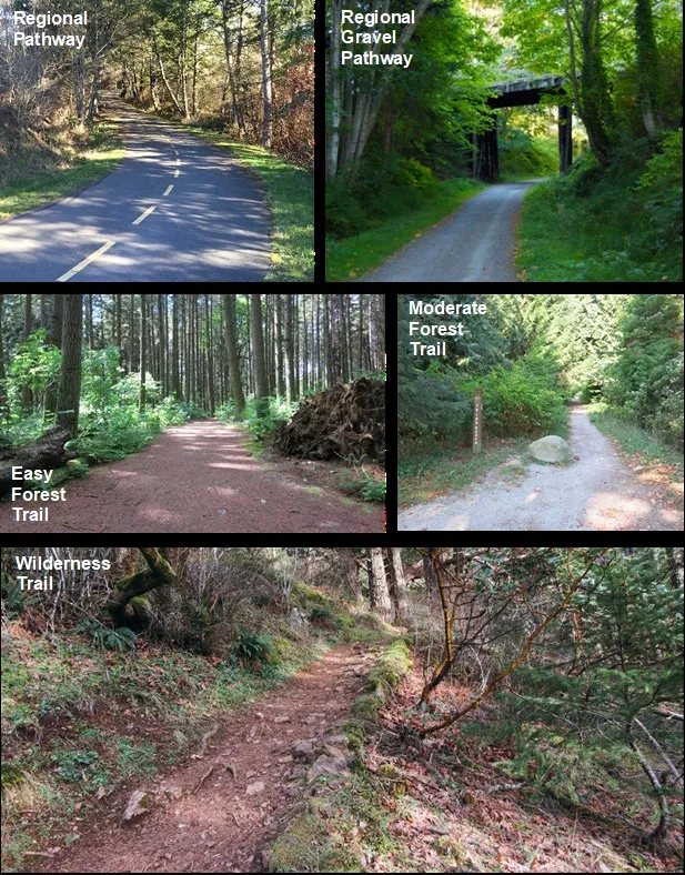
Council may consider adding a trail rating system to the Town’s signage. PREAC has had conversations about this topic in the past. Creating various ratings would assist in determining trail accessibility for all users of the park. A sample framework could be the following (as a starting point, or example):
DISCUSSION
- Staff suggests that a framework for current and future sign standards be created in much the same manner as the City of Victoria’s. In this way, addition of signs in parks can be consistent, predictable, and repeatable for all locations within the Town.
- Consultation with Esquimalt Nation and Songhees Nation could be helpful in determining any applicable First Nations names for the locations.
- The Town may wish to consider contracting external content providers for interpretive signage and this can be included in future budget proposals.
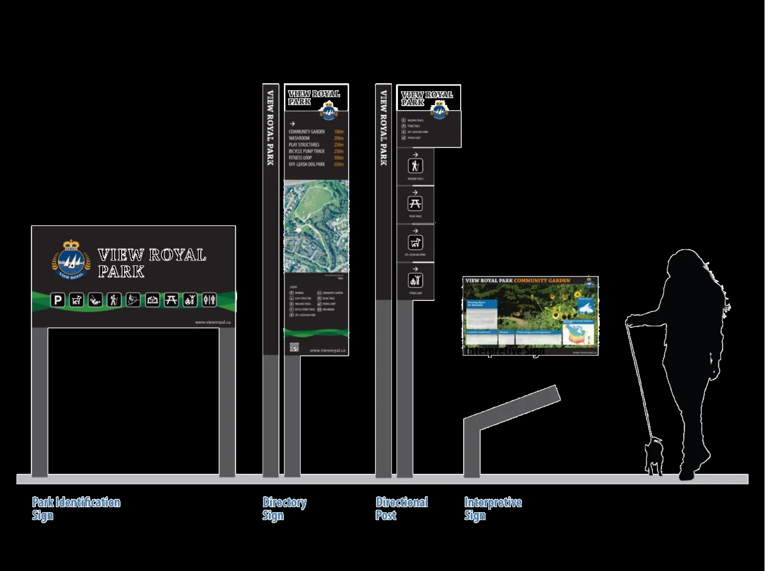
- Attached to the report is a sample sign implementation plan for View Royal Park and for Portage Park.
Directory Sign
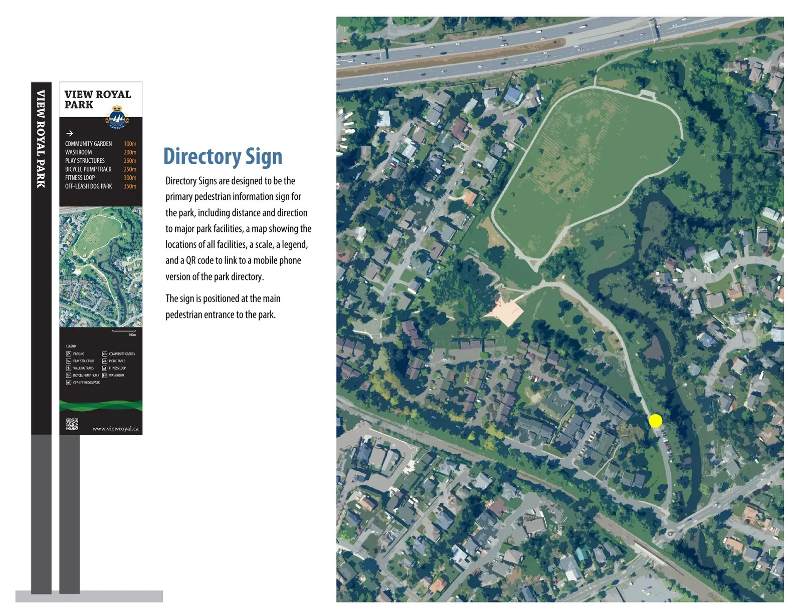
Directory Signs are designed to be the primary pedestrian information sign for the park, including distance and direction to major park facilities, a map showing the locations of all facilities, a scale, a legend, and a QR code to link to a mobile phone version of the park directory.
The sign is positioned at the main pedestrian entrance to the park.
Portage Park Sample Signage
- Directory Sign: Directory Signs are designed to be the primary pedestrian information sign for the park, including distance and direction to major park facilities, a map showing the locations of all facilities, a scale, a legend, and a QR code to link to a mobile phone version of the park directory. The sign is positioned at the main pedestrian entrance to the park.
- Directional Post: Directional Posts are designed to be secondary pedestrian information signs positioned at secondary park entrances and at major decision-making points within the park. The sign will convey the name of the park and directions to those facilities.
- Interpretive Sign: Interpretive Signs are intended to be educational. They provide detailed information about park features, which may be natural history or processes, cultural histories and features, wildlife information, park facilities, or other pieces of interesting or important information. These signs can be various sizes depending on the feature in question.
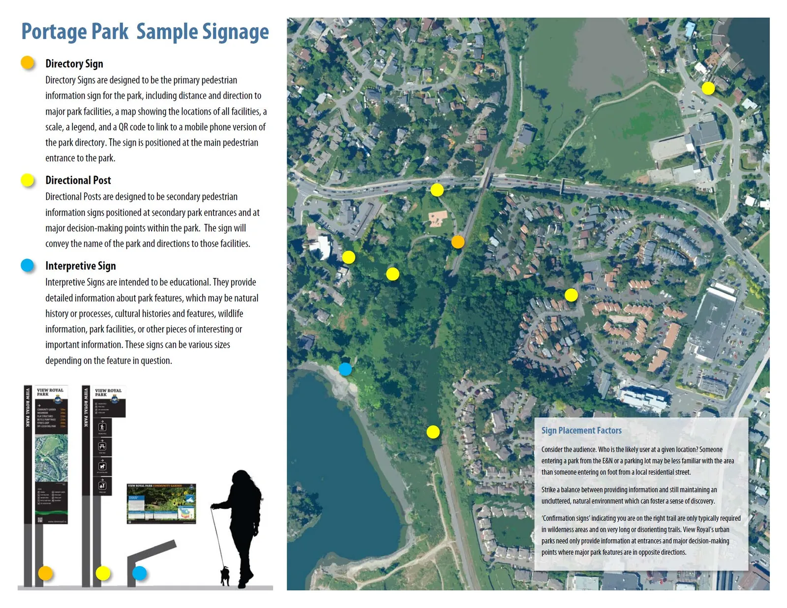
Sign Placement Factors
Consider the audience. Who is the likely user at a given location? Someone entering a park from the E&N or a parking lot may be less familiar with the area than someone entering on foot from a local residential street.
Strike a balance between providing information and still maintaining an uncluttered, natural environment which can foster a sense of discovery.
‘Confirmation signs’ indicating you are on the right trail are only typically required in wilderness areas and on very long or disorienting trails. View Royal’s urban parks need only provide information at entrances and major decision-making points where major park features are in opposite directions.
RECOMMENDATION
THAT Council receive the report dated December 6, 2021 from the Community Planner entitled “Parks Wayfinding Strategy Introduction” for information.
Document Images
(1)