Attachment 7 Traffic Impact Assessment
A traffic impact assessment report for Portage Park Residences evaluating existing and post-development traffic conditions.
PORTAGE PARK RESIDENCES
Traffic Impact Assessment
Author: Tanner Vollema, EIT Reviewer: Nadine King, P.Eng., PTOE Date: July 22th, 2021 File No.: 3100.B01
TABLE OF CONTENTS
1.0 INTRODUCTION ................................................................................................... 1 1.1 Study Area ..................................................................................................................... 1 2.0 EXISTING CONDITIONS ..................................................................................... 2 2.1 Current Land Use ......................................................................................................... 2 2.2 Road Network ............................................................................................................... 2 2.3 Traffic Modelling – Background Information ....................................................... 4 2.4 Existing Traffic Conditions (2021) .......................................................................... 4 2.4.1 Data Collection ............................................................................................... 4 2.4.2 Analysis Results ............................................................................................. 5 3.0 POST DEVELOPMENT ........................................................................................ 7 3.1 Proposed Land Use ..................................................................................................... 7 3.2 Trip Generation ............................................................................................................. 7 3.3 Trip Assignment ........................................................................................................... 8 3.4 Post Development Conditions ................................................................................. 9 4.0 LONG TERM CONDITIONS (2031) ................................................................ 12 4.1 2031 Background Conditions ............................................................................... 12 4.2 2031 Post Development Conditions ................................................................... 15 5.0 ACCESS REVIEW ............................................................................................... 17 5.1 Two-Way Left Turn Lane ....................................................................................... 17 6.0 ALTERNATIVE TRANSPORTATION MODES .............................................. 18 6.1 Pedestrians / Cyclists ............................................................................................... 18 6.2 Transit ........................................................................................................................... 19 7.0 CONCLUSION ..................................................................................................... 19 7.1 Recommendations .................................................................................................... 21
APPENDICES
Appendix A: Synchro Background
LIST OF FIGURES
Figure 1: Site Location and Study Intersections ............................................................................. 2 Figure 2: 2021 Existing Volumes ........................................................................................................ 5 Figure 3: Development Site Plan ......................................................................................................... 7 Figure 4: Trip Assignment ..................................................................................................................... 9 Figure 5: 2021 Post Development Volumes ................................................................................. 10 Figure 6: 2031 Background AM and PM Peak Hour Volumes ................................................ 13 Figure 7: 2031 Post Development Volumes ................................................................................. 15 Figure 8: Proposed Access Location and Two-Way Left Turn Lane .................................... 18
LIST OF TABLES
Table 1: 2021 Existing Conditions ...................................................................................................... 6 Table 2: Trip Generation Summary – AM and PM Peak Hour .................................................... 8 Table 3: 2021 Post Development Conditions ............................................................................... 11 Table 4: 2031 Background Conditions ........................................................................................... 14 Table 5: 2031 Post Development Conditions ............................................................................... 16
1.0 INTRODUCTION
WATT Consulting Group was retained by Urban West Architecture to conduct a Traffic Impact Assessment (TIA) of the proposed Portage Park Residences development located at 167 / 169 / 171 Island Highway in View Royal. The development consists of a 5 storey multi-family residential building with a total of 87 residential units. This report examines the existing and opening day traffic conditions as well as the long term (10 year horizon) traffic conditions, highlights any potential operational issues, and (if necessary) recommends mitigation measures to ensure accommodation of development traffic. The study also includes a site access review and a review of the alternative transportation networks (pedestrian, cycling, and transit) within the vicinity of the site.
1.1 STUDY AREA
The development is located at 167 / 169 / 171 Island Highway in View Royal. The study area includes the following intersections:
- Island Highway / View Royal Avenue
- Island Highway / Helmcken Road
The site location and study intersections are shown in Figure 1.
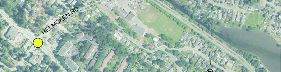
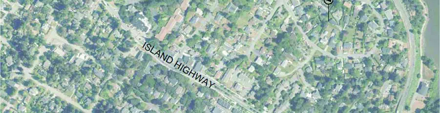
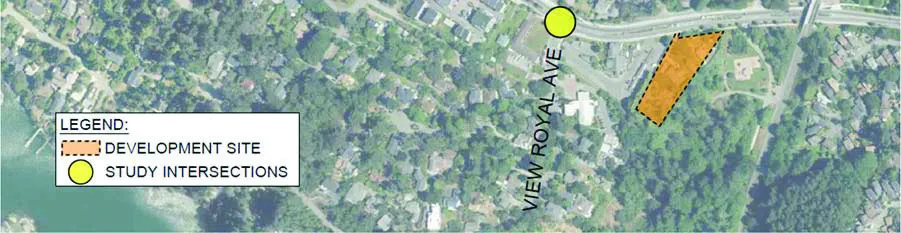
Figure 1: Site Location and Study Intersections
2.0 EXISTING CONDITIONS
2.1 CURRENT LAND USE
The existing surrounding properties are primarily residential (single- and multi-family) along with a park (Portage Park) to the east and a small amount of commercial (retail and restaurant) located on the south-east and south-west corners of the Island Highway / View Royal intersection as well as the View Royal Town Hall located west of the development site.
2.2 ROAD NETWORK
There are three (3) roadways within the study area, as described below:
Document Images
(2)