Appendix B: Councillor Rogers’ Submission
Detailed project descriptions, worksheets, and maps for the seven proposed council initiatives from Councillor John Rogers.
COUNCIL INITIATIVE #1
SUBMITTED BY COUNCILLOR JOHN ROGERS
PROJECT NAME
Develop connectivity Plan assessment criteria to prioritize 5-year rollout of sidewalks, trails, paths.
Was on 2020 wish list too.
PROJECT DESCRIPTION
Establishing objective criteria is critical first step to address orderly implementation of 5-year plan. With this checklist, residents can see when “their” project is likely to occur.
PROJECT LOCATION
Throughout View Royal
ANTICIPATED COST (IF KNOWN)
Time, in-house
PREFERRED YEAR OF IMPLEMENTATION
2021
REQUEST FOR FURTHER PUBLIC CONSULTATION / COMMUNITY INVOLVEMENT
Joint workshop with advisory committees, and community survey
REFERENCE MATERIAL (WEBSITE LINKS, BROCHURES, ETC)
- 1990s Sidewalk Master Plan showed how priorities were established for when work would be done
- 2017 PREAC draft of Trails Assessment Criteria. ATTACHED
- What work already done by other municipalities?
PRIORITY
High
TRAILS EVALUATION CRITERIA
RANKING EACH OUT OF 5…
TRAIL LOCATION /NAME (in what neighbourhood; near what street)
LENGTH / TERRAIN FEATURES ( FLAT, STEEP, THRU ECOLOGICALLY SENSITIVE AREAS
PRIMARY USE TYPE? NARROW AND WILD (.5- 1 M), WIDER FOR SHARED USE (2M), CITY WIDTH (3- 4m). LOCAL OR COLLECTOR?
TRAIL CONSTRUCTION / MAINTENANCE. STAIRS/ RAILINGS / BRIDGES NEEDED? EASY TO MAINTRAIN? ALL SEASON ACCESSIBILITY?
CONNECTIONABILITY? NEIGHBOURHOODS, ACTIVITY CENTRES, SCHOOLS? PARKS, PLAYGROUNDS, BUSINESSES, BUS STOPS, BEACHES, VIEWSCAPES, LINKS TO COMMUTER TRAILS
SAFE AND ACCESSIBLE…. WELL USED, LOTS OF ‘EYES’, GOOD SIGHTLINES, ANY NEARBY STREET LIGHTING
HAS GOOD SIGNAGE (TO LOCATE IT, AND WAYFINDING ON IT), AND INTERPREATIVE … NATURAL FEATURES, CULTURE AND LOCAL HERITAGE, BUT IT SHOULD BE MINIMAL, ATTRACTIVE AND IN GOOD REPAIR…
AMENITIES SUCH AS PARKING (MANDATORY), RESTROOMS (CONVENIENT) WHERE APPROPRIATE
LINKAGE… PART OF A BROADER SYSTEM OF TRAILS THAT CONNECT TOGETHER, AND MAY BE CIRCULAR
GOOD FIT WITH THE NEIGHBOURHOOD? FENCING REQUIRED FOR NARROW LANES IN BETWEEN HOUSES, ENHANCES PROPERTY VALUES,
RECREATION / RELAXATION / VARIATION
ENVIRONMENTAL RESPECT GOOD WATER SETBACKS, AWAY FROM WILDLIFE NESTING, AWAY FROM ECOLOGICAL SENSITIVE AREAS (IF SO, HAS ‘PEOPLE’ BARRIERS, LIKE SPLIT RAIL FENCING
FOSTERS COMMUNITY SPIRIT, INCLUSIVE, NEIGHBOURLY
LIKELY TO BE ADOPTED BY A NEIGHBOURHOOD TO HELP BUILD, MAINTAIN AND PROTECT?
COMMUNITY SURVEY NEEDED??
Town of View Royal Trails Master Plan Working Group
Trail Evaluation Worksheet – DRAFT CHILCO TRAIL TRIAL
DRAFT
Trail Location/Name:_________________________________ Length of Existing Trail:(if applicable) Length of Proposed New Trail:______ Date of Evaluation://__ Time of Day visited:_________
Proposed Trail Type: (Check one)
- Narrow and wild (0.5-1m wide)
- Casual (1-2m)
- Wider for shared use (2m)
- City Width (3-4m)
Will this trail require major infrastructure? (check any that apply)
- stairs
- bridge
- railings
- Other:_______________________________________
Maintenance Access: (check one)
- truck accessible
- smaller vehicle (gator)
- only on foot
Ongoing Maintenance Needs: (circle one)
Low (path clear and safe) Medium High (garbage cans etc.)
Are there privacy concerns for neighbours? YES/NO
If YES, are there extra costs to reduce these concerns?
- fence
- hedge
- re-route trail away from property
- Other:___________________
Environmental Considerations
- Need for water setbacks
- Away from wildlife nesting
- Need for fencing to protect sensitive areas
- Other:_____________________________________
Current Status of this trail: (check one)
- Informal/Unofficial trial (used by people but not formally developed)
- Continuation of an existing trail
- Future Development Commitment: $___________________ (amenity value if known)
- Other__________________________________________________
Possible Hazards:
- steep slopes?
- water hazards
- dangerous trees?
Required Amenities;
- Parking _______ stalls
- Restrooms
- Garbage Cans x ______
- Dog Bag Dispenser x ________
- Signage:
- Wayfinding x _____
- Interpretive x _____
- Map x _______
- Bylaw (dogs/bikes/horses/smoking)x____
- Environmental Protection x _____
- Hazards x______
- Other_______________________________
Connectability: Does this trail create connections to: (check all that apply)
- neighbourhoods
- amenities (shopping, businesses)
- medical services (hospital, clinic etc)
- recreation facilities
- schools
- parks
- playgrounds
- public transit
- other:_______________________________________________
Linkage: Will this trail: (check all that apply and describe if possible)
- create a connection to a broader network (i.e. Galloping Goose, E&N) _________________________________________________
- complete a loop or circular route :_____________________
Accessibility: Is this trail accessible (check all that apply)
- by strollers
- by wheelchairs
- by mobility scooter
- in all weather conditions
- [ ]
Are there unique features that this trail will offer residents?
- viewpoint
- intact ecosystem (real nature)
- other:________
Estimated current use: (circle one)
Low Medium High
Estimated future use: (circle one)
Low Medium High
How many people did you see in the area during your visit?
Adults: Kids: Dogs:
Do you have any comments about the worksheet or evaluation process:
Do you feel that this trail is a good fit for the neighbourhood?
Any other comments or notes:
*We appreciate you sharing any pictures that you may take on site – please text them to Jen at 250-813-1713 with the location so they can be used in the Trails Master Plan document.
COUNCIL INITIATIVE #2
SUBMITTED BY COUNCILLOR JOHN ROGERS
PROJECT NAME
Finish / implement the Wayfinding Signage project for parks / trails. On 2020 list.
PROJECT DESCRIPTION
View Royal Park, Portage Park, Eagle Creek park, Nursery Hill, Chilco Trails, Portage Trail all still do not have wayfinding signage for residents and visitors. Quick hit, do not need time consuming branding. Town map not good enough and not everyone has a smart phone with them.
(I could not find this on the Activity List either).
PROJECT LOCATION
Throughout View Royal
ANTICIPATED COST (IF KNOWN)
Time and materials
PREFERRED YEAR OF IMPLEMENTATION
2021
REQUEST FOR FURTHER PUBLIC CONSULTATION / COMMUNITY INVOLVEMENT
Joint workshop with advisory committees, and community survey
REFERENCE MATERIAL (WEBSITE LINKS, BROCHURES, ETC)
- MANY excellent template examples through region
- PREAC 2017 draft attached
PRIORITY
High
COUNCIL INITIATIVE #3
SUBMITTED BY COUNCILLOR JOHN ROGERS
PROJECT NAME
Fund fish forage beach along north shore of Portage Inlet. On 2020 list. We will soon have costs.
PROJECT DESCRIPTION
Peninsular Streams is proposing to place sand & gravel materials along shoreline next to Hospital Creek and the boat launch area of Portage Linear Park. This material allows fish species to lay eggs, contributing to the overall biodiversity to local ecosystem. Benefits include mitigation for sea level rise, and recreational boat launch.
Forage fish beach project has been done at Pat Bay.
PROJECT LOCATION
Potions of Hospital Creek and Portage Linear Park
ANTICIPATED COST (IF KNOWN)
Time and materials will be presented to Council
The beach is not only ideal for fish habitat, it is excellent as a public beach; paddling and swimming.
The costs are FAR less than the Shoreline Access ramp, designed for emergency access by protective services
PREFERRED YEAR OF IMPLEMENTATION
2021
REQUEST FOR FURTHER PUBLIC CONSULTATION / COMMUNITY INVOLVEMENT
- Pilot study underway with strong local neighbourhood support / buy in
- DFO has given approval for pilot as well
REFERENCE MATERIAL (WEBSITE LINKS, BROCHURES, ETC)
- Forthcoming from Peninsula Streams
PRIORITY
High
COUNCIL INITIATIVE #4
SUBMITTED BY COUNCILLOR JOHN ROGERS
PROJECT NAME
Hospital Trail Project. Was on 2020 wish list… let’s really do it for the community
PROJECT DESCRIPTION
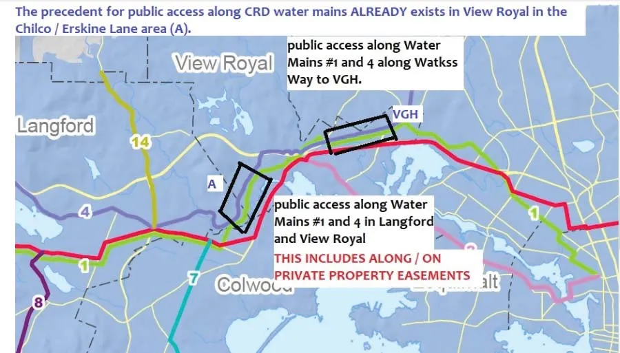
The Water ROW from Erskine Lane and Hospital Way is very popular with local residents. Those who work at VGH, walk dogs, quick access to major transit hub. While wide with great sightlines, it is rocky and uneven. It is also dark at night, an issue for vulnerable people.
PROJECT LOCATION
The Water ROW from Erskine Lane and Hospital Way
ANTICIPATED COST (IF KNOWN)
#9 willing to improve their ‘section’ with road base and lighting on their property
#2 lobby negotiations…. Town improvements needed
PREFERRED YEAR OF IMPLEMENTATION
2021
REQUEST FOR FURTHER PUBLIC CONSULTATION / COMMUNITY INVOLVEMENT
- DONE! DONE! High priority by Erskine Lane, Stoneridge and future #9 residents
- Precedence set with CRD Water years ago with Chilco / Lanford trail parallel to E&N
REFERENCE MATERIAL (WEBSITE LINKS, BROCHURES, ETC)
- See attached image
PRIORITY
High
COUNCIL INITIATIVE #5
SUBMITTED BY COUNCILLOR JOHN ROGERS
PROJECT NAME
Nursery Hill Bryon Road Trail. Was on 2020 list….
PROJECT DESCRIPTION
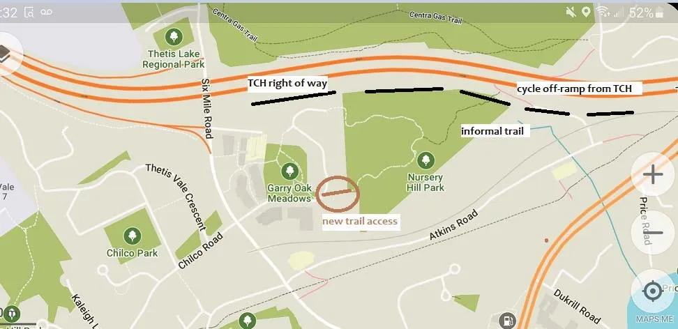
Complete the informal trail that connects Galloping Goose Trail through Nursery Hill Park to 6 Mile, then either to the Calypso Trail to Mill Hill Regional Park, or Chico Trail system up to Edwards Park and into Langford. This trail was envisioned as part of the overall trail system, and still valid.
PROJECT LOCATION
From the east lower end of the existing circular trail down to the cycling ramp from TCH to Bryon Road, then to the Galloping Goose Trail Atkins Rest area.
ANTICIPATED COST (IF KNOWN)
3 deliverables… culvert to enable all weather crossing of TCH storm water ditch, improve path on the berm there, and erect a concrete / post hand rail up / down the slope.
PREFERRED YEAR OF IMPLEMENTATION
2021
REQUEST FOR FURTHER PUBLIC CONSULTATION / COMMUNITY INVOLVEMENT
Requires MOTH approval for trail on TCH right of way. Precedent already set with trails on TCH berms at Helmcken Overpass to VR Park and to Chancellor Park.
REFERENCE MATERIAL (WEBSITE LINKS, BROCHURES, ETC)
See attached image
PRIORITY
High
COUNCIL INITIATIVE #6
SUBMITTED BY COUNCILLOR JOHN ROGERS
PROJECT NAME
Chilco / 6 Mile Dog Off-Leash Project. New for 2021
PROJECT DESCRIPTION
Build one or more dog off-leash areas in this neighbourhood. Many dogs live there, and Thetis Lake is too busy, and not walkable for all. View Royal Park is too far… requires a car. More dogs, more outdoors as result of covid. This is a “community ask”.
PROJECT LOCATION
Island Highway / 6 Mile to Thetis Lake… Atkins to Langford Border
ANTICIPATED COST (IF KNOWN)
Chain link + posts, signage, dog bag dispenser, garbage can
PREFERRED YEAR OF IMPLEMENTATION
2021
REQUEST FOR FURTHER PUBLIC CONSULTATION / COMMUNITY INVOLVEMENT
- Conduct on-line survey like we did for VR Park Bike Park in Winter
- Hold Open House like we did for VR Park Plan review in Spring. Even virtual on-line…
- C76-20 was tabled in June… let’s please “untable” and engage with residents
REFERENCE MATERIAL (WEBSITE LINKS, BROCHURES, ETC)
- Documented lobby /petition by residents who are expecting results
PRIORITY
High
COUNCIL INITIATIVE #7
SUBMITTED BY COUNCILLOR JOHN ROGERS
PROJECT NAME
Atkins Sidewalk Project. New for 2021
PROJECT DESCRIPTION
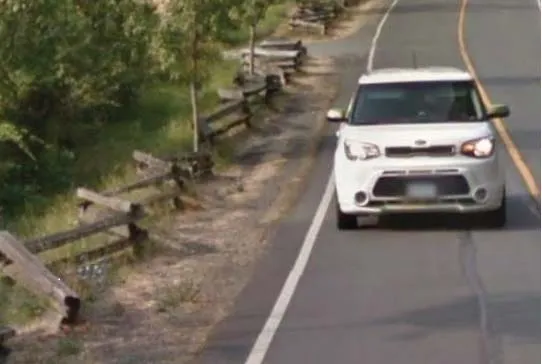
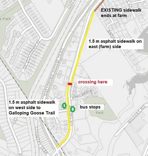
Very unsafe, difficult with young children, strollers and for seniors. Walking to Galloping Goose Trail is dangerous! This does NOT have to be Burnett Road concrete but Watkiss Way asphalt 2 m sidewalk + curb. When Pollock farm is developed, then consider boulevard standards.
So obvious, we do not need to wait any longer for re-development or any master plan.
PROJECT LOCATION
Atkins Road from Anya Lane to Galloping Goose Trail.
ANTICIPATED COST (IF KNOWN)
- To design the 2m ASPHALT sidewalk, identify drainage issues, rights of way, road width and sidewalk needs to be on the north side after Myra Place
- Contract out to build
Use Gas Tax funding for #1
PREFERRED YEAR OF IMPLEMENTATION
2021 for design phase
REQUEST FOR FURTHER PUBLIC CONSULTATION / COMMUNITY INVOLVEMENT
Design it and hold a virtual open house via teleconference
REFERENCE MATERIAL (WEBSITE LINKS, BROCHURES, ETC)
- Documented lobby by residents expecting their safety concerns to be met.
- Images attached
PRIORITY
High