Report to Committee of the Whole: OCP 2020/01 & Rezoning 2020/04 – 298 Island Highway
Staff report regarding an OCP amendment and rezoning application for a mixed-use development at 298 Island Highway.
Unit Mix
The proposed residential unit mix is as follows:
- 16 one-bedroom units
- 37 two-bedroom units
- 1 three-bedroom unit
Building Height
The building is proposed to be 20.3m and six storeys as measured from the base of the building. The final heights from (calculated) average grade would be finalized at time of Development Permit.
Official Community Plan Context
The subject property is within the Helmcken-Harbour Community Corridor which separates the Helmcken and Harbour Neighbourhoods. The proposal is consistent with OCP policy LU9.1 (Attachment 10) for the specific corridor as follows:
- Mixed-use intensification and public space improvement would be concentrated at the Helmcken Intersection.
- The applicant’s concept for a neighbourhood grocery/deli is consistent with the policy that commercial uses should be neighbourhood-serving and limited to properties located near the Helmcken Intersection.
- Right-of-way conditions and pedestrian safety, including connections across the Island Highway and Helmcken Road.
- The proposal would provide a high-quality built environment. The building and pedestrian plaza would become a landmark for this neighbourhood centre.
- Strong and safe connections would be provided to surrounding residential areas, the waterfront, Helmcken Road, View Royal Elementary School and the planned Town Centre.
- Higher residential densities fronting the Island Highway are supported.
- The proposed commercial use would complement and not compete with the future Town Centre and would not inhibit eventual development of the Town Centre desired for the Fort Victoria site.
The policy also states consideration should be made on whether the mixed-use intensity would be appropriate for the corridor’s lots sizes and adjacent residential areas. The proposal may seem dense relative to lot area as shown in following table, but the massing is terraced building form. The impact on the proposed number of units and not significant.
| Development | Address | Units | Lot Area | Units per hectare |
|---|---|---|---|---|
| Current proposal | 298 Island Highway | 54 | 0.1853 ha | 291.4 |
| Lions Cove | 288/290 Island Highway | 66 | 0.8275 ha | 80.0 |
| Maia London | 280 Island Highway | 37 | 0.1677 ha | 220.6 |
| <DP approved, not built> | 242-244 Island Highway | 37 | 0.1860 Ha | 198.9 |
The current land use designation is Neighbourhood Mixed Use, which supports commercial uses with townhouses and apartments up to four storeys with a maximum Floor Space Ratio of 1.5:1. A new Comprehensive Development Area land use designation would be created for the development concept with a maximum FSR of 3.0:1. If Council considers the development proposal to be too dense, the existing Intensive Mixed Use land use designation could be an alternative that permits commercial and residential uses with a maximum FSR of 2.5:1. The proposal would need to be amended to meet the density limits of this land use designation.
The Local Government Act has requirements for early and ongoing consultation of Official Community Plan amendments. In this case Council should give consideration to whether or not early and ongoing consultation is needed given that this is a site specific proposal. The application was referred to the relevant agencies as part of the application review process with no major concerns noted. It is recommended if the application moves forward to a public hearing, that the agencies be formally notified of the amendment bylaw in conjunction with the public hearing process.
Proposed Zone
Rezoning of this site is supportable, subject to a successful Official Community Plan amendment. It complies with the OCP policies encouraging the growth of the Helmcken-Harbour Community Corridor. If the development concept is supported, staff would prepare a new site-specific commercial/residential zone that would be consistent with the proposed OCP land use designation and would accommodate the density, building height and siting of the proposal.
Design comment
While the form and character of the development would be addressed at the development permit stage, the application provides a level of detail in the development concept that illustrates their intent, Council will formally review the form and character of the project when considering the Development Permit.
Stepping back the upper two floors of the building will reduce massing and provide a human scale at the street level. The terraced and articulated facade is a complementary interface to the adjacent Lion Cove Apartment and the taller building at a lower starting grade will provide a consistent skyline. A line of trees is proposed to provide some screening for adjacent residential properties on Eltham Road that have Neighbourhood Mixed Use OCP land use designations and are zoned commercial. The proposed public plaza in and along the Island Highway frontage would create a vibrant pedestrian-oriented street realm.
Community Amenity Contribution
The Community Amenity Contribution Policy target rate is $3,500 per multifamily residential unit to be provided prior to building permit issuance. For this proposal, the contribution would be $189,000 based on 54 units. It is recommended that the community amenity contribution provision rate be secured in a covenant.
OCP Policy HS1.4 Housing Amenity Contributions also supports a housing amenity contribution to the Town, which could be directed to the CRD Regional Housing Trust Fund. A portion of the cash community amenity contributions could be used for this purpose.
An eastbound transit stop across the street (Island Highway at Helmcken Road Stop ID 101050) provides service on the high volume 14 UVic and 46 Dockyard routes. The current shelter is considered suitable for the current volume of ridership (weekday average of 116 boardings and 28 alightings). A T-4 shelter (i.e. high volume) is required when boarding exceeds 400 per average weekday. Upgrading this shelter using CAC funds would be a benefit for neighbourhood transit users.
Transportation Impact
There would be a right-in/right-out vehicle access on each frontage. The Engineering Department comments on the Traffic Impact Assessment (Attachment 8) are as follows:
- The study examined the Town’s 2017 traffic counts and conducted another count in June 2020. The more recent counts may have been influenced by summer, the COVID-19 pandemic, and the construction of the Trans Canada Highway / McKenzie interchange and may be atypical.
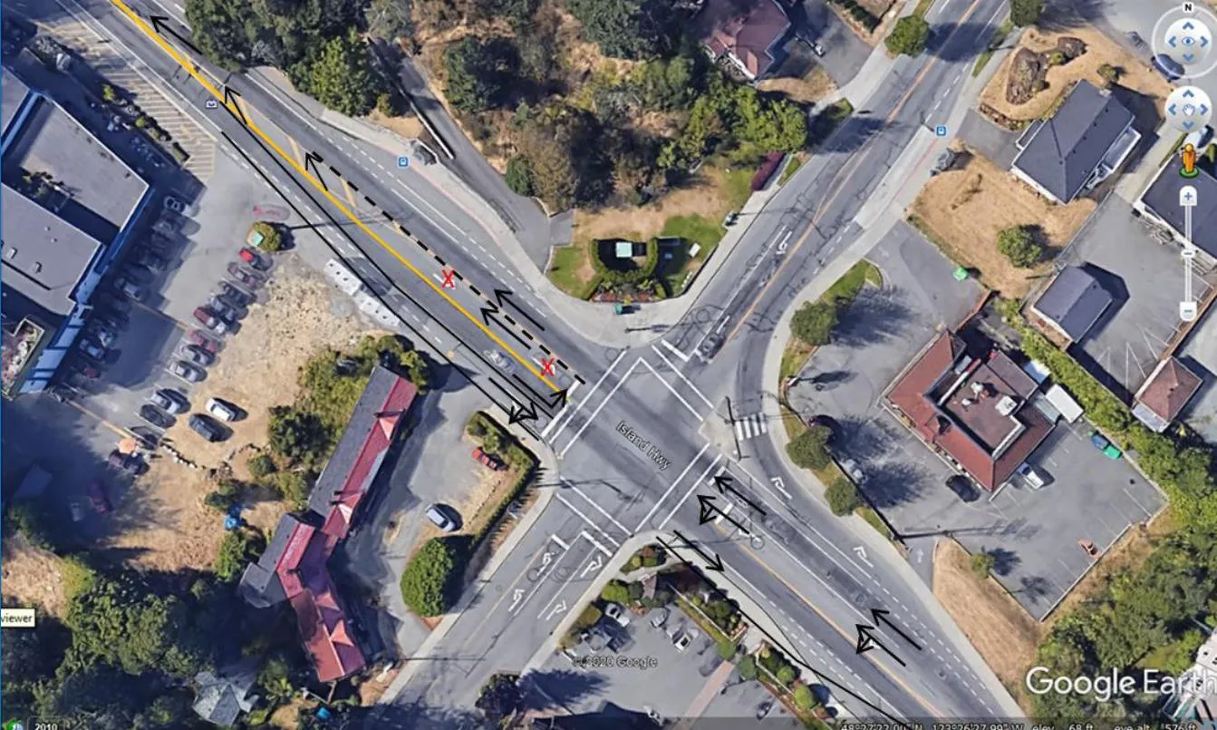
- The Town has designed and created a future plan for the redevelopment of Island Highway from Helmcken to Beaumont. It does not appear that the development has recognized this future design in their reconfiguration of the intersection. The Traffic Impact Assessment proposes reconfiguration of lanes on Island Highway through the Helmcken Road intersection to move more vehicles through. More detail is needed on how it would be achieved and the impacts on existing bike lanes and sidewalks. The suggested alteration of adding a merge lane west of the intersection would appear problematic and commentary is needed on how this impacts traffic flow.
- Analysis should be provided on the consequences of restricting left turn movements and commercial truck access in/out of the site
- Information on bicycle parking, or Transportation Demand Management initiatives should be provided.
BC Transit indicates that the proposed land uses are consistent with the Frequent Transit Network (FTN) corridor and supports continued redevelopment on Island Highway because it would grow ridership and in turn, be supported with increased service levels.
There is a two-seat transit shelter (see Figure 3) at the stop along the Helmcken Road frontage (northbound Helmcken Road at Island Highway Stop ID 101051) for the 14 Vic General route. BC Transit supports an upgrade to a T-3 type (i.e. moderate volume) shelter at this stop as the development can be expected to produce an increase in ridership at this stop.
Site Servicing
The requirements of Subdivision and Development Servicing Bylaw No. 985, 2017 include provision of sidewalks along the site frontages, no net increase in post-development site runoff, and that storm water entering the Town’s drainage system will meet the requirements of Storm Water Regulation Bylaw No. 902, 2015. The Servicing Concept (Attachment 9) estimates the expected sewer flow from the proposed development, but pump station capacity will need to be confirmed.
Public Engagement
The applicant canvassed adjacent properties and conducted an open house with area residents in May. Comment letters are provided in Attachment 4.
ANALYSIS AND DISCUSSION
The proposed uses generally align with OCP policies of the Helmcken-Harbour Community Corridor. An OCP amendment is required because the proposed density is significantly greater than the existing Neighbourhood Mixed Use land use designation. A new Comprehensive Development Area land use designation is requested to permit an FSR of 3.0:1. A site specific zone would be prepared to facilitate the development concept.
Stepping back the upper two floors will give the building human scale. The terraced and articulated massing will provide complementary interface to the adjacent Lions Cove apartments. Trees are proposed to provide some screening for adjacent residential properties on Eltham Road that have Neighbourhood Mixed Use OCP land use designations and are zoned commercial. The proposed public plaza in and along the Island Highway frontage would create a vibrant pedestrian-oriented street realm. Further design consideration will be available to Council at the Mixed Residential Form and Character Development Permit stage.
Next Steps
Subject to comments from the Committee, staff will continue to work with the applicant to resolve the following items prior to preparing bylaws for consideration:
- Confirmation of sewer pump station capacity
- Traffic Impact Assessment comments
RECOMMENDATION
THAT the September 9, 2020 report from the Senior Planner titled “Official Community Plan Amendment Application 2020/01 and Rezoning Application 2020/04 – 298 Island Highway” be received for information;
AND THAT Council requires early and ongoing consultation of the Official Community Plan amendment;
AND FURTHER THAT notification to BC Hydro, BC Ministry of Transportation and Infrastructure, BC Transit, Canada Post, Capital Regional District, Esquimalt First Nation, FortisBC, School District No.61, Shaw Cable, Songhees First Nation, and Telus be made of the public hearing for the proposed Official Community Plan amendment bylaw.
SUBMITTED BY: J. Chow MCIP RPP, Community Planner REVIEWED BY: L. Chase MCIP RPP, Director of Development Services
ATTACHMENTS:
- Subject Property Map
- Subject Property Orthophoto
- Letter from Applicant, May 27, 2020 (13 pages)
- Open House - Letters (22 pages)
- Design Rationale - Ankenman Marchand Architects, (3 pages)
- Architectural Drawings – Ankenman Marchand Architects, June 17-Aug. 31, 2020 (35 pages)
- Landscape Plan - Lombard North Group, June 12, 2020
- Traffic Impact Assessment – Addoz Engineering Inc. – July 9, 2020 (36 pages)
- Water, Storm and Sanitary Review - JE Anderson, August 27, 2020 (20 pages)
- OCP excerpt: Policy LU9.1 Helmcken-Harbour Community Corridor
Document Images
(1)