REZONING INTRODUCTION – 1449 Burnside Rd (Eagle’s Nest)
Staff report introducing the rezoning application for the Eagle's Nest property, outlining the site context, proposed density, and development considerations.
TOWN OF VIEW ROYAL COMMITTEE OF THE WHOLE REPORT
TO: Committee of the Whole DATE: November 6, 2018 FROM: J. Davison, MCIP Planner MEETING DATE: November 13, 2018 FILE NO.: 3360-20-2018-09
REZONING INTRODUCTION – 1449 Burnside Rd (Eagle’s Nest)
RECOMMENDATION
THAT Committee receive the report from the Planner entitled "REZONING INTRODUCTION – 1449 Burnside Rd (Eagle’s Nest)” dated November 7, 2018 for information.
CHIEF ADMINISTRATIVE OFFICER’S COMMENTS
I concur with the recommendation.
DIRECTOR OF DEVELOPMENT SERVICES’ COMMENTS
I concur with the recommendation.
DIRECTOR OF ENGINEERING’S COMMENTS
I concur with the recommendation.
DIRECTOR OF PROTECTIVE SERVICES’ COMMENTS
I concur with the recommendation.
PURPOSE OF REPORT
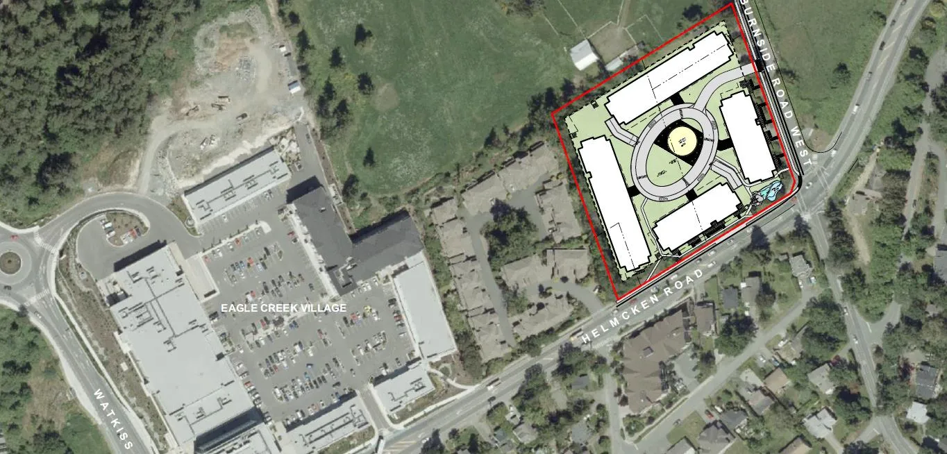
The purpose of this report is to introduce an application to rezone the Burnside Helmcken properties at 3, 5 and 9 Helmcken and 1449 Burnside Rd, henceforward known as the ‘Eagles Nest’ property.
BACKGROUND
Site Context
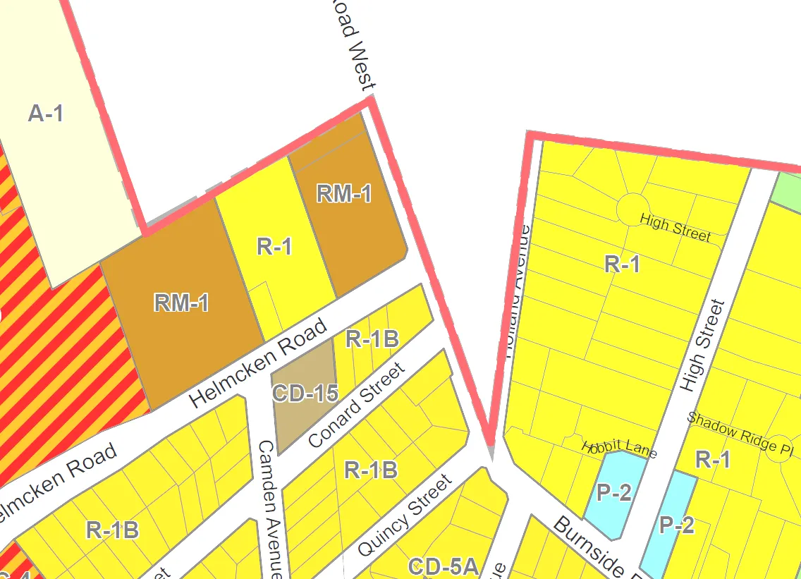
Eagle’s Nest is a 13,800m² (3.41 acre) site at the western corner of Burnside and Helmcken Rd in View Royal. It is within the ‘Northern Gateway’ area of the Hospital neighbourhood in the Town’s Official Community Plan Bylaw No. 811, 2011:
Also referred to as North View Royal, the Hospital Neighbourhood serves as the northern gateway to the Town. The regional draw of VGH brings thousands of people to the neighbourhood each day. While most new development in the Hospital Neighbourhood has been in the form of incremental residential infill, the planned Northern Gateway Community Corridor and Hospital Neighbourhood Centre anticipate the development of higher density housing and other uses that will benefit from and support VGH and the regional rapid transit stop (planned near Helmcken Road and the Trans-Canada Highway).
Opportunities to create a stronger north-south pedestrian and cycling connection between the Hospital and Helmcken neighbourhoods are supported in the OCP.
Zoning Context
The property is zoned half R-1: Detached Residential (Large Lot) and half RM-1: Ground-Oriented Multiple-Unit Residential within Zoning Bylaw No. 900, 2014. The R-1: Detached Residential permits a detached residence at a minimum of 1000m² lot size. The RM-1 zone permits a range of residential uses from detached residential to townhouse residential, at a maximum building height of 7.5m and a base density of 0.6 Floor Space Ratio (FSR).
OCP Context
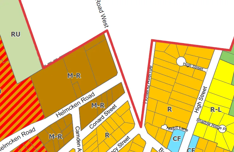
The OCP designates the site as M-R: Mixed Residential which is described as:
Small lot detached houses, townhouses and low-rise apartments up to 3 storeys and 1.25 FSR, and up to 4 storeys and 1.6 FSR for apartment dwellings.
One DP Area regulates the form and character of multi-family residential development, which includes building and landscaping design and materials:
- Mixed Residential Form and Character (across entire site)
Design approval would be considered in a separate Development Permit application after the rezoning application is concluded.
The application as presented is consistent with the Official Community Plan, which means that the use and the density are consistent with the Mixed Residential land use designation. The height of the tallest proposed building is proposed as 6 storeys rather than the stated 4 storey maximum within the land use designation, but this is not considered to be a use or density issue.
Transportation Context
The site is close to the Trans-Canada Highway to the south. An alternative transportation option exists in the Galloping Goose Regional Trail running just north of and parallel to said highway.
The site is on the border of the CRD and Town urban growth (containment) boundary, with Saanich and rural/ALR land immediately adjacent.
Existing Site Residential
The existing residential on-site consists of four detached residential units at 5 Helmcken and 1445, 1447 and 1449 Burnside Rd. W. 1447 and 1449 are currently vacant. #5 Helmcken Rd is paying $770/month and has been living at the residence since 1987. 1445 Burnside Rd. W is paying $850/month.
The Robilee Apartments contains 12 rental units, 11 of which are rented. The longest-standing tenant has been living there since 1995 and is currently paying $695/month in rent.
| # BR | MONTHLY RENT | LEASE EXPIRY | MOVE IN DATE |
|---|---|---|---|
| 1 | $ 839 | 28-Feb-18 | 15-May-13 |
| 2 | $ 1,230 | VACANT | |
| 1 | $ 880 | 30-May-18 | 01-Jul-09 |
| 1 | $ 833 | 30-Sep-18 | 01-Apr-13 |
| 2 | $ 875 | 31-Aug-18 | 15-Oct-13 |
| 1 | $ 781 | 31-May-18 | 01-Jun-00 |
| 1 | $ 930 | 30-Apr-18 | 01-Feb-16 |
| 2 | $ 955 | 31-May-18 | 01-May-08 |
| 1 | $ 875 | m to m | 01-Jan-18 |
| 1 | $ 695 | 31-Aug-18 | 01-Jul-95 |
| 2 | $ 955 | 31-May-18 | 01-Jun-13 |
| 1 | $ 1,200 | 31-Aug-18 | 01-Sep-15 |
The applicant adds this:
Please note that all these units are in poor condition with single-glased windows and original appliances. Minimal upgrading has been done and one tenant has moved out due to health issues apparently caused by mold.
The buildings on the property are reaching the end of their serviceable use and the applicant wishes to redevelop the site.
PROJECT INFORMATION
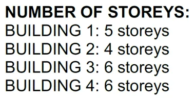
The rezoning application proposes a development consisting of 260 apartment units at a density of 1.6 FSR in four buildings. The applicant has expressed a desire to have a mix of market rental and strata (owned) units, but has not provided further information relating to a percentage mix in that regard.
The applicant has proposed a unit mix of 81 one bedroom units, 163 two bedroom units, and 16 three bedroom units.
In support of the application the following has been submitted:
- Building Plans and Elevations – de Hoog & Kiefulf architects - undated
- Limited Hazardous Materials Investigation – Island EHS – March 20, 2018
- Microtremor Survey Memo – Ryzuk Geotechnical – March 9, 2018
- Parking Study – Watt Consulting Group – September 14, 2018
- Traffic Impact Assessment – Watt Consulting Group – September 13, 2018
- Phase 1 Environmental Site Assessment (ESA) – McElhanney Consulting Services Ltd – March 8, 2018
- Arborist Report: Demolition Impact Assessment and Tree Preservation Plan – Talbot Mackenzie & Associates - September 14, 2018
- Project Sustainability Checklist – applicant – undated
- Applicant’s Statement - de Hoog & Kiefulf architects – September 18, 2018
- DP Area Guideline Compliance Statement - de Hoog & Kiefulf architects – September 18, 2018
The Rezoning Process
An application to rezone a property evaluates the appropriateness of the proposed use and density of the site in the context of on and off-site issues. In considering approval, Council weighs the balance of potential drawbacks with potential benefits of the development for View Royal.
This rezoning proposal is not finalized. This report provides a summary of the existing proposal, and identifies where further work is required. After the Committee of the Whole meeting, staff will work with the applicant to finalize the bylaws and other items required before the application comes forward again to Council, and in advance of any bylaw readings and a Public Hearing.
The application (should it be successful) results in an amendment to the Zoning Bylaw, accomplishing two main things:
- The creation of a new zone; and
- The rezoning of the property to that zone.
A Comprehensive Development (CD) Zone is recommended by staff for two reasons:
- There is no existing zone which addresses the specific height, use and density described in the application.
- A CD zone affords Council the greatest amount of control over the zoning and the resulting future development of the site.
While there is a great amount of detail presented in the application, the rezoning process is one step in several which must be undertaken by the applicant to permit the development of the site. There are issues the rezoning can address, and issues that will be considered at Development Permit.
The rezoning process can address:
- Permitted uses
- Permitted densities
- Maximum lot coverage
- Maximum percentage of impermeable surfaces
- Setbacks to property lines
- Height of buildings
- Size, height and setbacks of accessory structures
- Certain conditions of use of the property
The rezoning process cannot address:
- The vehicle or bicycle parking space provision requirements
- The mechanism by which grade or height of buildings are calculated
- The Development Permit guideline requirements, including architectural styles
- Any regulation contained within the General Regulations in Zoning Bylaw No. 900, 2014
Should the proposal advance to Development Permit stage there may be changes to the proposal and the Development Permit applications may contain variances to the zoning regulations within the Zoning Bylaw. This is typical of an application of this size, and is not due to a failure to recognise or adhere to these regulations during the rezoning process. Rather, variances and other changes to the application will address more detailed issues on-site which were not able to be considered at the time of rezoning.
Proposed Uses
The proposed principal uses for the site are apartment residential units. There is no zone table yet drafted, as the detailed regulations have not yet been finalized.
Proposed Density
The density on the site is expressed in terms of Floor Space Ratio (FSR). Floor Space Ratio is the ratio between the area of the site and the area of the finished floor space on the property. The concept is illustrated below.
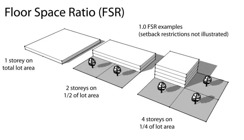
The Mixed Residential land use designation within the Official Community Plan prescribes up to 1.25 FSR for townhouse use and up to 1.6 FSR for apartment use. The proposed FSR for the site is 1.6.
Setbacks from Lot Lines
The lot setbacks are proposed at 4m for Burnside Rd W, 7.5m for Helmcken Rd, 7m on the lot line adjacent to the townhouses to the west, and 8m to the Saanich border to agricultural/rural to the north.
The applicant has indicated 4m at Burnside Rd. W for flexibility, noting that the setback has been drawn at 7.5m on the existing site drawings.
Along the Helmcken and Burnside frontages patios with planters have been indicated. While the architect has stated that the Burnside patios and planters are at grade (and therefore exempt from setback requirements) the same might not be said at the Helmcken interface. It is possible that variances would be required for structures in that location.
Significant consideration will have to be taken regarding setbacks and screening to adjacent residential and to adjacent agricultural.
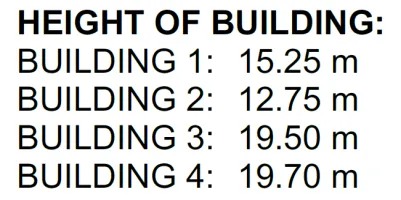
Building Height
The height of a building is calculated from the average grade across a building footprint. The calculation of grade is defined within the Zoning Bylaw and is based on the lower of natural or finished grade at each significant point on a building. The applicant has provided cross-sections of the buildings as part of the application and illustrated below, noting the building numbers in red:
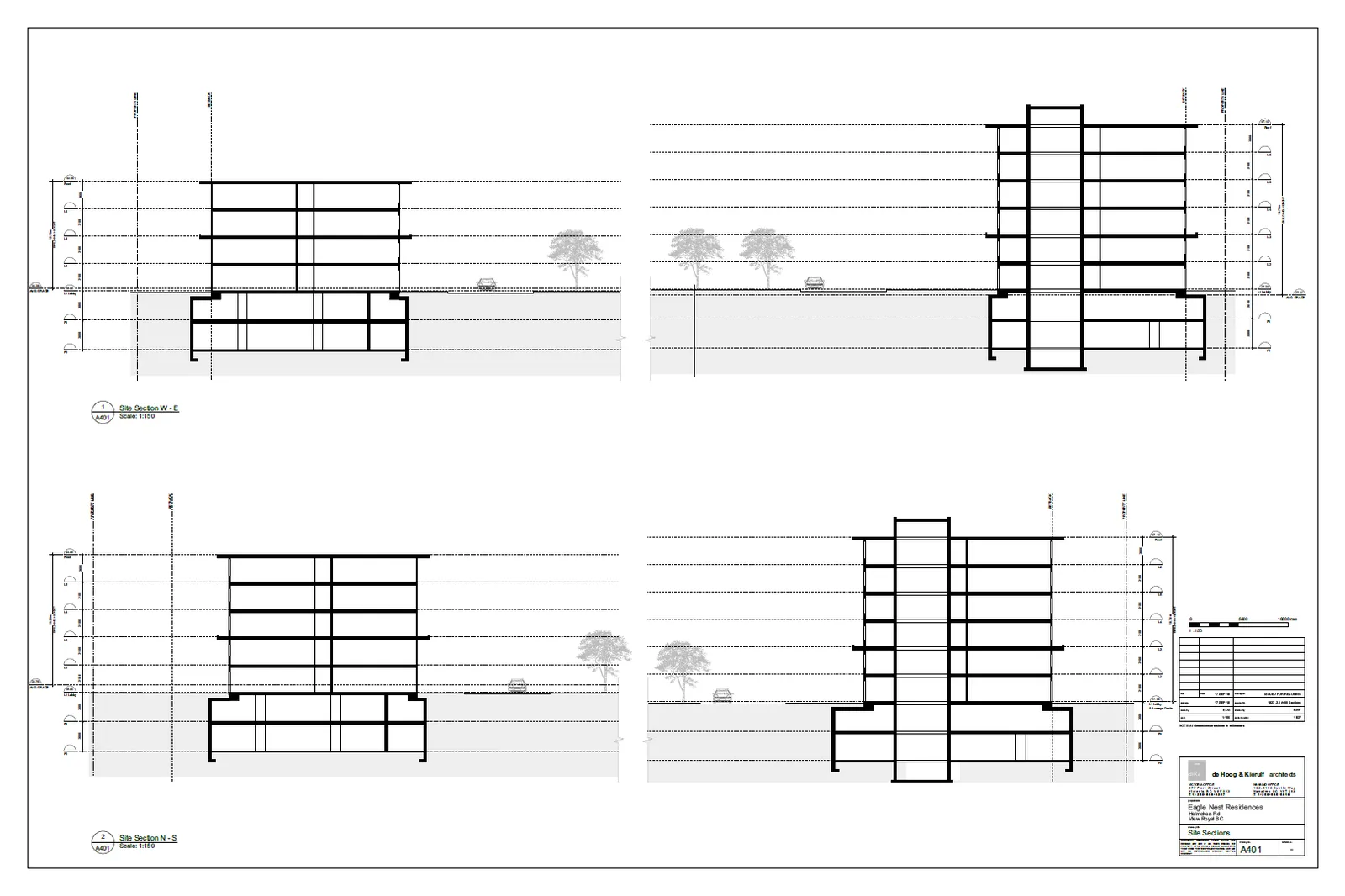
A potential (but not certain) variance at time of Development Permit is to the height of the buildings described within the zone. While the applicant and staff will work together to ensure that the heights proposed in the zone will be the heights at the time of Development Permit, changes in finished grade or changes in building design can impact the final requested heights.
Staff has requested of the applicant a shading study to determine the impacts of the buildings on adjacent properties.
Visual Impact
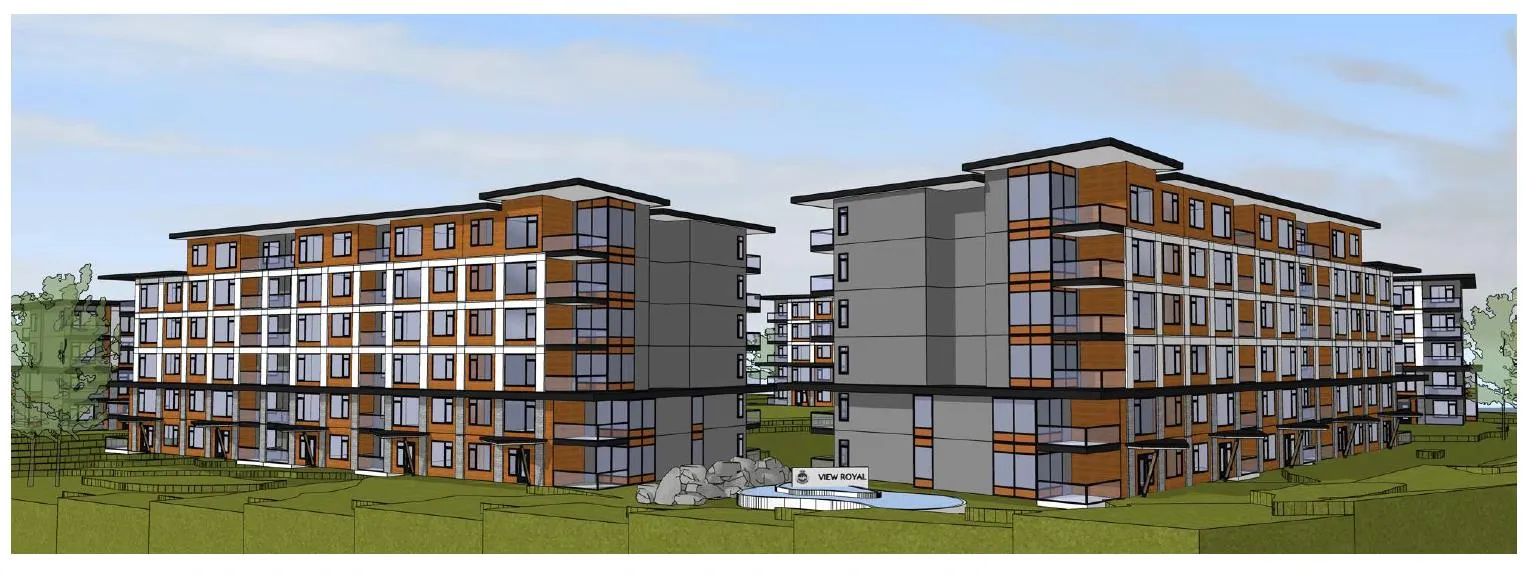
A side-effect of building height is visual impact. The corner of Burnside and Helmcken is considered a gateway entrance to View Royal. OCP Policy LU11.1 speaks to creating a quality built environment to serve the northern gateway to the town, and creating a strong sense of place in that area. The scale of the six storey development there will provide an entrance feature to View Royal, and it must be carefully considered both at time of rezoning, and at time of Form and Character Development Permit.
The applicant has provided renderings to show how the development may appear from several vantage points:
Below shows a perspective elevation at the corner of Burnside and Helmcken:
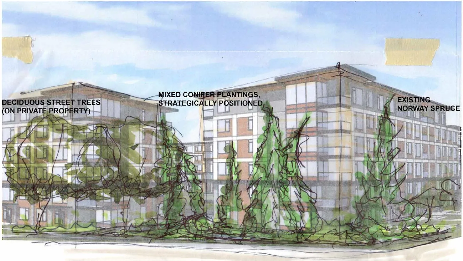
The applicant has also provided an artist’s rendering with a softening of the elevation with windows along the entire façade and mature trees in the foreground:
This view shows the elevation along Burnside Rd. W, including the access driveway.
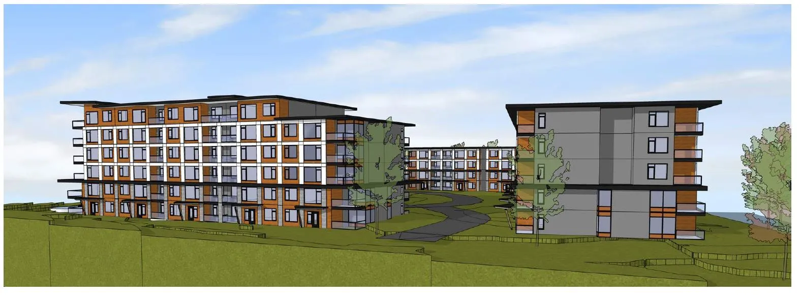
Currently the proposed renderings are unremarkable in terms of creating a sense of place and a gateway feel to the community. This issue is one that will be resolved at time of Development Permit.
Visual impacts of the development could change in the future depending on several factors which can be determined at the Development Permit stage, including height and architectural style of the building, and tree planting or removal.
Proposed Zoning
Based on the current proposal, this is what the zone table could look like:
| Lot Size | |
|---|---|
| Lot size, minimum | 13,800m² |
| Lot Density | |
| Floor Space Ratio, Base Density | 1.6 |
| Lot Coverage, maximum | 34% |
| Impermeable Surface Coverage, maximum | 60% |
| Building Size | |
| Building Height, Maximum | 19.7m |
| Building Width, Minimum | 6m |
| Accessory Building Height, maximum | 4.5m |
| Siting of Principal Buildings and Other Structures | |
| Front Lot Line Setback, minimum (Burnside) | 4m |
| Rear Lot Line Setback, minimum (Townhouses) | 7.5m |
| Side Lot Line Setback, minimum (Saanich land) | 8m |
| Flanking Lot Line Setback, minimum (Helmcken) | 7.5m |
| Siting of Accessory Buildings and Other Structures | |
| Siting of accessory buildings and structures | 7.5m |
Parking Requirements
Off-street parking requirements are determined in the General Regulations of the Zoning Bylaw; this includes parking for vehicles and for bicycles. Parking space provision requirements cannot be amended by the rezoning process, but the provision of parking can impact the development potential on the property. It can have negative impacts on surrounding properties if insufficient parking is provided. The required provision of parking may be reduced with a variance.
The Zoning Bylaw requires the following parking space provisions:
| Unit Type | Off-street vehicle parking requirement per unit | Class 1 Bicycle Parking requirement | Class 2 Bicycle Parking Requirement (per bldg) |
|---|---|---|---|
| 0-1 bedroom unit | 1 | 1 | One 6-space rack |
| 2 bedroom unit | 1.5 | 1 | One 6-space rack |
| 3+ bedroom unit | 2 | 1 | One 6-space rack |
There are two types of bicycle parking spaces, defined within Section 5.11.2 of the Zoning Bylaw:
“Class 1” bicycle parking means a secure, weather-protected bicycle parking facility used to accommodate long-term parking, such as for residents or employees, usually within a building or covered, fenced area;
“Class 2” means a short-term visitor bicycle parking facility that may offer some security, and may be partially protected from the weather, for example a bike rack at a building’s entrance.
Vehicle Parking Requirements
There are two types of vehicle parking spaces described within the Zoning Bylaw:
- Standard parking space: 2.6m in width, 5.5m in length
- Small car parking space: 2.4m in width, 4.8m in length
Up to 30% of the required parking spaces can be supplied as small car spaces. Additionally, up to 15% of required vehicle parking spaces can be supplied as a $12,000 cash-in-lieu contribution to the provision of alternative transportation initiatives within the Town of View Royal. The 15% parking provision does not require Council or staff approval; it is an option available to an applicant as-of-right.
The zoning bylaw requires that multi-family developments with more than 100 parking spaces provide an electric vehicle charging station on the site.
Proposed Vehicle Parking Provisions
The applicant has provided a parking study as part of the proposal. The applicant is proposing 260 residential units. The applicant has not yet provided any visitor-specific parking spaces expressly indicated. It is typical of a project this size to provide visitor-specific parking, even as there is no distinction made between visitor parking and assigned parking within the Zoning Bylaw.
The total provision of parking is currently proposed at 366, whereas 358 are required. This results in a parking provision ratio of 1.41. The included parking study recommends a provision of 273 parking spaces at a parking ratio of 1.05. The study also shows a demand estimate of 20 visitor parking spaces. Staff will be liaising with the applicant regarding a more detailed parking provision in the drawings.
Currently all parking spaces are indicated as underground in two levels, even as there appears to be dedicated space at-grade around the loop driveway. Staff will seek clarification.
Proposed Bicycle Parking Provision
One Class 1 space is required per unit; 260 are required and 260 are proposed. It is unclear at this point where the at-grade 6-space parking is provided but staff suggests one 6-space stall per building.
Staff will request information relating to the provision of oversized cargo/utility bike parking, which would be provided at the Form and Character Development Permit stage. It is proposed that a bicycle maintenance station be included on-site; staff suggests that one should be required per building.
Protective Services
Fire has indicated that they have no objection to the proposal.
Arborists’ Report and Tree Retention
The applicant has submitted an arborists’ report by Talbot Mackenzie and Associates outlining tree conditions and retention potential.
The summary indicates that there are 105 trees on site, and that the majority of trees on the site will be removed as a requirement of the development, though there may be an opportunity to retain some trees on the perimeter of the property.
The report makes a series of recommendations, and at the Environmental Development Permit stage staff will work closely with the applicant and their consultants to ensure that the recommendations are incorporated into the detailed site design and included as conditions of the permit. Tree protection measures are a required component of the Building Permit process and the report makes recommendations for the mitigation of damage to trees and roots during the demolition and construction phases of the project.
Transportation Impact
Transportation impact is a significant determinant of the feasibility of a rezoning. The applicant has submitted a transportation impact assessment by Watt Consulting Group. Staff received the report on November 6, 2018 and has not yet had a chance to review it. If the application moves forward, a robust Transportation Impact Assessment consistent with terms of reference provided by the Town will be required.
Archaeology
Archaeology is regulated by the province through the Heritage Act, and as such the Town is not directly involved with issues related to it. The Town referred a copy of the file to the Archaeology Branch at the Provincial Government; the site shows three areas of potential but the referral indicated that there was no need for investigation. Standard procedures on site should be followed if artifacts are encountered in the process of demolition, excavation and development.
Servicing Capacity
Town of View Royal Engineering has provided preliminary comment in conjunction and consultation with the District of Saanich’s Engineering Department, and are attached to this report. CRD water services has also provided comment (attached).
Community Amenity Contributions (CACs)
CACs are negotiated amenity contributions agreed to by the applicant/developer and local government as part of a rezoning process initiated by the applicant/developer. CACs can take several forms including the provision of amenities, affordable housing and/or financial contributions towards amenities. The agreed-to CAC is obtained by the local government, if the local government decides to adopt the rezoning.
The applicant has not yet contemplated a Community Amenity Contribution.
Staff is recommending that a land lift analysis be undertaken to determine the projected value of the land after it has been rezoned. This valuation will assist staff and Council in determining what an appropriate amenity contribution level would be.
Staff is recommending that a housing agreement be established to secure the following:
- Permanent rental status of the units.
- Details relating to the current offers of assistance for existing residents.
Due to new provincial legislation there is also now the option to zone for rental rather than rely on a covenant for that purpose. Staff will explore the option based on the applicant’s desired mix of rental.
Timing of the amenity contributions will be determined in advance of the application returning for bylaw readings. Any negotiated amenity contribution will be secured through a covenant registered against the title of the property.
Public Consultation
Staff has requested that the applicant summarize their public consultation activities and strategies. Attention should be paid to adjacent land users.
Other Items Required
After a successful rezoning, additional items will be required to enable development. These will include (but are not limited to):
- A Form and Character Development Permits to address Mixed Residential Development Permit guidelines within the Town’s Official Community Plan
- A Servicing Agreement/Site Development Agreement
- Building Permits
- Soil deposit/removal permit (if required)
- Tree removal permits
ANALYSIS AND DISCUSSION
In considering the suitability of the site for the proposed rezoning, Council must weigh the potential drawbacks of the proposal against the benefits it may provide.
The Town’s Official Community Plan contains policies which articulate the Town’s goals objectives and can be used to analyze the proposal at Christie Point from several perspectives.
Hospital Neighbourhood Policies within the OCP
Policy LU11.1 Northern Gateway Community Corridor Support developing the Northern Gateway Community Corridor mixed-use area along Helmcken Road south of Burnside Road.
The Community Corridor will be predominantly mixed residential with ancillary commercial permitted near, and south of, Watkiss Way. New development will be focused on lots fronting Helmcken Road and select lots located off of Watkiss Way. Infill development on adjacent lots in the established residential area will be considered on a case-by-case basis.
Development in the Northern Gateway Community Corridor should be carefully reviewed to consider the following:
- Uses and densities that benefit from the Corridor’s proximity to the Victoria General Hospital and the planned regional rapid transit stop. Attached housing, including townhomes and apartments, should be encouraged throughout the Corridor. Ground level commercial uses should be encouraged on the large parcel at the northwest corner of Helmcken Road and Watkiss Way and the southeast corner of Helmcken Road and Chancellor Avenue. Acceptable commercial uses include medical offices and related facilities, small format retail, restaurants, food stores and accommodations. Unacceptable uses include big box retail and wholesale outlets.
- Access and circulation.
- Quality of the built environment.
- Wayfinding and placemaking elements that reinforce the Hospital Neighbourhood as the northern gateway to View Royal, and create a strong sense of place in the area surrounding the hospital and leading into the southern areas of the Town.
- Connections to the planned hospital rapid transit stop, Galloping Goose Regional Trail, Trans-Canada Highway and established residential area east of Helmcken Road.
Discussion of Issues
Housing
The housing discussion for the site can be broken into two significant parts:
- The displacement or temporary disruption of existing residents from 13 occupied market rental units coming to the end of their serviceable lifespan
- The creation of 260 new housing units
As the aging buildings on the site require replacement, the issue of displacement or temporary disruption of residents is unquestionably unfortunate; some residents have lived there for decades and within a rental market with a vacancy rate of less than 1% it is a significant burden for many to find suitable replacement housing. Equally, however, redevelopment of the site is both inevitable and necessary. Given that the existing units are rented at market rates and are not subsidized or non-market housing, and that the Town of View Royal has no specific requirement for the provision of affordable housing in new residential developments, the consideration of what is suitable compensation for existing residents is weighed subjectively and reasonably.
Staff is proposing a land lift analysis to determine the precise value of the property after rezoning. The results will give staff and Council a better understanding of an appropriate level of amenity contributions.
Transportation
Transportation issues are a significant technical determinant of the proposal’s ultimate feasibility. The area experiences significant traffic volumes at peak times of the day. Compounding the issues are the shared ownership of Burnside Road and the intersection at Burnside Road and Helmcken Road with the District of Saanich. It is likely that the volume of traffic generated by the development will result in a significant alteration of the road profile of not only Burnside Road but also the intersection.
Staff is reviewing the Transportation Impact Assessment provided with the application, and the assumptions made therein, including those of walkability, traffic generation, parking requirements, and so forth. A focus for Town staff, in advance of the application coming forward for bylaw readings, will be a clear determination of both traffic supply issues and traffic demand management through alternative transportation initiatives.
There are regional traffic issues associated with this area of the Town. Council must determine whether regional traffic volumes, a lack of a current regional transit solution, the Mackenzie Interchange project and other issues should factor into the ability of the Town to realize its Official Community Plan goals. Both the Official Community Plan and the Transportation Master Plan prioritize multi modal solutions that value pedestrian safety, commuter cycling and transit alternatives to vehicular demand. Regional traffic is highly variable and unpredictable; what is unreasonable today might not be so in the future. More detailed analysis of on and off site issues needs to be considered as part of the rezoning application. Staff anticipates that further on-site issues and recommendations will be made at the Development Permit stage with respect to parking.
Adjacent Uses
The adjacent ALR and townhouse properties are of significant concern when considering a development which maximizes the recommendations made for use and density in the Official Community Plan. Staff has circulated the application to the Agricultural Land Commission for comment on the ALR land to the north in Saanich.
Staff will want to see evidence of consultation with neighbouring users; the townhouses to the west are particularly potentially impacted by new adjacent buildings of these heights.
Conclusion
While the issues of housing and transportation are both significant and needing to be more thoroughly examined in advance of bylaw readings, the proposal meets many of the Town’s ultimate Official Community Plan goals for the site. The proposal represents a net benefit for the Town, given the provision of one, two and three bedroom units. Staff believes that the application is supportable on the basis of land use and density, however additional details with respect to amenity contributions, housing agreement details and technical transportation issues are still needed to understand both on and off site implications of the proposal.
The rezoning application for the site represents the first step in redeveloping this property in line with the Official Community Plan. The rezoning addresses the fundamental issues of use and density. If the application is ultimately approved, future Development Permit will address the details of form and character, building materials, fenestration, lighting, landscaping and detailed tree protection measures.
Next Steps
Staff will work with the applicant to resolve issues as identified in the report and through feedback gained during the Committee of the Whole meeting on November 13, 2018. Currently the major outstanding issues include:
- A complete review of the Transportation Impact Assessment and associated transportation and parking issues.
- Site servicing review.
- Discussion of massing for the appropriateness of the Northern Gateway neighbourhood entrance.
- Better understand project tenures, phasing, resident displacement and affordable housing issues specific to the site.
- Procuring a land lift analysis to determine an appropriate community amenity contribution package.
- Determination of appropriate areas and terms for natural areas covenants and statutory rights-of-way for public access over the site.
- Drafting of a final zone and zone table.
It is too early in the process to discuss potential next Council meetings.
Options/Questions for Council Moving Forward
After considering the introduction to this application, Council has options to consider:
- Move forward with bylaw readings as a goal in early 2019 with the general direction that the application is taking now in terms of the proposed use, height and density.
- Provide feedback regarding desired changes to any of the use, height or density of the project – potential changes to building configuration or general site planning included.
- Indicate that there are insurmountable challenges for the existing proposal and that Council envisions a significantly different direction for the site.
- If options 1 or 2 are considered by Council, direction with respect to a land lift analysis and community amenity contributions is needed.
RECOMMENDATION
THAT Committee receive the report from the Planner entitled ``REZONING INTRODUCTION – 1449 Burnside Rd (Eagle’s Nest)” dated November 7, 2018 for information.
SUBMITTED BY: J. Davison, MCIP, Planning Technician
REVIEWED BY: L. Chase, MCIP, Director of Development Services
ATTACHMENTS:
- Subject Property Map
- Subject Property Orthophoto
- Applicant’s Statement - de Hoog & Kiefulf architects – September 18, 2018
- Building Plans and Elevations – de Hoog & Kiefulf architects - undated
- Limited Hazardous Materials Investigation – Island EHS – March 20, 2018
- Microtremor Survey Memo – Ryzuk Geotechnical – March 9, 2018
- Parking Study – Watt Consulting Group – September 14, 2018
- Traffic Impact Assessment – Watt Consulting Group – September 13, 2018
- Phase 1 Environmental Site Assessment (ESA) – McElhanney Consulting Services Ltd – March 8, 2018
- Arborist Report: Demolition Impact Assessment and Tree Preservation Plan – Talbot Mackenzie & Associates - September 14, 2018
- Project Sustainability Checklist – applicant – undated
- DP Area Guideline Compliance Statement - de Hoog & Kiefulf architects – September 18, 2018
- Internal Engineering comments provided to the developer
- Internal Development Services comments provided to the developer