Planning & Development Report - OFFICIAL COMMUNITY PLAN AMENDMENT APPLICATION 2018/01 AND REZONING APPLICATION 2018/01 – 231 HEDDLE AVENUE
Report introducing an application to rezone 231 Heddle Avenue from detached residential to attached residential for a nine-unit townhouse development.
Planning & Development Report
TO: Committee of the Whole DATE: March 8, 2018 FROM: J. Chow, Senior Planner MEETING: March 13, 2018 FILE NO.: 3440-20-2018/01, 3360-20-2018/01
OFFICIAL COMMUNITY PLAN AMENDMENT APPLICATION 2018/01 AND REZONING APPLICATION 2018/01 – 231 HEDDLE AVENUE
RECOMMENDATION:
That the March 8, 2018 report from the Senior Planner titled “Official Community Plan Amendment Application 2018/01 and Rezoning Application 2018/01 - 231 Heddle Avenue” be received;
AND THAT early and ongoing consultation of the Official Community Plan amendment be waived given the minor nature of the proposal;
AND FURTHER THAT notification to BC Hydro, BC Ministry of Transportation and Infrastructure, BC Transit, Canada Post, Capital Regional District, Esquimalt First Nation, FortisBC, School District No.61, Shaw Cable, Songhees First Nation, and Telus be made of the public hearing for the proposed Official Community Plan amendment bylaw.
CHIEF ADMINISTRATIVE OFFICER’S COMMENTS: I concur with the recommendation.
DIRECTOR OF DEVELOPMENT SERVICES’ COMMENTS: I concur with the recommendation.
PURPOSE: To introduce applications for an OCP amendment and rezoning to permit multi family residential use. The development concept is for nine townhouse units.
BACKGROUND: The 0.45 ha property is at the end of a street in single family residential neighbourhood. The site is rocky and a house proposed for removal is located at the high point of the property. Adjacent to the site are the following as shown in Figure 1:
- To the northeast, four detached residential lots that at one time were part of the subject property.
- To southeast and across the street to the southwest are detached residential lots.
- To the northwest is the former BC Hydro linear property that it now owned by the Town, the Public Safety Building, and Heddle Park which provides a pedestrian connection to Island Highway.
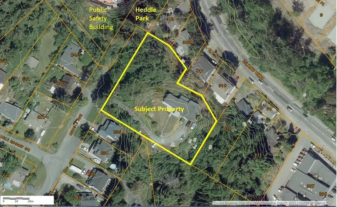
Figure 1. Air Photo
PROPOSAL: The proposal is to:
- Change the Official Community Plan land use designation from Large Lot Residential to Mixed Residential;
- Include the subject property within the Mixed Residential Development Permit Area; and
- Rezone the property from R-1: Detached Residential (Large Lot) to RT-1 (Attached Residential) permit multifamily use.
The applicant’s development concept is for nine units of attached housing in three buildings as shown in Attachments 3-6. This rezoning application would address the issues of land use, density, and standards for lot coverage, percentage of impervious surface, the height and siting of buildings. If the applications are approved, a development permit application would be required to consider the form and character of the development.
The applicant advises that following notification delivered to properties within 100m radius, a neighbourhood meeting was held November 20, 2017 where comments included concerns regarding traffic and blasting.
DISCUSSION: Key issues include the following:
- Policy considerations
- Potential land use impacts
- Community Amenity Contribution
- Potential budget implications
- Next steps for Council consideration of the proposal
1. Policy Considerations Considerations in regard to the proposal include the proposed land use, development permit area designation, and Official Community Plan consultation.
a. Land Use Official Community Plan Bylaw No. 811, 2011 designates the site as Large Lot Residential, which supports predominantly detached homes on large lots. The proposal is to change the land designation to Mixed Residential, which would permit small lot detached houses, townhouses and low rise apartments. This is the same land use designation of all the adjoining lots to the northeast and south east of the subject property.
Rezoning to RT-1 would allow townhouses to provide a transitional buffer between the detached residential neighbourhood to the west and future higher density expected on Island Highway. The proposal would be consistent with relevant Official Community Plan policies that include the following:
Harbour-Helmcken Community Corridor The Harbour-Helmcken Community Corridor is located along the Island Highway between the Helmcken and Harbour neighbourhoods. This section of the Island Highway has historically supported small-format commercial uses combined with a mix of housing. New housing and limited mixed-use development will be encouraged to concentrate around the intersection of Island Highway and Helmcken Road and will be restricted to lots fronting the Island Highway. The area around the intersection is envisioned to be a small, walkable activity hub with supporting residential land uses extending east and west. The character and scale of the Harbour-Helmcken Community Corridor will need to respond to shallow lot sizes, limited parking and the valued character of adjacent residential areas. This Plan envisages the remainder of the properties outside the Helmcken/Island Highway intersection as a mix of residential types, including townhouses and low-rise apartments.
Policy LU1.4 Diversity of Forms and Uses Support a variety of residential and commercial forms and uses to encourage socio-economic diversity, and provide for the diverse needs of youth, families and an aging population.
Policy LU5.4 Urban Growth Boundary Maintain the Urban Growth Boundary (UGB) and continue to direct new urban development and improvements within the boundary.
OBJECTIVE LU9 Preserve the residential scale and character of the Harbour Neighbourhood while accommodating new housing options, shops and amenities closer to where people live.
Policy LU9.1 Harbour-Helmcken Community Corridor Support the development of the Harbour-Helmcken Community Corridor along the portion of the Island Highway located between Burnett Road and Beaumount Avenue.
The Community Corridor area includes lots fronting the Island Highway and some adjoining lots on the north side of the Island Highway. Limited mixed-use intensification and public space improvement should be concentrated at the Helmcken Intersection, with residential uses occupying the other portions of the corridor.
Development in the Harbour-Helmcken Community Corridor should be carefully reviewed to consider the following:
- Mixed-use intensities appropriate for the corridor’s lots sizes and adjacent residential areas. Commercial uses should be neighbourhood-serving and limited to properties located near the Helmcken Intersection.
- Circulation, access and parking.
- Right-of-way conditions and pedestrian safety, including connections across the
- Island Highway and Helmcken Road.
- Placemaking and the quality of the built environment.
- Strong and safe connections to surrounding residential areas, the waterfront, Helmcken Road, View Royal Elementary School and the planned Town Centre.
- Opportunities to consolidate and rezone lots fronting the Island Highway to higher residential densities.
The Harbour-Helmcken Community Corridor should be planned to compliment and not compete with the future Town Centre. Planning decisions in the Harbour and Helmcken neighbourhoods should recognize the community’s aspiration for the development of the Town Centre and ensure that land use planning in other areas does not inhibit eventual development of the Fort Victoria site. Development outside the Community Corridor shall be discouraged.
Policy HS1.1 Range of Housing Types Ensure the policies of this Plan and the regulations of the Zoning Bylaw support a range of housing, including detached homes, small lot subdivisions, apartments, townhouses, secondary suites and other typologies that meet the housing needs of current and future residents.
While Policy LU9.1 states development outside the Community Corridor should be discouraged, the site is large and the proposal may have merit in the overall context of Objective LU9 and the other policies. In this regard, the development concept could preserve the residential scale and character of the Harbour Neighbourhood while providing new ground-oriented housing options.
b. Development Permit Area designation In order to regulate the form and character of the multifamily development proposal, the property should be included in the Mixed Residential Development Permit Area. The adjoining properties to northeast and southeast are also within this development permit area.
c. Official Community Plan Amendment consultation It is recommended that early and ongoing consultation of the Official Community Plan amendment with external agency stakeholders be waived as permitted by the Local Government Act because the proposal to amend the land use designation and incorporate the property into a form and character development permit area does not have significant regional impacts. Informal referrals were sent, with no major concerns noted. Notice of the public hearing for the bylaw is recommended, however.
2. Potential Land Use Impacts
a. Traffic and Servicing The property is at the end of a road and does not have direct vehicle access to Island Highway, but local traffic volumes within the neighbourhood are low. Conclusions and recommendations from the high level traffic review (Attachment 7) regarding the proposed land use can be summarized as follows:
- The addition of the development adds less than 5 vehicles per hour to Heddle Avenue.
- The addition of this traffic has no impact on the surrounding road networks function or operation.
- Heddle Avenue, north of 239 Heddle Avenue should be widened to 6.0m to accommodate the development and emergency services as well as a better aligned road. This widening will impact the hedge, concrete driveway, and paved on-street parking stall on 235 Heddle Avenue. These elements are well within (approximately 8.7m) the public right-of-way for Heddle Avenue.
Staff will be completing review of the Traffic Impact Assessment and servicing concept (Attachment 8) to verify the assumptions and methodology. It should be noted that the availably of on street parking is low in the area and opportunities to on site visitor parking should be investigated further at the development permit stage.
It should be noted that the path in Heddle Park leads directly to a bus stop on Island Highway for Route 14 (Hospital/UVic) which is one of the highest frequency transit routes in the region.
b. Trees There are numerous trees on and around the perimeter of the property, including Douglas Fir and Garry Oak. The arborists report (Attachment 9) notes that trees at the east of the property and on adjacent properties would not be impacted by the proposed development but some careful work will be necessary to retain trees on the municipal boulevard. Tree retention and protection from potential construction impacts will be examined further at the development permit stage.
3. Community Amenity Contribution The principles of Official Community Plan Policy LU1.6 “Community Amenities” encourage the provision of community and neighbourhood amenities associated with new development. There are some local improvements that would provide a community benefit such as provision of a bus shelter on Island Highway to encourage transit ridership or a contribution towards trail improvements on the former BC Hydro linear property. Further discussion with the applicant is recommended, bearing in mind that the scale of the development is not large.
4. Budget Implications There are no significant anticipated budget implications for the Town with regard to the proposal.
5. Next Steps With direction from the Committee of the Whole, staff would work with the applicant to complete the servicing and transportation impact review, discuss the potential for a community amenity contribution, and any other issues that the committee may identify. Once these items have been suitably addressed, staff will report back to the Committee or to Council prior to preparing the bylaws.
RECOMMENDATION:
That the March 8, 2018 report from the Senior Planner titled “Official Community Plan Amendment Application 2018/01 and Rezoning Application 2018/01 - 231 Heddle Avenue” be received;
AND THAT early and ongoing consultation of the Official Community Plan amendment be waived given the minor nature of the proposal;
AND FURTHER THAT notification to BC Hydro, BC Ministry of Transportation and Infrastructure, BC Transit, Canada Post, Capital Regional District, Esquimalt First Nation, FortisBC, School District No.61, Shaw Cable, Songhees First Nation, and Telus be made of the public hearing for the proposed Official Community Plan amendment bylaw.
SUBMITTED BY: Jeff Chow, MCIP, RPP Senior Planner
REVIEWED BY: Lindsay Chase, MCIP, RPP Director of Development Services
ATTACHMENTS
- Location plan
- Letter from Applicant, January 15, 2018 (2 pages)
- A00 Cover sheet – Praxis Architects Inc., January 15, 2018
- A07 Aerial Views - Praxis Architects Inc., January 15, 2018
- A08 Street Views – Praxis Architects Inc., January 15, 2018
- Landscape Plan - Urban Habitats, January 17, 2018
- High Level Traffic Review – Watt Consulting Group, February 14, 2018 (three pages)
- Site Servicing and Storm Water Management Concept Plan – Westbrook Consulting, January 17, 2018 (5 pages)
- Arborists Report, Talbot & McKenzie Nov. 1, 2017 (14 pages)
- Sustainability Checklist (8 pages)
Document Images
(3)