Staff Report - Official Community Plan Amendment Application No. 2018/02 and Rezoning Application No. 2018/02 – 2401 Burnside Road West
A planning report recommending the rezoning of land at 2401 Burnside Road West to permit the construction of a new BC handyDART operation and maintenance facility.
TOWN OF VIEW ROYAL
Planning & Development Report
TO: Committee of the Whole DATE: March 7, 2018 FROM: J. Chow, Senior Planner MEETING: March 13, 2018 FILE NOs: 3440-20-2018/02, 3360-20-2018/02
OFFICIAL COMMUNITY PLAN AMENDMENT APPLICATION 2018/02 AND REZONING APPLICATION 2018/02 – 2401 Burnside Road West
RECOMMENDATION:
That the March 7, 2018 report from the Senior Planner titled “Official Community Plan Amendment Application 2018/02 and Rezoning Application 2018/02 - 2401 Burnside Road West” be received;
AND THAT early and ongoing consultation of the Official Community Plan amendment be waived given the minor nature of the proposal;
AND FURTHER THAT notifications to BC Hydro, BC Ministry of Transportation and Infrastructure, BC Transit, Canada Post, Capital Regional District, Esquimalt First Nation, FortisBC, School District No.61, Shaw Cable, Songhees First Nation, and Telus be made of the public hearing for the proposed Official Community Plan amendment bylaw.
CHIEF ADMINISTRATIVE OFFICER’S COMMENTS:
I concur with the recommendation.
DIRECTOR OF DEVELOPMENT SERVICES’ COMMENTS:
I concur with the recommendation.
PURPOSE:
To introduce applications for an OCP amendment and rezoning to permit a BC handyDART operation and maintenance facility.
BACKGROUND:
1. HandyDART
Launched in 1981, handyDART is a door-to-door custom BC Transit service for registered customers who are unable to use the conventional transit system some or all of the time. It is a shared-ride service that carries multiple customers on the same trip at the same time.
BC Transit indicates that “the existing handyDART facility located on Glanford Avenue is operating beyond capacity, and cannot support the expected need for future growth of the service. The need for a new facility was identified in the Victoria Regional Transit System 2011 Transit Future Plan, which provides a vision for transit over the next 25 years to support the economic, social and environmental sustainability goals of the region. The Transit Future Plan, endorsed by the Transit Commission, was based on local government land use and transportation plans including the Regional Growth Strategy, Travel Choices and Official Community Plans. Existing capacity and anticipated future growth has led to the exploration of new sites for the handyDART facility.”
2. Site
The 3.23 ha parcel is bounded by Trans Canada Highway to the south, Burnside Road West to the west, and Watkiss Way to the north. The east property line generally follows Craigflower Creek. The Galloping Goose Regional Trail runs south from the intersection of Burnside Road West and Watkiss Way before aligning within the former Canadian National Railway right-of-way owned by the Island Corridor Foundation and running eastward. .
The site was extensively disturbed in the past and is now predominantly vegetated with grass and non-native shrubby species with invasive plants such as Scotch broom and Himalayan blackberry. There are wooded areas along the south and east sides of the property where Craigflower Creek runs. There are also two ditches within the site that feed into the creek. An archery range used by Victoria Bowmen Archery Club for several years is situated in a clearing at the centre of the site. BC Transit has indicated that it would commit to assisting the club to seek a new location for 2019 if the development proposal is successful.
Site constraints include the following as shown in Figure 1:
- The property is bisected by the former Canadian National Railway that runs east-west through the site.
- The Galloping Goose Regional Trail runs along the rail corridor before diverging along a statutory right-of-way to the Burnside Road West / Watkiss Way intersection where new traffic signals have recently been installed
- The two major Capital Regional District water mains that serve the core municipalities and the Saanich Peninsula runs along the north edge of the rail corridor.
- A BC Hydro statutory right of way for overhead transmission lines and structures travels from the northwest to the southwest through the parcel
- Craigflower Creek is a fish bearing watercourse subject to Provincial Riparian Areas Regulations and is within the Town’s Natural Watercourse and Shoreline Development Permit Area.
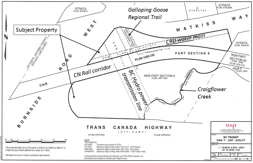
Figure 1. Subject property
PROPOSAL:
- To amend the OCP land use designation from Parks, Open Space, Recreation to Community Facility
- To include the site within a form and character development permit area
- To rezone from P-3 (Parks and Recreation) to a new zone to permit a BC handyDART operation and maintenance facility.
If the rezoning is approved, a development permit application would be required to consider the form and character of the development and potential environmental impacts on Craigflower Creek.
Development Concept
BC Transit proposes to acquire the property from the Province to construct a handyDART operations and maintenance facility that includes following:
- A two storey administration and vehicle maintenance building on the east side of the property
- a wash bay and fuel station on the west side of the property
- fleet and staff parking
The development concept is illustrated in Figure 2 and will be outlined in greater detail in the development permit process. General hours of transit service are 7:00am until 10:00pm most weekdays (until midnight on weekends) and 7:00am until 10:00pm on Sundays. Maintenance and operations activities would begin earlier. The initial fleet size would be approximately 90 vehicles with a project long term capacity in the range of 115 vehicles.
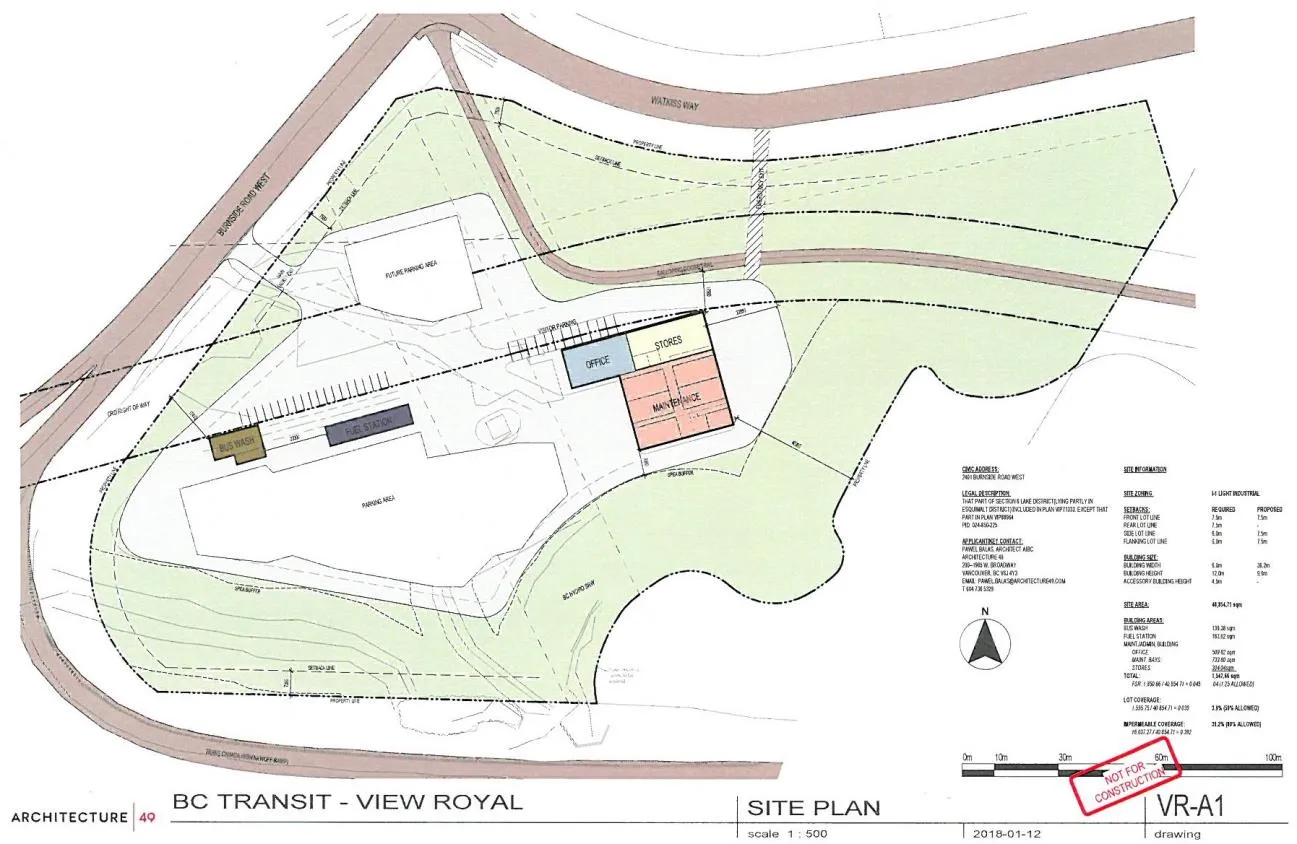
Figure 2. Development Concept
Public consultation
BC Transit advises that notifications were sent in November 2017 to properties within 400 metres supplemented with personal outreach and a media advisory that was also posted on the BC Transit Victoria Region website. A public open house was held on February 20, 2018.
DISCUSSION:
Key issues include the following:
- Policy considerations
- Potential land use impacts
- Community Amenity Contribution
- Proposed zone
- Potential budget implications
- Next steps
1. Policy Considerations
Policy aspects of the proposal include land use and development permit area considerations.
a. Land Use
Official Community Plan Bylaw No. 811, 2011 designates the site as Parks, Open Space, Recreation. Changing the land use designation to Community Facility and rezoning the site would allow BC Transit to construct a new facility and expand a regional transit service that is vital for those people that cannot easily use the conventional transit system. This site has good long term potential for the proposed use because the location is central to the region and has good screening and separation from residential neighbourhoods.
The principle of the proposed land use is supported by two overarching Official Community Plan goals in the community vision statement:
Community Vision 2. Create an inclusive community that provides housing, transportation and healthy living options, and services and facilities for families and individuals of diverse backgrounds, cultures, ages and economic means. 8. Recognize the regional role of the community as a link in major transportation and environmental systems, and cooperate with other municipalities and governments to address regional issues, while also protecting local values and promoting long-term sustainability.
These goals helped establish the framework for the Official Community Plan policies that relate to the proposal, which include the following:
Policy TR1.1 Multimodal Transportation System Support and encourage the development of View Royal’s pedestrian, cycling, public transit networks as part of an interconnected multimodal transportation system.
Policy TR1.4 Transit Services Promote transit use as a viable alternative to car travel. Advocate for increased transit service and options to meet the diverse needs of the community, including youth, working adults, seniors and people with mobility challenges. Continue to work with BC Transit to improve the level of service to View Royal’s neighbourhoods, particularly in the Thetis Vale area.
Policy TR3.1 Transportation Master Plan Support the safe and efficient movement of vehicles, cyclists and pedestrians throughout View Royal in accordance with the priorities and strategies established in the [2008] Transportation Master Plan.
Recommendations in the 2008 Transportation Master Plan include working with BC Transit to improve transit service through View Royal.
ACTION TR5 Liaise with BC Transit to maximize opportunities for transit use, maintain long-term options for improvements, and coordinate effort to ensure transit infrastructure is planned to support the Community Vision and sustainable, local development.
Policy HS1.2 Age in Place Encourage appropriate housing – both market and non-market – for seniors to allow residents to age in place within the View Royal community. This includes promoting the development of accessible and adaptable units that are specifically designed for those with physical constraints and mobility limitations.
ACTION HS4 Encourage the design of Adaptable Housing to increase the future supply of units available for people with physical disabilities or limited mobility, and seniors.
d. Development Permit Area
Part of the site is within the Natural Watercourse and Shoreline Development Permit Area. Staff propose that this site also be included in a form and character development permit area. This may require the creation a new form and character development permit area for industrial development.
It is recommended that early and ongoing consultation of the Official Community Plan amendments be waived as permitted by the Local Government Act because the proposal to amend the land use designation and to incorporate the property within a form and character development permit area does not have significant local or regional impacts.
2. Potential Land Use Impacts
While the policies support improvements to the transit system, potential land use impacts for the proposed location are being assessed by staff. Potential land use impacts include the following:
a. Traffic, Servicing and Parking
A servicing concept plan (Attachment 8) and traffic impact assessment (Attachment 9) have been submitted and are under review and staff will report back on the findings. The traffic impact assessment includes a recommendation for a turning lane on Burnside Road West for vehicles turning into the site. The traffic impact assessment also predates the scheduled March 12, 2018 opening of the new traffic signal at the Burnside Road West / Watkiss Way intersection. The development concept is for all parking to be accommodated on site.
An emergency access is proposed so that vehicles can access Watkiss Way if Burnside Road West is blocked. Staff will provide comment this concept. The applicant proposes flagging for safe crossing of the Galloping Goose Regional Trail, however the long term status of the rail corridor needs to be confirmed.
b. Environment
The facility would occupy the generally cleared areas of the site. Approximately 12 trees would be removed, with 80 new trees proposed to be planted on and off site. A biologists report has been prepared that identifies the Streamside Protection and Enhancement Area (SPEA) for the watercourses on the site. Enclosure of one ditch on the site could reduce the coverage of the SPEA if it can be proven that there would be no impacts downstream in fish bearing waters.
At the development permit stage, more detailed work will be conducted to ensure that there are no adverse impacts on Craigflower Creek. The servicing concept acknowledges that storm water management will have to meet requirements for discharge into a fish bearing watercourse. The vehicle servicing and bus washing stations will have to meet CRD point source control requirements for waste water.
A baseline noise study is being conducted on site. Staff recommends that a noise study be conducted at the existing facilities at Royal Oak Industrial Park. While the settings are very different, it would help to provide an assessment of how sound levels from the current operations compare to highway noise at the subject property.
3. Community Amenity Contribution
Applicants for rezoning applications often include community amenity contributions that can benefit the greater community. The part of the parcel between the rail corridor and Watkiss Way may be surplus to the needs of the facility. There are constraints on this land due to numerous statutory rights-of-way but it may be of interest to the Town as it is and that could have potential as an affordable housing site. Official Community Plan Policy HS1.9 “Innovative Approaches”, supports innovative approaches to creating affordable housing including market rental, cooperatives, co-housing and other forms of shared ownership, mixed market and non-market projects, and public-private partnerships. Further discussion with the applicant is recommended.
4. Proposed Zone
Staff will prepare a new zone that will accommodate the proposed land use. Staff intends to create a zone that allows for a regional transit facility appropriate to the Community Facility land use designation, rather than a service commercial or general industrial zone.
5. Budget Implications
There are no significant anticipated budget implications for the Town. If land is provided as a community amenity contribution, there may be some land management costs.
6. Next Steps
With direction from the Committee of the Whole, staff would work with the applicant to resolve the following items and any other issues that the committee may identify:
a. Site Layout The site plan shows parking and circulation on part of the former Canadian National railway corridor. Special permission is also required from BC Hydro to permit parking under power transmission lines. It should be confirmed as soon as possible if this aspect of the development concept is possible and if not, whether an alternative layout is viable on site.
b. Contaminated Site Regulations The Phase 1 investigation did not reveal signs of major site contamination; however there is evidence of fill deposited on the site. A Phase 2 (detailed) Site Investigation is underway to determine if site remediation is required. Following the site investigation, the applicant will have to work with the Province what measures may be taken to coordinate with the rezoning and development permit process.
c. Community Amenity Contribution The part of the parcel north of the rail corridor may be surplus to the needs of the facility. There are constraints on this land due to numerous statutory rights-of-way but it may be of interest to the Town as a community amenity contribution as it is land that could have potential as an affordable housing site. A community amenity contribution can only be provided or secured at the time of rezoning. Further discussion with the applicant is recommended.
d. Ditch enclosure One of the two onsite ditches is proposed for enclosure. The biologists report indicates there is no evidence that it is fish bearing; however the potential impact of this proposal on the SPEA should be assessed as it might be possible to reduce the size of the SPEA.
e. Technical review Staff will soon be completing review of the servicing concept and transportation impact assessment. It is recommended a noise study be conducted at the current site of operations at Royal Oak Industrial Park for comparison with the baseline study being conducted on the subject property.
Once these items have been suitably addressed, staff will report back to the Committee or to Council, and a rezoning amendment bylaw can then be prepared for Council consideration.
RECOMMENDATION:
That the March 7, 2018 report from the Senior Planner titled “Official Community Plan Amendment Application 2018/02 and Rezoning Application 2018/02 - 2401 Burnside Road West” be received;
AND THAT early and ongoing consultation of the Official Community Plan amendment be waived given the minor nature of the proposal;
AND FURTHER THAT notifications to BC Hydro, BC Ministry of Transportation and Infrastructure, BC Transit, Canada Post, Capital Regional District, Esquimalt First Nation, FortisBC, School District No.61, Shaw Cable, Songhees First Nation, and Telus be made of the public hearing for the proposed Official Community Plan amendment bylaw.
SUBMITTED BY: Jeff Chow, MCIP, RPP Senior Planner
REVIEWED BY: Lindsay Chase, MCIP, RPP Director of Development Services
ATTACHMENTS
- Location plan
- Air Photo – WSP
- Topographic Survey - WSP
- Letter from Susan Brice, Victoria Regional Transit Commission - January 30, 2018
- Letter from Applicant - February 2, 2018 (4 pages)
- Site Plan – WSP, January 12, 2018
- Street Perspectives – WSP, January 12, 2018 (2 pages)
- Preliminary Site Servicing Investigation – WSP, November 8, 2017 (2 pages)
- Transportation Impact Assessment – WSP, Dec. 22, 2017 (22 pages, excludes appendices)
- Sustainability Checklist (8 pages)
Document Images
(3)