Staff Report: DEVELOPMENT PERMIT 2016/05 – 1950 Watkiss Way
Planning evaluation of a development permit application for a mixed-use building near Burnside Watkiss Park.
TOWN OF VIEW ROYAL
Planning & Development Report
TO: Mayor & Council DATE: June 8, 2016 FROM: J. Chow, Senior Planner MEETING DATE: June 14, 2016 FILE NO.: 3060-20-2016/05
DEVELOPMENT PERMIT 2016/05 – 1950 Watkiss Way
RECOMMENDATION:
THAT the June 8, 2016 report from the Senior Planner titled “Development Permit 2016/05 – 1950 Watkiss Way” be received.
CHIEF ADMINISTRATIVE OFFICER'S COMMENTS:
I concur with the recommendation.
DIRECTOR OF DEVELOPMENT SERVICES' COMMENTS:
I concur with the recommendation.
PURPOSE OF REPORT:
To introduce a development permit application for a four storey commercial/residential mixed use building comprised of 305m² of commercial office space on the ground floor and 44 rental apartment units on the upper three floors.
BACKGROUND:
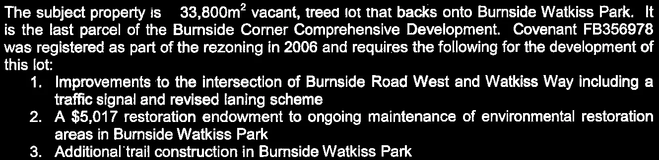
- Improvements to the intersection of Burnside Road West and Watkiss Way including a traffic signal and revised laning scheme
- A $5,017 restoration endowment to ongoing maintenance of environmental restoration areas in Burnside Watkiss Park
- Additional trail construction in Burnside Watkiss Park
- Sharing the driveway on the adjoining lot at 1900 Watkiss Way as the vehicle access
- Frontage improvements along Watkiss Way
- Preparation of an Integrated Pest Management Plan to minimize pesticide use
PROPOSAL:
The building would be in the contemporary West Coast contemporary style. The commercial ground floor would feature natural/cultured stone veneer and extensive glazing as shown in Attachments 11-12. The upper floors would have combination of cementitious and natural or simulated wood siding. The building would be articulated with a series of raised shed roof sections, balcony projections and floor plate variations to provide architectural interest and mitigate the massing of the building.
The development would be accessed by a shared driveway on the adjoining property at 1900 Watkiss Way. Surface and underground parking would be provided. Storm water would be managed through the use of interceptors to clean runoff and control its entry into the municipal storm drain. There are approximately 45 trees on the site. With the extensive blasting and clearing required, three can be retained. This is to be expected, because density was clustered on the three development sites in the Burnside Corner Comprehensive Development so that Burnside Watkiss Park could be preserved as green space.
ANALYSIS:
A. Development Permit Area Guidelines
The site is located in the Neighbourhood Mixed Use and Sensitive Terrestrial Ecosystems Development Permit Areas. It is unusual that this site and the adjoining parcels are in the Sensitive Terrestrial Ecosystems Development Permit Area as density was allocated to these sites to preserve Burnside Watkiss Park as green space; the review of the guidelines is therefore focused on minimizing impacts on the park. The proposal generally complies with the development permit area guidelines and principles; however some additional information is needed as highlighted in Attachment 15 and summarized in Section C of this report.
B. Zoning and Requested Variances
The site is subject to the requirements of the CD10: Comprehensive Development (Burnside Corner) zone and CD-10C: Detached Multiple-Unit Residential subzone. Table 1 summarizes the zoning requirements.
Table 1. Zoning Review
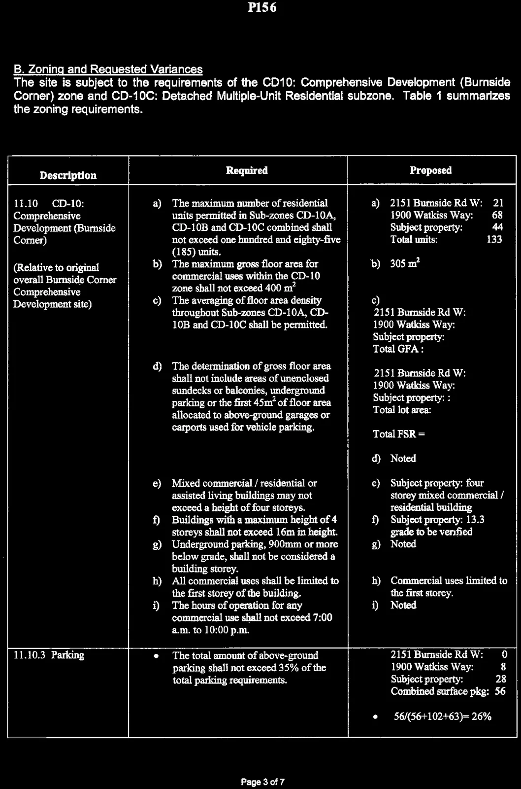
1900 Watkiss Way: 68
Subject property: 44
Total units: 133 | | | b) The maximum gross floor area for commercial uses within the CD-10 zone shall not exceed 400 m² | b) 305 m² | | | c) The averaging of floor area density throughout Sub-zones CD-10A, CD-10B and CD-10C shall be permitted. | c)
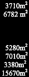
2151 Burnside Rd W: 3710m²
1900 Watkiss Way: 6782 m²
Subject property:
Total GFA: | | | d) The determination of gross floor area shall not include areas of unenclosed sundecks or balconies, underground parking or the first 45m² of floor area allocated to above-ground garages or carports used for vehicle parking. | 2151 Burnside Rd W: 5280m²
1900 Watkiss Way: 7010m²
Subject property: 3380m²
Total lot area: 15670m²
Total FSR =
d) Noted | | | e) Mixed commercial / residential or assisted living buildings may not exceed a height of four storeys. | e) Subject property: four storey mixed commercial / residential building | | | f) Buildings with a maximum height of 4 storeys shall not exceed 16m in height. | f) Subject property: 13.3 m grade to be verified | | | g) Underground parking, 900mm or more below grade, shall not be considered a building storey. | g) Noted | | | h) All commercial uses shall be limited to the first storey of the building. | h) Commercial uses limited to the first storey. | | | i) The hours of operation for any commercial use shall not exceed 7:00 a.m. to 10:00 p.m. | i) Noted | | **11.10.3 Parking** | The total amount of above-ground parking shall not exceed 35% of the total parking requirements. | 2151 Burnside Rd W: 0
1900 Watkiss Way: 8
Subject property: 28
Combined surface pkg: 56
• 56/(56+102+63)= 26% |


• Financial Institution
• Office
• Café
• Health Salon or Health Spa
• Laboratory facility
• Laundromat
• Laundry and Dry Cleaning
• Live/Work Studio
• Medical Clinic
• Full-Service Restaurant
• Residential Apartment
• Retail
• Personal Service Establishment | • Office
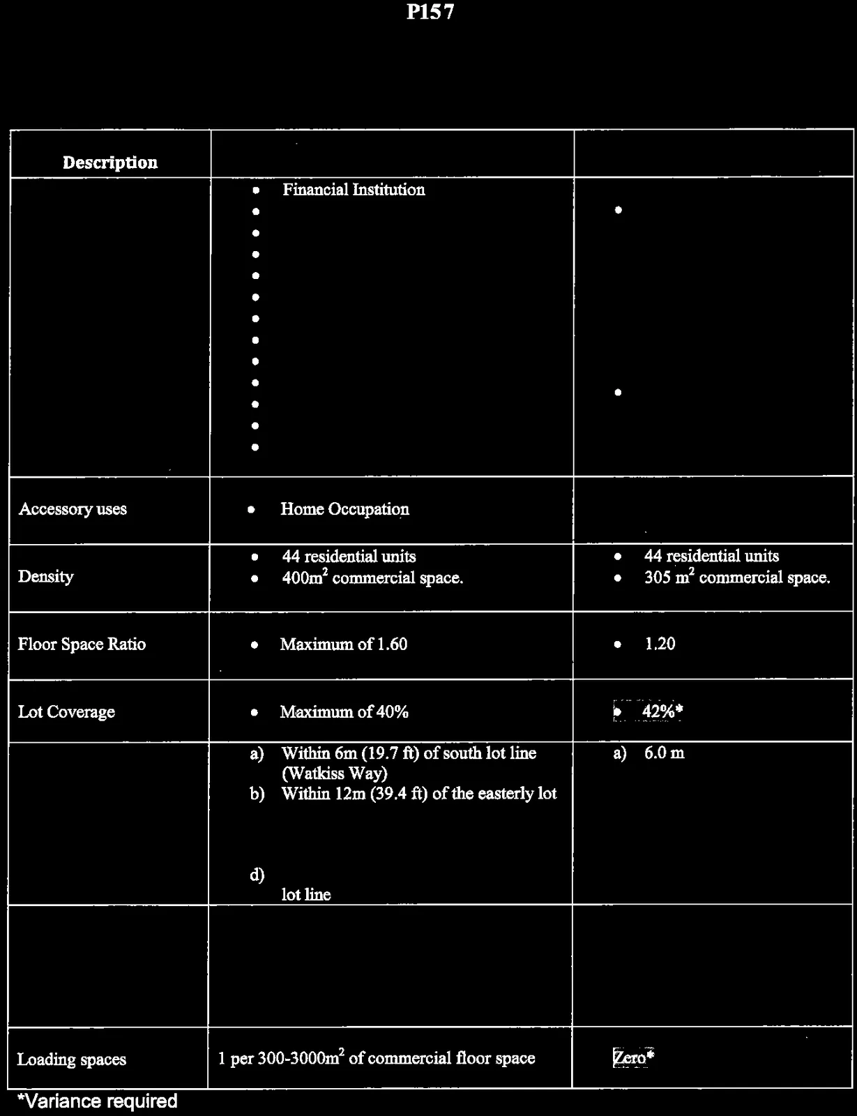
• Residential Apartment | | **Accessory uses** | • Home Occupation | | | **Density** | • 44 residential units
• 400m² commercial space. | • 44 residential units
• 305 m² commercial space. | | **Floor Space Ratio** | • Maximum of 1.60 | • 1.20 | | **Lot Coverage** | • Maximum of 40% | • 42%* | | **Setbacks** | a) Within 6m (19.7 ft) of south lot line (Watkiss Way)
b) Within 12m (39.4 ft) of the easterly lot line
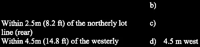
c) Within 2.5m (8.2 ft) of the northerly lot line (rear)
d) Within 4.5m (14.8 ft) of the westerly lot line
b) 12.0 m building
1.2 m* garbage enclosure
c) 2.5 m
d) 4.5 m west | | **Parking** |
1.0 per 1BR unit x 29 = 29.0
1.5 per 2BR unit x 15 = 22.5
1 per 25m² Commercial = 12.2
Total = 64.0 | 61 spaces* | | **Loading spaces** | 1 per 300-3000m² of commercial floor space | Zero* |
*Variance required
Several variances are requested and they are mostly minor. The increased lot coverage can be supported so that the floor plate can support a density that would enable the provision of the specified amenities. The siting of the garbage enclosure can be supported because it is screened by grade and landscaping from the adjoining property.
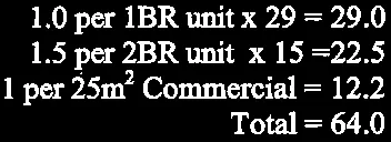
The request to provide 61 parking spaces (64 required) can be supported as it is a rental building where parking can be allocated by the owner however on site visitor parking spaces should also be considered as there is high demand for the limited street parking near Eagle View Elementary School at times. The variance to reduce the number of loading spaces from one to zero can be supported because the office is 305m², which is at the low end of the range where a loading space is required – loading space demand is not expected to be high for this development. The plans also indicate a variance for the percentage of small car spaces may be needed but the figures need to be provided. Requests for more variances may arise once additional information has been provided.
C. Additional Information and Next Steps
For the application to be considered by Council, the following should be provided:
- Response to comments on the proposal that may arise at the Committee of the Whole meeting
- Relevant information that may be requested from the application referral process that will be concluding shortly
- The following additional information:
Development Permit Area Guidelines a. Provide colour and material sample board b. Provide roof plan and description of rooftop mechanical equipment (if any) c. Show description and location of outdoor bicycle racks on site plans d. Show location of meters and transformers on site plans e. Provide exterior lighting (fixture) details on the plans; plans to note that exterior lighting fixtures are to be "dark skies" friendly to limit light pollution at night; where pole-mounted lighting is necessary, light standard luminaries shall be no more than 40,000 lumens and mounted on poles no more than 5 metres high; light fixtures should be consistent with the general design character of the building f. Outdoor electrical outlets should be provided at regular intervals to facilitate the installation of seasonal/decorative outdoor lighting. g. Provide a sign plan showing materials, location, maximum dimensions, and illumination; where used, all signage should be architecturally compatible with the style, composition, materials, colours and details of the buildings, with no internal illumination, and method of installation hidden. h. Provide a tree protection and retention plan with recommendations to mitigate construction impacts on adjacent trees in Burnside Watkiss Park
Zoning i. Show how Grade was calculated j. Show dimensions of surface parking spaces (minimum of 2.6m in width, a minimum of 5.5m in length exclusive of access aisles, overhead clearance of 2.1 m) and access aisles. Parking spaces adjacent to a wall or other encumbrance should be at least 2.9m wide. k. Show gradient and cross slope of all parking space areas (max. 6 % permitted) l. Label and dimension small car parking spaces m. Confirm bike storage dimensions n. Indicate height of all retaining walls
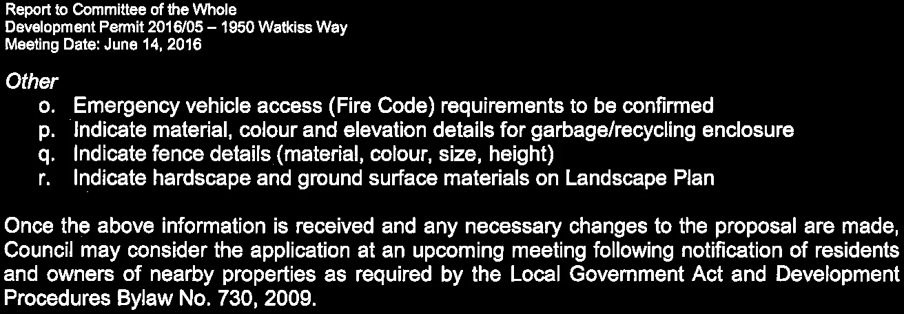
Once the above information is received and any necessary changes to the proposal are made, Council may consider the application at an upcoming meeting following notification of residents and owners of nearby properties as required by the Local Government Act and Development Procedures Bylaw No. 730, 2009.
RECOMMENDATION:
THAT the June 8, 2016 report from the Senior Planner titled “Development Permit 2016/05 – 1950 Watkiss Way” be received.
SUBMITTED BY: J. Chow, MCIP, RPP, Senior Planner REVIEWED BY: L. Chase, MCIP, RPP, Director of Development Services
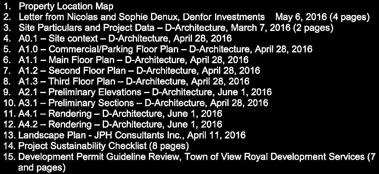
ATTACHMENTS: