ENVIRONMENTAL DEVELOPMENT PERMIT NO. 2022/04 - 53 KNOLLWOOD ROAD
Review of a development permit application for slope stabilization and landscaping involving gabion walls and tree removal.
TOWN OF VIEW ROYAL PLANNING & DEVELOPMENT REPORT
TO: Committee of the Whole
DATE: May 4, 2022
FROM: J. Chow, Senior Planner
MEETING DATE: May 10, 2022
FILE NO.: 3060-20-2022-04
ENVIRONMENTAL DEVELOPMENT PERMIT NO. 2022/04 - 53 KNOLLWOOD ROAD
RECOMMENDATION
THAT the May 4, 2022 report from the Senior Planner titled “Environmental Development Permit No. 2022/04 – 53 Knollwood Road” be received for information.
CHIEF ADMINISTRATIVE OFFICER’S COMMENTS
I concur with the recommendation.
DIRECTOR OF DEVELOPMENT SERVICES’ COMMENTS
I concur with the recommendation.
PURPOSE OF REPORT
To introduce a development permit application to install retaining walls and landscaping to stabilize a slope within the Natural Watercourse and Shoreline Development Permit Area for a residential property on Price Bay. A variance to the height of retaining walls is requested.
BACKGROUND
The subject property is approximately 1993 m² and located on the Price Bay waterfront, part of Esquimalt Harbour as show in in Figure 1. It is zoned R-1B: Detached Residential (Medium Lot) and a detached dwelling constructed in the early 1970s occupies the centre of the property as shown in Figure 1.
Supporting reports for this application indicate that perimeter drains are located on both the eastern and western property lines. The eastern pipe discharges at the top of the slope, while the western drain is piped all the way to the foreshore and discharges onto a rock pile. A sewer lateral conveys sewage down to a sewer main that runs underground along the shore to the Town’s Price Bay pump station.
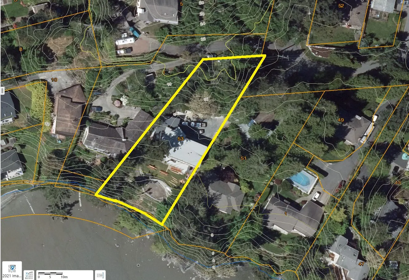
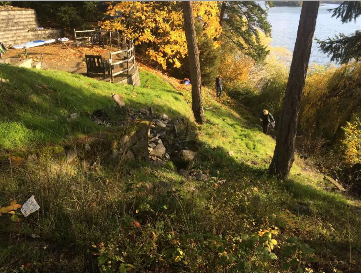
The geotechnical report (Attachment 2) estimates the overall foreshore slope is about 8-10m high from the edge of the upper back yard to the shoreline over a horizontal distance of about 20m. The biologists report (Attachment 3) indicates that “the slope ends in a vertical- to undercut bank of 1-2 m varying height at the shoreline of the exposed intertidal mudflats of Price Bay. Portions of exposed bedrock were observed at the western property shoreline”. The geotechnical report provides a timeline of events on this steep slope is as follows:
| Year | Event |
|---|---|
| 1993-1994 | Three mortared rock walls with fill were installed to terrace the waterfront slope |
| 1995 | Slope failure resulted in the loss of a portion of the back yard and shifting of walls and trees approximately 2m down the slope |
| 1996 | Geotechnical inspection concluded factors for slide included fill deposit, a ruptured sewer lateral and heavy rains (sewer lateral leading to a sewer main along the shore said to have been repaired) |
| 2014 | Geotechnically engineered patio and Allan block retaining wall constructed near crest of slope |
| 2021 | Geotechnical inspection indicates only minor changes have occurred to lower slope since 1996 but creep and erosion is anticipated to continue unless all existing fills can be removed. While Price Bay is a relatively calm environment, the foreshore is also subject to coastal effects such as wave impact at the toe, especially during storm events in conjunction with high tide and anticipated sea level rise. |
Ground cover in the development permit area is primarily comprised of lawn grasses, with the remains of some ornamental and weedy species such as thistles and Himalayan blackberry. Observations from the biologist’s site inspections did not reveal any listed environmentally sensitive ecosystems, red or blue-listed species, or significant environmental features of this type. Non-native vegetation dominates the majority of the DPA, with the exception of the slope edges and shoreline fringe. The shoreline fringe consists of mostly native trees, tall shrub species and understory, except for a large horizontal non-native willow tree. The marine foreshore is a mudflat that is part of the Millstream Creek delta. Attachment 3 provides many site photos.
PROJECT INFORMATION
This development permit application has been submitted to stabilize and replant the slope that is within the Natural Watercourse and Shoreline Development Permit Area. A variance to the height of retaining walls is requested.
The following attachments are provided in support of the application:
- Subject Property Map
- Geotechnical Report – Ryzuk Geotechnical, November 16, 2021 (6 pages)
- Biologist’s report – Fish-KW Environmental, April 12, 2022 (39 pages)
- Tree Impact Assessment, Scotty Tree & Arborist Service, January 7, 2022 (9 pages)
Proposed works
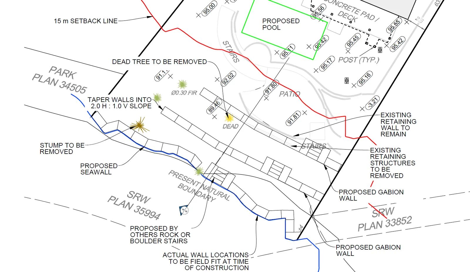
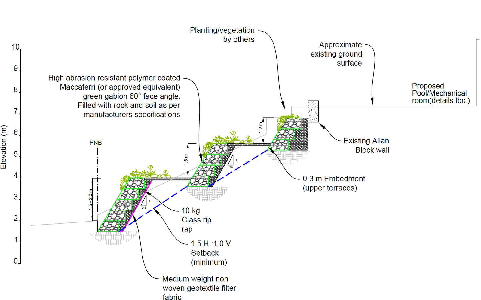
The proposal is to install three levels of gabion walls (mesh cages holding rocks and earth) to stabilize the slope and to keep the existing Allan block retaining wall near the top of the slope. Steps would also be integrated into the gabion walls to provide a route to the shoreline. The gabion walls would be vegetated with appropriate plants. The lowest gabion wall would form a seawall and be planted with saltwater compatible plant species. This gabion would also be a specific type that can be constructed with a 60-degree batter and the wire mesh of the gabion baskets would be galvanized and coated in polymer for corrosion protection from the marine environment.
Trees
The arborists report identifies two mature Douglas firs be removed regardless of whether or not the shoreline stabilization proceeds, as sliding down the slope has cracked the root plates and created a toppling hazard. Tree permits will be required. Nine trees are proposed in the planting plan, including three Pacific crab apple, three Pacific yew, two Pacific dogwoods, and one arbutus. The report contains recommendations to be included in the development permit, including:
- Arborist direction or supervision is required for excavation of the back yard
- Careful excavation is required when digging down past original grade near neighboring
- property lines
- Install anti-compaction measures for access to excavation areas
- Install protective fences that cordon off remaining property and neighboring trees
Environment and landscaping
The biologist report indicated the terraces created from the gabions would be planted with a mix of native trees, tall and low shrubs, and groundcover, with an emphasis on re-creating overhanging vegetation along the shoreline for improved aquatic habitat. The landscape plans in Figure 10 and 11 of Attachment 3 are not clear and legible copies of the landscape plans should be provided.
The biologist report provides the following information about the proposed landscaping:
- In addition to extensive native groundcover planting, a combination of at least 96 large and medium sized native shrubs will be added to the DPA.
- The lowest gabion includes plugs and seeds of salt-tolerant and marine estuarine native vegetation.
- The plantings on the shoreline will provide overhanging shoreline vegetation to provide leaf fall and insect drop for food and nutrients into the marine environment, habitat for birds and small wildlife, and a protected corridor along the shoreline contiguous with the designated park area to the west.
Outside the development permit area
The property owner also intends to construct a pool and mechanical room outside of the development permit area (and outside the scope of this development permit application). The geotechnical report states that this work would “result in a new overall unloading at the crest of the slope which is anticipated to enhance overall slope stability” but notes geofoam may be required to avoid locally surcharging the slope, depending on the final grade elevation.
DISCUSSION
Consideration of this application must be based on how it addresses the applicable guidelines of the Natural Watercourse and Shoreline Development Permit Area. The biologists report outlines how that the proposal complies with the guidelines. The proposal can be supported for the following key reasons:
- The total area of native plantings will increase over the existing condition. Approximately 425-485 m² of native planting is proposed. This is roughly 85% of the DPA, exceeding the guideline target of 50%
- The works will include invasive species removal
- No large-scale negative impacts are expected to the marine environment
- As shown in the following list, gabion walls are low on the list of preferred soft-to-hard measures for stabilizing shorelines but are recommended by the project biologist and geotechnical engineer as the least invasive approach given the site context, the steep slope, tolerance to movement, good drainage to slow down erosion and their ability to provide vegetated surfaces: a. Vegetation enhancement b. Upland drainage control c. Biotechnical measures d. Beach enhancement e. Anchor trees f. Gravel placement g. Rock (rip rap) revetments h. Gabions i. Concrete groins j. Retaining walls or bulkheads
- Other techniques on the list of soft-to-hard measures are also used, including vegetation enhancement, upland drainage control (perimeter drain re-design) and biotechnical measures (integrating vegetation into the gabions to stabilize the slope), and anchor trees (planting nine new trees and retaining the willow tree).
Biologist’s Report
The Biologist’s report (Attachment 4) provides recommendations to be incorporated into the development permit, including:
- Work to be conducted during the summer Reduced Risk Fisheries Window for marine shorelines (July 1 to October 1)
- The work will be conducted is such a way to minimize the impact to the shoreline and no permanent structures or land alteration are proposed below/past the Present Natural Boundary.
- The patch of Lyngbye’s sedge on the west end of the shoreline will be protected during construction.
Variance
A variance is requested to increase the permitted height of retaining walls from 1.2m to up to 2.0m tall. The variance can be supported, give that:
- They are geotechnically engineered to support the slope at an appropriate and provides some flexibility against a moving slope that a rigid wall cannot
- Plants will be incorporated to create a vegetated cover
- The sea wall is in a mudflat environment with low wave energy erosion impacts even with sea level rise
If the variance is approved, building permits will be required for the walls along with geotechnical certification that they will be safe for the use intended.
NEXT STEPS
Notification of a Council meeting to consider the application can be conducted once the following has been provided:
- Legible copies of the landscape plans
- Landscape cost estimate for hard and soft landscaping
RECOMMENDATION
THAT the May 4, 2022 report from the Senior Planner titled “Environmental Development Permit No. 2022/04 – 53 Knollwood Road” be received for information.
SUBMITTED BY:
J. Chow, RPP, MCIP, Senior Planner
REVIEWED BY:
L. Chase, RPP, MCIP, Director of Development Services
ATTACHMENTS:
- Subject Property Map
- Geotechnical Report – Ryzuk Geotechnical, November 16, 2021 (6 pages)
- Biologist’s report – Fish-KW Environmental, April 12, 2022 (39 pages)
- Tree Impact Assessment, Scotty Tree & Arborist Service, January 7, 2022 (9 pages)
Document Images
(3)