DRAFT OFFICIAL COMMUNITY PLAN (Staff Report)
Introduction to the first draft of the 2022 Official Community Plan, highlighting strategic focus areas and the timeline for adoption.
TOWN OF VIEW ROYAL COMMITTEE OF THE WHOLE REPORT
| TO: | Committee of the Whole |
| FROM: | Lindsay Chase, RPP, MCIP, Director of Development Services |
| DATE: | May 4, 2022 |
| MEETING DATE: | May 10, 2022 |
DRAFT OFFICIAL COMMUNITY PLAN
RECOMMENDATION:
THAT Committee of the Whole receive the report titled ‘Draft Official Community Plan’ from the Director of Development Services.
AND THAT Council schedule a dedicated special Council meeting for the purpose of Council review of the Draft OCP prior to referral to Council’s Advisory Committee’s.
CHIEF ADMINISTRATIVE OFFICER’S COMMENTS:
I concur with the recommendation.
DIRECTOR OF FINANCE’S COMMENTS:
I concur with the recommendation.
DIRECTOR OF ENGINEERING’S COMMENTS:
I concur with the recommendation.
DIRECTOR OF PROTECTIVE SERVICE’S COMMENTS:
I concur with the recommendation.
PURPOSE OF REPORT:
To introduce the first draft of the 2022 Official Community Plan; and to highlight changes from the 2011 Plan; and to review the process/timeline to move this project forward.
BACKGROUND DISCUSSION:
The Town embarked on a review of the 2011 Official Community Plan in August of 2021. The project was scoped to be a review, not a re-write as the structure of the 2011 plan was still supported. The graphics below highlight the process, the meetings, the reports, and the points where we checked in with Council:
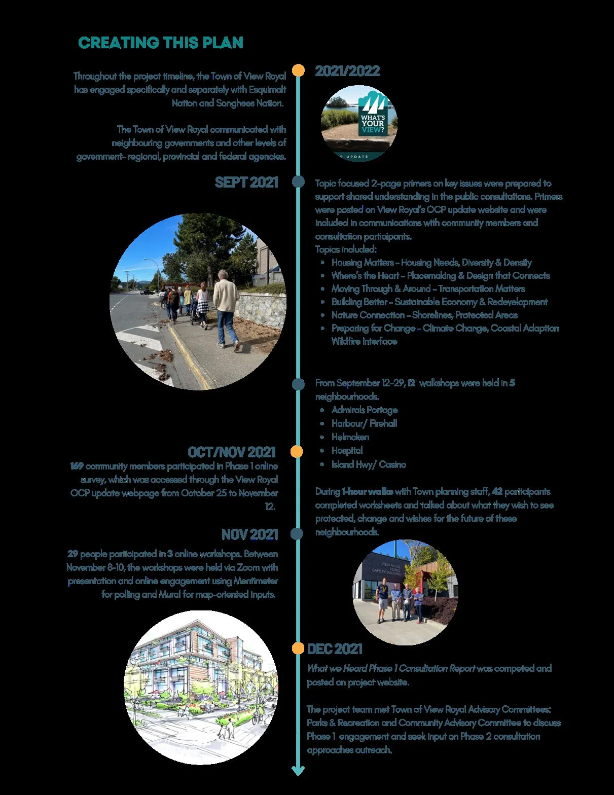
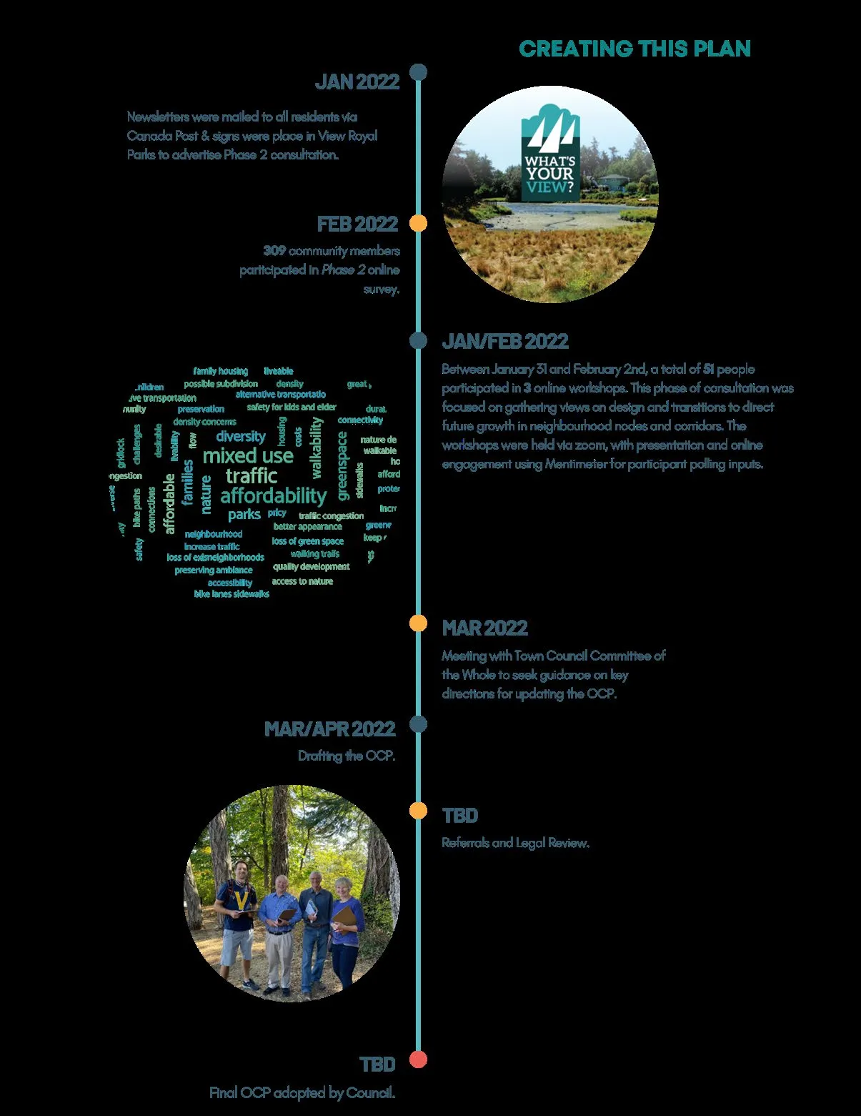
Based on the anticipated project timeline, we are on track to bring a final version forward in early June, giving staff time to prepare the necessary bylaw documents, and subject to Council direction, to schedule a public hearing. Referrals to outside agencies, adjacent municipalities, and comment by the Agricultural Land Commission would occur once a final draft is ready for circulation.
What Changed?
At the outset of the project Council agreed that this was an update of the 2011 plan, with a few strategic focus areas: Climate Change, Transportation, and additional attention to transition areas between higher intensity corridors and nodes and the surrounding neighbourhood. Information from the Draft Community Climate Action Strategy, the Housing Gaps and Needs Study, and the Land Economic Report were also integrated into the draft document. The draft presented today includes an increased emphasis on neighbourhood nodes and corridors in recognition that the desired Town Centre site is unlikely to be available over the life of this edition of the OCP.
As discussed at the outset of the process, an OCP must include certain content which is outlined in the Local Government Act. The draft presented today addresses all required content areas and includes policy related to the social needs, well-being and social development, and strong statements regarding preservation and protection of the natural environment. Topics that were referred to the process such as bird-friendly design, building energy efficiency and more have also been incorporated into policies and where appropriate, Development Permit Area Guidelines.
The Regional Context Statement has been updated to reflect the content of the plan; however, it is not final until the Board of the Capital Regional District have accepted it.
Plan Structure
The overall structure of the plan has not changed significantly. the document is slightly shorter as background content relating to individual neighbourhoods has been removed. The Vision has been refreshed reflecting an increased emphasis on climate change and placemaking, and the draft also includes a draft Regional Context Statement reflecting the updates in the plan and the points of alignment between the documents. 10 Goals that align with the vision are used as a framework for the updated OCP document.
Data and statistics about the Town have been updated to reflect the 2016 census, and background reports such as the Housing Gaps and Needs study, the draft Community Climate Action Strategy, and the Land Economics Study. Unfortunately, limited 2021 Census data is available and for consistency we are using the 2016 data. Staff will update our community profile information once the entire 2021 Census data set is available.
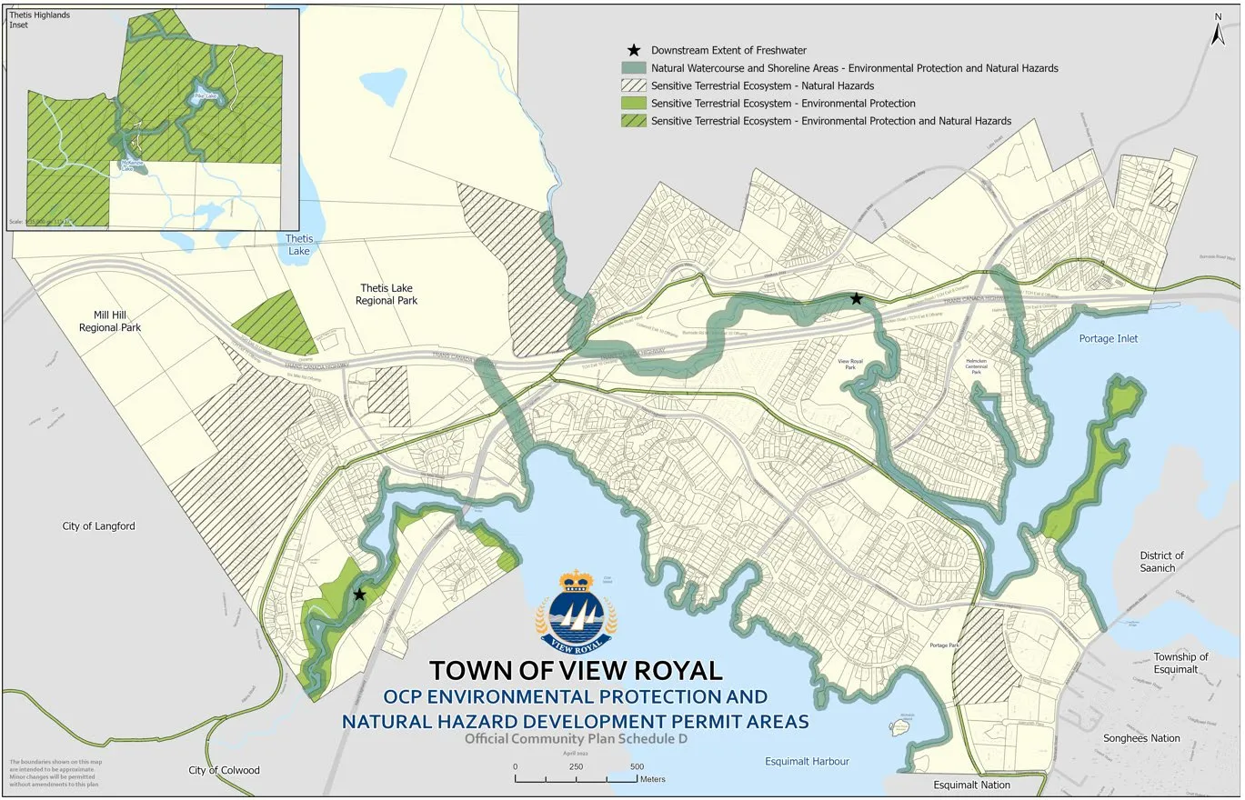
The chapter headings are retained from the 2011 document, and we have taken efforts to ensure that the web version and pdf version of the document will be easily navigable (without substantial scrolling!). One change that staff are particularly proud of is with respect to our maps. All the maps have been produced in house using our GIS system, and we have made efforts to improve the legibility of mapping particularly for those with visual impairments like colour-blindness.
Community Development Framework
The overall Community Development Framework is largely the same. We continue to emphasize corridors, gateways, and neighbourhood nodes, and have also recognized that the transition between these areas and surrounding neighbourhoods is important. The most meaningful change since 2011 is that the Town has few greenfield sites left, which means that most future community change will result from the redevelopment of existing sites.
Mapping changes highlight that there are areas of transition between the corridors and nodes that support redevelopment, and the adjacent neighbourhoods. Of note, there is language in the draft plan that would allow consideration (through the rezoning process) of carriage homes/garden suites on existing residential parcels. We anticipate future work (through plan implementation) to develop detailed guidelines to further shape this form of infill to minimize disruption in neighbourhoods. Council and the community will also note that language aimed at fostering strong relationships with the Songhees Nation and Esquimalt Nation are woven into multiple sections of the plan.
[Figure 2: 2011 OCP Land Use Framework]
Land Use and Urban Design
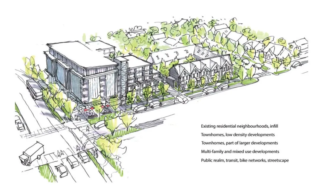
This section of the OCP takes most of the content from the 2011 OCP and adds more of an Urban Design focus. There is a greater emphasis on the importance of design transitions between different land uses, and the corridors and nodes now illustrate a transition area. These transition areas reflected in land use designation maps with changes to land use designations on the periphery of neighbourhood nodes and corridors. This section also include language regarding climate change and notes the strong connection between land use, transportation, and climate.
The draft includes policy language about the future of corridors/gateways such as the Eastern, Helmcken and Western Gateways corridors. These designations and policies support a commercial future on the Western gateway/corridor, more residential on the Helmcken Gateway, and Mixed Use on the Eastern Gateway.
The updated plan continues to conserve large lot residential areas by considering limited opportunities for infill such as carriage homes/garden suites and duplexes. These would only be achieved through a rezoning process.
As an example, the Helmcken-Harbour Community Corridor transition area results in a slight land use designation shift from Large Lot Residential to Residential along the southern edge. This shift is consistent with the information previously presented to Council regarding urban design and supports gentle transitions between land uses.
Climate Change
The topic of climate change has been woven throughout the plan and is reflected in policies in almost every chapter. We are emphasizing topics like low carbon and active transportation, energy efficient buildings and considering the impact of climate change on waterfront lands and lands near forests and streams.
Transportation
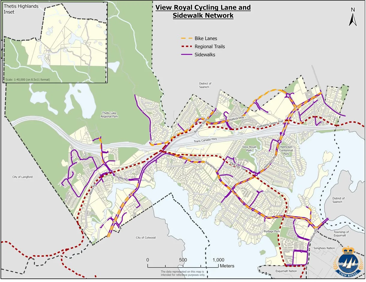
On the transportation side, we recognize that there is still much that can be done to encourage people to make different choices for how they move around, and that the Town will continue to prioritize local transportation needs over regional commuter pressures. The Active Transportation Network Strategy is a key implementation action of the OCP and connects to land use. Updated mapping of cycling and pedestrian routes highlights some of the gaps that will benefit from attention in the Active Transportation Strategy.
New Development Permit Areas
The final piece of work that is still underway is refining our Development Permit Areas (DPA’s). Two new DPA’s are proposed—an Intensive Residential Development, and a specific Natural Hazards Wildfire Interface DPA. The Intensive Residential DP area is proposed to apply to all Residential and Large Lot Residential properties, however detached residential (single family on lots larger than 450m2) will not require a DP. This DP designation is intended to capture changes like carriage homes (on Large Lot Residential), duplexes and small-scale townhouses or row homes on residential lands. It recognizes that these uses are already considered in the 2011 OCP for Residential lands and would only be triggered if lands are rezoned for housing with multiple units.
The new Hazard Lands Development Permit area is intended to capture areas that are immediately adjacent to forested areas and ensure that redevelopment or modification of the houses or landscaping meets Fire Smart standards. Designation of these areas serves two purposes—providing better guidance to homeowners where exterior changes are made and ensuring that risks for fire spreading to park areas are managed. Staff recommend that this Development Permit be delegated to staff in situations where the Hazard Lands DPA is the only DPA category that applies to a property.
NEXT STEPS:
The document being presented today is a draft and is still subject to refinement and change. Additional refinements to Development Permit Areas for Intensive Residential and Hazard Lands are still needed, and there are placeholders for several photos. We continue to work out formatting issues and need to complete a review for consistency within the document. A legal review is also planned once the document is finalized.
Through regular check ins with Council and Committee, and through posting materials on the Town website on a regular basis, we have made strong effort to keep Council and the community engaged throughout this project. Presenting the first draft of the Official Community Plan is a major milestone, and it is at this point that all the ideas, visions and feedback from the community coalesce into a single document. Staff recommend that the draft be posted on the Town’s website with an opportunity for feedback. This feedback information will be gathered by staff and presented to Council in June, along with any recommendations for changes to the draft.
Staff also suggest that Council's Advisory Committees be engaged in reviewing the draft at their meetings later in May, with feedback to come forward with other public comment in June.
At the outset of the process to review the OCP, Council considered community engagement along with engagement of outside agencies, ministries, School Districts, and First Nations. These groups were invited to participate at the outset, and best practice would be to send a draft plan to them for comment once a final draft is accepted. Normally this occurs after first reading, and outside bodies are given 30 days to provide comment.
The Local Government Act includes regulations for the adoption of an Official Community Plan, which is adopted as a bylaw:
477 (1) An official community plan must be adopted by bylaw in accordance with this section. (2) Each reading of a bylaw under subsection (1) must receive, (a)in the case of a municipal bylaw, an affirmative vote of a majority of all council members, and (b) in the case of a regional district bylaw, an affirmative vote of a majority of all directors entitled under Division 3 [Voting and Voting Rights] of Part 6 [Regional Districts: Governance and Procedures] to vote on the bylaw. (3) After first reading of a bylaw under subsection (1), the local government must do the following in the indicated order: (a)first, consider the proposed official community plan in conjunction with (i) its financial plan, and (ii) any waste management plan under Part 3 [Municipal Waste Management] of the Environmental Management Act that is applicable in the municipality or regional district; (b)next, if the proposed official community plan applies to agricultural land in the agricultural land reserve, refer the plan to the Provincial Agricultural Land Commission for comment; (c)next, hold a public hearing on the proposed official community plan in accordance with Division 3 [Public Hearings on Planning and Land Use Bylaws] of this Part.
Once feedback from the community has been received and a final draft is given first reading, Council will need to consider the OCP in conjunction with the Financial Plan, the Waste Management Plan, and then we will need to refer the document to the Provincial Land Reserve Commission for comment as there are parcels that are within the Agricultural Land Reserve.
After those steps are done, Council can schedule a Public Hearing, and notice to the community will be made.
After the OCP is adopted, the Town will then need to engage with the CRD for approval of the Regional Context Statement.
RECOMMENDATION:
That Committee of the Whole receive the report titled ‘Draft Official Community Plan’ from the Director of Development Services.
AND THAT Council schedule a dedicated special Council meeting for the purpose of Council review of the Draft OCP prior to referral to Council’s Advisory Committee’s.
SUBMITTED BY: L. Chase, Director of Development Services
REVIEWED BY: K. Anema, Chief Administrative Officer
Attachment: Draft Official Community Plan
Document Images
(7)


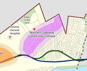
Figure 1 - 2022 Draft OCP Land Use Framework Schedule highlighting the Northern Gateway Community Corridor
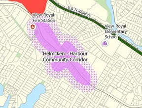
Figure 3 - 2022 Community Development Framework Excerpt showing the Helmcken - Harbour Community Corridor
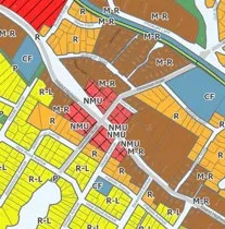
Figure 4 - 2022 Land Use Designation Excerpt showing various residential and mixed-use categories