Planning & Development Report: DEVELOPMENT PERMIT APPLICATION 2021/03 – 221 ATKINS ROAD
A staff report regarding a revised two-lot residential subdivision proposal at 221 Atkins Road, evaluating its compliance with riparian area and steep slope development permit guidelines.
TOWN OF VIEW ROYAL
Planning & Development Report
TO: Committee of the Whole DATE: February 3, 2022 FROM: J. Chow, Senior Planner MEETING: February 8, 2022 FILE NO.: 3060-20-2021/03
DEVELOPMENT PERMIT APPLICATION 2021/03 – 221 ATKINS ROAD
RECOMMENDATION:
THAT the report dated February 3, 2022 from the Senior Planner titled “Development Permit Application 2021/03 – 221 Atkins Road” be received for information.
CHIEF ADMINISTRATIVE OFFICER’S COMMENTS: I concur with the recommendation.
DIRECTOR OF DEVELOPMENT SERVICES’ COMMENTS: I concur with the recommendation.
DIRECTOR OF ENGINEERING’S COMMENTS: I concur with the recommendation.
PURPOSE:
To present a revised proposal for a two-lot residential subdivision within the Natural Watercourse and Shoreline Areas and the Sensitive Terrestrial Ecosystems development permit areas.
BACKGROUND:
The 1.286 ha extensively treed property backs onto Millstream Creek and is on two levels separated by a sloping bank as shown in Figure 1. At the street level there is a detached dwelling that is several decades old. The grade then drops 6 to 7 metres at a ~2:1 slope to the Millstream Creek level. There is a house at the top of the bank along Atkins Road.
Records indicate that landslides occurred on the property in 1973 and February 2002 and that the slope was remediated in 2003. At that time, Covenant EV105849 was registered in favour of the Town to require geotechnical certification for any new buildings and structures, and alterations to existing building and structures.
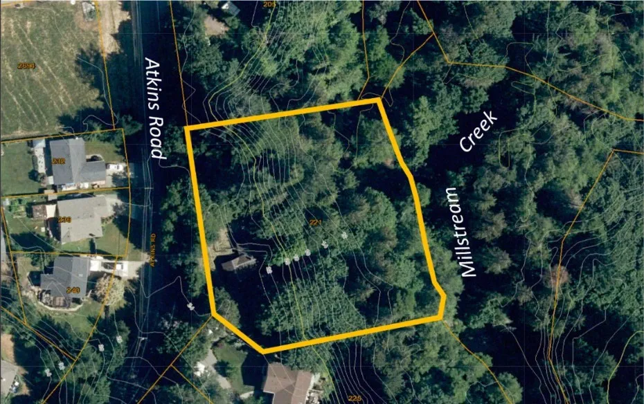
Figure 1. Air photo of subject property with 1m contours
The initial proposal for this application was presented at the May 11, 2021 Committee of the Whole meeting. The development concept was for three lots as shown in Figure 2. Reports were provided that set out recommendations to minimize impacts on riparian areas, trees, and slope stability. While the measures addressed applicable development permit guidelines for protection of the natural ecosystem and development on steep slopes, the Committee considered that requested variances to the shape and depth of the remaining buildable areas were not suitable for three lots.
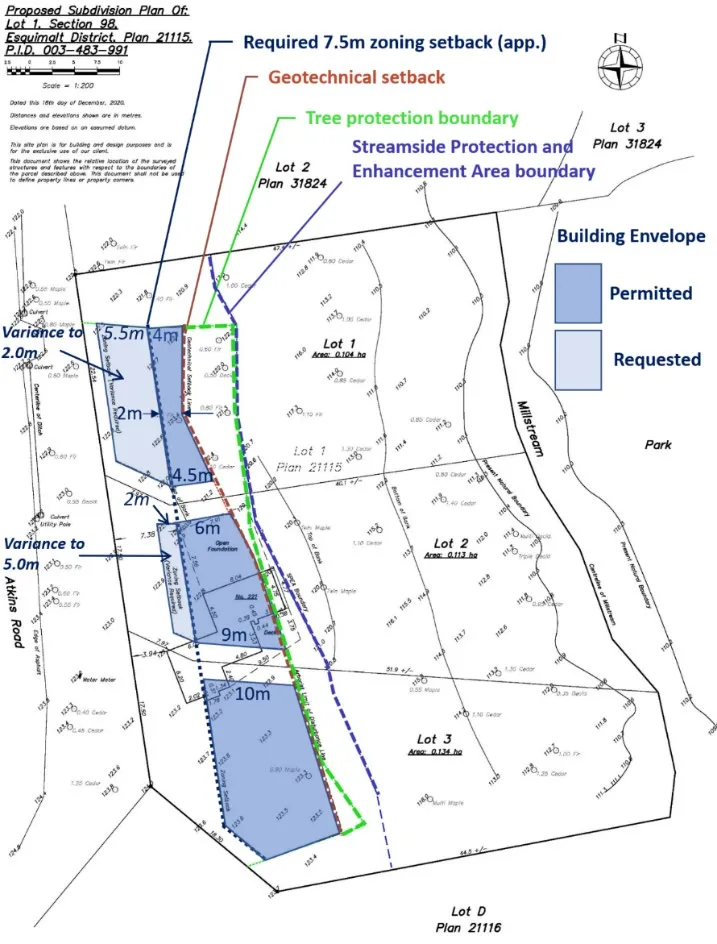
Figure 2. Permitted and requested setbacks Source: Attachment 4 (coloured annotations by staff)
PROPOSAL:
The applicant has revised the proposal as shown in Figure 3 to a two-lot subdivision. The application is for a development permit addressing riparian area and steep slope issues to facilitate one additional lot as shown in Figure 3. Part of the existing dwelling would be removed so that the remainder of the dwelling will comply with setback requirements to the new internal shared lot line.
In support of the application the following is provided as attachments to this report:
- Location plan
- Applicant letter and development permit rationale
- Petitions of support
- Subdivision Plan
- Riparian Areas Report
- Servicing concept
No variances are required.
DISCUSSION:
Key issues include the following:
- How does the proposal address the relevant development permit guidelines?
- How does the proposal comply with zoning requirements?
- What are the next steps toward Council consideration of the proposal?
1. Development Permit Area Guidelines
The proposal is subject to the guidelines of the Natural Watercourse and Shoreline Areas (within 30m of the natural boundary of Millstream Creek) and the Sensitive Terrestrial Ecosystems development permit areas, which respectively aim to minimize impacts on the Millstream Creek riparian area and the slope.
Figure 3 shows three boundaries for the siting of buildings to protect ecologically sensitive and steep slope hazard lands from development:
- Streamside Protection and Enhancement Area
- Geotechnical setback from the top of bank
- Tree protection boundary
Zoning setbacks from lot lines provide a fourth boundary. The most restrictive boundary applies and there are suitable building envelopes on each lot.
Staff considers that the proposal complies with the development permit area guidelines based on and conditions of development outlined in the professional reports and materials provided. The land within the Streamside Protection and Enhancement Area and along the slope will be largely undisturbed except for pipes to carry storm water from each lot to Millstream Creek.
The geotechnical engineering report has not been updated since the 2021 proposal, but the geotechnical setback remains the same and requirements to mitigate the impacts on the slope continue to apply.
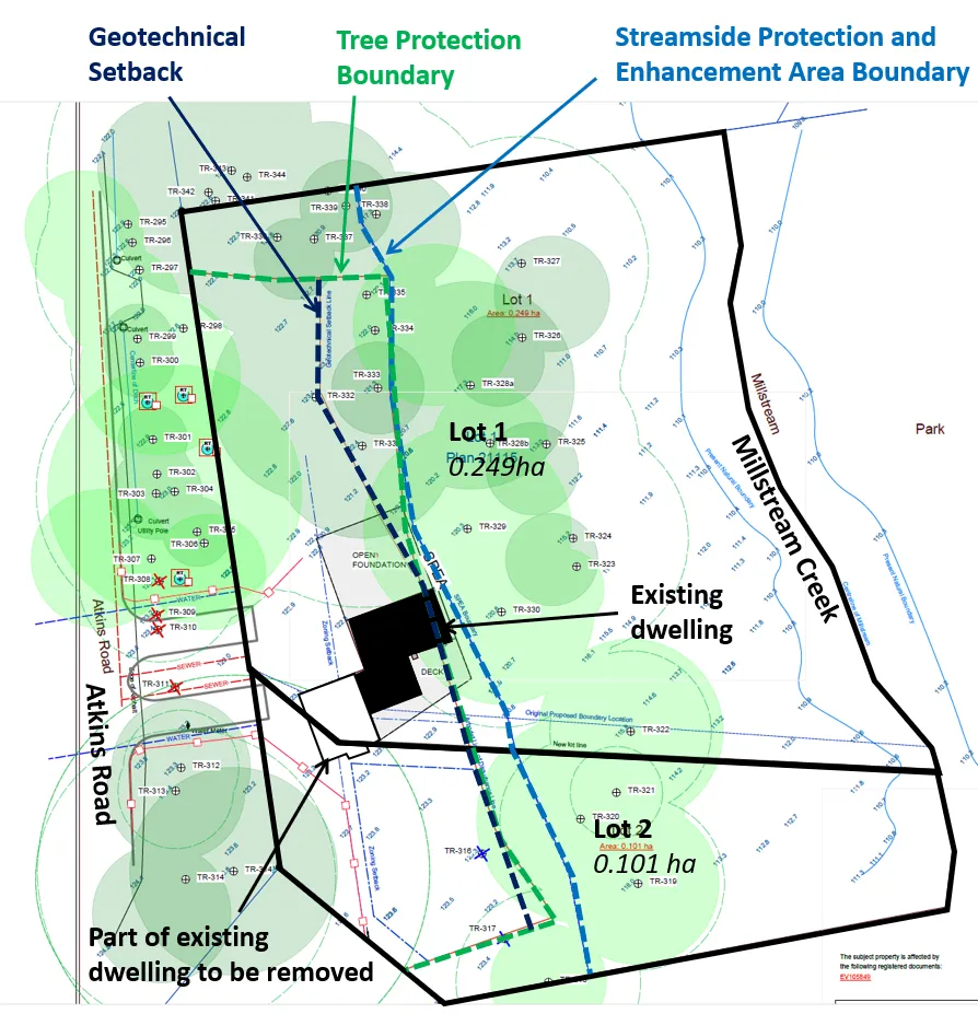
Figure 3. Site Plan
The Riparian Areas Regulations (RAR) report (Attachment 5) addresses the guidelines by establishing a Streamside Protection and Enhancement Area on the property and providing recommendations that would be incorporated as conditions of the development permit for issues including the following:
- Trees a. No danger trees were noted on site. b. Arborist supervision of clearing, servicing and construction to monitor tree protection (fencing and other measures required) and potential windthrow.
- Slope stability a. A geotechnical setback has been established. b. Minimize vegetation disturbance near the slope crest. c. Construct landscaping features so that surface runoff is not concentrated discharge at the slope crest. d. Supervision of excavation by a qualified professional e. Excavation cut slopes to be in a stable configuration (e.g., 1:1 slope) over the short to medium term in the event lots are not developed immediately. f. Construction and permanent fencing of the SPEA (a 'no disturbance' covenant is recommended by the Qualified Environmental Professional)
- QEP to be involved in preparing the sediment and erosion control plan.
- Storm water management a. Convey storm water into municipal storm drain or downslope by pipe. b. Maximize onsite infiltration if safe geotechnically.
While Millstream Creek shows indications of channel mobility within the ravine, the RAR report considers that floodplain issues regarding the proposed development and the creek are highly unlikely given the width of the calculated SPEA, the height of the ravine, and the proposed tree replanting on the ravine slope. The RAR report concludes there to be no undue hardship on the site buildability for the two proposed lots.
The municipal storm drainage infrastructure in the immediate area consists of a ditch along Atkins Road. The ditch only has capacity to carry road drainage. Servicing requirements are that there is to be no net increase in post-development storm water runoff entering the municipal storm drain system, so any stormwater runoff will have to be detained on site and/or piped through the SPEA to Millstream Creek. The RAR and geotechnical engineering reports allow for this and set out conditions to minimize impacts, such as revegetation and ensuring that the outlet will not exacerbate bank erosion. A conceptual design is not provided as part of the plans because the work can only be done through detailed design. In this is location it is essential the surface flows and infiltration be carefully controlled and balanced to preserve slope stability.
Other servicing requirements for water, sewer and the road frontage will be addressed through the subdivision application because they do not relate to or affect land within the development permit areas; however, the following should be noted:
- The arborists report (within Attachment 5) indicates that many of the roadside trees are in poor condition and should be replaced as part of the subdivision.
- The site is on a section of road where there is no municipal sewer. Some residents in the neighbourhood have expressed a desire for a sewer connection because their septic fields are aging, but there are no capital plans for expansion in this area. Since new development is required to connect to the sewer system, this development would extend the line by over 150m.
2. Zoning Requirements
The proposed lots would comply with the lot area and width requirements of the R-1 Detached Residential (Large Lot) zone.
| Required | Proposed Lot 1 | Proposed Lot 2 | |
|---|---|---|---|
| Lot Area | 1000m² | *2490m² | *1010m² |
| Lot Width | 17.5m | >40m | 17.5m |
* Need to confirm lot areas are land only
The 1968 subdivision creating this parcel shows the rear lot line following the centre line of Millstream Creek. This is unusual as foreshore areas beyond the natural boundary are “returned to the Crown” and not part of a lot. The size of the proposed lots appears to be based on land area only, but staff will confirm with the surveyor.
3. Next Steps
The application can be considered by Council once lot areas are confirmed.
RECOMMENDATION:
THAT the report dated February 3, 2022 from the Senior Planner titled “Development Permit Application 2021/03 – 221 Atkins Road” be received for information.
SUBMITTED BY: Jeff Chow, MCIP, RPP, Senior Planner
REVIEWED BY: Lindsay Chase, MCIP, RPP Director of Development Services
ATTACHMENTS
- Location plan
- Applicant letter and development permit rationale – January 31, 2022 (2 pages)
- Petitions of support
- Subdivision Plan, Wey Mayenburg Land Surveyors – December 18, 2020
- Riparian Areas Report, Stantec – January 28, 2022 (27 pages)
- Geotechnical reports, Ryzuk Geotechnical - March 15, 2019/ November 28, 2020 (5 pages)
- Servicing concept – Stantec, January 11, 2022
Document Images
(3)