Planning, Development & Engagement Report: REZONING APPLICATION 2022/04 – 335 STEWART AVENUE
Report on an application to rezone 335 Stewart Avenue to allow for an increase in the maximum floor area of a single-family dwelling.
TOWN OF VIEW ROYAL PLANNING, DEVELOPMENT & ENGAGEMENT REPORT
TO: Committee of the Whole FROM: Jeff Chow, Senior Planner DATE: November 1, 2022 MEETING DATE: November 8, 2022 FILE NO.: 3360-20-2022/04
REZONING APPLICATION 2022/04 – 335 STEWART AVENUE
RECOMMENDATION:
THAT the November 1, 2022 report from the Senior Planner titled “Rezoning Application 2022/04 – 335 Stewart Avenue” be received for information.
CHIEF ADMINISTRATIVE OFFICER’S COMMENTS:
I concur with the recommendation.
DIRECTOR OF DEVELOPMENT SERVICES’ COMMENTS:
I concur with the recommendation.
DIRECTOR OF ENGINEERING’S COMMENTS:
I concur with the recommendation.
PURPOSE OF REPORT:
To provide additional information on trees and the potential construction impacts for Rezoning Application 2022/04 for the property located at 335 Stewart Avenue, which is a proposal to rezone the subject property to increase the maximum floor area of an existing single family dwelling from 372m² to 550m².
BACKGROUND:
The approximately 3197m² parcel at the end of Stewart Avenue is located on the Esquimalt Harbour waterfront. The house was built in the 1930s and has a total floor area of approximately 211m².
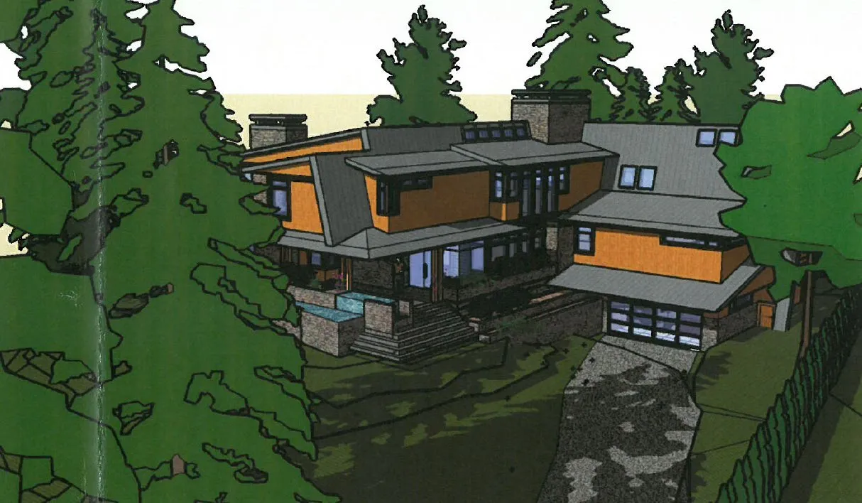
Figure 1. DP2010/03 - proposed house
Development Permit 2010/03 was approved in 2010 for the purpose of building a new house and landscaping. A rendering of the proposed house is shown in Figure 1. The permit also varied the maximum permitted floor area from 372m² to 695m² and the maximum permitted building height from 7.5m to 8.45m. The proposed house was not built, and the development permit has lapsed.
The current Zoning Bylaw was adopted in 2014 and the floor area is now included under density provisions, meaning a variance cannot be used to alter the density. Rezoning is now required to increase the size of a house on this lot.
In 2011, Development Permit 2010/08 was approved to construct a wharf and access stairs in conjunction with a dock. These works were completed.
In July 2021, Development Permit 2021/07 was approved to permit a boathouse accessory structure on the wharf, which has been constructed as shown in Figure 2 below.
The current application was introduced at the July 12, 2022 Committee of the Whole meeting.
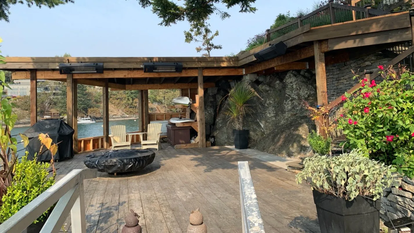
Figure 2. DP2021/07 Boathouse
PROJECT INFORMATION:
Proposal
The subject property is zoned R-1: Detached Residential (Large Lot) which permits a maximum permitted floor space of 372m² per lot and a floor space ratio of 0.42:1.
The proposal is to rezone to a new zone to permit a maximum permitted floor space of 550m² per lot so that the applicant can construct a building addition. At 550m² of floor space, the floor space ratio would be 0.18:1 for this lot.
Development Permit 2010/03 granted a variance to increase the maximum floor space from 372m² to 695m². The DP has lapsed. The current Zoning Bylaw now defines maximum floor space as a density measure so it cannot be varied and can only be increased through rezoning.
Development Concept
The proposed development concept to construct a two-storey addition is illustrated in Figures 3 and 4 with more details in Attachments 4 and 5. Form and character requirements do not apply to detached residential dwellings, but the following proposed design aspects of the addition should be noted:
- the butterfly roof style and an existing roof over a patio
- natural stone cladding to match the existing dwelling
- few windows on the north wall to minimize privacy impacts on the neighbouring parcel.
The siting of the proposed addition would comply with the 2.0m side yard setback requirements of the existing R-1 zone. The location was chosen to avoid archaeological sites on the property and remain outside of the Natural Watercourse and Shoreline development permit area that applies to land within 15.0m of the natural boundary.
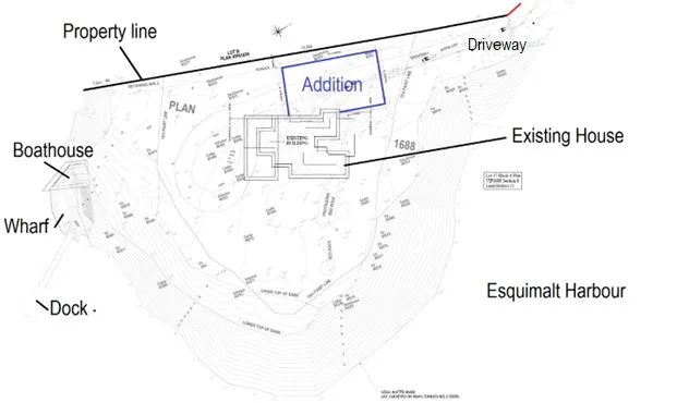
Figure 3. Site Plan
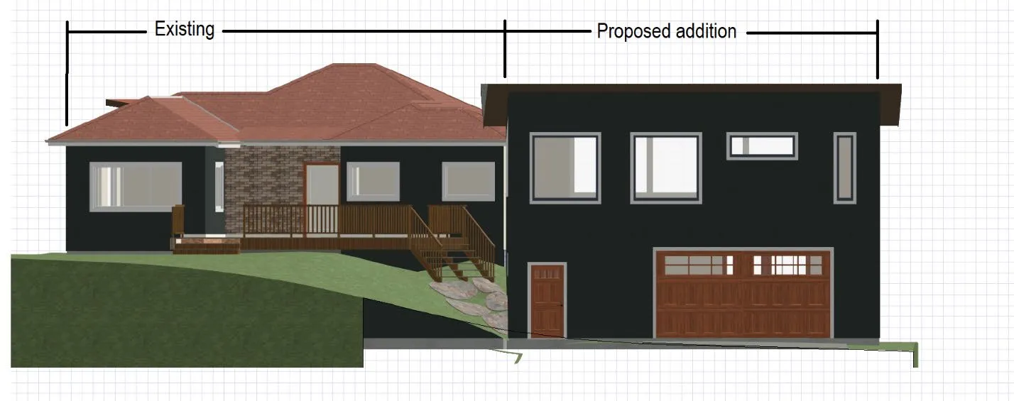
Figure 4. Front view
While the building design may continue to evolve after rezoning, the building must comply with the 2.0m side yard setback, 7.5m building height, and other zoning requirements. The proposed building footprint is shown in Figure 3 and marked out in Figures 5 and 6.
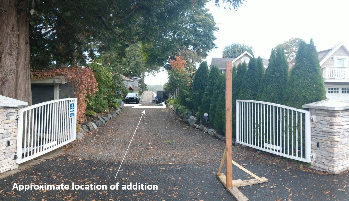
Figure 5. Street view
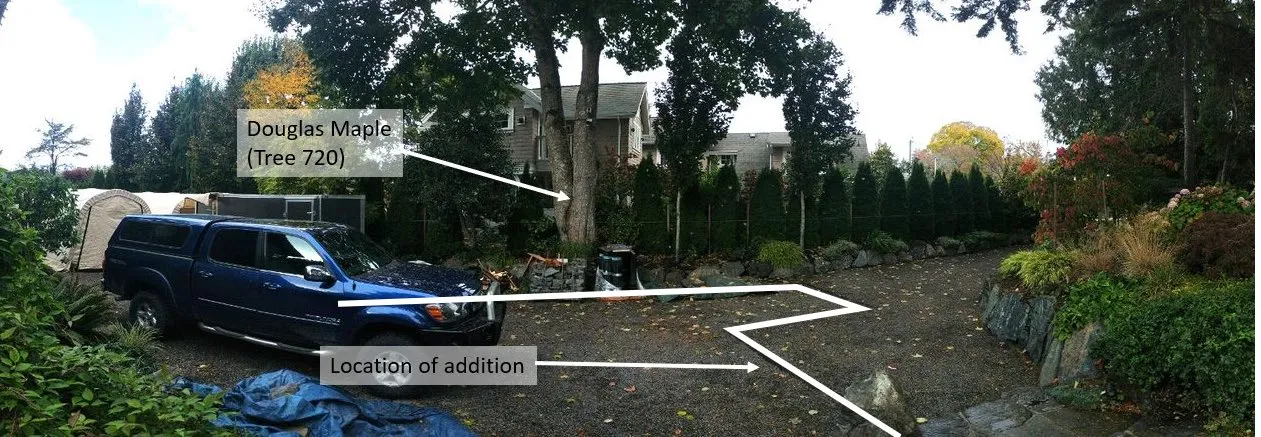
Figure 6. Wide angle view to north. Note Douglas Maple.
DISCUSSION:
Official Community Plan Context
The property is within a neighbourhood with the Large Lot Residential land use designation, which supports detached homes on large lots, up to 2.5 storeys.
The Natural Watercourse and Shoreline Areas development permit area applies to land within 15m of the natural boundary. The proposed building location is not within this development permit area. There are no form and character development permit requirements applicable to this type of detached residential development.
Proposed Zone
The proposal is to create a new Comprehensive Development zone to increase to the maximum floor space from 372m² per lot to 550m² but otherwise carry over the other zoning requirements from the current R-1: Detached Residential (Large Lot) zone (Attachment 6).
In Attachment 3, the applicant provides information comparing the proposed lot coverage to other houses in the neighbourhood. While the proposed rezoning would permit a larger building than is permitted on other lots on this street, the lot coverage and floor space ratio would be relatively low.
The following table compares the key existing R-1 zone requirements to the proposed zone and the development concept:
| Description | R-1 Zone | Proposed Zone | Development Concept |
|---|---|---|---|
| Lot Size | |||
| Lot Size with Sanitary Sewer Service, minimum | 1000m² | 1000m² | 3197m² |
| Lot Size without Sanitary Sewer Service, min. | 8 ha | 8 ha | n/a |
| Lot Width, minimum | 17.5m | 17.5m | 12.0m (existing) |
| Lot Density | |||
| Principal Buildings per lot, maximum | 1 | 1 | 1 |
| Secondary Suites per lot, maximum | 1 | 1 | 0 |
| Building Floor Area, maximum | 372m² | 550m² | 550m² |
| Floor Space Ratio | 1:0.42 | 1:0.42 | ~1:0.18 |
| Lot Coverage, maximum | 40% | 40% | ~11% |
| Impermeable Surface Coverage, maximum | 60% | 60% | ~20% |
| Building Size | |||
| Building Height, maximum | 7.5m | 7.5m | Tbd |
| Building Width, minimum (horizontal dimension of a building) | 6m | 6m | 3.5m (existing) |
| Siting of Principal Buildings and Other Structures | |||
| Front Lot Line Setback, minimum | 7.5m | 7.5m | 24.0m |
| Rear Lot Line Setback, minimum | 7.5m | 7.5m | 30.0m |
| Side Lot Line Setback, minimum | 2m | 2m | 2m |
| Flanking Lot Line Setback, minimum | 4.5m | 4.5m | n/a |
Site Servicing
The proposed rezoning is in accordance with the OCP Residential Large Lot land use designation and thus servicing was compared to the Town’s storm drain and sanitary sewer master plans with respect to system capacities. The proposed increase in density of this development is expected to have a negligible impact to the sanitary and storm drain infrastructure. However, onsite stormwater management will still be required in accordance with the Subdivision and Development Servicing Bylaw and a stormwater management plan is to be provided prior to issuance of the Building Permit.
Servicing was also compared to the Town’s Transportation Master Plan. The proposed increase in density of this development is expected to have a negligible impact on the operation of the Town’s system. No upgrades to the Town’s systems are recommended beyond standard servicing requirements. Furthermore, there are no additional frontage requirements as the ultimate frontage at this property has already been built out.
Tree Impacts
The Tree Protection Bylaw requires protection of retained trees from construction impacts. The arborist report (Attachment 7) indicates the following:
- there are 14 trees (3 protected trees) and 27 hedging cedars (unprotected)
- no trees or hedging cedars are proposed for removal
- the proposed addition would have a slab on grade foundation in an area that is currently a gravel driveway
- minimal impacts from footing excavation and construction can be anticipated if recommendations for tree protection fencing, arborist supervision, special excavation techniques, etc. are followed
- footings are proposed within the drip line of a 99cm dbh Douglas Maple (Tree 720) (shown in Figure 6), and significant root pruning may be required. Excavation for footings within the Protected Root Zone should be done by hydro-vacuum truck in the fall/winter months with supervision and any pruning of roots and canopy to be done by an ISA certified arborist with Tree Risk Assessment Qualifications.
A nearly 0.5m test hole was dug in the gravel driveway area between the Douglas Maple (Tree 720) and the proposed addition. The photo documentation in Attachment 8 indicates this driveway area is compacted and contains rocky soil with little dirt. There were no tree roots found within the excavation.
As the work will be within the protected root zone of some protected trees the Applicant must apply for a tree permit prior to issuance of a building permit.
Conclusion
The proposal to increase the floor area of a single-family dwelling from 372m² to 550m² is supportable as minimal streetscape impacts are anticipated given the location of the existing house, surrounding vegetation screening and the large 24m setback from the front lot line.
The location of the proposed building addition is supportable for the following reasons:
- it is within the existing gravel driveway area where it would impact the fewest number of trees
- it is outside of the 15m Natural Watercourse and Shoreline development permit area
- away from several archaeological sites on the property
- it complies with the 2.0m side yard setback requirement of the R-1 zone
- the arborist report provides tree preservation and mitigation measures to preserve vegetative screening in the side yard adjoining the sole neighbouring property.
NEXT STEPS:
Pending comments from the Committee, a bylaw can be introduced for consideration at an upcoming Council meeting. Staff intends to recommend that a covenant be registered concurrent with fourth reading of the bylaw to require that construction and mitigation measures be implemented in accordance with the arborist report to mitigate potential tree impacts.
RECOMMENDATION:
THAT the November 1, 2022 report from the Senior Planner titled “Rezoning Application 2022/04 – 335 Stewart Avenue” be received for information.
ATTACHMENTS:
- Subject Property Map
- Subject Property Orthophoto
- Letter from Applicant - April 20, 2022 (9 pages)
- Site Plan
- Renderings (6 pages)
- Zoning Bylaw excerpt - R-1 Zone (2 pages)
- 335 Stewart Avenue Tree Protection Plan Report – Peter McAra ISA and Trent Skaar ISA, Bartlett Tree Experts, September 15, 2022 (22 pages)
- Email from Sol Landscaping, September 22, 2022 (9 pages)
Document Images
(3)