TOWN OF VIEW ROYAL PUBLIC HEARING REPORT - REZONING APPLICATION 2021/01
Staff report summarizing the proposal to rezone 167, 169, and 171 Island Highway to a new Comprehensive Development zone (CD-27) for an 82-unit apartment building.
TOWN OF VIEW ROYAL PUBLIC HEARING REPORT
TO: Council FROM: J. Chow, MCIP, RPP, Senior Planner DATE: January 27, 2022 MEETING DATE: February 1, 2022 FILE NO.: 3360-20-2021/01
ZONING BYLAW NO. 900, 2014, AMENDMENT BYLAW NO. 1083, 2022 TO REZONE 167, 169, AND 171 ISLAND HIGHWAY TO “CD-27: COMPREHENSIVE DEVELOPMENT (ISLAND HIGHWAY – PORTAGE)”
RECOMMENDATION
THAT the report dated January 27, 2022 from the Senior Planner titled “Zoning Bylaw No. 900, 2014, Amendment Bylaw No. 1083, 2022 to Rezone 167, 169, and 171 Island Highway to CD 27: Comprehensive Development (Island Highway – Portage)” be received.
CHIEF ADMINISTRATIVE OFFICER’S COMMENTS
I concur with the recommendation.
DIRECTOR OF DEVELOPMENT SERVICES’ COMMENTS
I concur with the recommendation.
DIRECTOR OF ENGINEERING’S COMMENTS
I concur with the recommendation.
PURPOSE OF REPORT
To summarize information relating to Zoning Bylaw No. 900, 2014, Amendment Bylaw No. 1083, 2022 to rezone 167, 169, and 171 Island Highway to a new zone, CD-27: Comprehensive Development (Island Highway - Portage), along with updated information on community amenity contributions.
BACKGROUND
The 3780 m² site is comprised of three detached residential properties that are zoned R-1 B Detached Residential (Medium Lot). The lots are designated Mixed Residential in the Official Community Plan, which supports multifamily use.
The site is bounded by Portage Park on the east, View Royal Town Hall on the south (where there is a trail leading to the park and the E&N Regional Trail), Four Mile Brewpub to the north, and Island Highway.
The application was introduced at the September 14, 2021 Committee of the Whole meeting, with further discussion at the December 14, 2021 Committee of the Whole meeting on building height, trees, landscape screening, access and egress, compliance with parking requirements, the relationship to Portage Park, and the community amenity contribution. First and second readings of Zoning Bylaw No. 900, 2014, Amendment Bylaw No. 1083, 2022 were made at the January 18, 2022 Committee of the Whole meeting.
PROJECT INFORMATION
The proposal is to rezone the properties from R-1 B Detached Residential (Medium Lot) to a new zone permitting multifamily residential use. The rezoning application addresses zoning issues of land use, density, and standards for lot coverage, percentage of impervious surface, the height and siting of buildings in general. A development concept has been provided but consideration of the specific design would only be formally considered by Council in a development permit application if the rezoning is approved.
The following attachments to this report provide more information on the proposal:
- Subject Property Map
- Subject Property Orthophoto
- Letter from Applicant (site data not current)
- Development Concept Architectural Plans
- Landscape Plan
- Official Community Plan Policies
- Traffic Impact Assessment
- Servicing Brief
- Transportation Demand Management study
- Renderings
- Letter from property owner on community amenity contributions (new)
Development Concept
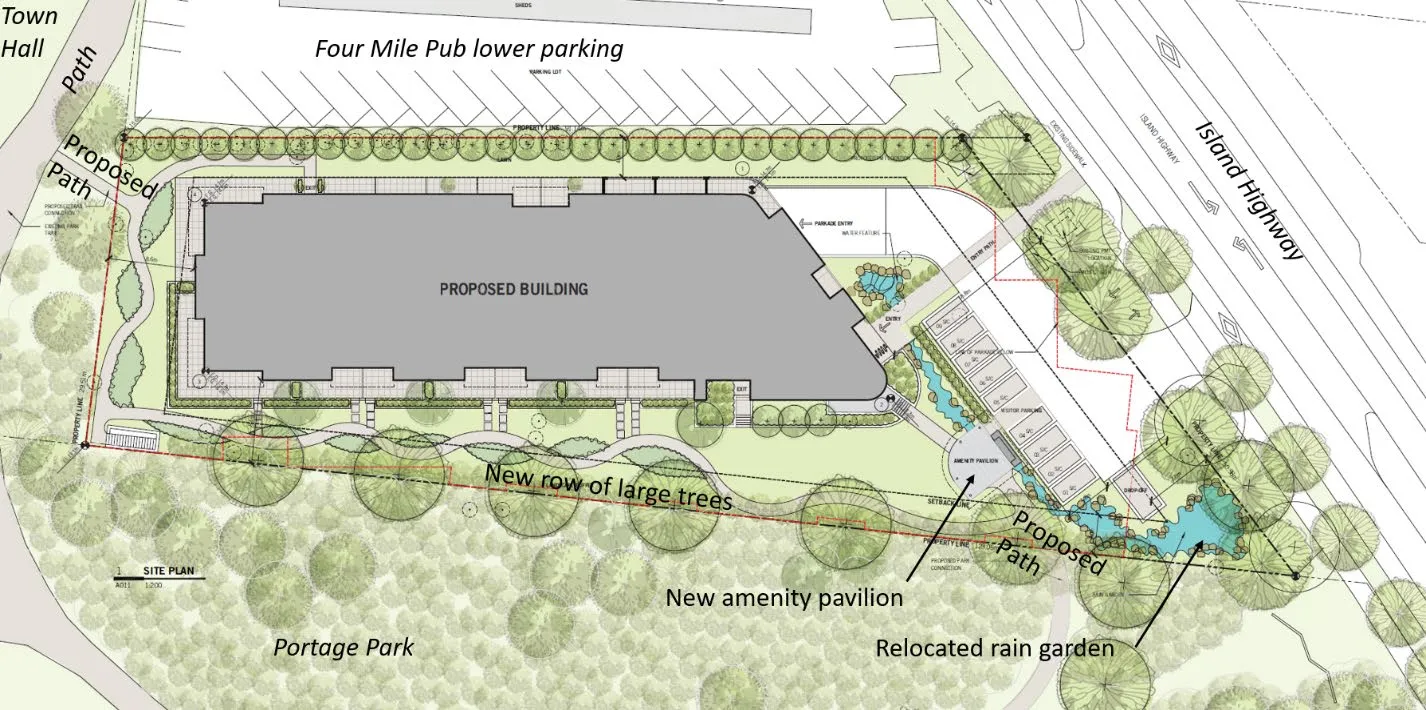
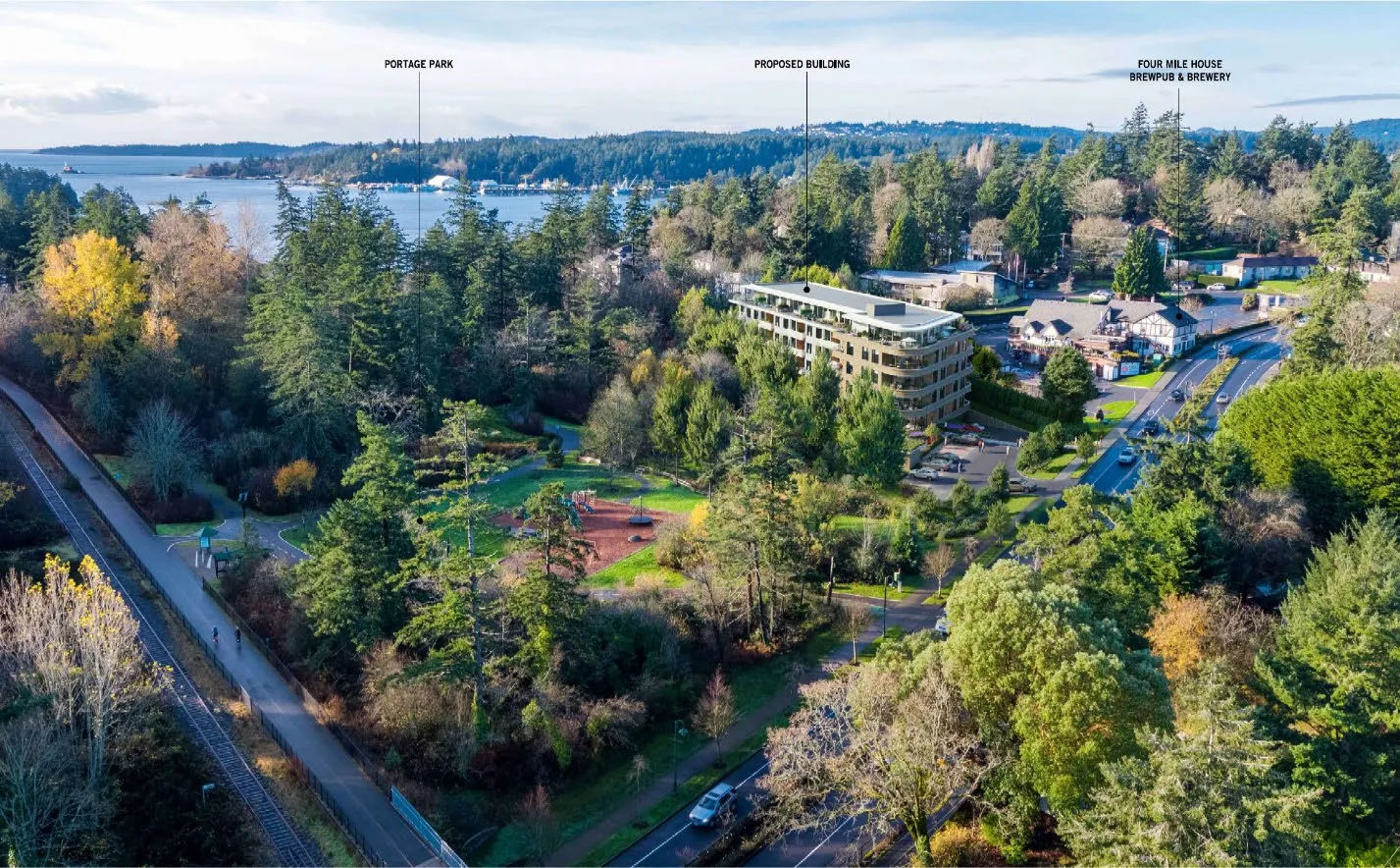
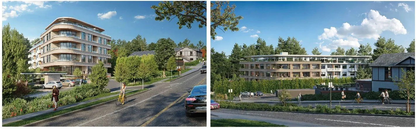
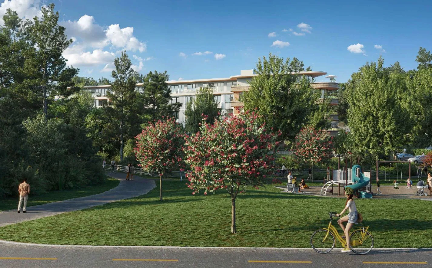
The development concept (Attachments 4 and 5) is for a five-storey 82-unit apartment building with the top floor set back as shown in Figures 1 - 3. Nine visitor parking spaces are proposed to be located at grade near the building entrance (previously six) plus one pickup/loading space, which acknowledges the growing trend for home delivery of goods and meals.
The applicant initially presented the development concept at the July 20, 2021 Council meeting (see Figure 5). Council members remarked on the favourable location and provided their individual comments that included tree retention, parking, massing, density, height, setbacks, and a desire to minimize impact on Portage Park.
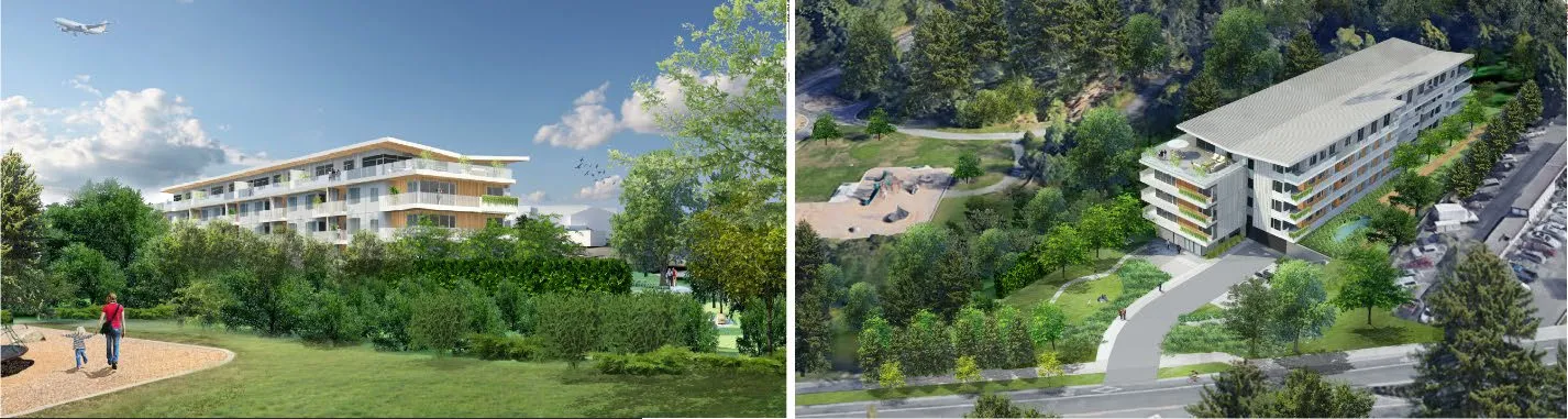
The plans presented in Attachment 4 and Figures 1-4 reflect the applicant’s ongoing revisions in response to comments. The most significant change from the July 20, 2021 Council meeting is an increased setback from the east side lot line abutting Portage Park from 4.0m to 8.4m and the use of sand-coloured brick veneer and flat roof for a more classic rather than modern appearance. Key changes since the September 14, 2021 Committee of the Whole meeting include:
- Number of units reduced from 86 to 82
- Increase in number of three-bedroom units from 1 to 3
- New on-site amenity pavilion for residents of the property
- Relocation of rain garden closer to Island Highway
- Visitor spaces increased from six to nine
- Six onsite trees on along the Portage Park property line to provide visual screening
- Provision of four trees in Portage Park for additional screening of the development (this is not an amenity – it is to reduce the visual impact from the park and will be secured by covenant)
Building Data Details
| Item | July 2021 | September 2021 | Current |
|---|---|---|---|
| Units | 87 | 86 | 82 |
| Floor Space Ratio | 1.6:1 | 1.54:1 | 1.6:1 |
| Parking spaces* | 105 | 102 | 103 |
| Front yard setback | 7.0m | 18.8m | 18.8m |
| West side yard (4mile Pub) | 4.0m | 4.0m | 4.0m |
| East side yard (park) | 4.0m | 8.4m | 8.4m |
| East side yard (park) | n/a | n/a | amenity pavilion 4.0m |
| Rear yard (Town Hall) | 7.5m | 8.6m | 8.6m |
| Rain garden | North of building | South of building | Southeast corner |
- Including one drop-off/loading space
Unit Mix
| Units by number of bedrooms | September 2021 | Current |
|---|---|---|
| 1-bedroom units | 69 | 65 |
| 2-bedrooms units | 16 | 14 |
| 3-bedroom units | 1 | 3 |
Site Data Summary
| September 2021 | Current | |
|---|---|---|
| Site Area | 3780 m² | 3780 m² |
| Floor Area | 5900 m² | 6026 m² |
| Floor Space Ratio | 1.54:1 | 1.6:1 |
| Units/Hectare | 227.5 | 217.0 |
| Building Height | 17.7 m | 17.8 m |
| Storeys | 5 | 5 |
| Site Coverage | 34% | 34% |
| Units Proposed | 86 | 82 |
| Vehicle Parking | 102 (95 required) | 103 (91 required) |
| Secure Bicycle Parking | 86 (86 required) | 82 (82 required) |
To ensure that the development concept can be realized, a covenant will be registered to secure the following:
- The three lots are not to be sold independently
- The three lots are to be consolidated prior to building permit issuance
Proposed Zone
The CD-27: Comprehensive Development (Island Highway - Portage) zone will accommodate the development concept for apartment use. It is a site-specific zone that features the following unique requirements:
- An 18m principal building setback from Island Highway
- An 8m principal building setback from Portage Park
- Requirement that the floor area of the top storey be no more than 75% of the storey below
Zones with apartment uses typically have a 7.5m front yard setback and a 4.0-4.5m side yard setback. The proposed setbacks would preserve the view to Four Mile Brewpub from Island Highway, provide an increased separation from Portage Park, extend the depth of landscaping from the boulevard, and provide easy access for visitor parking. A smaller floor plate for the top storey will help reduce the massing of the building, as shown in the development concept.
Official Community Plan Context
The site is designated Mixed Residential in the Official Community Plan, which supports multifamily use and a maximum density of 1.6:1 floor space ratio. The proposal is generally in keeping with the land use designation and other OCP policies such as those listed in Attachment 6. Most significant are the following:
Policy LU4.2 Support Walking, Cycling and Transit Encourage higher density and mixed-use development at neighbourhood centres and along major transit corridors to promote walkability, cycling and transit use. Support higher residential density, commercial intensity and reduced parking requirements in areas well served by transit.
Policy ED3.1 Local Employees Ensure an adequate match between housing stock and the housing needs of local employees, with the intent to reduce long commutes and create a balanced and inclusive community.
OCP policies to consider include:
- noise mitigation
- accessible and adaptable units
Rezoning of this site is supportable because the proposed use and density are consistent with OCP policies for this location. The proposed density is 217 units per hectare based on 82 units on the 3780 m² site, which is in keeping with other apartment developments on Island Highway.
| Development | Address | Units | Lot Area | Units per hectare |
|---|---|---|---|---|
| Royalle (DP stage) | 298 Island Highway | 54 | 0.1853 ha | 291.4 |
| Lions Cove | 288/290 Island Highway | 66 | 0.8275 ha | 80.0 |
| Maija London | 280 Island Highway | 37 | 0.1677 ha | 220.6 |
| Skyeview (construction) | 242-244 Island Highway | 37 | 0.1860 Ha | 198.9 |
Design Comment
While the form and character of the development would be addressed at the development permit stage, the application provides a level of detail in the development concept to help illustrate the applicant’s intent. Council will formally review the form and character of the project through a development permit application after rezoning.
Concerns about overlook of Portage Park were expressed at the Committee of the Whole meetings. The applicant has provided additional renderings in Attachment 10 that show vegetation at maturity. The most effective screening can be provided by the four additional trees proposed within the park, especially if the trees have substantial crowns. Staff considers the 8.0m setback, development concept proposal for trees along the property line, and additional trees in the park will:
- provide a good buffer (Figures 2 and 4)
- achieve a suitable balance between preserving the character of Portage Park and Official Community Plan policies IS5.1 (new development) and Policy PR1.11 (natural surveillance) that support Crime Prevention Through Environmental Design.
Staff notes the following:
- Stepping back the upper floor of the building reduces the massing and would add visual interest to the roofline. The building would not loom over the Four Mile Brewpub building, which is uphill and more than 27 metres away.
- The large front yard setback (18 metres) would preserve views to Four Mile Brewpub from Island Highway in both directions. The line of cedar trees on the subject property near the shared lot line with Four Mile Brewpub would be removed to accommodate underground parking. They will be replaced with a more extensive line of smaller coniferous trees to buffer the development from Four Mile Brewpub and soften the view from Island Highway inbound traffic.
Tree Impacts
Underground parking can create conflicts with tree root zones. In this case the majority of trees in Portage Park are not close to the property line as shown Figure 2 and in the Landscape Plan (Attachment 5). An arborist’s report is required at the development permit stage to mitigate potential construction impacts.
Community Amenity Contribution
The Community Amenity Contribution Policy target rate is $4,000 per apartment residential unit to be provided prior to building permit issuance. For 82 apartment residential units as proposed in the development concept, the voluntary contribution would be $328,000 minus any tangible community amenity contributions that Council and the applicant agree to. It is recommended that any community amenity contributions to be provided after rezoning (such as a rate per unit) be secured in a covenant of the rezoning bylaw.
Following the January 18, 2022 Council meeting, the property owner proposes the following as additional community amenities (Attachment 11):
- $50,000 for the removal of invasive plant species and tree planting at Portage Park
It is recommended that this additional community amenity be secured in covenant for provision prior to building permit issuance and that the Director of Engineering direct expenditure of the funds. The amenity would support ongoing work to remove invasive plant species such as English Ivy that are prevalent in the park. The Director can also consider planting trees to sustain long term forest cover in the park or provide additional screening.
OCP Policy HS1.4 Housing Amenity Contributions supports a housing amenity contribution to the Town, which could be directed to the CRD Regional Housing Trust Fund. A portion of the cash community amenity contributions could be used for this purpose. The Community Amenity Contributions Policy is for 10% of cash amenities received to be transferred to the CRD Regional Housing Trust to supplement the Town’s annual contribution.
Transportation Impact
While the transportation impact assessment (Attachment 7) concludes the proposed development would not significantly impact traffic volumes on Island Highway, this site has immense potential for reduced automobile demand, given the following: a. opportunity for a direct connection to the Town’s multi-use path leading to the E&N Regional Trail; b. a variety of commercial services are within walking distance; and c. good access to one of the region’s most well-served transit routes.
The Engineering Department supports the options identified in the transportation demand management strategy (Attachment 9) for the purpose of providing more sustainable transportation choices and lessening the burden on the public transportation system. These are not zoning requirements as the current development concept complies with parking standards. The options will be considered at the development permit stage. They include: a. provision of 5-7 e-bikes for a bike share program to reduce residents’ vehicle demands; b. designation of a vehicle space to support ride-hailing and home delivery of meals/goods; c. enhanced security for bike storage such as self-contained lockers and video surveillance; and d. accommodation for cargo bikes, which are larger than standard bikes.
The report also recommends that the Town continue to advocate for the expansion of carsharing in the municipality.
BC Transit has designated Island Highway as a Frequent Transit Network (FTN) corridor and indicates that the proposed land uses are consistent with this designation. BC Transit supports continued redevelopment on Island Highway because it would grow ridership and in turn, be supported with increased service levels. The FTN services medium to high density mixed land use corridors. The FTN corridor carries a large share of the transit system’s ridership and runs in 15 minute or less intervals from 7:00am-10:00pm seven days per week.
The proposed location of the driveway and onsite vehicle turning templates is to be resolved in the eventual Development Permit but are not critical to the current rezoning application. The site is in a location where left-in and left-out access to Island Highway is viable because the 45m shared left turn lane in the centre of the road is of adequate length. The shared left turn lane is also used by several properties across the road and is acceptable as the volume of use is low. However, at the development permit stage, the site’s driveway location will have to be finalized to minimize the potential conflict that arises from vehicles turning left from the site using the shared left turn lane as a staging area to join west bound traffic on Island Highway. This type of maneuver is not permitted by the Motor Vehicle Act.
Site Servicing
The requirements of Subdivision and Development Servicing Bylaw No. 985, 2017 will be formally administered by the Engineering Department upon application of a building permit. Stormwater management will be provided onsite and detailed in the development permit with no net increase in post-development site runoff permitted. The stormwater entering the Town’s drainage system will be required to meet the requirements of Storm Water Regulation Bylaw No. 902, 2015.
The servicing brief (Attachment 8) estimates there is sufficient water and sewer capacity to serve the proposed development.
Public Engagement
The applicant indicates that they invited residents within a 400m distance to participate in an online open house at the time the application was submitted. Approximately 12 people attended. The applicant indicates there were several concerns about the building height and that many felt the building should be located further away from the park, but that the overall feedback was positive. The building was relocated from 4.0m from the park boundary to 8.4m in the September 2021 development concept. In the bylaw process for rezoning, members of the public will have a formal opportunity to provide comment on the land use proposal at a public hearing.
Covenant
Several items discussed in this report will be secured in a covenant. Staff will work with the applicant to finalize the details of the covenant for registration coincident with fourth reading of the bylaw. Currently the items are as follows:
- The three lots comprising the development site are not to be sold independently
- The three lots are to be consolidated prior to building permit issuance
- Provision of the following prior to building permit issuance: a. A voluntary community amenity contribution of $4,000 per residential unit b. Installation of four trees in Portage Park to the Director of Engineering’s satisfaction, along with the provision of a security deposit for maintenance/replacement to be held by the Town for a two-year period c. $50,000 for the removal of invasive plant species and tree planting at Portage Park under the direction of the Director of Engineering
RECOMMENDATION
THAT the report dated January 27, 2022 from the Senior Planner titled “Zoning Bylaw No. 900, 2014, Amendment Bylaw No. 1083, 2022 to Rezone 167, 169, and 171 Island Highway to CD 27: Comprehensive Development (Island Highway – Portage)” be received.
SUBMITTED BY: J. Chow MCIP RPP, Community Planner
REVIEWED BY: L. Chase MCIP RPP, Director of Development Services
ATTACHMENTS:
- Subject Property Map
- Subject Property Orthophoto
- Letter from Applicant (site data not current)
- Development Concept Architectural Plans – UWA Architecture, Dec. 3, 2021 (18 pages)
- Landscape Plan – Forsite Landscape Architecture, Dec. 2, 2021
- Official Community Plan Policies
- Traffic Impact Assessment – Watt Consulting, July 22, 2021 (27 pages)
- Servicing Brief – McElhanney, December 3, 2021 (25 pages)
- Transportation Demand Management study – Watt Consulting, November 23, 2021 (12 pages)
- Updated renderings (5 pages)
- Letter from GT Mann on community amenities, January 24, 2022
Document Images
(3)